GFS Underdoes the ridge

This is the general tropical discussion area. Anyone can take their shot at predicting a storms path.

Moderator: S2k Moderators

Forum rules

The posts in this forum are NOT official forecasts and should not be used as such. They are just the opinion of the poster and may or may not be backed by sound meteorological data. They are NOT endorsed by any professional institution or STORM2K. For official information, please refer to products from the National Hurricane Center and National Weather Service.

Help Support Storm2K
Message
Author
Derek Ortt

GFS Underdoes the ridge

#1 Postby Derek Ortt » Fri Aug 12, 2005 7:33 pm

http://www.nwhhc.com/images/heights.gif


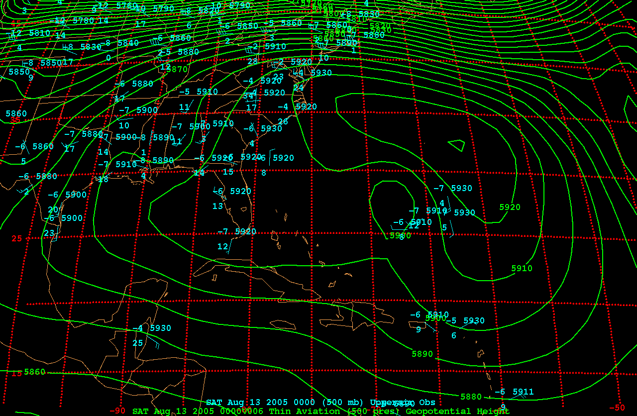
this was a 0Z garp image comparing the obs vs the 6 hour forecast of GFS. Seems like it still cannot get a ridge correct
0 likes   

shaggy
Category 2
Category 2
Posts: 655
Joined: Fri Jul 22, 2005 4:14 pm
Location: greenville, n.c.

#2 Postby shaggy » Fri Aug 12, 2005 7:37 pm

so if it under estimates the ridge should the gfdl and models that run off the GFS be wrong in such a sharp turn NE?
0 likes   

Derek Ortt

#3 Postby Derek Ortt » Fri Aug 12, 2005 7:38 pm

it does provide somewhat less confidence in a turn as early as they are indicating
0 likes   

Matt-hurricanewatcher

#4 Postby Matt-hurricanewatcher » Fri Aug 12, 2005 7:39 pm

Looks like if that ridge where not to weaken at all. This system would go north or north-northwest for another 3 or 4 degrees. Then turn west-northwest on the back side of it.
0 likes   

User avatar
Ivanhater
Storm2k Moderator
Storm2k Moderator
Posts: 11166
Age: 38
Joined: Fri Jul 01, 2005 8:25 am
Location: Pensacola

#5 Postby Ivanhater » Fri Aug 12, 2005 7:40 pm

derek take a look at this and please explain, you can see the due south sinking motion to the north of irene, making you think that she is under the ridge but you can also see the convection over the center move due north at the end.....i just dont understand

http://www.atmos.washington.edu/~ovens/ ... nhanced+12
0 likes   

User avatar
deltadog03
Professional-Met
Professional-Met
Posts: 3580
Joined: Tue Jul 05, 2005 6:16 pm
Location: Macon, GA

#6 Postby deltadog03 » Fri Aug 12, 2005 7:40 pm

thats actually a pretty strong ridge...590 line is well inland and not too mention the ridge to the north...hmmm thanks derek
0 likes   

Derek Ortt

#7 Postby Derek Ortt » Fri Aug 12, 2005 7:43 pm

dont go by the lines, those are GFS lines, which are too weak.

the convection is rotating around the center
0 likes   

User avatar
deltadog03
Professional-Met
Professional-Met
Posts: 3580
Joined: Tue Jul 05, 2005 6:16 pm
Location: Macon, GA

#8 Postby deltadog03 » Fri Aug 12, 2005 7:45 pm

ok, thanks...well, that looks fairly strong anyway, and if there underdone we have a problem
0 likes   

User avatar
Ivanhater
Storm2k Moderator
Storm2k Moderator
Posts: 11166
Age: 38
Joined: Fri Jul 01, 2005 8:25 am
Location: Pensacola

#9 Postby Ivanhater » Fri Aug 12, 2005 7:46 pm

Derek Ortt wrote:dont go by the lines, those are GFS lines, which are too weak.

the convection is rotating around the center


but did you see the due south sinking motion just to the north of irene, doesnt that mean the ridge is on top of it, or at least a pretty strong ridge or no? thanks
0 likes   

Derek Ortt

#10 Postby Derek Ortt » Fri Aug 12, 2005 7:52 pm

it means we do have a decent ridge north of irene... writing the new forecast now
0 likes   

User avatar
Ivanhater
Storm2k Moderator
Storm2k Moderator
Posts: 11166
Age: 38
Joined: Fri Jul 01, 2005 8:25 am
Location: Pensacola

#11 Postby Ivanhater » Fri Aug 12, 2005 7:54 pm

Derek Ortt wrote:it means we do have a decent ridge north of irene... writing the new forecast now


dang it , i thought i was seeing it right...thanks so much
0 likes   

mahicks
Category 1
Category 1
Posts: 329
Joined: Tue Jul 05, 2005 10:25 pm

#12 Postby mahicks » Fri Aug 12, 2005 7:56 pm

And this means>?????
0 likes   

User avatar
Nimbus
Category 5
Category 5
Posts: 5444
Joined: Mon Jul 19, 2004 10:54 am

#13 Postby Nimbus » Fri Aug 12, 2005 8:02 pm

The convection has been expanding quite rapidly.
I've been watching the area south of the Carolinas start to fill in.
That ULL pushing north into Mississippi is kind of pushing up the western side of the ridge.

Hope it migrates east toward the coast later in the forecast.
0 likes   

du1st

#14 Postby du1st » Fri Aug 12, 2005 8:06 pm

[quote="Nimbus"]The convection has been expanding quite rapidly.
I've been watching the area south of the Carolinas start to fill in.
That ULL pushing north into Mississippi is kind of pushing up the western side of the ridge.

What would that mean?
Last edited by du1st on Fri Aug 12, 2005 8:11 pm, edited 1 time in total.
0 likes   

shaggy
Category 2
Category 2
Posts: 655
Joined: Fri Jul 22, 2005 4:14 pm
Location: greenville, n.c.

#15 Postby shaggy » Fri Aug 12, 2005 8:08 pm

this is why my concern has been growing today since the ridge looked stronger and seemed to be sinking southward on WV imagery.Not sure what to think at the moment because NHC has been consistent in their forecast so no reason to doubt them just yet


also shouldn't the swift West to east zonal flow over the NE thats moving off the coast help to strengthen the ridge derek?
0 likes   

du1st

#16 Postby du1st » Fri Aug 12, 2005 8:10 pm

opps my bad sorry. :oops:
0 likes   

User avatar
storms in NC
S2K Supporter
S2K Supporter
Posts: 2338
Joined: Thu Jul 28, 2005 2:58 pm
Location: Wallace,NC 40 miles NE of Wilm
Contact:

#17 Postby storms in NC » Fri Aug 12, 2005 8:12 pm

DT's update is up
0 likes   

djtil
Category 2
Category 2
Posts: 699
Joined: Fri Jul 08, 2005 10:09 am

#18 Postby djtil » Fri Aug 12, 2005 8:13 pm

Last edited by djtil on Fri Aug 12, 2005 8:13 pm, edited 1 time in total.
0 likes   

User avatar
CronkPSU
S2K Supporter
S2K Supporter
Posts: 2021
Joined: Sun Aug 07, 2005 10:44 pm
Location: Avalon Park, FL

#19 Postby CronkPSU » Fri Aug 12, 2005 8:13 pm

storms in NC wrote:DT's update is up


link for us who are new? i have heard his name mentioned a lot lately as someone who is trusted
0 likes   

User avatar
storms in NC
S2K Supporter
S2K Supporter
Posts: 2338
Joined: Thu Jul 28, 2005 2:58 pm
Location: Wallace,NC 40 miles NE of Wilm
Contact:

#20 Postby storms in NC » Fri Aug 12, 2005 8:16 pm

0 likes   


Return to “Talkin' Tropics”

Who is online

Users browsing this forum: pepecool20 and 236 guests