Maine? MAINE?
I live in NJ right by NYC and its not even a threat to me, none of hte met's are mentioning it and those westerlies will probably sweep it right out to sea.
How is it a threat to MAINE?
Irene a New England storm?
Moderator: S2k Moderators
Forum rules

The posts in this forum are NOT official forecasts and should not be used as such. They are just the opinion of the poster and may or may not be backed by sound meteorological data. They are NOT endorsed by any professional institution or STORM2K. For official information, please refer to products from the National Hurricane Center and National Weather Service.
-
Trader Ron

- S2K Supporter

- Posts: 928
- Joined: Tue Jul 22, 2003 7:25 pm
- Location: Naples,Fl
- Contact:
Re: ...
WXFIEND wrote:Maine? MAINE?
I live in NJ right by NYC and its not even a threat to me, none of hte met's are mentioning it and those westerlies will probably sweep it right out to sea.
How is it a threat to MAINE?
I agree. When i lived on Long Island,the majority of the time, you could count on the Westerlies taking a storm North and East of the area.
We'll see...
0 likes

whats this all about the little turn to the northwest!! That makes me wonder 
http://hurricane.methaz.org/cgi-bin/map ... zoomsize=2
http://hurricane.methaz.org/cgi-bin/map ... zoomsize=2
0 likes
-
wxwatcher91

- Category 5

- Posts: 1606
- Joined: Wed Jul 06, 2005 2:43 pm
- Location: Keene, NH
- Contact:
just to remind everyone... Long Island, Nantucket, and southern Connecticut and Rhode Island are now in the the forecast cone.
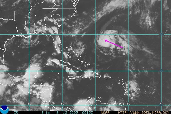
here is an image of the current surface data... I usually try to save a lot of the pics and make a loop of my... it is very useful...

also try out http://www.goes.noaa.gov/srcheast.html for an archive of sat images.
here is an image of the current surface data... I usually try to save a lot of the pics and make a loop of my... it is very useful...
also try out http://www.goes.noaa.gov/srcheast.html for an archive of sat images.
0 likes
-
JamesFromMaine2

- Category 4

- Posts: 989
- Joined: Tue Jul 19, 2005 1:38 am
- Location: Portland Maine USA
- Contact:
Re: ...
WXFIEND wrote:Maine? MAINE?
I live in NJ right by NYC and its not even a threat to me, none of hte met's are mentioning it and those westerlies will probably sweep it right out to sea.
How is it a threat to MAINE?
All I know is that the Meteorologests here in Maine said it was something we needed to keep an eye on cause we could be getting it!
0 likes
-
New Englander
- Tropical Depression

- Posts: 55
- Joined: Thu Aug 26, 2004 3:13 pm
- Location: Middleboro Massachusetts
This is from the NECN weather blog For the New England area.
Here Is the Link: http://weather.boston.com/blog/
As for Tropical Storm Irene, she's still a strong tropical storm as of this writing, but I expect she'll be classified as a hurricane by the end of Friday. While the trend in our guidance has been to "recurve" Irene out to sea farther away from the coastline than was depicted yesterday, I'm suspicious of this trend. Our Bermuda High will be pulsing late this weekend into early next week, and it's not natural to allow the storm to turn north, directly into an area of high pressure. At this stage of the game - which is still very early when dealing with tropical systems that can change over 5 hours, let alone 5 days - I still think a forecast of taking the storm just offshore of the Outer Banks of North Carolina Tuesday, and parallel to the shore up to at least Southern NJ Wednesday seems like the best track at this point. From there, it still seems too early to speculate, though clearly the farther south one is in New England, the more possible effects we could see. We've been watching this storm for a long time at NECN and we always give the latest information - as well as the National Hurricane Center forecast track and cone of probability - in our broadcasts. Feel free to check back this weekend, as I'll likely post a special update on Irene at some point over the weekend.
0 likes
-
wxwatcher91
- Category 5
- Posts: 1606
- Joined: Wed Jul 06, 2005 2:43 pm
- Location: Keene, NH
- Contact:
-
Tri-State_1925

- Category 1

- Posts: 341
- Joined: Fri Aug 13, 2004 11:16 am
- Location: Worcester Hills, MA
I haven't been following this storm much...last I heard it was heading out to sea a few days ago.
Over the last 10 years or so, storms threatening NE were blocked or pushed out to sea by fronts and whatnot. This thing will probably head out to sea too. Not hearing much buzz around these parts.
Over the last 10 years or so, storms threatening NE were blocked or pushed out to sea by fronts and whatnot. This thing will probably head out to sea too. Not hearing much buzz around these parts.
0 likes
Who is online
Users browsing this forum: Dean_175 and 82 guests