


EDIT: whoops, the image ended up kinda small
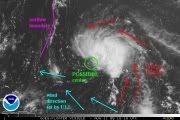
on the quikSCAT too... I see southerly wind flow, I see southeasterly wind flow, I see easterly wind flow; but where westerly and flow should be is light winds and in the general direction of east...
comments are not welcome: they are NEEDED!


