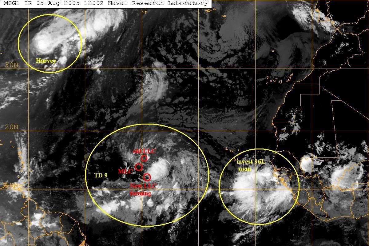
TD9 has split off with the LLC moving NW and the apparent MLC moving more toward the west. There is still a chance that we may have a new LLC form a little further south. However, at this time the chances are greater that this system is done.
Comments welcome
TD 9 Split
Moderator: S2k Moderators
Forum rules

The posts in this forum are NOT official forecasts and should not be used as such. They are just the opinion of the poster and may or may not be backed by sound meteorological data. They are NOT endorsed by any professional institution or STORM2K. For official information, please refer to products from the National Hurricane Center and National Weather Service.
-
ThunderMate
- Tropical Storm

- Posts: 215
- Joined: Mon Jul 11, 2005 10:18 am
- Location: Virginia Beach, Virginia
- Contact:
-
deltadog03

- Professional-Met

- Posts: 3580
- Joined: Tue Jul 05, 2005 6:16 pm
- Location: Macon, GA
-
skysummit

- S2K Supporter

- Posts: 5305
- Age: 50
- Joined: Tue Aug 31, 2004 11:09 pm
- Location: Ponchatoula, LA
- Contact:
Re: TD 9 Split
stormernie wrote:TD9 has split off with the LLC moving NW and the apparent MLC moving more toward the west. There is still a chance that we may have a new LLC form a little further south. However, at this time the chances are greater that this system is done.
Comments welcome
You are kidding with this comment right?
0 likes
-
WeatherEmperor
- S2K Supporter
- Posts: 4806
- Age: 41
- Joined: Thu Sep 04, 2003 2:54 pm
- Location: South Florida
-
deltadog03
- Professional-Met
- Posts: 3580
- Joined: Tue Jul 05, 2005 6:16 pm
- Location: Macon, GA
-
dixiebreeze

- S2K Supporter
- Posts: 5140
- Joined: Wed Sep 03, 2003 5:07 pm
- Location: crystal river, fla.
-
txwatcher91
- Category 5

- Posts: 1498
- Joined: Tue Aug 02, 2005 2:29 pm
-
WeatherEmperor
- S2K Supporter
- Posts: 4806
- Age: 41
- Joined: Thu Sep 04, 2003 2:54 pm
- Location: South Florida
-
Air Force Met
- Military Met

- Posts: 4372
- Age: 56
- Joined: Tue Jul 08, 2003 9:30 am
- Location: Roan Mountain, TN
Re: TD 9 Split
stormernie wrote:TD9 has split off with the LLC moving NW and the apparent MLC moving more toward the west. There is still a chance that we may have a new LLC form a little further south. However, at this time the chances are greater that this system is done.
Comments welcome
I don't think we'll see a new LLC...the existing one is fairly well established. VIS images show it does have a more northerly component than forecast.
0 likes
-
WeatherEmperor
- S2K Supporter
- Posts: 4806
- Age: 41
- Joined: Thu Sep 04, 2003 2:54 pm
- Location: South Florida
Re: TD 9 Split
Air Force Met wrote:stormernie wrote:TD9 has split off with the LLC moving NW and the apparent MLC moving more toward the west. There is still a chance that we may have a new LLC form a little further south. However, at this time the chances are greater that this system is done.
Comments welcome
I don't think we'll see a new LLC...the existing one is fairly well established. VIS images show it does have a more northerly component than forecast.
Do you think it will end up a fish?
<RICKY>
0 likes
-
Air Force Met
- Military Met
- Posts: 4372
- Age: 56
- Joined: Tue Jul 08, 2003 9:30 am
- Location: Roan Mountain, TN
ThunderMate wrote:TD9 will not go out to sea. It will continue WNW towards the US coastline.
Climo is against that scenario. The system is already past 16N. Looking back in time, only one storm in history has ever been in that location (within 120NM of it) and made landfall on the US coast....a storm in 1893.
So...unless it relocates well to the south...climo is very much against this system reaching the US. The models which were sending it back west and WNW did so when it was initialized as moving at 280 or so and a lot further south. As it stands now...it is already well north of the forecasts and moving to the right of them. So...the forecast tracks are already busted.
0 likes
-
cycloneye
- Admin

- Posts: 148852
- Age: 69
- Joined: Thu Oct 10, 2002 10:54 am
- Location: San Juan, Puerto Rico
As I said in another thread this is very close to being an open wave if it is one already.
0 likes
Visit the Caribbean-Central America Weather Thread where you can find at first post web cams,radars
and observations from Caribbean basin members Click Here
and observations from Caribbean basin members Click Here
-
wxwatcher91

- Category 5
- Posts: 1606
- Joined: Wed Jul 06, 2005 2:43 pm
- Location: Keene, NH
- Contact:
-
Air Force Met
- Military Met
- Posts: 4372
- Age: 56
- Joined: Tue Jul 08, 2003 9:30 am
- Location: Roan Mountain, TN
Re: TD 9 Split
WeatherEmperor wrote: Do you think it will end up a fish?
<RICKY>
Yes I do. Even if I had not looked at any models...I would call it a fish. Why? Climo. Storms that are that far east and already at 16N don't make it to the US....one in the last 150 years. It would take an extra-ordinary set of events to drive it back west.
Of course...given that it's naked now...it may not last long.
0 likes
-
jax
Re: TD 9 Split
Air Force Met wrote:WeatherEmperor wrote: Do you think it will end up a fish?
<RICKY>
Yes I do. Even if I had not looked at any models...I would call it a fish. Why? Climo. Storms that are that far east and already at 16N don't make it to the US....one in the last 150 years. It would take an extra-ordinary set of events to drive it back west.
Of course...given that it's naked now...it may not last long.
climo also says we won't have 3 named storms by this point in the
season... Climo isn't very reliable this year...
0 likes
-
Air Force Met
- Military Met
- Posts: 4372
- Age: 56
- Joined: Tue Jul 08, 2003 9:30 am
- Location: Roan Mountain, TN
wxwatcher91 wrote:can someone post a visual because I think mine is pretty off lol but here is what I see...
I don't think there is a new LLC forming on the south side. The vis loops show the old LLC is pretty established and tight. The only time new LLC's form is when there is a broad area of low pressure and then they usually form on the north side. TD 9 has a good circulation...but it is moving more northerly than forecast and into drier air and also cooler SST's. Gonna be difficult to get a good ball of convection back.
0 likes
-
vbhoutex

- Storm2k Executive
- Posts: 29141
- Age: 74
- Joined: Wed Oct 09, 2002 11:31 pm
- Location: Cypress, TX
- Contact:
Wxwatcher91 I only see one CC using the floater and it is the one you label old llcc. I see no indications of another one forming at this time at ML or LL.
AFM's post pretty much says it all right now. Obviously things could change, but I am not going to hold my breath. TD#9 is moving into somewhat hostile territory and doesn't look to me like it has its' wagons circled very tightly to defend itself.
AFM's post pretty much says it all right now. Obviously things could change, but I am not going to hold my breath. TD#9 is moving into somewhat hostile territory and doesn't look to me like it has its' wagons circled very tightly to defend itself.
0 likes
Who is online
Users browsing this forum: No registered users and 98 guests