extremely newbie forecasted path-UPDATED

This is the general tropical discussion area. Anyone can take their shot at predicting a storms path.

Moderator: S2k Moderators

Forum rules

The posts in this forum are NOT official forecasts and should not be used as such. They are just the opinion of the poster and may or may not be backed by sound meteorological data. They are NOT endorsed by any professional institution or STORM2K. For official information, please refer to products from the National Hurricane Center and National Weather Service.

Help Support Storm2K
Message
Author
jkt21787
Category 5
Category 5
Posts: 2061
Joined: Tue Aug 31, 2004 5:27 pm
Location: Memphis, TN

#21 Postby jkt21787 » Thu Aug 04, 2005 11:36 pm

floridahurricaneguy wrote:
Tampa Bay Hurricane wrote:flhurricaneguy, by that path we'd get the ne quadrant and some wild winds over the bay. Wait and see game- a strong high would mean a more southerly path.

Big circulation center, we'd likely feel some of the fiercest winds as the inner bands gather strength from the hot bay water.

This would be a BAD scenario... :eek:


I originally really did have it going farther south but that path i had looked to far south but I guess now to far north. Oh well it was my first try. I dont know if I want to post another one though after this.

Matt

I've been just joking with you. That is actually a very plausible path (as said before), if things work out right. I believe it could be an Andrew/Frances type path and that is very near where yours is. As for the others, I don't know what they meant.
0 likes   

User avatar
Tampa Bay Hurricane
Category 5
Category 5
Posts: 5598
Age: 37
Joined: Fri Jul 22, 2005 7:54 pm
Location: St. Petersburg, FL

#22 Postby Tampa Bay Hurricane » Thu Aug 04, 2005 11:37 pm

Yes I agree this is a possible scenario if no major factors weaken the Ridge once it builds in (as the ridge is forecasted to do so by Tampa NWS)

Which is why i will be tracking this very closely for the next 10 days at least
0 likes   

User avatar
fci
S2K Supporter
S2K Supporter
Posts: 3324
Joined: Tue Sep 14, 2004 10:29 am
Location: Lake Worth, FL

#23 Postby fci » Thu Aug 04, 2005 11:39 pm

floridahurricaneguy wrote:
Tampa Bay Hurricane wrote:flhurricaneguy, by that path we'd get the ne quadrant and some wild winds over the bay. Wait and see game- a strong high would mean a more southerly path.

Big circulation center, we'd likely feel some of the fiercest winds as the inner bands gather strength from the hot bay water.

This would be a BAD scenario... :eek:


I originally really did have it going farther south but that path i had looked to far south but I guess now to far north. Oh well it was my first try. I dont know if I want to post another one though after this.

Matt


Matt:
POST AGAIN!
It takes guts to put it out there and don't let the "experts" (all amateurs too, I might add); get you down.
If they are so smart, they can post their forecasts too.
0 likes   

floridahurricaneguy
Category 1
Category 1
Posts: 312
Joined: Tue Jul 19, 2005 10:37 pm
Location: Tampa,FL
Contact:

#24 Postby floridahurricaneguy » Thu Aug 04, 2005 11:39 pm

Maybe I overreacted to. Should not have gotten to serious. I guess I felt like everyone thought it was dumb making me feel dumb. lol

Here is a slightly revised one. (sorry that one was to big i just posted)
Image
0 likes   

jkt21787
Category 5
Category 5
Posts: 2061
Joined: Tue Aug 31, 2004 5:27 pm
Location: Memphis, TN

#25 Postby jkt21787 » Thu Aug 04, 2005 11:43 pm

Wow, thats big! Edit: Thats better :D

That's still good. Again I never thought your first one was bad or wishing, maybe Brent and Jacob did. Its so possible its scary since you just got there in Tampa!
0 likes   

Brent
S2K Supporter
S2K Supporter
Posts: 38266
Age: 37
Joined: Sun May 16, 2004 10:30 pm
Location: Tulsa Oklahoma
Contact:

#26 Postby Brent » Thu Aug 04, 2005 11:49 pm

Anything's possible... I just found it strange you'd bring it in just south of Tampa when it's not gonna happen for 10 days.

If your right, more power to you. It looked suspicious even if that wasn't your intention. :wink:
0 likes   
#neversummer

User avatar
Tampa Bay Hurricane
Category 5
Category 5
Posts: 5598
Age: 37
Joined: Fri Jul 22, 2005 7:54 pm
Location: St. Petersburg, FL

#27 Postby Tampa Bay Hurricane » Thu Aug 04, 2005 11:52 pm

flhurricaneguy great job on the maps! 8-)
Very good prediction also, because this could be a very possible scenario given the Ridge
0 likes   

floridahurricaneguy
Category 1
Category 1
Posts: 312
Joined: Tue Jul 19, 2005 10:37 pm
Location: Tampa,FL
Contact:

#28 Postby floridahurricaneguy » Thu Aug 04, 2005 11:55 pm

Tampa Bay Hurricane wrote:flhurricaneguy great job on the maps! 8-)
Very good prediction also, because this could be a very possible scenario given the Ridge


In all the truth I am predicting a east coast florida landfall. Really anywhere is possible. It might seem I was -removed- but I predicted south florida landfall and then travel NW or WNW across the state similar to Frances. I know it looked intentional but it wasnt. Its a very likely scenario but you who knows right now. I will as time goes on.

Matt
0 likes   

User avatar
wxmann_91
Category 5
Category 5
Posts: 8013
Age: 34
Joined: Fri Jul 15, 2005 2:49 pm
Location: Southern California
Contact:

#29 Postby wxmann_91 » Thu Aug 04, 2005 11:57 pm

Great job FLWxGuy! Great maps BTW! :D

Keep posting, who knows, it might come true. :eek:
0 likes   

User avatar
EDR1222
S2K Supporter
S2K Supporter
Posts: 1253
Joined: Mon Nov 10, 2003 12:58 pm
Location: Melbourne, FL

#30 Postby EDR1222 » Thu Aug 04, 2005 11:59 pm

The following post is NOT an official forecast and should not be used as such. It is just the opinion of the poster and may or may not be backed by sound meteorological data. It is NOT endorsed by any professional institution including storm2k.org For Official Information please refer to the NHC and NWS products.

First, still a big question whether it will develope at all.

If it does, one thing to watch for is if the system does make it close to the islands ( IMO it will not ) , is whether it passes through the Herbert Box . To me it looks like it is already taking a path to far to the north to do that. I know, I know, Andrew was the one storm of note that didn't pass through it and still hit Florida, but still something to watch.

I think if it does form and become a U.S. threat, it will be more toward the Carolinas or points northward IMHO.
0 likes   

User avatar
NCHurricane
Category 1
Category 1
Posts: 400
Age: 54
Joined: Sun Jul 24, 2005 2:50 pm
Location: Winterville, North Carolina, USA
Contact:

#31 Postby NCHurricane » Fri Aug 05, 2005 12:09 am

Thanks for the forecast flhurricaneguy. :D

Keep it up!
0 likes   

User avatar
jabber
Category 2
Category 2
Posts: 688
Joined: Mon Mar 24, 2003 5:36 pm
Location: Raleigh, NC (former Boynton Beach, Fl)

#32 Postby jabber » Fri Aug 05, 2005 6:43 am

Thats right over my house..... bad forcast :)
0 likes   

User avatar
wxwatcher91
Category 5
Category 5
Posts: 1606
Joined: Wed Jul 06, 2005 2:43 pm
Location: Keene, NH
Contact:

#33 Postby wxwatcher91 » Fri Aug 05, 2005 7:19 am

I'm not sure what to think at this point... I'm saying that the entire east coast should be watching it... there is even a chance that this could be a New England storm... (NOT a wishcast. if I said it IS going to be a NE storm THAT would be a wishcast :lol: )
0 likes   

User avatar
Thunder44
Category 5
Category 5
Posts: 5922
Age: 44
Joined: Mon Jun 09, 2003 7:53 pm
Location: New York City

#34 Postby Thunder44 » Fri Aug 05, 2005 7:30 am

floridahurricaneguy wrote:Maybe I overreacted to. Should not have gotten to serious. I guess I felt like everyone thought it was dumb making me feel dumb. lol

Here is a slightly revised one. (sorry that one was to big i just posted)
Image


Very nice for a newbie. :D But could you at least explain at least a little bit why do you it follow that path? Also when do you expect landfall in Florida? You don't have the times or dates on your forecast points on that map. :wink:
0 likes   

User avatar
KWT
Category 5
Category 5
Posts: 31416
Joined: Tue Aug 17, 2004 11:02 am
Location: UK!!!

#35 Postby KWT » Fri Aug 05, 2005 8:32 am

Well I might as well do one,used Google earth to get this,so here's the images,each little letter is 12hrs into the future,T stands for Tropical depression,S for tropical storm and H for hurricane:
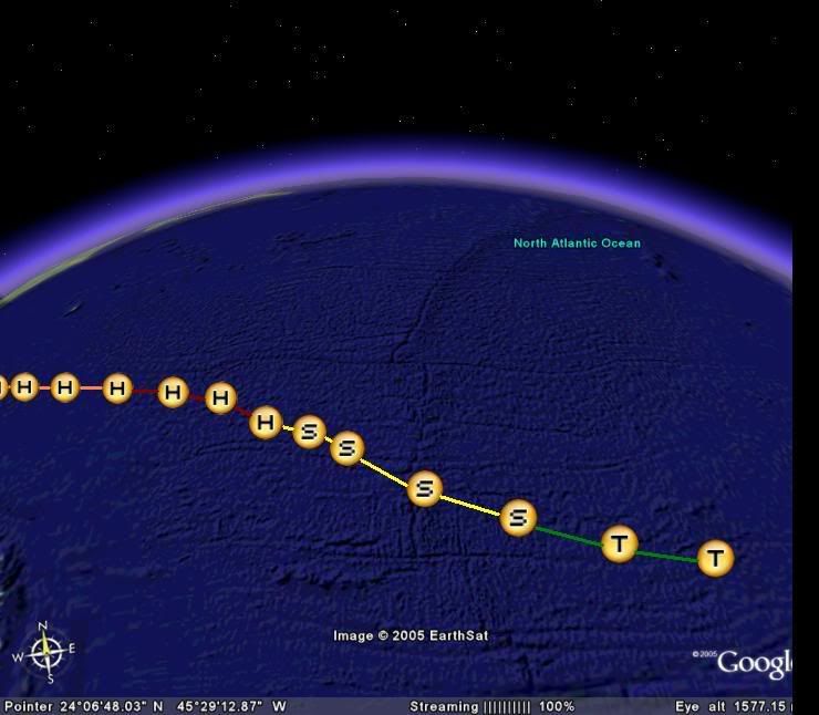
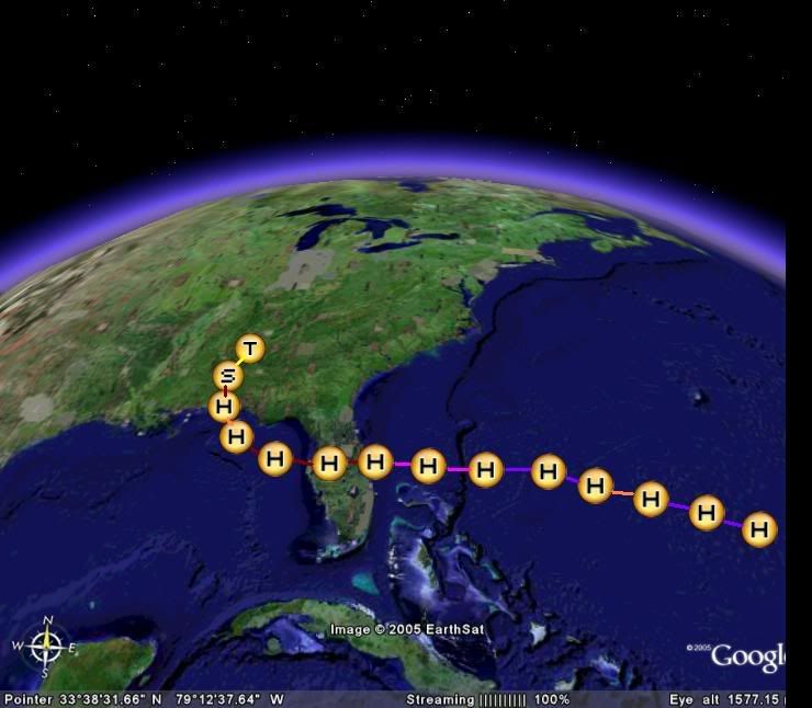
Image

Image

strength forecast:

12hrs:25kts
24hrs:35kts
36hrs:40kts
48hrs:50kts
60hrs:60kts
72hrs:65kts
84hrs:70kts
96hrs:75kts
108hrs:80kts
120hrs:90kts
132hrs:95kt
144hrs:100kts
156hrs:105kts
168hrs:100kts
180hrs:90kts(eyewall replacement)
192hrs:100kts
204hrs:110kts
216hrs:115kts
228hrs:120kts(starting eyewall replacement)
240hrs:80kts
252hrs:65kts
264hrs:75kts
276hrs:85kts
288hrs:65kts
300hrs:40kts
312hrs:25kts


Of course this is only my best guess and the later half will probably as badly forecast as GFS normal FI rubbish.I suppose the best way to describe this is abit like Frances last year.I suspect that the first 48hrs may be a bit optimistic and also it reaching category-2 in the GOM would largely depend on wether it comes out of Florida with a good structure or not.

As for the track,I belive that Harvey is now weakening quite quickly and if this continues to occur then the ridge may not be quite so badly affected by Harvey,which means that the storm may only take a WNW/NW track in the main before the ridge starts to build back somewhat sending it back on a W/WNW track,however although I veiw a Florida landfall as possible,certainly a east coast landfall is more then possible if it picks up more latitude then I expect and the ridge is indeed affected worse then I expected by Harvey.This is my ideas and as such this is required:


The following post is NOT an official forecast and should not be used as such. It is just the opinion of the poster and may or may not be backed by sound meteorological data. It is NOT endorsed by any professional institution including storm2k.org For Official Information please refer to the NHC and NWS products.
0 likes   

User avatar
bevgo
S2K Supporter
S2K Supporter
Posts: 634
Joined: Tue Jul 22, 2003 12:46 pm
Location: Ocean Springs, MS

LOL

#36 Postby bevgo » Fri Aug 05, 2005 9:27 am

Florida. Great forecast! Graphics were nice. It may or may not verify but hey--others on this board have been wrong too. Don't let a few comments bother you. Why should you care what the naysayers on the board say about you. Keep the graphics comming. I wish I had the knowledge and guts to attempt a forecast. Hang in there. There will always be some tacky comments. I have seen those type evey for the more experienced people on the board.

Come on guys. We are here to learn and have some fum. Let Florida have his fun and make his guesses with negative comments. If you disagree then educate all of as to why you disagree. PLEASE?????
0 likes   

floridahurricaneguy
Category 1
Category 1
Posts: 312
Joined: Tue Jul 19, 2005 10:37 pm
Location: Tampa,FL
Contact:

#37 Postby floridahurricaneguy » Fri Aug 05, 2005 11:37 am

Thunder44 wrote:
floridahurricaneguy wrote:Maybe I overreacted to. Should not have gotten to serious. I guess I felt like everyone thought it was dumb making me feel dumb. lol

Here is a slightly revised one. (sorry that one was to big i just posted)
Image


Very nice for a newbie. :D But could you at least explain at least a little bit why do you it follow that path? Also when do you expect landfall in Florida? You don't have the times or dates on your forecast points on that map. :wink:


The reason is totally I dont know. I dont have a real time frame at all. I expected it to I guess continue in WNW or W motion and make landfall along floridas coast. No real scientific reason now. As I get better I will start adding time frames and stuff. Now I just wanted to get a basic path done.

Matt
0 likes   

WeatherEmperor
S2K Supporter
S2K Supporter
Posts: 4806
Age: 41
Joined: Thu Sep 04, 2003 2:54 pm
Location: South Florida

#38 Postby WeatherEmperor » Fri Aug 05, 2005 11:41 am

Nice graphics. Not nice path.

<RICKY>
0 likes   

User avatar
Petmom
Tropical Storm
Tropical Storm
Posts: 148
Joined: Sat Jul 23, 2005 10:04 am
Location: Tampa, Florida
Contact:

#39 Postby Petmom » Fri Aug 05, 2005 1:44 pm

floridahurricaneguy wrote:Red is hurricane and yellow is TS and green, well i am sure you can guess.

I expected tropical storm within 48 hours and hurricane within 72 and possible landfall in FL as 2/3. But beyond that I dont really know.

Matt


Going in our direction. Well, I admire you for trying. LOL I don't even dare to try. Perhaps I wll someday.

:D
0 likes   

floridahurricaneguy
Category 1
Category 1
Posts: 312
Joined: Tue Jul 19, 2005 10:37 pm
Location: Tampa,FL
Contact:

#40 Postby floridahurricaneguy » Fri Aug 05, 2005 1:55 pm

I am currently not going along with my current path. In my opinion I am not expecting it to survive. Updated Path shortly.

Matt
0 likes   


Return to “Talkin' Tropics”

Who is online

Users browsing this forum: Team Ghost and 111 guests