Official 93L Invest thread=93L is not anymore at NRL
Moderator: S2k Moderators
Forum rules

The posts in this forum are NOT official forecasts and should not be used as such. They are just the opinion of the poster and may or may not be backed by sound meteorological data. They are NOT endorsed by any professional institution or STORM2K. For official information, please refer to products from the National Hurricane Center and National Weather Service.

-
Astro_man92

- Category 5

- Posts: 1493
- Joined: Sun Jul 17, 2005 1:26 am
- Contact:
does it look as healthy as emily did at this time in it's development????Swimdude wrote:93L is having all the problems and characteristics as Emily. Shear to begin with. A path towards the Yucatan. Moving West at 20 mph. [That's definately familiar!] This deja vu is killing me.
Still I don't think we have another Emily on our hands at least this soon after it happened
0 likes
-
gkrangers
No, Emily was already a TS. ALTHOUGH, some also wanted to call Emily an open wave at this point, too.Astro_man92 wrote:does it look as healthy as emily did at this time in it's development????Swimdude wrote:93L is having all the problems and characteristics as Emily. Shear to begin with. A path towards the Yucatan. Moving West at 20 mph. [That's definately familiar!] This deja vu is killing me.
Still I don't think we have another Emily on our hands at least this soon after it happened
0 likes
-
Astro_man92
- Category 5
- Posts: 1493
- Joined: Sun Jul 17, 2005 1:26 am
- Contact:
gkrangers wrote:No, Emily was already a TS. ALTHOUGH, some also wanted to call Emily an open wave at this point, too.Astro_man92 wrote:does it look as healthy as emily did at this time in it's development????Swimdude wrote:93L is having all the problems and characteristics as Emily. Shear to begin with. A path towards the Yucatan. Moving West at 20 mph. [That's definately familiar!] This deja vu is killing me.
Still I don't think we have another Emily on our hands at least this soon after it happened
ya emily didn't develope an Eye untill she was a cat 3 right??
0 likes

-
Brent
- S2K Supporter

- Posts: 38673
- Age: 37
- Joined: Sun May 16, 2004 10:30 pm
- Location: Tulsa Oklahoma
- Contact:
Astro_man92 wrote:gkrangers wrote:No, Emily was already a TS. ALTHOUGH, some also wanted to call Emily an open wave at this point, too.Astro_man92 wrote:does it look as healthy as emily did at this time in it's development????Swimdude wrote:93L is having all the problems and characteristics as Emily. Shear to begin with. A path towards the Yucatan. Moving West at 20 mph. [That's definately familiar!] This deja vu is killing me.
Still I don't think we have another Emily on our hands at least this soon after it happened
ya emily didn't develope an Eye untill she was a cat 3 right??
Emily was strange... waited forever for it to become a hurricane, then after the Hurricane Warnings are dropped, it finally becomes a hurricane.
0 likes
#neversummer
-
dixiebreeze

- S2K Supporter
- Posts: 5140
- Joined: Wed Sep 03, 2003 5:07 pm
- Location: crystal river, fla.
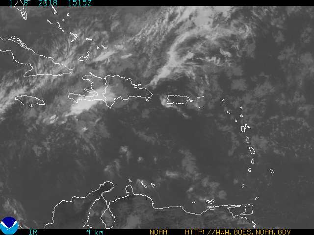
93L seems to be taking shape and showing some outflow pattern:
http://www.ssd.noaa.gov/PS/TROP/DATA/RT/WATL/IR4/20.jpg
http://www.ssd.noaa.gov/PS/TROP/DATA/RT/WATL/IR4/20.jpg
0 likes
-
Astro_man92
- Category 5
- Posts: 1493
- Joined: Sun Jul 17, 2005 1:26 am
- Contact:
Brent wrote:I think Recon will probably find a TD tomorrow... assuming it doesn't fall apart overnight.
I hope it won't I'm getting sick of this lull it is like. "Now you invests if you get to develope a LLC i'm going to whip you and you wil then disipate" shouts the lull while the invest cower in fear. then 92L says " hmmm that lull dosn't scare me i'll develope a LLC if it she likes it or not" so 92L trys to develoe a LLC but the lull catches him and he starts to disipate but trys to come back to health. 93L see's 92L disipating and says " 92L was right that lull is mean i'll try and get an LLC" and now the rest of the story is still forseen lol
what do you think pretty funny huh lol
0 likes
-
wx247

- S2K Supporter
- Posts: 14279
- Age: 42
- Joined: Wed Feb 05, 2003 10:35 pm
- Location: Monett, Missouri
- Contact:
Looks pretty good. I am not sure that there is a TD here yet, but wouldn't be surprised if this doesn't continue to organize overnight. Can't wait to see what recon finds as it is so very important.
0 likes
Personal Forecast Disclaimer:
The posts in this forum are NOT official forecast and should not be used as such. They are just the opinion of the poster and may or may not be backed by sound meteorological data. They are NOT endorsed by any professional institution or storm2k.org. For official information, please refer to the NHC and NWS products.
The posts in this forum are NOT official forecast and should not be used as such. They are just the opinion of the poster and may or may not be backed by sound meteorological data. They are NOT endorsed by any professional institution or storm2k.org. For official information, please refer to the NHC and NWS products.
-
gkrangers

-
cycloneye
- Admin

- Posts: 148855
- Age: 69
- Joined: Thu Oct 10, 2002 10:54 am
- Location: San Juan, Puerto Rico
TROPICAL WAVE ALONG 55W SOUTH OF 18N MOVING WEST 20 KT WITH A
1012 MB LOW NEAR 11N/12N. CONVECTION ASSOCIATED WITH THIS WAVE
IS QUITE ACTIVE...WITH SCATTERED MODERATE/ISOLATED STRONG
CONVECTION EXTENDING FROM 10N-17N ALONG AND W OF THE WAVE AXIS
TO 58W. SURFACE OBSERVATIONS SHOW THAT THE WAVE IS AT THE
LEADING EDGE OF A WIND/AFRICAN DUST SURGE...WITH WINDS OF 20-25
KT BEHIND THE WAVE. WHILE LITTLE IN THE WAY OF ORGANIZATION IS
CURRENTLY NOTED...CONDITIONS MAY BECOME SOMEWHAT MORE FAVORABLE
FOR DEVELOPMENT DURING THE NEXT 24-36 HOURS AS THE WAVE MOVES
AROUND THE SW PERIPHERY OF THE MID/UPPER LEVEL HIGH OVER THE
CENTRAL ATLC. ON ITS CURRENT MOTION...SHOWERS AND TSTMS WILL
BEGIN TO AFFECT THE WINDWARD ISLANDS LATE TONIGHT OR EARLY SUN
WITH GUSTY WINDS AND LOCALLY HEAVY RAINS.
The above is the discussion at 8:05 PM from TPC.
0 likes
Visit the Caribbean-Central America Weather Thread where you can find at first post web cams,radars
and observations from Caribbean basin members Click Here
and observations from Caribbean basin members Click Here
-
DoctorHurricane2003
-
deltadog03

- Professional-Met

- Posts: 3580
- Joined: Tue Jul 05, 2005 6:16 pm
- Location: Macon, GA
-
cycloneye
- Admin
- Posts: 148855
- Age: 69
- Joined: Thu Oct 10, 2002 10:54 am
- Location: San Juan, Puerto Rico
TROPICAL WEATHER OUTLOOK
NWS TPC/NATIONAL HURRICANE CENTER MIAMI FL
1030 PM EDT SAT JUL 30 2005
FOR THE NORTH ATLANTIC...CARIBBEAN SEA AND THE GULF OF MEXICO...
ANOTHER TROPICAL WAVE...LOCATED ABOUT 200 MILES EAST OF THE CENTRAL
AND SOUTHERN LESSER ANTILLES...IS MOVING WESTWARD AT 20 MPH. THIS
SYSTEM HAS CHANGED LITTLE...AND UPPER-LEVEL WINDS ARE ONLY
MARGINALLY FAVORABLE FOR SOME SLOW DEVELOPMENT TO OCCUR. HOWEVER
...AN AIR FORCE RESERVE UNIT RECONNAISSANCE AIRCRAFT IS SCHEDULED
TO INVESTIGATE THIS SYSTEM SUNDAY AFTERNOON...IF NECESSARY.
ELSEWHERE...TROPICAL STORM FORMATION IS NOT EXPECTED THROUGH MONDAY.
FORECASTER STEWART
I knew I was seeing it less organized.
0 likes
Visit the Caribbean-Central America Weather Thread where you can find at first post web cams,radars
and observations from Caribbean basin members Click Here
and observations from Caribbean basin members Click Here
Who is online
Users browsing this forum: No registered users and 46 guests