

The following post is NOT an official forecast and should not be used as such. It is just the opinion of the poster and may or may not be backed by sound meteorological data. It is NOT endorsed by any professional institution including storm2k.org For Official Information please refer to the NHC and NWS products.
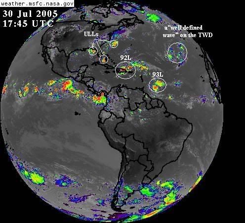
Western Atlantic Tropical Summary WATS UP on July 30, 2005
<img src="http://www.diamondheadweather.com/wats20050730.jpg">
Los Tres Upper Level Lows continue to be the dominant feature north of
20 degrees in the western Atlantic.
ULL-1 looks weaker this morning, and I do not expect tropical
development from this area.
ULL-2 - is still quite strong and should be called the mauler of
Invest 92L, as it has sheared invest 92 pretty badly.
ULL-3 is very strong, and is contributing to the demise of invest 92L as well.
Note the green line - that's the dominant flow created be ULL-2 and
ULL-3 - the winds aloft are flowing along the green line and stripping
invest 92L on down.
Invest 92L, near Puerto Rico, looks even worse today, and development
in not expected in the next 48 hours, and likely not at all.
Invest 93L is looking much better this morning as it approaches the lesser
Antilles. This system warrants watching for the next few days as it
prepares to enter the Caribbean Sea. 92L did leave moisture behind,
making conditions in the eastern Caribbean sea more favorable.
Comments welcomed!
David
WATS UP - July 30, 2005
Moderator: S2k Moderators
Forum rules

The posts in this forum are NOT official forecasts and should not be used as such. They are just the opinion of the poster and may or may not be backed by sound meteorological data. They are NOT endorsed by any professional institution or STORM2K. For official information, please refer to products from the National Hurricane Center and National Weather Service.
WATS UP - July 30, 2005
0 likes
-
x-y-no

- Category 5

- Posts: 8359
- Age: 65
- Joined: Wed Aug 11, 2004 12:14 pm
- Location: Fort Lauderdale, FL
Yeah ... ULL #2 sure is tearing the heck out of 92L. And since it's not in any hurry to get out of the way, I think this spells the end for that system.
Interesting to see 93L starting to resurrect. No hint of any spin there, but it's a nice chunk of energy which could conceivably develop in the next couple of days. Or else it could just keep trucking on into the EPAC, I suppose.
Interesting to see 93L starting to resurrect. No hint of any spin there, but it's a nice chunk of energy which could conceivably develop in the next couple of days. Or else it could just keep trucking on into the EPAC, I suppose.
0 likes


-
deltadog03

- Professional-Met

- Posts: 3580
- Joined: Tue Jul 05, 2005 6:16 pm
- Location: Macon, GA
great maps...thanks....but wait a sec here guys. I think 92L split. I think the LLC will end up being S of DR...and if it continues to move WNW or W or whatever. I still give it a shot.. Thunderstorms are blowing up and clustering with a hint of LL spin. interesting to note that the Euro did have a "split" look to the wave in the future. I believe that this could be something to watch..any opinions??
0 likes
-
Hurricaneman

- Category 5
- Posts: 7404
- Age: 45
- Joined: Tue Aug 31, 2004 3:24 pm
- Location: central florida
-
Astro_man92

- Category 5
- Posts: 1493
- Joined: Sun Jul 17, 2005 1:26 am
- Contact:
-
Astro_man92
- Category 5
- Posts: 1493
- Joined: Sun Jul 17, 2005 1:26 am
- Contact:
-
wxwatcher91

- Category 5
- Posts: 1606
- Joined: Wed Jul 06, 2005 2:43 pm
- Location: Keene, NH
- Contact:
wow the 2pm TWD-
Atlantic Tropical Weather Discussion
--------------------------------------------------------------------------------
000
AXNT20 KNHC 301807
TWDAT
TROPICAL WEATHER DISCUSSION
NWS TPC/NATIONAL HURRICANE CENTER MIAMI FL
205 PM EDT SAT JUL 30 2005
TROPICAL WEATHER DISCUSSION FOR NORTH AMERICA...CENTRAL
AMERICA...GULF OF MEXICO...CARIBBEAN SEA...NORTHEASTERN
SECTIONS OF SOUTH AMERICA...AND ATLANTIC OCEAN TO THE
AFRICAN COAST FROM THE EQUATOR TO 32N. THE FOLLOWING
INFORMATION IS BASED ON SATELLITE IMAGERY...WEATHER
OBSERVATIONS...RADAR...AND METEOROLOGICAL ANALYSIS.
BASED ON 1200 UTC SURFACE ANALYSIS AND
SATELLITE IMAGERY THROUGH 1730 UTC.
...TROPICAL WAVES...
TROPICAL WAVE ALONG 40W SOUTH OF 18N MOVING WEST 15-20 KT. THE
WAVE IS DEFINED QUITE WELL ON SATELLITE IMAGERY BY A NORTHWARD
BULGE IN THE LOW AND MID LEVEL CLOUDS. SCATTERED MODERATE
CONVECTION IS IN A NARROW BAND FROM 12.5N-13.5N WEST OF THE WAVE
AXIS TO ABOUT 45W. CONVECTION REMAINS DISORGANIZED AS WAVE IS
EMBEDDED IN MID/UPPER LEVEL DRY AIR AND SUBSIDENCE ON THE EAST
SIDE OF A MID/UPPER LEVEL HIGH NEAR 16N52W.
TROPICAL WAVE ALONG 52W/53W SOUTH OF 18N MOVING WEST 20 KT.
CONVECTION ASSOCIATED WITH THIS WAVE IS QUITE ACTIVE...WITH
HIGH RESOLUTION VISIBLE SATELLITE IMAGERY INDICATES A WEAK LOW
LEVEL CIRCULATION NEAR 11N52W. SCATTERED MODERATE/ISOLATED
STRONG CONVECTION EXTENDS FROM 10N-14N ALONG AND W OF THE WAVE
AXIS TO 57W. SURFACE OBSERVATIONS SHOW THAT THE WAVE IS AT THE
LEADING EDGE OF A WIND SURGE...WITH WINDS OF 20-25 KT BEHIND THE
WAVE AND 10-15 KT WINDS AHEAD OF THE WAVE NEAR AND OVER THE
LESSER ANTILLES. HOWEVER...LITTLE IN THE WAY OF ORGANIZATION IS
NOTED. CONDITIONS MAY BECOME SOMEWHAT FAVORABLE FOR DEVELOPMENT
DURING THE NEXT 24 HOURS AS THE WAVE MOVES AROUND THE SOUTHERN
PERIPHERY OF THE MID/UPPER LEVEL HIGH NEAR 16N52W. ON ITS
CURRENT MOTION...SHOWERS AND TSTMS WILL BEGIN TO AFFECT THE
WINDWARD ISLANDS LATE TONIGHT OR EARLY SUN WITH GUSTY WINDS AND
LOCALLY HEAVY RAINS.
A WELL-DEFINED TROPICAL WAVE EXTENDS FROM THE ATLANTIC NEAR
22N67W SOUTH ACROSS THE EASTERN DOMINICAN REPUBLIC TO 8N70W
MOVING WEST 15-20 KT. SATELLITE IMAGERY...SURFACE OBSERVATIONS...
AND QUIKSCAT DATA SHOW THE POSITION OF THE WAVE QUITE WELL.
SCATTERED STRONG CONVECTION 120-150 W OF THE WAVE AND S OF
HISPANIOLA HAS DISSIPATED IN THE LAST FEW HOURS...WITH SIMILAR
CONVECTION DEVELOPING OVER THE DOMINICAN REPUBLIC DUE IN PART TO
DIURNAL HEATING. SATELLITE RAINFALL ESTIMATES INDICATE AMOUNTS
OF 4 INCHES ARE POSSIBLE OVER THIS AREA. LARGE AREA OF SCATTERED
MODERATE CONVECTION EXTENDS E FROM THE WAVE OVER ATLANTIC FROM N
COAST OF PUERTO RICO TO 22N AS FAR E AS 59W. WAVE IS UNDERNEATH
AN AREA OF S-SW UPPER LEVEL WINDS WHICH IS PRODUCING A
MARGINALLY UNFAVORABLE ENVIRONMENT FOR DEVELOPMENT. HEAVY RAINS
WILL CONTINUE TO SPREAD WEST ACROSS HISPANIOLA DURING THE NEXT
24 HOURS.
TROPICAL WAVE PREVIOUSLY INLAND OVER THE ISTHMUS OF TEHUANTEPEC
IS NOW MAINLY OVER THE PACIFIC WATERS SOUTH OF THE GULF OF
TEHUANTEPEC.
THREE "well defined waves" lol
0 likes


Who is online
Users browsing this forum: cycloneye, hurricanes1234, KirbyDude25, pepecool20, Ulf and 38 guests