Is Emily an open and shut case?

This is the general tropical discussion area. Anyone can take their shot at predicting a storms path.

Moderator: S2k Moderators

Forum rules

The posts in this forum are NOT official forecasts and should not be used as such. They are just the opinion of the poster and may or may not be backed by sound meteorological data. They are NOT endorsed by any professional institution or STORM2K. For official information, please refer to products from the National Hurricane Center and National Weather Service.

Help Support Storm2K
Message
Author
User avatar
alicia-w
S2K Supporter
S2K Supporter
Posts: 6400
Joined: Tue Aug 12, 2003 2:55 pm
Location: Tijeras, NM

#21 Postby alicia-w » Thu Jul 14, 2005 3:05 pm

djtil wrote:im pretty sure we were just discussing tracking...everyone knows timing intensity minima/maxima is impossible at this time.


the actual landfall for Dennis was not the same as it was forecasted at 4 days out. on wednesday the 6th, they were saying Louisiana.
0 likes   

User avatar
canegrl04
Category 5
Category 5
Posts: 2486
Joined: Thu Aug 26, 2004 5:37 pm
Location: Texas

#22 Postby canegrl04 » Thu Jul 14, 2005 3:06 pm

I remember with Dennis,all the models seemed to point from LA to Florida pan. It wasn't untill about 72 hours before landfall that they were all fixed on MS-Fl pan as the strike point.I would wait a few more days before I started talking strike point as definite
0 likes   

User avatar
southerngale
Retired Staff
Retired Staff
Posts: 27418
Joined: Thu Oct 10, 2002 1:27 am
Location: Southeast Texas (Beaumont area)

#23 Postby southerngale » Thu Jul 14, 2005 3:12 pm

Cindy was expected to hit Texas 2 days before it hit southeast Louisiana so although the NHC does an exceptional job with forecast tracks, it's not always written in stone.

With that said, I can only assume Emily will hit Mexico as that's how it looks now.
Last edited by southerngale on Thu Jul 14, 2005 3:16 pm, edited 1 time in total.
0 likes   

clfenwi
Category 5
Category 5
Posts: 3331
Joined: Thu Jun 09, 2005 12:54 pm

#24 Postby clfenwi » Thu Jul 14, 2005 3:14 pm

alicia-w wrote:
djtil wrote:im pretty sure we were just discussing tracking...everyone knows timing intensity minima/maxima is impossible at this time.


the actual landfall for Dennis was not the same as it was forecasted at 4 days out. on wednesday the 6th, they were saying Louisiana.


NHC forecast was not Louisana. Looking at this: http://www.nhc.noaa.gov/archive/2005/DE ... hics.shtml (and flipping on the five day forecast graphics),, they never went west of Mobile.

As contemporaneous discussions indicate, their forecast was centered on the model consenus... while there were a couple of models suggesting Louisana, the overall consensus was E AL/W FL.
0 likes   

User avatar
hicksta
Category 5
Category 5
Posts: 1108
Age: 35
Joined: Thu Jul 14, 2005 12:16 am
Location: Kemah Texas/ Baton Rogue LA

#25 Postby hicksta » Thu Jul 14, 2005 3:16 pm

southerngale wrote:Cindy was expected to hit Texas 2 days before it hit southeast Lousisiana so although the NHC does an exceptional job with forecast tracks, it's not always written in stone.

With that said, I can only assume Emily will hit Mexico as that's how it looks now.


you cant say that.. so much can change so quickly. anything can happen
0 likes   

User avatar
southerngale
Retired Staff
Retired Staff
Posts: 27418
Joined: Thu Oct 10, 2002 1:27 am
Location: Southeast Texas (Beaumont area)

#26 Postby southerngale » Thu Jul 14, 2005 3:17 pm

hicksta wrote:
southerngale wrote:Cindy was expected to hit Texas 2 days before it hit southeast Lousisiana so although the NHC does an exceptional job with forecast tracks, it's not always written in stone.

With that said, I can only assume Emily will hit Mexico as that's how it looks now.


you cant say that.. so much can change so quickly. anything can happen


I can't say what? :?:
0 likes   

clfenwi
Category 5
Category 5
Posts: 3331
Joined: Thu Jun 09, 2005 12:54 pm

#27 Postby clfenwi » Thu Jul 14, 2005 3:19 pm

alicia-w wrote:
djtil wrote:dennis was pretty open and shut from about 3-4 days in....and even from 5-6 days it only shifted about 200 miles east.

it looks to me that in this case its pretty open and shut considering there is basically 1 dominant steering feature firmly anchored in the GOM.....the only question is how far south.


I have to disagree. Until almost an hour or so out, we were being told it was a cat 3 or 4 storm and then something just happened!!!!

no such thing as open and shut.


Read the Saffir-Simpson definition of cat three:

http://www.nhc.noaa.gov/aboutsshs.shtml

Then go here:

http://photos.pensacolanewsjournal.com/

and scroll down and click on the galleries of Navarre and Navarre Beach.

They got hit by a category three storm...
0 likes   

Rainband

#28 Postby Rainband » Thu Jul 14, 2005 3:20 pm

hicksta wrote:
southerngale wrote:Cindy was expected to hit Texas 2 days before it hit southeast Lousisiana so although the NHC does an exceptional job with forecast tracks, it's not always written in stone.

With that said, I can only assume Emily will hit Mexico as that's how it looks now.


you cant say that.. so much can change so quickly. anything can happen
There is nothing evident to change the current thinking. The Models look at the present conditions and the future conditions. They are usually very good. Anything is always possible. But probable is the key here :wink:
Last edited by Rainband on Thu Jul 14, 2005 3:21 pm, edited 1 time in total.
0 likes   

User avatar
hicksta
Category 5
Category 5
Posts: 1108
Age: 35
Joined: Thu Jul 14, 2005 12:16 am
Location: Kemah Texas/ Baton Rogue LA

#29 Postby hicksta » Thu Jul 14, 2005 3:20 pm

how can you assume it will hit mexico... although the models point that way. didnt the models point it at cuba a day ago?? it will change.
0 likes   

Rainband

#30 Postby Rainband » Thu Jul 14, 2005 3:22 pm

hicksta wrote:how can you assume it will hit mexico... although the models point that way. didnt the models point it at cuba a day ago?? it will change.
they shifted south and as the ridge strengthens and build west they will most likely shift south again. BTW welcome to S2K where are you from??
0 likes   

User avatar
alicia-w
S2K Supporter
S2K Supporter
Posts: 6400
Joined: Tue Aug 12, 2003 2:55 pm
Location: Tijeras, NM

#31 Postby alicia-w » Thu Jul 14, 2005 3:22 pm

clfenwi wrote:
alicia-w wrote:
djtil wrote:dennis was pretty open and shut from about 3-4 days in....and even from 5-6 days it only shifted about 200 miles east.

it looks to me that in this case its pretty open and shut considering there is basically 1 dominant steering feature firmly anchored in the GOM.....the only question is how far south.


I have to disagree. Until almost an hour or so out, we were being told it was a cat 3 or 4 storm and then something just happened!!!!

no such thing as open and shut.


Read the Saffir-Simpson definition of cat three:

http://www.nhc.noaa.gov/aboutsshs.shtml

Then go here:

http://photos.pensacolanewsjournal.com/

and scroll down and click on the galleries of Navarre and Navarre Beach.

They got hit by a category three storm...


I live just 20 minutes from there. WELL aware of the damage. But I thought we were talking storm track.....

up until noon friday we were being told (here at the AFB) to expect winds of 140mph with FWB being a direct hit. It didnt happen. I'm not complaining, but I'm just trying to emphasize the point that this isnt an exact science and that it is NEVER open and shut.
Last edited by alicia-w on Thu Jul 14, 2005 3:26 pm, edited 1 time in total.
0 likes   

N2Storms
Category 1
Category 1
Posts: 324
Joined: Thu Sep 04, 2003 1:37 pm
Location: Panama City, Florida

#32 Postby N2Storms » Thu Jul 14, 2005 3:23 pm

Dennis did not behave exactly according to plan when he crossed over Cuba and Emily is going to be over land even longer. I'm sure all of you experienced Cane watchers have seen some strange things occur once they interact with land. Given that plus we are still talking almost a week before it could impact the U.S. I would not set any predictions in concrete. Who knows what changes in the synoptic pattern may occur between now and then. Something from the EPAC could influence her, a vigorous system coming down from the Rockies could influence her. Too many variables to factor in right now. I stated yesterday and I still maintain today, anyone living on the Texas coastline should watch very, very closely.
0 likes   

User avatar
southerngale
Retired Staff
Retired Staff
Posts: 27418
Joined: Thu Oct 10, 2002 1:27 am
Location: Southeast Texas (Beaumont area)

#33 Postby southerngale » Thu Jul 14, 2005 3:24 pm

hicksta wrote:how can you assume it will hit mexico... although the models point that way. didnt the models point it at cuba a day ago?? it will change.


Did you read my entire post? I gave an example of how the forecast track is sometimes wrong, then just said that I assume it's going where they say until I hear otherwise or see a reason for it to change. :)
0 likes   

User avatar
hicksta
Category 5
Category 5
Posts: 1108
Age: 35
Joined: Thu Jul 14, 2005 12:16 am
Location: Kemah Texas/ Baton Rogue LA

#34 Postby hicksta » Thu Jul 14, 2005 3:25 pm

ooo alright <3
0 likes   

clfenwi
Category 5
Category 5
Posts: 3331
Joined: Thu Jun 09, 2005 12:54 pm

#35 Postby clfenwi » Thu Jul 14, 2005 3:33 pm

hicksta wrote:how can you assume it will hit mexico... although the models point that way. didnt the models point it at cuba a day ago?? it will change.


The global forecast models that have had the best handle on Emily's future movement so far have kept Emily off of Cuba (and into the Yucatan) since Monday night/Tuesday morning.

The models that you are referring to are the limited area models. They have been highly sensitive to changes in Emily's course (or lack thereof). Their insistence on prematurely turning to Emily to the west-northwest / northwest have hurt their accuracy...
0 likes   

User avatar
stormie_skies
Category 5
Category 5
Posts: 3318
Joined: Tue Aug 12, 2003 9:25 pm
Location: League City, TX

#36 Postby stormie_skies » Thu Jul 14, 2005 3:47 pm

This seems like such an incredibly silly argument....especially to be having in multiple threads... :roll:

This system is at LEAST 4-5 days away from landfall...how anyone thinks they can say with absolute certainty that the track of the storm will not change one bit in five days is completely beyond me....

Right now, the models and the NHC think Mexico is the most likely place for Em's final landfall. I think EVERYONE agrees on that. That said, we ALL should remember that neither we nor the NHC have been endowed with supernatural powers, and that THINGS CHANGE.

I'll bet many of the same people who are completely convinced of a second Mexican landfall are also the people who were saying New Orleans and the TX/LA border should look out 5 days.....heck, even 4 days....before Dennis made landfall. Those posts were made with the same amount of certainty and within the same time frame....but models aren't perfect, and neither are we. Lets all just remember that, and let our posts reflect it.

[/soapbox]

:lol:
0 likes   

rockyman
Category 5
Category 5
Posts: 1967
Joined: Thu Jun 26, 2003 12:24 pm
Location: Dauphin Island, AL

#37 Postby rockyman » Thu Jul 14, 2005 3:55 pm

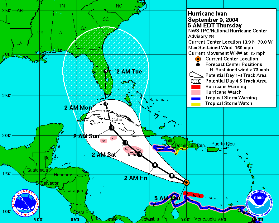
Five day forecast for Ivan:

Image
0 likes   

User avatar
hicksta
Category 5
Category 5
Posts: 1108
Age: 35
Joined: Thu Jul 14, 2005 12:16 am
Location: Kemah Texas/ Baton Rogue LA

#38 Postby hicksta » Thu Jul 14, 2005 3:56 pm

great point. on ivan
0 likes   

Rainband

#39 Postby Rainband » Thu Jul 14, 2005 3:58 pm

Way different setup with Ivan :wink:
0 likes   

User avatar
jasons2k
Storm2k Executive
Storm2k Executive
Posts: 8250
Age: 52
Joined: Wed Jul 06, 2005 12:32 pm
Location: The Woodlands, TX

#40 Postby jasons2k » Thu Jul 14, 2005 3:58 pm

Rockyman:

A picture says 1,000 words.......
0 likes   


Return to “Talkin' Tropics”

Who is online

Users browsing this forum: DESTRUCTION5, HurricaneFan, wwizard and 94 guests