Dennis
Moderator: S2k Moderators
Forum rules

The posts in this forum are NOT official forecasts and should not be used as such. They are just the opinion of the poster and may or may not be backed by sound meteorological data. They are NOT endorsed by any professional institution or STORM2K. For official information, please refer to products from the National Hurricane Center and National Weather Service.
-
InshoreFanatic
- Tropical Low

- Posts: 27
- Joined: Sun Jul 10, 2005 1:08 am
Dennis
Hey all im new to the boards just wanted to drop in and ask a few questions....Im only 19 so im still learning about these storms, but anyways i read that there was a wobble to the north does this mean its making a turn or could it just mean the eyewall is changing....Being here in mobile im getting kind of worried.......Say this thing hits pcola what can we expect here in mobile?
0 likes
-
Foladar
-
dolebot_Broward_NW
- Category 2

- Posts: 529
- Joined: Fri Sep 10, 2004 6:38 am
I'll take this one guys
In all seriousness, what you need to do right now, and I'm not kidding, is to grab what and who you need to survive, and as quickly and as safely as possible RUN your butt off as far east/west, (not recommending north) as you possibly can. Like over to Jacksonville, or west to somewhere in Texas.
You can expect 16-20 feet of storm surge up Mobile bay which will inundate the city with several FEET of water for the duration of the storm. 135 mph sustained winds for 24 hours, (and the trend has been looking to INCREASE soon as well, possibly to a category 5 storm). You can expect total devastation - buildings ripped from there foundations, tractor trailers thrown about like toys, every tree uprooted. buildings leveled, every pane of glass in the few remaining buildings destroyed.
If you are in Mobile, and silly enough to not have already left, you need to make sure you are in a FORTRESS, preferably the underground nuclear fallout shelter style.
Mobile is close to the middle of the forecast track, and many signs point to a direct hit there. As of right now, the storm is coming to you. RUN!
0 likes


-
InshoreFanatic
- Tropical Low
- Posts: 27
- Joined: Sun Jul 10, 2005 1:08 am
-
HurricaneBill
- Category 5

- Posts: 3420
- Joined: Sun Apr 11, 2004 5:51 pm
- Location: East Longmeadow, MA, USA
InshoreFanatic wrote:15 20 miles
Fortunately you will fare better than the coast. However you should be prepared for 100+ mph winds if not cat 3 winds for some time, you will certainly lose power. Hopefully your structure is well built and sturdy and you have a 'safe place' like a closet or bathroom with now windows to go to during the heart of the storm.
Still, I would recommend leaving if possible. This storm can be deadly well inland.
Last edited by jkt21787 on Sun Jul 10, 2005 1:43 am, edited 1 time in total.
0 likes

-
dolebot_Broward_NW
- Category 2
- Posts: 529
- Joined: Fri Sep 10, 2004 6:38 am
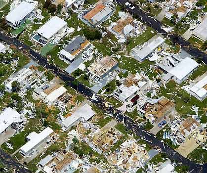
CAT4 damage
The forecast track runs directly through Mobile. Here is a picture of the aftermath of Hurricane Charley, a similar storm in wind speed.
Not only that, but you can expect to be without power for several weeks, no running water, no grocery stores, only the Red Cross lines for food. No gas stations, no money, no restaurants.
But to answer your question, a wobble is typical of hurricanes. They do not travel in a straight line. They are rotating and they don't form perfect circles. Think of your spinning washing machine when it isn't exactly balanced. It shakes and shimmies a lot. Same with the eye of a storm. It sort of wiggles and jigs on its route.
What needs to be watched is the path the storm takes over time. Seeing one or two frames having the eye a bit farther east is meaningless. Having the eye appear to move to the east over 12 hours is something else. Dennis has maintained a solid northwest trajectory since before it hit Cuba. The only turn it took was to the northwest, from due west over South America.
0 likes


-
wlfpack81

- Professional-Met

- Posts: 417
- Joined: Thu Sep 18, 2003 11:19 am
- Location: Arlington, VA
- Contact:
A note on the evac suggestion. I wouldn't go east as that'd put you in the ne-ern portion of the storm as you wouldn't be able to make the drive from Mobile over to say Jackonsville in time. Not to mention most roads (I-10 etc.) will probably shut down once winds get over 40mph or so.
If you have time to leave best thing would be to go west that way you'd stay on the left (weaker) side of the storm. However, if you and your family can't leave I'll have to stress with others that maybe you should find a shelter if possible, especially if you're along the coast. Mobile was lucky that Ivan went east of the city but with Dennis most models are somehwat coming into agreement with landfall very near Mobile or maybe just to the west. As one poster stated that would basically push Mobile Bay nw-ward into the city of Mobile!!! Nightmare scenario if that happened.
If you have time to leave best thing would be to go west that way you'd stay on the left (weaker) side of the storm. However, if you and your family can't leave I'll have to stress with others that maybe you should find a shelter if possible, especially if you're along the coast. Mobile was lucky that Ivan went east of the city but with Dennis most models are somehwat coming into agreement with landfall very near Mobile or maybe just to the west. As one poster stated that would basically push Mobile Bay nw-ward into the city of Mobile!!! Nightmare scenario if that happened.
0 likes
-
InshoreFanatic
- Tropical Low
- Posts: 27
- Joined: Sun Jul 10, 2005 1:08 am
-
dolebot_Broward_NW
- Category 2
- Posts: 529
- Joined: Fri Sep 10, 2004 6:38 am
Time to leave
Not joking at all, a good idea would be to make bracelets with your name, driver license number, SSN, religion so the emergency workers can more easily identify you. Duct tape your Last Will and Testament to your chest in a double zip-loc, and duct-taped bag.
Seriously...wake them up and go. If they don't go, save yourself.
Seriously...wake them up and go. If they don't go, save yourself.
0 likes
-
InshoreFanatic
- Tropical Low
- Posts: 27
- Joined: Sun Jul 10, 2005 1:08 am
Who is online
Users browsing this forum: pepecool20 and 82 guests