

The Nam for the last several runs has insisted that Dennis would move wnw/nw beginning this afternoon. Thus far it's performing very well. It's only out 24 hours but the method behind the madness and the current synoptic environment really does make sense...We'll see how the remaining run turns out.
http://www.nco.ncep.noaa.gov/pmb/nwprod ... loop.shtml
00z NAM continues trend of a significant FL Keys Threat
Moderator: S2k Moderators
Forum rules

The posts in this forum are NOT official forecasts and should not be used as such. They are just the opinion of the poster and may or may not be backed by sound meteorological data. They are NOT endorsed by any professional institution or STORM2K. For official information, please refer to products from the National Hurricane Center and National Weather Service.
Re: 00z NAM continues trend of a significant FL Keys Threat
Vortex wrote:The Nam for the last several runs has insisted that Dennis would move wnw/nw beginning this afternoon. Thus far it's performing very well. It's only out 24 hours but the method behind the madness and the current synoptic environment really does make sense...We'll see how the remaining run turns out.
http://www.nco.ncep.noaa.gov/pmb/nwprod ... loop.shtml
Some variation runs of the gfs pull a similar track...
http://moe.met.fsu.edu/cyclonephase/com ... 12/M3.html
-Eric
0 likes


-
jax
-
PurdueWx80
- Professional-Met

- Posts: 2720
- Joined: Fri Aug 13, 2004 8:33 pm
- Location: Madison, WI
- Contact:
I'm sorry, but we can't put any merit in a model that has too small a domain to even cover the initial location of the storm. This is why it handles Dennis so poorly. It will get better as we go through tomorrow (becasue the storm will be within the bounds of where the model is actually run at initialization), but for now all should be ignored. The NAM did such a wonderful job with Cindy because that storm actually formed will within the NAM's domain. The key point here is that the NAM is a mesoscale regional model that covers much of North America, whereas the GFS, ECMWF, UKMET and GEM are all global models, with domains that cover most/all of the planet.
0 likes


The key point here is that the NAM is a mesoscale regional model that covers much of North America
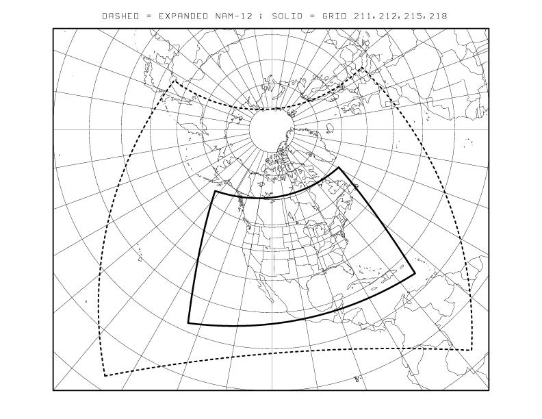
The dashed outline is the ETA/NAM domain. Hence, it isn't used for TC forecasting very often because the model is designed to predict weather on the North American continents. The limited domain lets the model be run at higher resolution, but as you probably noticed, a shorter duration (84 hours currently) before the boundary conditions catch up and forecast skill is lost.
The closer you are to the boundaries of the domain, the less useful the model. I would only use the NAM in the very near term.
0 likes
Who is online
Users browsing this forum: No registered users and 115 guests