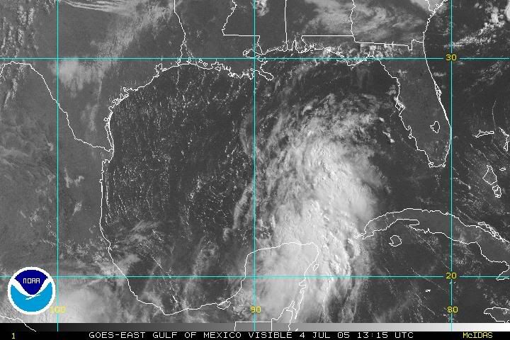
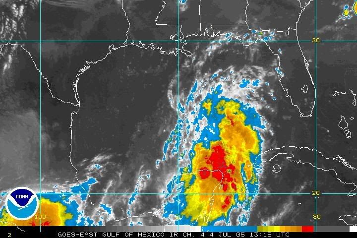
MLC has moved NNW taking over and well in command, lets see if it works to the surface.
http://www.ssd.noaa.gov/PS/TROP/DATA/RT ... -loop.html
System has split and looks to be heading NNW or NW..
Moderator: S2k Moderators
Forum rules

The posts in this forum are NOT official forecasts and should not be used as such. They are just the opinion of the poster and may or may not be backed by sound meteorological data. They are NOT endorsed by any professional institution or STORM2K. For official information, please refer to products from the National Hurricane Center and National Weather Service.
-
Guest
System has split and looks to be heading NNW or NW..
Last edited by Guest on Mon Jul 04, 2005 8:53 am, edited 2 times in total.
0 likes
-
Lowpressure

- S2K Supporter

- Posts: 2032
- Age: 58
- Joined: Sun Sep 14, 2003 9:17 am
- Location: Charlotte, North Carolina
-
Sean in New Orleans

- Category 5

- Posts: 1794
- Joined: Thu Aug 28, 2003 7:26 pm
- Location: New Orleans, LA 30.0N 90.0W
- Contact:
-
Sean in New Orleans
- Category 5
- Posts: 1794
- Joined: Thu Aug 28, 2003 7:26 pm
- Location: New Orleans, LA 30.0N 90.0W
- Contact:
-
Guest
No one will admit this system is gonna cause havoc for NOLA and Mississippi and Alabama and Florida Panhandle... thats right I said it, that dirty word of hurricane season FLORIDA! But it will mainly be a rain event for them (Florida).
Last edited by Guest on Mon Jul 04, 2005 8:59 am, edited 1 time in total.
0 likes

-
Air Force Met
- Military Met

- Posts: 4372
- Age: 56
- Joined: Tue Jul 08, 2003 9:30 am
- Location: Roan Mountain, TN
I believe that there is a piece of engery being spit out right now. This is bad in the short term, but in long run may be good for the system. Think back to yesterday when the MLC and LLC were disjointed...if you looked up towards the channel...there was another area of mid-level vorticity. I think this is the blob that is streaming north. Now...I think the MLC is sitting north of the yucatan...and the latest burst of convection should help this center consolidate.
0 likes
-
Opal storm
Yes,I know Texas needs the rain but it doesn't look like they will get it from this system,especially if it continues this NW/NNW track.Frederic1979 wrote:No one will admit this system is gonna cause havoc for NOLA and Mississippi and Alabama and Florida Panhandle... thats right I said it, that dirty word of hurricane season FLORIDA! But it will mainly be a rain event for them (Florida).
0 likes
-
Stratosphere747
- Category 5
- Posts: 3772
- Joined: Thu Sep 11, 2003 8:34 pm
- Location: Surfside Beach/Freeport Tx
- Contact:
Air Force Met wrote:I believe that there is a piece of engery being spit out right now. This is bad in the short term, but in long run may be good for the system. Think back to yesterday when the MLC and LLC were disjointed...if you looked up towards the channel...there was another area of mid-level vorticity. I think this is the blob that is streaming north. Now...I think the MLC is sitting north of the yucatan...and the latest burst of convection should help this center consolidate.
That would tend to push the track further east? If there is any track....
0 likes
-
Lowpressure
- S2K Supporter
- Posts: 2032
- Age: 58
- Joined: Sun Sep 14, 2003 9:17 am
- Location: Charlotte, North Carolina
-
Guest
Air Force Met wrote:I believe that there is a piece of engery being spit out right now. This is bad in the short term, but in long run may be good for the system. Think back to yesterday when the MLC and LLC were disjointed...if you looked up towards the channel...there was another area of mid-level vorticity. I think this is the blob that is streaming north. Now...I think the MLC is sitting north of the yucatan...and the latest burst of convection should help this center consolidate.
Good observation, I concur, uh I agree.
0 likes
-
feederband

- S2K Supporter
- Posts: 3423
- Joined: Wed Oct 01, 2003 6:21 pm
- Location: Lakeland Fl
-
Guest
Air Force Met wrote:I believe that there is a piece of engery being spit out right now. This is bad in the short term, but in long run may be good for the system. Think back to yesterday when the MLC and LLC were disjointed...if you looked up towards the channel...there was another area of mid-level vorticity. I think this is the blob that is streaming north. Now...I think the MLC is sitting north of the yucatan...and the latest burst of convection should help this center consolidate.
Good observation, I concur, uh I agree.
0 likes
-
HouTXmetro

- Category 5
- Posts: 3949
- Joined: Sun Jun 13, 2004 6:00 pm
- Location: District of Columbia, USA

HouTXmetro wrote:As I posted in another thread, based on the vis either one of the potential centers has more of a west-wnw heading now.
IMMO when this thing finally consolidates it probably head WNW to NW around the high to east. I'm puzzled as to what short wave diving SE out of the Plains will do to "CINDY"
0 likes
Who is online
Users browsing this forum: No registered users and 64 guests