000
ABNT20 KNHC 030229
TWOAT
TROPICAL WEATHER OUTLOOK
NWS TPC/NATIONAL HURRICANE CENTER MIAMI FL
1030 PM EDT SAT JUL 2 2005
FOR THE NORTH ATLANTIC...CARIBBEAN SEA AND THE GULF OF MEXICO...
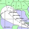
A LARGE AREA OF DISTURBED WEATHER OVER THE NORTHWESTERN CARIBBEAN
SEA HAS CONTINUED TO BECOME BETTER ORGANIZED BETWEEN 100 TO 200
MILES EAST OF THE YUCATAN PENINSULA AND BELIZE. UPPER-LEVEL WINDS
ARE ALSO BECOMING MORE FAVORABLE...AND A TROPICAL DEPRESSION COULD
DEVELOP OVER THE NEXT COUPLE OF DAYS AS THE SYSTEM MOVES
WEST-NORTHWESTWARD AT 10 TO 15 MPH. INTERESTS IN AND NEAR THE
NORTHWESTERN CARIBBEAN SEA...YUCATAN CHANNEL...THE SOUTHERN GULF OF
MEXICO...AND THE YUCATAN PENINSULA SHOULD CLOSELY MONITOR THE
PROGRESS OF THIS SYSTEM. SQUALLS PRODUCING LOCALLY HEAVY RAINFALL
AND GUSTY WINDS WILL BE POSSIBLE WITH SOME OF THE STRONGER
THUNDERSTORMS. AN AIR FORCE RESERVE RECONNAISSANCE AIRCRAFT IS
SCHEDULED TO INVESTIGATE THE SYSTEM ON SUNDAY...IF NECESSARY.
ELSEWHERE...TROPICAL STORM FORMATION IS NOT EXPECTED THROUGH MONDAY.
FORECASTER STEWART
$$
10:30 TWO
Moderator: S2k Moderators
Forum rules

The posts in this forum are NOT official forecasts and should not be used as such. They are just the opinion of the poster and may or may not be backed by sound meteorological data. They are NOT endorsed by any professional institution or STORM2K. For official information, please refer to products from the National Hurricane Center and National Weather Service.
-
swimaster20
- Category 1

- Posts: 285
- Joined: Tue Nov 23, 2004 2:41 pm
- Location: The Heart of Cajun Country
10:30 TWO
0 likes
-
cycloneye

- Admin

- Posts: 148870
- Age: 69
- Joined: Thu Oct 10, 2002 10:54 am
- Location: San Juan, Puerto Rico
No mention of the atlantic wave but I know they are looking closely at it.They are waiting for much more organization than what it is now and convection persistance.
0 likes
Visit the Caribbean-Central America Weather Thread where you can find at first post web cams,radars
and observations from Caribbean basin members Click Here
and observations from Caribbean basin members Click Here
-
Matt-hurricanewatcher
-
Derek Ortt
the fact that the carib wave they are mentioning is located according to Stewart just 100-200 miles offshore and is moving to the west at 10-15, leads me to believe no recon tomorrow as it will be inland. He mentions a couple of days before formation, meaning they are thinking GOM formation, as I am as well
0 likes
-
hurricanetrack

- HurricaneTrack.com

- Posts: 1781
- Joined: Tue Dec 02, 2003 10:46 pm
- Location: Wilmington, NC
- Contact:
-
senorpepr

- Military Met/Moderator

- Posts: 12542
- Age: 43
- Joined: Fri Aug 22, 2003 9:22 pm
- Location: Mackenbach, Germany
- Contact:
Derek Ortt wrote:the fact that the carib wave they are mentioning is located according to Stewart just 100-200 miles offshore and is moving to the west at 10-15, leads me to believe no recon tomorrow as it will be inland. He mentions a couple of days before formation, meaning they are thinking GOM formation, as I am as well
Yup, that's exactly what I got out of the outlook as well.
The 0Z models initalized the system moving at 29011KT. That will put it about 156 miles WNW of that position by 12Z tomorrow morning -- well inland. If that's the case, recon will be scrapped and the airmen may get another day to relax.
0 likes
-
Stormcenter
- S2K Supporter

- Posts: 6689
- Joined: Wed Sep 03, 2003 11:27 am
- Location: Houston, TX
Derek Ortt wrote:the fact that the carib wave they are mentioning is located according to Stewart just 100-200 miles offshore and is moving to the west at 10-15, leads me to believe no recon tomorrow as it will be inland. He mentions a couple of days before formation, meaning they are thinking GOM formation, as I am as well
Moving WNW per NHC 10:30pm update.
0 likes
-
Brent
- S2K Supporter
- Posts: 38678
- Age: 37
- Joined: Sun May 16, 2004 10:30 pm
- Location: Tulsa Oklahoma
- Contact:
Stormcenter wrote:Derek Ortt wrote:the fact that the carib wave they are mentioning is located according to Stewart just 100-200 miles offshore and is moving to the west at 10-15, leads me to believe no recon tomorrow as it will be inland. He mentions a couple of days before formation, meaning they are thinking GOM formation, as I am as well
Moving WNW per NHC 10:30pm update.
Still goes in over the Yucatan. Must move almost straight north to avoid it.
0 likes
#neversummer
-
*StOrmsPr*

- Tropical Storm

- Posts: 198
- Joined: Thu May 01, 2003 7:39 pm
- Location: Humacao,Puerto Rico
- Contact:


-
Hurricaneman

- Category 5
- Posts: 7404
- Age: 45
- Joined: Tue Aug 31, 2004 3:24 pm
- Location: central florida
Who is online
Users browsing this forum: No registered users and 59 guests