6-23-05 10:00 AM PDT TWO, Is CALVIN on the way?

This is the general tropical discussion area. Anyone can take their shot at predicting a storms path.

Moderator: S2k Moderators

Forum rules

The posts in this forum are NOT official forecasts and should not be used as such. They are just the opinion of the poster and may or may not be backed by sound meteorological data. They are NOT endorsed by any professional institution or STORM2K. For official information, please refer to products from the National Hurricane Center and National Weather Service.

Help Support Storm2K
Message
Author
User avatar
HURAKAN
Professional-Met
Professional-Met
Posts: 46086
Age: 38
Joined: Thu May 20, 2004 4:34 pm
Location: Key West, FL
Contact:

6-23-05 10:00 AM PDT TWO, Is CALVIN on the way?

#1 Postby HURAKAN » Thu Jun 23, 2005 12:13 pm

Tropical Weather Outlook


Statement as of 10:00 am PDT on June 23, 2005


For the eastern North Pacific...east of 140 degrees west longitude.
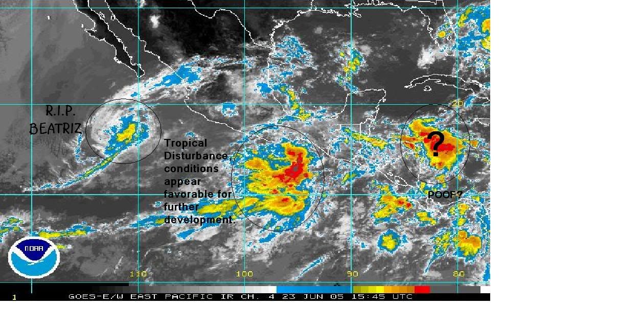
The National Hurricane Center is issuing advisories on Tropical
Storm Beatriz located about 415 miles south of the southern tip of
Baja California.

An area of disturbed weather has formed a few hundred miles south of
the Gulf of Tehuantepec. Conditions appear favorable for additional
slow development during the next day or two as the system moves
westward at 5 to 10 mph.
Elsewhere...tropical storm formation is not expected through
Friday.

Forecaster Knabb/Beven

Image
0 likes   

Scorpion

#2 Postby Scorpion » Thu Jun 23, 2005 12:22 pm

Oh great :roll: .
0 likes   

Brent
S2K Supporter
S2K Supporter
Posts: 38266
Age: 37
Joined: Sun May 16, 2004 10:30 pm
Location: Tulsa Oklahoma
Contact:

#3 Postby Brent » Thu Jun 23, 2005 12:35 pm

Boooooo. :grr: :grr: :grr:
0 likes   
#neversummer

User avatar
dhweather
S2K Supporter
S2K Supporter
Posts: 6199
Joined: Sat Aug 14, 2004 9:29 pm
Location: Heath, TX
Contact:

#4 Postby dhweather » Thu Jun 23, 2005 1:01 pm

Man, the EPAC is on the verge of going up 3-1
0 likes   

User avatar
Swimdude
Category 5
Category 5
Posts: 2270
Joined: Mon Jul 26, 2004 11:57 am
Location: Houston, TX

#5 Postby Swimdude » Thu Jun 23, 2005 1:20 pm

It isn't uncommon for the EPAC to have a running head start. Still, i'm irritated at lack of Atlantic activity. :x
0 likes   

User avatar
Hurricanehink
S2K Supporter
S2K Supporter
Posts: 2044
Joined: Sun Nov 16, 2003 2:05 pm
Location: New Jersey

#6 Postby Hurricanehink » Thu Jun 23, 2005 3:59 pm

Relax, it's June! We'll regain the lead in September or October when EPAC is more or less dead.
0 likes   

Matt-hurricanewatcher

#7 Postby Matt-hurricanewatcher » Thu Jun 23, 2005 4:03 pm

The cmc,MM5,Gfs is hinting at something. Could we have are C storm looks possible.
0 likes   

Matt-hurricanewatcher

#8 Postby Matt-hurricanewatcher » Thu Jun 23, 2005 4:09 pm

Ukmet


NEW TROPICAL STORM FORECAST TO DEVELOP AFTER 72 HOURS

FORECAST POSITION AT T+72 : 11.7N 97.0W


VERIFYING TIME POSITION STRENGTH TENDENCY

-------------- -------- -------- --------

12UTC 26.06.2005 11.7N 97.0W WEAK LITTLE CHANGE

00UTC 27.06.2005 11.8N 97.9W WEAK LITTLE CHANGE

12UTC 27.06.2005 12.6N 98.6W WEAK LITTLE CHANGE

00UTC 28.06.2005 12.6N 100.5W WEAK LITTLE CHANGE

12UTC 28.06.2005 12.6N 101.4W MODERATE INTENSIFYING SLIGHTLY

00UTC 29.06.2005 12.6N 103.2W MODERATE INTENSIFYING SLIGHTLY

12UTC 29.06.2005 13.5N 105.0W MODERATE INTENSIFYING SLIGHTLY


THIS INFORMATION IS PROVIDED AS GUIDANCE FOR TROPICAL CYCLONE

RSMCS. IT REQUIRES INTERPRETATION BY TROPICAL CYCLONE SPECIALISTS

AND SHOULD NOT BE CONSIDERED AS A FINAL PRODUCT
0 likes   

Matt-hurricanewatcher

#9 Postby Matt-hurricanewatcher » Thu Jun 23, 2005 6:03 pm

Can you say 3-1 soon!!!

http://www.ssd.noaa.gov/PS/TROP/DATA/RT/EPAC/IR4/20.jpg

000
ABPZ20 KNHC 232229
TWOEP
TROPICAL WEATHER OUTLOOK
NWS TPC/NATIONAL HURRICANE CENTER MIAMI FL
4 PM PDT THU JUN 23 2005

FOR THE EASTERN NORTH PACIFIC...EAST OF 140 DEGREES WEST LONGITUDE.

THE NATIONAL HURRICANE CENTER IS ISSUING ADVISORIES ON TROPICAL
STORM BEATRIZ LOCATED ABOUT 400 MILES SOUTH OF THE SOUTHERN TIP OF
BAJA CALIFORNIA.

AN AREA OF DISORGANIZED SHOWERS AND THUNDERSTORMS IS CENTERED A FEW
HUNDRED MILES SOUTH-SOUTHWEST OF THE GULF OF TEHUANTEPEC.
CONDITIONS APPEAR FAVORABLE FOR SLOW DEVELOPMENT OF THIS SYSTEM
DURING THE NEXT DAY OR TWO AS THE SYSTEM MOVES WESTWARD AT 5 TO 10
MPH.

ELSEWHERE...TROPICAL STORM FORMATION IS NOT EXPECTED THROUGH
FRIDAY.

FORECASTER FRANKLIN
0 likes   

whereverwx
Category 5
Category 5
Posts: 1109
Joined: Mon May 31, 2004 10:15 pm

#10 Postby whereverwx » Thu Jun 23, 2005 6:11 pm

Wow, well the Atlantic needs some cheerleaders, maybe that will tempt some development. If not, then we could always wait! :)
0 likes   

Brent
S2K Supporter
S2K Supporter
Posts: 38266
Age: 37
Joined: Sun May 16, 2004 10:30 pm
Location: Tulsa Oklahoma
Contact:

#11 Postby Brent » Thu Jun 23, 2005 6:22 pm

Forgot to add... last year the EPAC was up 4-0


and we all know how that season turned out. :eek:
0 likes   
#neversummer

User avatar
dhweather
S2K Supporter
S2K Supporter
Posts: 6199
Joined: Sat Aug 14, 2004 9:29 pm
Location: Heath, TX
Contact:

#12 Postby dhweather » Thu Jun 23, 2005 7:20 pm

Yeah, but that was last year. :lol: :lol:
0 likes   


Return to “Talkin' Tropics”

Who is online

Users browsing this forum: Google [Bot] and 86 guests