Possible Category 5 Hurricanes?
Moderator: S2k Moderators
Forum rules

The posts in this forum are NOT official forecasts and should not be used as such. They are just the opinion of the poster and may or may not be backed by sound meteorological data. They are NOT endorsed by any professional institution or STORM2K. For official information, please refer to products from the National Hurricane Center and National Weather Service.


-
vacanechaser

- Category 5

- Posts: 1461
- Joined: Wed Dec 03, 2003 9:34 pm
- Location: Portsmouth, Va
- Contact:
Brent wrote:The only known Cat 5's at landfall were the 1935 Keys Hurricane, Camille, and Andrew. This thread is about storms that reached Cat 5 at some point in that life like Isabel etc. but weakened before landfall.
I think he wants to make every hurricane a cat 5..
Jesse V. Bass III
http://www.vastormphoto.com
Hurricane Intercept Research Team
0 likes
-
vacanechaser
- Category 5
- Posts: 1461
- Joined: Wed Dec 03, 2003 9:34 pm
- Location: Portsmouth, Va
- Contact:
Matt-hurricanewatcher wrote:Also look at Ivan southwest of Jamaica. It looks like its eye is clouded. In while south of the Caymens it formed a double eyewall. (As I can remember)...


The eye being clouded over don't mean much to me. A lot of powerful hurricanes have their eyes cloud over during the daytime hours. Has something to do with the heating process if I am correct. But after the sun goes down most times, the eye will clear out once again. Remember Isabel had a clouded eye at a few points during her cat 5 stint.
Jesse V. Bass III
http://www.vastormphoto.com
Hurricane Intercept Research Team
0 likes
-
vacanechaser
- Category 5
- Posts: 1461
- Joined: Wed Dec 03, 2003 9:34 pm
- Location: Portsmouth, Va
- Contact:
Opal storm wrote:Brent wrote:I think Floyd was... if it did not become one, it was the closest one will ever come without being one.
The others I don't think so. Opal could have been(based on pressure), but the satellite looked horrible even at that stage(not even really looking like a 4, much less a borderline 5).
You can't judge a storm's strength by the way it looks.Charley a good example,looked more like a weak hurricane but was actually a very strong cat 4.
Whatever... Charley looked weak to you because you couldn't see an eye that well on satellite. Thats what happens when it is about 5 miles wide. The entire circulation was smaller than alot of hurricanes we have seen in the past few years. Plus Charley had that clouded eye look during the daytime hours. I was in the center of Charley when it pasted over, only small areas of blue could be seen.
Jesse V. Bass III
http://www.vastormphoto.com
Hurricane Intercept Research Team
0 likes
-
Anonymous
vacanechaser wrote:Brent wrote:The only known Cat 5's at landfall were the 1935 Keys Hurricane, Camille, and Andrew. This thread is about storms that reached Cat 5 at some point in that life like Isabel etc. but weakened before landfall.
I think he wants to make every hurricane a cat 5..
Jesse V. Bass III
http://www.vastormphoto.com
Hurricane Intercept Research Team
I take great offense to that. No, I just think Opal and Floyd may have been Cat 5's for a time.
0 likes
-
Brent
- S2K Supporter

- Posts: 38678
- Age: 37
- Joined: Sun May 16, 2004 10:30 pm
- Location: Tulsa Oklahoma
- Contact:
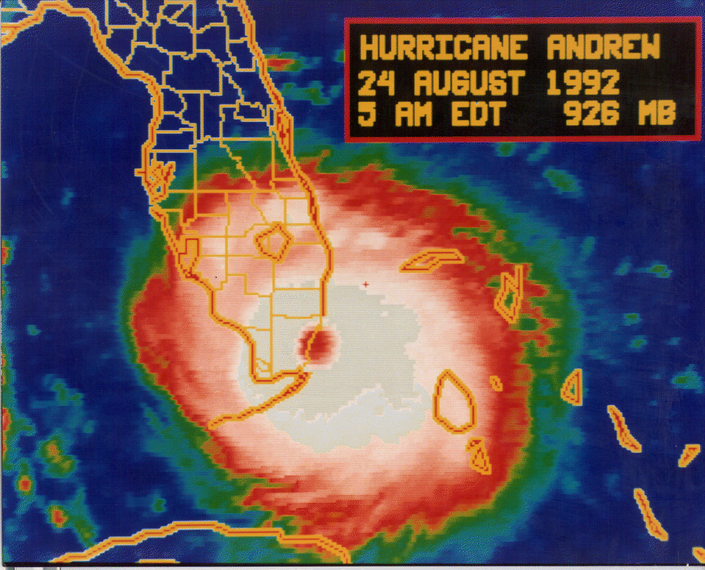
~Floydbuster wrote:Charley looked weak??
He looked like a Cat 2 to me. That's why I was so shocked when recon was out and it became a Strong 4 in a matter of minutes.
THIS looks like a borderline 4/5 and it's also compact:
http://www.nhc.noaa.gov/gifs/1992andy1.gif
0 likes
#neversummer
-
Hybridstorm_November2001

- S2K Supporter
- Posts: 2817
- Joined: Sat Aug 21, 2004 2:50 pm
- Location: SW New Brunswick, Canada
- Contact:
RE:
Floyd was a beautiful symmetrical storm, with a concentric ring of VERY deep convection around it's large well defined eye. In short it's satellite signature was most impressive indeed. As such, If Floyd was not 160 mph at peak strength East of the Bahamas, it was pretty damn close I would guess.
Hybridstorm_November2001
Hybridstorm_November2001
0 likes
-
cyclonaut

-
Bocadude85

- Category 5
- Posts: 2990
- Age: 39
- Joined: Mon Apr 18, 2005 2:20 pm
- Location: Honolulu,Hi
-
SouthernWx
Bocadude85 wrote:I wouldnt be surprised if the 1947 cane that hit around south palm beach was a cat 5 at landfall, 155mph sustained winds at pompano lighthouse.
Yes, but that was recorded on an anemometer atop a lighthouse 100' feet or more above the ground.....IMO sustained winds at the standard 10 m level (33') were closer to 135-140 mph (120 kts); based upon the central pressure of 940 mb, and the large size of the eyewall.
We today know (thanks to eyewall dropsondes) that winds in a severe hurricane are stronger a few hundred feet above the surface than either at the ground or at 5000' or 10,000' feet (850 or 700 mb flight level). That's one big concern hurricane experts have with people using "vertical evacuation" into beachfront buildings as a last resort.
If a 145 mph cat-4 moved inland at Miami Beach or Daytona....those unlucky enough to be stranded on the 20th floors of any tall beachfront condo or hotel could expect cat-5 intensity winds at that level; perhaps 165-170 mph winds...with even stronger gusts
PW
FYI......there was excellent recon info from both Opal and Floyd. Based upon this data, IMO both hurricanes maxed out as borderline cat-4/5 storms...135 kt (155 mph).
0 likes
-
SouthernWx
FYI...if anyone is interested, I recently created webpages with the most intense Atlantic hurricanes of record (by minimum central pressure and by estimated max sustained winds; plus a chart showing the lowest central pressures ever recorded by aircraft reconnisance in an Atlantic hurricane); also a webpage listing the most intense landfalling U.S. hurricanes of record since 1846.
These intensities are based on my thirty years of dedicated hurricane research, utilizing every shred of data I could find to create the most accurate database possible; including data by NHC, AOML/HRD, NOAA, old newspapers, analysis of damage photos; and interviews/ discussions between myself and former NHC forecasters, current and retired NWS meteorologists, and hurricane survivors.
My wind speed numbers on some past violent hurricanes may be different than data you'll find at Unisys, NHC, or other archived hurricane sites....but I've tried to find the true intensity of each hurricane, to the best of my ability (which means sometimes looking at the size of the hurricane to determine pressure gradient vs wind speed relationship).
You can access both webpages through either link:
http://community-2.webtv.net/SouthernWx61
http://community-2.webtv.net/SouthernWx61/Hurricane
PW
0 likes

Who is online
Users browsing this forum: No registered users and 44 guests