You can find the clouds moving around the system centered around 16 north/76 west. With convection moving around it to the northeast on the northeast side. Also look at the shear to the north as it moves north=Upper level high. The shear over this system is around 10 knots with moist air all around.
What do you think.
http://www.ssd.noaa.gov/PS/TROP/DATA/RT ... -loop.html
There seems to be the first signs of a spin
Moderator: S2k Moderators
Forum rules

The posts in this forum are NOT official forecasts and should not be used as such. They are just the opinion of the poster and may or may not be backed by sound meteorological data. They are NOT endorsed by any professional institution or STORM2K. For official information, please refer to products from the National Hurricane Center and National Weather Service.
-
Matt-hurricanewatcher
-
Matt-hurricanewatcher
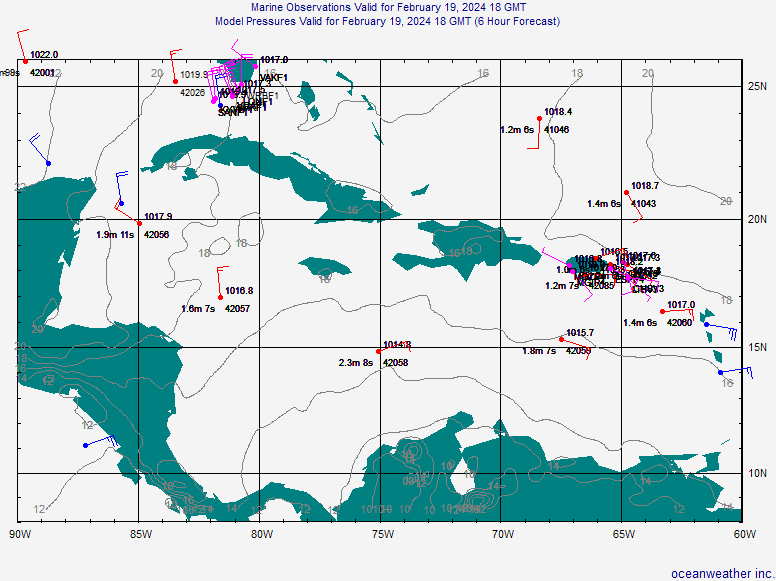
Wow its really getting interesting now. Take a look at the surface reports.
First press Caribbean then press the surface obs.
You will see that they kind of show a closed off wind field/Surface low.
http://www.oceanweather.com/data/
First press Caribbean then press the surface obs.
You will see that they kind of show a closed off wind field/Surface low.
http://www.oceanweather.com/data/
0 likes
-
HURAKAN

- Professional-Met

- Posts: 46086
- Age: 38
- Joined: Thu May 20, 2004 4:34 pm
- Location: Key West, FL
- Contact:
Matt-hurricanewatcher wrote:Wow its really getting interesting now. Take a look at the surface reports.
First press Caribbean then press the surface obs.
You will see that they kind of show a closed off wind field/Surface low.
http://www.oceanweather.com/data/
This one? Looks nice, let see what happens.
0 likes
-
Derek Ortt
there is absolutely no closed low.
I think I am speaking for <b>MANY</b> coastal residents with the following statement (maybe not many on the board here, but many at large
<b>MATT, STOP CHEERING FOR MORE DEVELOPMENT! IT ONLY BRINGS ABOUT MORE DEATH AND DESTRUCTION, WHICH WE HAVE HAD ENOUGH OF</b>
I think I am speaking for <b>MANY</b> coastal residents with the following statement (maybe not many on the board here, but many at large
<b>MATT, STOP CHEERING FOR MORE DEVELOPMENT! IT ONLY BRINGS ABOUT MORE DEATH AND DESTRUCTION, WHICH WE HAVE HAD ENOUGH OF</b>
0 likes
-
Matt-hurricanewatcher
Derek what the heck? I'm just showing buoys in other things trying to see if there is anything. More then I can see for many a member. In two this is a weather board so yes thats what we do is watch to see for development. 
In plus it is not my falt people build there house on the coast. So why should I care? I say get use to them or move away from the coast.
In plus it is not my falt people build there house on the coast. So why should I care? I say get use to them or move away from the coast.
0 likes
-
Derek Ortt
-
Matt-hurricanewatcher
I'm sorry derek, I don't went to see people get hurt or killed but tropical cyclones are here to stay. I would be happy with no strong storms this year but alot of weak ones or fish.
Thats what I'v trying to say that there was a low pressure even so a disoreganized one. That is a start in every system has a start....Now lets watch in see.
I have alot of respect for you in really do look up to you.
Thats what I'v trying to say that there was a low pressure even so a disoreganized one. That is a start in every system has a start....Now lets watch in see.
I have alot of respect for you in really do look up to you.
0 likes
-
crazycajuncane

- S2K Supporter

- Posts: 1097
- Joined: Sun Aug 15, 2004 2:51 pm
- Location: Lafayette, Louisiana
- Contact:
With pleasure comes pain. The risk of living on the water means one day you could be swimming in it.
I feel horrible for the people in Alabama and Florida from Hurricane Ivan. I hope they have several years of no hurricanes so they can rebuild, but like my friend told me... if you build that close to the water you take a big risk.
I feel horrible for the people in Alabama and Florida from Hurricane Ivan. I hope they have several years of no hurricanes so they can rebuild, but like my friend told me... if you build that close to the water you take a big risk.
0 likes
-
Anonymous
Derek Ortt wrote:there is absolutely no closed low.
I think I am speaking for <b>MANY</b> coastal residents with the following statement (maybe not many on the board here, but many at large
<b>MATT, STOP CHEERING FOR MORE DEVELOPMENT! IT ONLY BRINGS ABOUT MORE DEATH AND DESTRUCTION, WHICH WE HAVE HAD ENOUGH OF</b>
I do not think he is cheering for more development. He cannot control the weather anymore than you can Derek. We all respect your opinion on things Derek especially when you explain not judge. I know it is frustrating but this is a weather board. Get some rest we will all need you soon enough.
0 likes
-
Anonymous
Derek Ortt wrote:there is absolutely no closed low.
I think I am speaking for <b>MANY</b> coastal residents with the following statement (maybe not many on the board here, but many at large
<b>MATT, STOP CHEERING FOR MORE DEVELOPMENT! IT ONLY BRINGS ABOUT MORE DEATH AND DESTRUCTION, WHICH WE HAVE HAD ENOUGH OF</b>
Matt can Cheer and wishcast all he wants but mother nature is the one in control here. Matt does not cause death and destruction, mother nature does and I am sure she is not at all listenning to Matt! So please, give Matt a break! We very much value you as a met but we have hurricane fans here who have no control of the weather but always wish and no--mother nature does not listen to our wishes!
0 likes
-
Matt-hurricanewatcher
My friends I'm not -removed- or cheering anything on. What I'm doing is looking at the data. In seeing that there a developing disoreganized area of low pressure at or around the surface. Also with 84 to 85 degree water over the most prime area for development this time of year. With shear less then 10 knots. I'm stating facts in backing them up with buoys. I don't need to wishcast to give what I think. I look at the information first...
I do not wish a strong hurricane on no one. But I do as a weather person went to see what a hurricane can or can't do. In believe me there is likely some stuff we don't know. Only 150 or so years of data. In which only the last 45 years is soild??? In with that time there has been seasons that would make 2004 look like a normal season. Just think of the season we don't know about over the last 500 years. Out of your dreams I mean 30 storm season could of happen. Is that based on facts no. Could it have happen very much so. So we really know what can happen?
I don't wish death on any one. I don't control weather...The only one that doe's is are lord. What more to say is it is a wait in see.
0 likes

Do not see a spin Matt a little early if at all.One thing I have to comment on I think you brought up earlier was the lack of shear.I did not expect to see the Sub Tropical jet escape till late June or mid-July.Low pressures,lack of shear,and warm ST's we are getting into a more favorable conditions for sure.
0 likes
-
Derek Ortt
-
Anonymous
Derek Ortt wrote:ok everyone
check the water vapor loops
the large upper low is actually dropping into the Caribbean now. Maybe our beloved global models have butchered yet another upper wind forecast. Perhaps its time for satellite winds to have a higher weighting in the model analysis
I dont see it---The upper low is headed for the Bahamas and UL winds around the ULL are lifting out of the caribbean as evident here.... http://hadar.cira.colostate.edu/ramsdis ... _ls_0.html
0 likes
-
Matt-hurricanewatcher
I see what derek sees. It is starting ever so slowly the band of strong wind/shear is moving south around 78 west. The shear max is just north of Hati 40 knots. I think it will move west-southwestward while another upper high builds into the central caribbean around 70 west.(Which is the lowing of the shear levels over south america around that area)
So I think that shear levels over the system should increase to near 15 knots over the next 12 hours. Then another Upper level high should build over the system afterwards. The upper low shown by the nam model is the system we track after 24 hours with a closed surface low as it moves northeastward. Believe me I don't think this upper low will develop. I will post the model soon.
Here is the shear map
http://cimss.ssec.wisc.edu/tropic/real- ... g8shr.html
Now to 18 hours
http://www.nco.ncep.noaa.gov/pmb/nwprod ... 18_m.shtml
18 to 42 hours
http://www.nco.ncep.noaa.gov/pmb/nwprod ... 42_m.shtml
0 likes
-
Derek Ortt

Pressure dropped 1 full mb last hour at 42057. This is of substance, because of when it happpened. This was beyond the normal dirunal cycle of the last 5 days (the largest 1 hour fall in 5 days). 1007.3mb
2mb pressure falls over 24 hours
http://www.ndbc.noaa.gov/show_plot.php?station=42058&meas=pres&uom=M
2mb pressure falls over 24 hours
http://www.ndbc.noaa.gov/show_plot.php?station=42058&meas=pres&uom=M
0 likes

Who is online
Users browsing this forum: cycloneye, Google [Bot], Google Adsense [Bot] and 65 guests