Personal Discussion of 01L (Graphic Issues Resolved)

This is the general tropical discussion area. Anyone can take their shot at predicting a storms path.

Moderator: S2k Moderators

Forum rules

The posts in this forum are NOT official forecasts and should not be used as such. They are just the opinion of the poster and may or may not be backed by sound meteorological data. They are NOT endorsed by any professional institution or STORM2K. For official information, please refer to products from the National Hurricane Center and National Weather Service.

Help Support Storm2K
Message
Author
DoctorHurricane2003

Personal Discussion of 01L (Graphic Issues Resolved)

#1 Postby DoctorHurricane2003 » Wed Jun 08, 2005 7:49 pm

S2K Disclaimer: The following post is NOT an official forecast and should not be used as such. It is just the opinion of the poster and may or may not be backed by sound meteorological data. It is NOT endorsed by any professional institution including storm2k.org For Official Information please refer to the NHC and NWS products.

Personal Disclaimer: All official products are located at http://www.nhc.noaa.gov/ . For warning and evacuation information, please turn to your local NWS office website via a link at http://www.srh.noaa.gov/ or tune in to your local television station.

Graphic Disclaimer: The Graphic provided in this forecast is not official in any way and not endorsed by S2K, NWS, or NOAA.

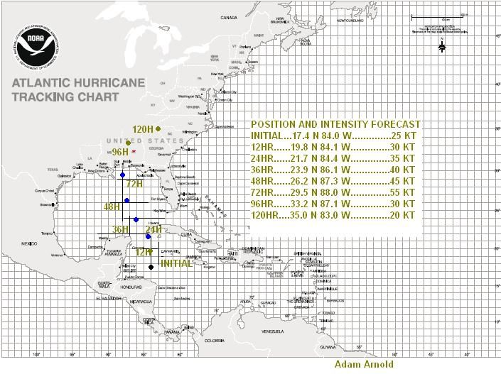
This discussion will be very brief. Currently, 01L is a very weak depression with a broad low-level circulation, and is moving north slowly. I expect that the high will build in further into the E GOM and that will steer 01L on a N-NNW-NW-NNW-N type path. Environmental conditions also appear as though they will be favorable for further intensification through to the coastline. There is an outside chance that 01L could briefly reach hurricane status, but that is not expected, and is quite far out into the future to have any certainty. I expect landfall near Mobile, AL in approximately 80 hours as a strong tropical storm. If you have any questions, please feel free to ask!

01L. Position and Intensity Forecast Graphic, 08.06.2005:

Note: The actual position of the storm can vary at 72 hours by as much as 125 miles in either direction, and the strength can vary by as much as 20 KT. The information on the graphic is provided as a best estimate.

Image

I apologize for the image difficulties!
0 likes   

DoctorHurricane2003

#2 Postby DoctorHurricane2003 » Wed Jun 08, 2005 8:09 pm

bumped so people see the enlarged graphic :)
0 likes   

User avatar
Agua
Category 5
Category 5
Posts: 1138
Joined: Thu Jul 31, 2003 4:54 pm
Location: Biloxi, Mississippi

#3 Postby Agua » Wed Jun 08, 2005 8:24 pm

Hope you're right and it goes in east of us.
0 likes   

User avatar
GulfBreezer
Category 5
Category 5
Posts: 2230
Joined: Wed Oct 09, 2002 8:58 pm
Location: Gulf Breeze Fl
Contact:

#4 Postby GulfBreezer » Wed Jun 08, 2005 8:26 pm

Agua wrote:Hope you're right and it goes in east of us.


BITE YOUR TONGUE! :)
0 likes   

Matt-hurricanewatcher

#5 Postby Matt-hurricanewatcher » Wed Jun 08, 2005 8:28 pm

I say weak tropical storm if it makes it.
0 likes   


Return to “Talkin' Tropics”

Who is online

Users browsing this forum: AnnularCane, kevin and 571 guests