WTNT 21 KNGU 081800
SUBJ/TROPICAL CYCLONE FORMATION ALERT 081800Z JUN 05//
RMKS/
1. FORMATION OF A TROPICAL CYCLONE IS POSSIBLE WITHIN
100 NM EITHER SIDE OF A LINE FROM 16.0N7 83.8W9 TO 21.4N7 85.6W9
WITHIN THE NEXT 24 HOURS. AVAILABLE DATA DOES NOT JUSTIFY
ISSUANCE OF NUMBERED TROPICAL CYCLONE WARNINGS AT THIS TIME.
2. A 1004MB LOW CENTERED NEAR THE COASTAL BORDER OF HONDURAS/
NICARAGUA IS MOVING NORTH-NORTHWEST AT ABOUT 10 KNOTS. A SURFACE
TROUGH EXTENDS FROM THIS LOW ACROSS WESTERN CUBA AND INTO THE
FLORIDA STRAITS. SCATTEROMETRY WINDS PLACE A VERY WEAK CENTER OF
CIRCULATION NEAR 12N 82W. CONDITIONS IN THE UPPER ATMOSPHERE ARE
BECOMING FAVORABLE FOR FURTHER DEVELOPMENT WITH ANTICYCLONIC
CIRCULATION AT 200MB, A CLOSED LOW IN THE LOWER LEVELS, AND LESS
THAN 10 KNOTS OF SHEAR. ALONG THE PROJECTED PATH, CONDITIONS FOR
INTENSIFICATION CONTINUE TO IMPROVE OVER THE NEXT FEW DAYS.
SYSTEM MOVEMENT FORECAST IS NORTH-NORTHWEST THROUGH THE NEXT 72
HOURS. SEA SURFACE TEMPERATURE ANALYZED FROM SATELLITE DATA IS
84F(29C).
3. THIS ALERT WILL BE REISSUED, UPGRADED TO WARNING OR CANCELLED BY 091800Z8.
//
This is getting very interesting hour by hour.
Tropical Cyclone Formation Alert
Moderator: S2k Moderators
Forum rules

The posts in this forum are NOT official forecasts and should not be used as such. They are just the opinion of the poster and may or may not be backed by sound meteorological data. They are NOT endorsed by any professional institution or STORM2K. For official information, please refer to products from the National Hurricane Center and National Weather Service.
-
cycloneye

- Admin

- Posts: 148872
- Age: 69
- Joined: Thu Oct 10, 2002 10:54 am
- Location: San Juan, Puerto Rico
Tropical Cyclone Formation Alert
Last edited by cycloneye on Wed Jun 08, 2005 2:27 pm, edited 1 time in total.
0 likes
Visit the Caribbean-Central America Weather Thread where you can find at first post web cams,radars
and observations from Caribbean basin members Click Here
and observations from Caribbean basin members Click Here
-
x-y-no

- Category 5

- Posts: 8359
- Age: 65
- Joined: Wed Aug 11, 2004 12:14 pm
- Location: Fort Lauderdale, FL
SCATTEROMETRY WINDS PLACE A VERY WEAK CENTER OF
CIRCULATION NEAR 12N 82W.
Well, that's significantly further east than I thought ...
And 12N? Something is screwy.
Last edited by x-y-no on Wed Jun 08, 2005 1:57 pm, edited 1 time in total.
0 likes
-
PTrackerLA

- Category 5
- Posts: 5281
- Age: 42
- Joined: Thu Oct 10, 2002 8:40 pm
- Location: Lafayette, LA
-
Dave C
- S2K Supporter

- Posts: 868
- Joined: Thu Sep 04, 2003 4:36 pm
- Location: Middleboro, Mass.(midway between Cape Cod and Boston)
yea
Yesterday you could see the T storms being pushed ne by the upper-winds. Today the storms appear to be remaining near the general region of low-pressure. Should be very interesting next several days 
0 likes
-
Dave C
- S2K Supporter
- Posts: 868
- Joined: Thu Sep 04, 2003 4:36 pm
- Location: Middleboro, Mass.(midway between Cape Cod and Boston)
yea
Yesterday you could see the T storms being pushed ne by the upper-winds. Today the storms appear to be remaining near the general region of low-pressure. Should be very interesting next several days
0 likes

-
cycloneye
- Admin
- Posts: 148872
- Age: 69
- Joined: Thu Oct 10, 2002 10:54 am
- Location: San Juan, Puerto Rico
x-y-no wrote:Sheesh ... check the date.
EDIT:
Urgh ... never mind ... I'm just goofy ...
081800Z JUN 05//
08 is there.
0 likes
Visit the Caribbean-Central America Weather Thread where you can find at first post web cams,radars
and observations from Caribbean basin members Click Here
and observations from Caribbean basin members Click Here
-
george_r_1961

- S2K Supporter
- Posts: 3171
- Age: 64
- Joined: Sat Oct 12, 2002 9:14 pm
- Location: Carbondale, Pennsylvania

LOL
Haha! Yes, that product is a few days old. 
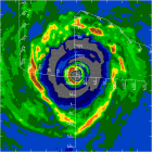
But staying on this topic, looking at the visible, the low level clouds are still moving about a broad circulation centered around 16.5N, 85W. But what I am thinking might happen as the atmosphere becomes more favorable: A new center will form on the eastern side of this broad circulation about 250 km NNE of the Honduras/Nicaragua, or roughly 17N, 82W, where, on occasion in the visible, you can see a circulation in the low and mid levels. This is also where thunderstorms seem to be more persistant. But this is only speculation on my part. Keep in mind larger circulation is so broad, something better could turn up anywhere north of Honduras over the next 24-36 hours. And it is certainly going to help having recon in there to investigate all that chaos.
But staying on this topic, looking at the visible, the low level clouds are still moving about a broad circulation centered around 16.5N, 85W. But what I am thinking might happen as the atmosphere becomes more favorable: A new center will form on the eastern side of this broad circulation about 250 km NNE of the Honduras/Nicaragua, or roughly 17N, 82W, where, on occasion in the visible, you can see a circulation in the low and mid levels. This is also where thunderstorms seem to be more persistant. But this is only speculation on my part. Keep in mind larger circulation is so broad, something better could turn up anywhere north of Honduras over the next 24-36 hours. And it is certainly going to help having recon in there to investigate all that chaos.
0 likes

-
x-y-no
- Category 5
- Posts: 8359
- Age: 65
- Joined: Wed Aug 11, 2004 12:14 pm
- Location: Fort Lauderdale, FL
Re: LOL
Windspeed wrote:Haha! Yes, that product is a few days old.
Actually, it isn't. I'm just goofy.
But staying on this topic, looking at the visible, the low level clouds are still moving about a broad circulation centered around 16.5N, 85W. But what I am thinking might happen is as the atmosphere becomes more favorable, a new center will form on the eastern side of this broad circulationabout 250 km NNE of the Honduras/Nicaragua, or roughly 17N, 82W, where, on occasion in the visible, you can see a circulation in the low and mid levels. This is also where thuderstorms seem to be more persistant. But this is only speculation on my part. Keep in mind larger circulation is so broad, something better could turn up anywhere north of Honduras over the next 24-36 hours. And it is certainly going to help having recon in there to investigate all that chaos.
Looks to me like we have a broad low-level circulation at around 17N 83.5W or so and a mid-level circulation east of that. I'm thinking the two are trying to get stacked, which could happen a bit northeast of where the broad LLC is now.
Jan
0 likes
-
cycloneye
- Admin
- Posts: 148872
- Age: 69
- Joined: Thu Oct 10, 2002 10:54 am
- Location: San Juan, Puerto Rico
SUBJ/TROPICAL CYCLONE FORMATION ALERT 081800Z JUN 05//
WTNT 21 KNGU 081800
REF/A/RMG/NAVLANTMETOCCEN NORFOLK VA/081800Z JUN 05//
AMPN/REF IS TROPICAL CYCLONE FORMATION ALERT (WTNT21 KNGU 081800)//
RMKS/
1. FORMATION OF A SIGNIFICANT TROPICAL CYCLONE IS POSSIBLE WITHIN
100 NM EITHER SIDE OF A LINE FROM 15.9N5 83.8W9 TO 21.4N7 85.6W9
WITHIN THE NEXT 00 TO 24 HOURS. AVAILABLE DATA DOES NOT JUSTIFY
ISSUANCE OF NUMBERED TROPICAL CYCLONE WARNINGS AT THIS TIME.
WINDS IN THE AREA ARE ESTIMATED TO BE 20 TO 24 KNOTS. METSAT IM
AGERY AT 081800Z7 INDICATES THAT A CIRCULATION CENTER IS LOCATED
NEAR 16.0N7 83.8W9. THE SYSTEM IS MOVING NORTH-NORTHWESTWARD AT
10 KNOTS.
2. REMARKS:
THIS SUPERSEDES REF A.
A 1004MB LOW CENTERED NEAR THE COASTAL BORDER OF HON
DURAS/NICARAGUA IS MOVING NORTH-NORTHWEST AT ABOUT 10 KNOTS. A
SURFACE TROUGH EXTENDS EXTENDS FROM THIS LOW ACROSS WESTERN CUBA
AND INTO THE FLORIDA STRAITS. SCATTEROMETRY WINDS PLACE A VERY
WEAK CENTER OF CIRCULATION NEAR 12N 82W. CONDITIONS IN THE UPPER
ATMOSPHERE ARE BECOMING FAVORABLE FOR FURTHER DEVELOPMENT WITH
ANTI-CYCLONIC CIRCULATION AT 200MB, A CLOSED LOW IN THE LOWER
LEVELS, AND LESS THEN 10 KNOTS OF SHEAR. A TROPICAL WAVE NEAR 81W
SOUTH OF 17N MOVING WEST AT 10 KNOTS WILL COMBINE WITH THE LOW
ENHANCING THE DEVELOPMENT OF THIS SYSTEM. ALONG THE PROJECTED
PATH, CONDITIONS FOR INTENSIFICATION CONTINUE TO IMPROVE OVER THE
NEXT FEW DAYS. SYSTEM MOVEMENT FORECAST IS NORTH-NORTHWESTWARD
THROUGH THE NEXT 72 HOURS. SEA SURFACE TEMPERATURE ANALYZED FROM
SATELITE DATA IS 84F(29C).
3. THIS ALERT WILL BE REISSUED, UPGRADED TO WARNING OR CANCELLED BY 091800Z8.
//
BT
They expanded the alert text from the one that is at the first post of thread.
0 likes
Visit the Caribbean-Central America Weather Thread where you can find at first post web cams,radars
and observations from Caribbean basin members Click Here
and observations from Caribbean basin members Click Here

Who is online
Users browsing this forum: Google Adsense [Bot] and 78 guests