The University of South Alabama meteorology department continues to do research on exactly how strong Ivan was. By closely examining all the radar data, they have discovered several intense core collapses in the eatern eyewall that brought down the most violent winds of the storm. In fact, a sailboat that was anchored in Wolf Bay (extreme southeast Baldwin County Alabama) clocked a wind of 150mph before it was incapcitated.
They are becoming more confident of the fact that Ivan was a much stronger than previously thought. Research is ongoing.
Was Ivan a Category 4?
Moderator: S2k Moderators
Forum rules

The posts in this forum are NOT official forecasts and should not be used as such. They are just the opinion of the poster and may or may not be backed by sound meteorological data. They are NOT endorsed by any professional institution or STORM2K. For official information, please refer to products from the National Hurricane Center and National Weather Service.
-
ALhurricane

- Professional-Met

- Posts: 452
- Joined: Wed Jan 08, 2003 12:46 pm
- Location: Daphne, AL
Was Ivan a Category 4?
0 likes
-
vbhoutex

- Storm2k Executive

- Posts: 29141
- Age: 74
- Joined: Wed Oct 09, 2002 11:31 pm
- Location: Cypress, TX
- Contact:
Rainband wrote:Interesting. That would explain the catastrophic damage
That would explain the catastrophic damage that can't be attributed to storm surge. I have seen scenes of destruction in Pensacola that I know are not from surge since I know their location and I don't think Cat2 winds did what I saw.
Please keep us posted on this ongoing research.
0 likes


.
Posted: Sat Jun 04, 2005 2:46 pm Post subject: ALSO...
--------------------------------------------------------------------------------
Thank you for the reminder and if anyone is interested, Jim Cantorie is gonna be Live off and on tomorrow starting at 7:00AM Eastern/maybe 6:00 central time from Pensacola and Pensacola Beach.
http://www.pensacolanewsjournal.com/lif ... 608C.shtml
Weather Channel’s Jim Cantore to broadcast live from the beach
June 4, 2005
The Weather Channel's Jim Cantore will be broadcasting live from Pensacola Beach on Sunday as part of the channel's Hurricane Week next week.
Last year will be remembered as the costliest hurricane season ever. Even as some are still recovering, the 2005 hurricane season is upon us.
To help draw awareness to the season and the importance of storm preparation, The Weather Channel is presenting Hurricane Week, a special programming event.
Hurricane Week kicks off at 7 a.m. Sunday with live reports throughout the day from veteran meteorologist Cantore on-location in Pensacola.
The live coverage will culminate at 7 p.m. with "Season of Suspense," a new, one-hour program with Cantore as host. The program will feature a 2005 hurricane season outlook from hurricane expert Dr. Steve Lyons.
"Season of Suspense" spotlights compelling stories from last year's hurricane season. Some highlights:
· The harrowing tale of a couple who are trapped in the attic of their home on Pensacola Bay by the rising water during Hurricane Ivan.
· A hurricane chaser and photographer's story of his ordeal pinned in the streets of Punta Gorda by the ferocity of Hurricane Charley.
· The story of dozens of terrified evacuees who ride out the storm in a baseball stadium as Hurricane Frances brings the park's light poles crashing to the ground.
· The story of a group of women and their dedication to rebuilding the home of a mother of three who was left homeless by Hurricane Ivan.
The rest of Hurricane Week will feature episodes of "Storm Stories" each night. At 7 p.m. Monday, "Storm Stories" will feature Grande Lagoon.
Details: full schedule at http://www.weather.com/newscenter/stormstories/
©The Pensacola News Journal
June 4, 2005
0 likes
-
Derek Ortt
the sailboat observation has already been documented to have been at roughly 200 feet. The 10m winds are only about 80% of those, which indicate minimal cat 3 intensity.
Also, those enhanced streaks do not represent the maximum sustained winds. If they did, Andrew would have been about a 180KT cane, as that was the winds within the streaks.
One also needs to know the exact elevation of the doppler radar winds. If they were at 250 feet, the same 80% reduction also applies
Remember in Lenny, the dropsondes measured about 185KT at 950mb, which is suggestive of 130KT surface winds (for the eye wall with a surface pressure of 980mb)
0 likes
-
Derek Ortt
-
Matt-hurricanewatcher
-
MGC

- S2K Supporter

- Posts: 5940
- Joined: Sun Mar 23, 2003 9:05 pm
- Location: Pass Christian MS, or what is left.
That would have to be some sailboat to have a 200 foot mast. The mainmast of the USCG Barque Eagle (which I toured in Mobile in 2002) is only 147 feet. I doubt the 150mph sailboat report. In that kind of wind the sailboat was likely knocked down or beached by the surge and or high winds. With all the dry air Ivan was sucking in at the time of landfall Ivan was lucky to be a minimun Cat 3. I saw the damage first hand several months after Ivan. One must consider the intensity and duration of the wind. A 100mph cat 2 wind over a considerable period of time can and will do great damage.......MGC
0 likes
-
AussieMark

- Category 5

- Posts: 5858
- Joined: Tue Sep 02, 2003 6:36 pm
- Location: near Sydney, Australia
-
weatherSnoop

- S2K Supporter
- Posts: 702
- Age: 63
- Joined: Wed Oct 09, 2002 10:06 pm
- Location: Tampa, FL
- Contact:
-
Derek Ortt
not only was Ivan sucking in loads of dry air, it was encountering 30KT of shear, plus, it encountered the cold north GOM water.
At landfall, it was weakening as fast as Lili was before it hit Louisiana. The difference with Ivan was that it started to weaken just 6 hours before landfall, where Lili started to weaken 12 hours prior
At landfall, it was weakening as fast as Lili was before it hit Louisiana. The difference with Ivan was that it started to weaken just 6 hours before landfall, where Lili started to weaken 12 hours prior
0 likes
-
gatorcane

- S2K Supporter
- Posts: 23706
- Age: 48
- Joined: Sun Mar 13, 2005 3:54 pm
- Location: Boca Raton, FL
Derek, I wouldn't say the water was cold but it certainly wasn't as warm as the waters a couple of hundred miles south. Jean and Frances both caused significant upwelling especially in the Northeastern GOM. I agree with you that Ivan does not deserve CAT 4 status...winds of even 90 mph like you said can do significant damage....CAT 3 winds are very destructive.
0 likes
Derek Ortt wrote:not only was Ivan sucking in loads of dry air, it was encountering 30KT of shear, plus, it encountered the cold north GOM water.
At landfall, it was weakening as fast as Lili was before it hit Louisiana. The difference with Ivan was that it started to weaken just 6 hours before landfall, where Lili started to weaken 12 hours prior
I think this is the Key factor! Cat 3 Winds But a Cat 4 Maybe even 5 in some areas in regards to TIDAL SURGE! In other words the winds Started Decreasing But the surge was still Built high by previous cat 4 winds...Make Sense?
0 likes
-
ALhurricane
- Professional-Met
- Posts: 452
- Joined: Wed Jan 08, 2003 12:46 pm
- Location: Daphne, AL
With all due respect Derek, the people at the University of South Alabama aren't attempting to do anything of the sort that you claim. I never said they were claiming it as a Cat 4 right now, but they believe that it may have been stronger than what the official word is. They are legitimate meteorologist researching the storm. It does them no good to hype up the storm more than it was. Dr. Keith Blackwell, one of the professors at USA, is well respected in the field and I certainly respect his ongoing work.
0 likes
-
vbhoutex
- Storm2k Executive
- Posts: 29141
- Age: 74
- Joined: Wed Oct 09, 2002 11:31 pm
- Location: Cypress, TX
- Contact:
Derek, I do not understand why you discount ANYONES opionion or thoughts on what winds could have been in any particular storm. This thread was simply started stating that the NWS in Mobile was continuing to look into it and you turn it into saying it is someone trying to make Ivan into something he wasn't. Since that person has been working for NWS for a few years now I do put credence in his word.
0 likes
-
Anonymous
Of the things I have seen--pictures, videos including Mark Sudduth's, and stories as well as the NHC's and local NWS obsevations (reccon, radar, satellite, land obserations), I see no reason to believe that Ivan was anything near the magnitude of the monstorous storm named Charley---That video that Mark shot in charley under the overpass was absolutely amazing and I was in some disbelief he was actually able to contain himself as I would have probably freaked! Ivan was devastating-yes it was- MAJOR Coastal flooding and they lost the I-10 bridge! But I trust todays technology and Yes they revised Andrew 13 years ago to a cat 5 but the NHC and NWS have come a long way since then 
0 likes

-
HurricaneBill
- Category 5
- Posts: 3420
- Joined: Sun Apr 11, 2004 5:51 pm
- Location: East Longmeadow, MA, USA
Derek Ortt wrote:what this is, is yet another attempt to state that Ivan was stronger than it actually was. This is the result of people having absolutely no clue as to what upper cat 2/lower cat 3 winds could do. All they needed to do was look at Hatteras in 2003, when 90KT winds destroyed half of the town
Derek, I respect you and admire you. However, when somebody offers a differing opinion or something, you always seem to shoot it down as if they have no idea what they are talking about.
It's always "elevation was too high", "radar didn't show that", "people often overestimate wind speeds" or "that was probably flight level winds". It's always something.
In response to a poster asking why a reanalysis is being done, you said because back then, many times the sustained winds were "worthless estimates".
Now, seeing as in the 1950s and 1960s, we did not know as much as we do now about hurricanes, I think meteorologists did the best they could, even if they were just "worthless estimates" to you.
I know hurricane intensity is your forte, but show some respect! You are not the know-all and end-all in debating a hurricane's intensity.
There are people on this forum besides you who might actually know what they're talking about.
We're not all a bunch of Greatones, Derek. Some of us may not be professional mets, but we're not idiots either.
0 likes
-
Derek Ortt
my point is, this phenomenon has been documented in the forms of mini-swirls. The research is wonderful in documenting this fact with Ivan, but it does not suggest that Ivan was more than 100-105KT. They tend to be jumping to conclusions here. I also was told by an NHC forecaster than many wanted to only put Ivan at 100KT, less than the 105KT it is currently at, primarily based upon SFMR data and H-Wind.
I am somewhat familiar with the re-analysis project and have seen winds changed by up to 30KT. The initial estimates just do not hold any credence, plus, there are some problems regarding the changes when there is no data in the core.
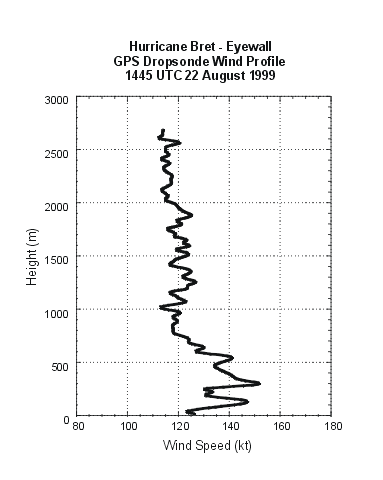
The height of the wind recordings is so critical
http://www.nhc.noaa.gov/prelims/1999bret4.gif
notice that at about 250 feet, the winds are between 145 and 150KT, but at the surface, only 125KT could be supported. Therefore, even if the doppler did record 135KT winds, 105KT at the surface would still be appropriate based upon the documented results of the dropsonde data (Franklin et al, 2003)
I am somewhat familiar with the re-analysis project and have seen winds changed by up to 30KT. The initial estimates just do not hold any credence, plus, there are some problems regarding the changes when there is no data in the core.
The height of the wind recordings is so critical
http://www.nhc.noaa.gov/prelims/1999bret4.gif
notice that at about 250 feet, the winds are between 145 and 150KT, but at the surface, only 125KT could be supported. Therefore, even if the doppler did record 135KT winds, 105KT at the surface would still be appropriate based upon the documented results of the dropsonde data (Franklin et al, 2003)
0 likes
Who is online
Users browsing this forum: Hurricane2022 and 60 guests