Adrian re-classified???

This is the general tropical discussion area. Anyone can take their shot at predicting a storms path.

Moderator: S2k Moderators

Forum rules

The posts in this forum are NOT official forecasts and should not be used as such. They are just the opinion of the poster and may or may not be backed by sound meteorological data. They are NOT endorsed by any professional institution or STORM2K. For official information, please refer to products from the National Hurricane Center and National Weather Service.

Help Support Storm2K
Message
Author
Brent
S2K Supporter
S2K Supporter
Posts: 38266
Age: 37
Joined: Sun May 16, 2004 10:30 pm
Location: Tulsa Oklahoma
Contact:

Adrian re-classified???

#1 Postby Brent » Wed Jun 01, 2005 8:54 pm

TWC(don't ask :lol: ) just said that Adrian has been re-classified as a TD landfall in El Salvador instead of a hurricane. WHAT THE HECK??? :eek: Anyone know if that's true?
0 likes   
#neversummer

User avatar
HURAKAN
Professional-Met
Professional-Met
Posts: 46086
Age: 38
Joined: Thu May 20, 2004 4:34 pm
Location: Key West, FL
Contact:

#2 Postby HURAKAN » Wed Jun 01, 2005 8:59 pm

NOT A TOTAL SURPRISE TO HEAR THAT FROM THE WEATHER CHANNEL.
0 likes   

HurricaneBill
Category 5
Category 5
Posts: 3420
Joined: Sun Apr 11, 2004 5:51 pm
Location: East Longmeadow, MA, USA

#3 Postby HurricaneBill » Wed Jun 01, 2005 9:04 pm

Well, Adrian did look pretty poor at landfall. However, I think downgrading Adrian to a TD is too extreme. I think Adrian was probably a moderate TS at landfall.
0 likes   

User avatar
mobilebay
Category 5
Category 5
Posts: 1853
Age: 51
Joined: Wed Aug 18, 2004 1:22 am
Location: Mobile, Alabama

#4 Postby mobilebay » Wed Jun 01, 2005 9:07 pm

It is true. Check the May summary at NHC website. They say it made landfall as a TD. :D
Last edited by mobilebay on Wed Jun 01, 2005 9:14 pm, edited 1 time in total.
0 likes   

User avatar
senorpepr
Military Met/Moderator
Posts: 12542
Age: 43
Joined: Fri Aug 22, 2003 9:22 pm
Location: Mackenbach, Germany
Contact:

#5 Postby senorpepr » Wed Jun 01, 2005 9:12 pm

mobilebay wrote:It is true. Check the May summary at NHC website. They sis say it made landfall as a TD. :D


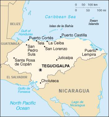
A POST-STORM ANALYSIS INDICATES THAT ADRIAN DID NOT MAKE LANDFALL AS
A HURRICANE IN EL SALVADOR EARLY ON THE 20TH... AS ASSESSED
OPERATIONALLY. BASED ON EXAMINATION OF SATELLITE DATA AND SURFACE
OBSERVATIONS... INCLUDING SHIP DATA OBTAINED AFTER THE EVENT... IT
HAS BEEN DETERMINED THAT ADRIAN WEAKENED OFFSHORE... WITH THE
CENTER MOVING EASTWARD EARLY ON THE 20TH AND ENTERING THE GULFO DE
FONSECA... JUST EAST OF EL SALVADOR... AS A TROPICAL DEPRESSION.
THE DEPRESSION THEN MADE LANDFALL ON THE PACIFIC COAST OF HONDURAS
DURING THE EVENING OF THE 20TH.
0 likes   

User avatar
HURAKAN
Professional-Met
Professional-Met
Posts: 46086
Age: 38
Joined: Thu May 20, 2004 4:34 pm
Location: Key West, FL
Contact:

#6 Postby HURAKAN » Wed Jun 01, 2005 9:17 pm

SORRY, BUT I'M IN SHOCK, I WAS NOT EXPECTING THIS.
0 likes   

User avatar
mobilebay
Category 5
Category 5
Posts: 1853
Age: 51
Joined: Wed Aug 18, 2004 1:22 am
Location: Mobile, Alabama

#7 Postby mobilebay » Wed Jun 01, 2005 9:18 pm

I just don't understand the wind gust they received at 83MPH. It was listed on a Public advisory just before landfall. I'm not second guessing anyone, but I have never seen a Depression produce a wind gust like that. :roll: :roll:
0 likes   

User avatar
mobilebay
Category 5
Category 5
Posts: 1853
Age: 51
Joined: Wed Aug 18, 2004 1:22 am
Location: Mobile, Alabama

#8 Postby mobilebay » Wed Jun 01, 2005 9:22 pm

Never mind. That was a Ham radio report. It was 81MPH not 83. Sorry. :oops: :oops:
0 likes   

Brent
S2K Supporter
S2K Supporter
Posts: 38266
Age: 37
Joined: Sun May 16, 2004 10:30 pm
Location: Tulsa Oklahoma
Contact:

#9 Postby Brent » Wed Jun 01, 2005 9:22 pm

That is unbelievable. :eek:

I thought for sure it was a strong tropical storm(65-70 mph) with the 83 mph gust.
0 likes   
#neversummer

tallywx
Category 2
Category 2
Posts: 798
Joined: Thu Jul 03, 2003 10:19 am
Location: Raleigh/Durham, NC

#10 Postby tallywx » Wed Jun 01, 2005 9:23 pm

So much for Adrian not making it across the mountains. It couldn't even make it across...83F waters!
0 likes   

User avatar
dhweather
S2K Supporter
S2K Supporter
Posts: 6199
Joined: Sat Aug 14, 2004 9:29 pm
Location: Heath, TX
Contact:

#11 Postby dhweather » Wed Jun 01, 2005 9:49 pm

tallywx wrote:So much for Adrian not making it across the mountains. It couldn't even make it across...83F waters!


:lol: :lol: :lol:
0 likes   

Derek Ortt

#12 Postby Derek Ortt » Wed Jun 01, 2005 10:08 pm

ok ok ok

the Pacific coast of Honduras... you do know that the center either crossed a pininsula first, or was half onshore and half off for many hours. It still affected el sal;vador as a strong ts
0 likes   

User avatar
mobilebay
Category 5
Category 5
Posts: 1853
Age: 51
Joined: Wed Aug 18, 2004 1:22 am
Location: Mobile, Alabama

#13 Postby mobilebay » Wed Jun 01, 2005 10:12 pm

It says above that it hit or was just east of el Salvador as a Tropical Depression. I did not see one word that evens suggest it hit any land area as a Tropical storm. Also, it said Adrian weakened OFFSHORE not partially on land. Just my opinion, Derek. That was even TWC's interpretation.
0 likes   

User avatar
Andrew92
S2K Supporter
S2K Supporter
Posts: 3247
Age: 41
Joined: Mon Jun 16, 2003 12:35 am
Location: Phoenix, Arizona

#14 Postby Andrew92 » Wed Jun 01, 2005 10:19 pm

mobilebay wrote:It says above that it hit or was just east of el Salvador as a Tropical Depression. I did not see one word that evens suggest it hit any land area as a Tropical storm. Also, it said Adrian weakened OFFSHORE not partially on land. Just my opinion, Derek. That was even TWC's interpretation.


TWC can be taken with a bit of a grain of salt. :wink:
0 likes   

Brent
S2K Supporter
S2K Supporter
Posts: 38266
Age: 37
Joined: Sun May 16, 2004 10:30 pm
Location: Tulsa Oklahoma
Contact:

#15 Postby Brent » Wed Jun 01, 2005 10:21 pm

Derek Ortt wrote:ok ok ok

the Pacific coast of Honduras... you do know that the center either crossed a pininsula first, or was half onshore and half off for many hours. It still affected el sal;vador as a strong ts


Look at a map... it didn't make sense to me either. There's a nice bay that is NOT in El Salvador... it borders Honduras and Nicaragua. The center went over that(was weakened by the mountains) and officially made landfall as a depression.
0 likes   
#neversummer

User avatar
mobilebay
Category 5
Category 5
Posts: 1853
Age: 51
Joined: Wed Aug 18, 2004 1:22 am
Location: Mobile, Alabama

#16 Postby mobilebay » Wed Jun 01, 2005 10:21 pm

Andrew92 wrote:
mobilebay wrote:It says above that it hit or was just east of el Salvador as a Tropical Depression. I did not see one word that evens suggest it hit any land area as a Tropical storm. Also, it said Adrian weakened OFFSHORE not partially on land. Just my opinion, Derek. That was even TWC's interpretation.


TWC can be taken with a bit of a grain of salt. :wink:

OK. Fair enough. But did you see anything in there that suggests it hit ANY land area as a Tropical Storm? In fact, the word was never used. :D
0 likes   

Matt-hurricanewatcher

#17 Postby Matt-hurricanewatcher » Wed Jun 01, 2005 10:33 pm

Bs just before landfall Andrian had formed a banding eye again. It was with out quastion a 75 to 80 mph hurricane. Storms that move in at that angle normally get a little stronger as they go in. Because of the angle of the land that tightens the cirualtion up.
0 likes   

User avatar
mobilebay
Category 5
Category 5
Posts: 1853
Age: 51
Joined: Wed Aug 18, 2004 1:22 am
Location: Mobile, Alabama

#18 Postby mobilebay » Wed Jun 01, 2005 10:35 pm

Once again, everyone knows more than the experts at the NHC. :roll: I thought we would at least make until July. :x
Last edited by mobilebay on Wed Jun 01, 2005 10:36 pm, edited 1 time in total.
0 likes   

User avatar
HURAKAN
Professional-Met
Professional-Met
Posts: 46086
Age: 38
Joined: Thu May 20, 2004 4:34 pm
Location: Key West, FL
Contact:

#19 Postby HURAKAN » Wed Jun 01, 2005 10:36 pm

Image

A clear map showing the Gulf of Fonseca.
0 likes   

Matt-hurricanewatcher

#20 Postby Matt-hurricanewatcher » Wed Jun 01, 2005 10:37 pm

What the heck Mobile they did report a 81 mph gust. In remember there is not many reporting stations down in that area. Why are you pointing fingers at me?
0 likes   


Return to “Talkin' Tropics”

Who is online

Users browsing this forum: bird and 584 guests