Initial Thoughts on TS Adrian Following Crossover

This is the general tropical discussion area. Anyone can take their shot at predicting a storms path.

Moderator: S2k Moderators

Forum rules

The posts in this forum are NOT official forecasts and should not be used as such. They are just the opinion of the poster and may or may not be backed by sound meteorological data. They are NOT endorsed by any professional institution or STORM2K. For official information, please refer to products from the National Hurricane Center and National Weather Service.

Help Support Storm2K
Message
Author
donsutherland1
S2K Analyst
S2K Analyst
Posts: 2718
Joined: Mon Sep 15, 2003 8:49 pm
Location: New York

Initial Thoughts on TS Adrian Following Crossover

#1 Postby donsutherland1 » Tue May 17, 2005 11:33 pm

Earlier, I had noted:

This system, if it survives the trek across Central America, will probably pass to the south and east of Florida. However, there is some possibility that it or its remnants could move across southwestern Florida.

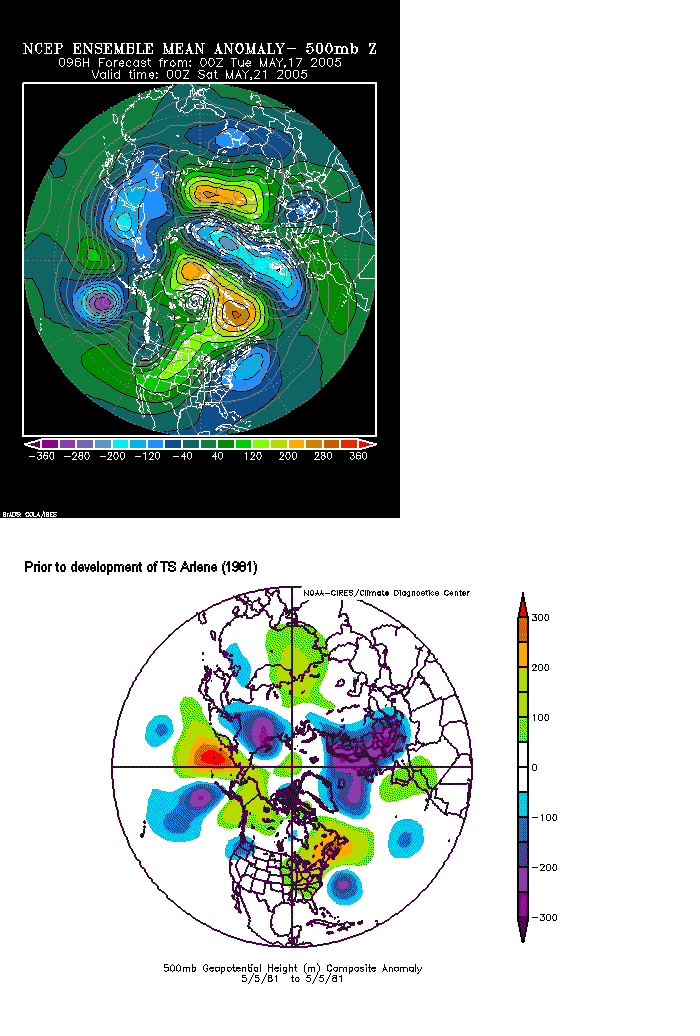
Right now, if I had to choose a reasonable candidate for a possible analog storm--for an approximate track--it would probably be Tropical Storm Arlene (1981):

Image

The 500 mb height anomalies forecast by the GFS ensembles and those that preceded the development of Arlene are somewhat similar:

Image

Given the GFS ensembles, a track somewhat to the left of Arlene's might be in order.

Early estimates for the possible approach toward Florida/Florida Straits:

20.0N 82.5W
21.0N 79.3W
22.0N 77.4W


Pursuant to the latest guidance, these ideas remain in relatively good shape at this point.
0 likes   

donsutherland1
S2K Analyst
S2K Analyst
Posts: 2718
Joined: Mon Sep 15, 2003 8:49 pm
Location: New York

Re: Initial Thoughts on TS Adrian Following Crossover

#2 Postby donsutherland1 » Wed May 18, 2005 8:20 am

Overnight, Tropical Storm Adrian continued to track to the Northeast. At this stage, the hurricane models are in close agreement as to Adrian's near-term track.

For those who are interested as to whether systems crossing from the eastern Pacific to the Caribbean/Gulf of Mexico have ever regenerated into at least tropical storm status, Tropical Storm #1 (1965) formed as a tropical depression in the eastern Pacific and later became a tropical storm in the Gulf of Mexico.

It should be noted that the synoptic situation then was quite different from the present one. The only thing I wanted to note is that it is not impossible for such systems to regenerate into named storms. Right now it remains to be seen how well Adrian will survive its journey across land. At this time, as far as the track goes, the analog from last night still appears to provide some good guidance.
0 likes   

cyclonaut

#3 Postby cyclonaut » Wed May 18, 2005 8:52 am

Hmm that May 81 storm was also named Arlene. 8-)

It seems to be moving more E/NE than NE @ this time(Thats how it looks to me on satellite)..It should bypass Florida to the south but it could mean more heavy rains for PR if this east trend continues.
0 likes   

User avatar
dhweather
S2K Supporter
S2K Supporter
Posts: 6199
Joined: Sat Aug 14, 2004 9:29 pm
Location: Heath, TX
Contact:

#4 Postby dhweather » Wed May 18, 2005 8:55 am

Don - great historical analysis!
0 likes   

User avatar
cajungal
Category 5
Category 5
Posts: 2336
Age: 49
Joined: Sun Mar 14, 2004 9:34 pm
Location: Schriever, Louisiana (60 miles southwest of New Orleans)

#5 Postby cajungal » Wed May 18, 2005 9:00 am

It won't survive the trip over Central America. The mountains will break it up. This a weak system to begin with. The US has nothing to worry about on this one.
0 likes   

User avatar
dhweather
S2K Supporter
S2K Supporter
Posts: 6199
Joined: Sat Aug 14, 2004 9:29 pm
Location: Heath, TX
Contact:

#6 Postby dhweather » Wed May 18, 2005 9:03 am

Oh, I agree - the terrain will slaughter the core of the system.
And if it does make it across, I think the remains will go through
the Carribean and out to sea in the Atlantic.
0 likes   

soonertwister
Category 5
Category 5
Posts: 1091
Joined: Mon Jun 16, 2003 2:52 pm

#7 Postby soonertwister » Wed May 18, 2005 9:34 am

I think that if Adrian stays south of Honduras then it won't be as disrupted by the terrain as if he goes across more to the north. The Sierra Madres peter out a little bit as you go south from Mexico, and they aren't terribly high. The highest mountains of Nicaragua are in the north, and the highest elevation in the country is right about 8,000 feet.

If the core of the storm goes south of those taller mountains, I think it will remain a TS. Anywhere north of there would be iffy, IMO. And he's projected to go north, so the storm very well may not survive the terrain.
0 likes   

User avatar
gatorcane
S2K Supporter
S2K Supporter
Posts: 23703
Age: 47
Joined: Sun Mar 13, 2005 3:54 pm
Location: Boca Raton, FL

#8 Postby gatorcane » Wed May 18, 2005 9:40 am

Don, didn't you mean southeastern FL in you initial post...?
0 likes   

donsutherland1
S2K Analyst
S2K Analyst
Posts: 2718
Joined: Mon Sep 15, 2003 8:49 pm
Location: New York

#9 Postby donsutherland1 » Wed May 18, 2005 9:41 am

Cyclonaut,

FWIW, since the naming of Atlantic tropical cyclones began, there have been 8 cases in which a storm was named "Arlene:" 1959, 1963, 1967, 1971, 1981, 1987, 1993, and 1999.
0 likes   

donsutherland1
S2K Analyst
S2K Analyst
Posts: 2718
Joined: Mon Sep 15, 2003 8:49 pm
Location: New York

#10 Postby donsutherland1 » Wed May 18, 2005 9:44 am

Boca_chris,

I probably should have stated that there's a small chance that it might cut across southern Florida. Given the synoptic situation, I don't believe that it would turn back toward the Florida Peninsula, though some early storms have turned back toward the U.S. Mainland in different setups.
0 likes   

donsutherland1
S2K Analyst
S2K Analyst
Posts: 2718
Joined: Mon Sep 15, 2003 8:49 pm
Location: New York

#11 Postby donsutherland1 » Wed May 18, 2005 9:48 am

Cajungal,

I'm not sure that Adrian will remain a tropical depression much less a tropical storm after crossing land. Overall, I believe this storm or its remnants will likely pass to the south and east of Florida. There's a small chance that they could cross southern Florida. However, I believe the former idea is much more likely and all that I have seen through mid-morning suggests that this remains the case.
0 likes   

donsutherland1
S2K Analyst
S2K Analyst
Posts: 2718
Joined: Mon Sep 15, 2003 8:49 pm
Location: New York

#12 Postby donsutherland1 » Wed May 18, 2005 9:49 am

Thanks dhweather.
0 likes   

User avatar
Zadok
Tropical Storm
Tropical Storm
Posts: 232
Joined: Sun Aug 29, 2004 7:32 am
Location: USA East Coast

#13 Postby Zadok » Wed May 18, 2005 9:51 am

It looks like Accuweather has is heading towards the other side of Cuba.

Image[/img]
0 likes   

User avatar
skysummit
S2K Supporter
S2K Supporter
Posts: 5305
Age: 49
Joined: Tue Aug 31, 2004 11:09 pm
Location: Ponchatoula, LA
Contact:

#14 Postby skysummit » Wed May 18, 2005 9:54 am

Well, that map is surely interesting. I wonder where their thoughts are coming from?
0 likes   

donsutherland1
S2K Analyst
S2K Analyst
Posts: 2718
Joined: Mon Sep 15, 2003 8:49 pm
Location: New York

#15 Postby donsutherland1 » Wed May 18, 2005 10:16 am

Zadok,

It's very early in the game as far as where the storm tracks once it enters the Caribbean. I believe it will track somewhat to the left of the path taken by Arlene (1981) and gave some coordinates. From that map, it's too soon to tell where AccuWx would track it once it gets into the Caribbean.

I like something closer to the Arlene (1981) track given the similar synoptic setups. However, there was a June storm that formed at 19.4N 83.6W and turned due north and north-northwestward:

Image
0 likes   

cyclonaut

#16 Postby cyclonaut » Wed May 18, 2005 10:57 am

donsutherland1;

I know there have been many Arlenes but the possibility of this being the 2nd May Arlene is interesting..I don't think there have been 2 May Atlantic storms with the same name before..

Having said that there is no guarantee this will even get a name once in the Caribbean..Its got a lot of obstacles to overcome.
0 likes   

donsutherland1
S2K Analyst
S2K Analyst
Posts: 2718
Joined: Mon Sep 15, 2003 8:49 pm
Location: New York

#17 Postby donsutherland1 » Wed May 18, 2005 11:22 am

Cyclonaut,

FWIW, May 1959 and May 1981 both had a storm named Arlene. Arlene is the only name used twice in May. May has not had 3 storms with the same name.

June, July and August each had 2 storms named Arlene, as well. The record number of storms with the same name in a month is 6: Florence in September.
0 likes   

LarryWx
S2K Supporter
S2K Supporter
Posts: 6854
Joined: Sun Sep 07, 2003 2:04 pm
Location: GA

#18 Postby LarryWx » Wed May 18, 2005 11:29 am

cyclonaut wrote:donsutherland1;

I know there have been many Arlenes but the possibility of this being the 2nd May Arlene is interesting..I don't think there have been 2 May Atlantic storms with the same name before.


IF it survives intact as a closed surface low, I've been told that it would retain the name of Adrian per today's S2K thread on the subject. You can see the thread at the following link:

http://www.storm2k.org/phpbb2/viewtopic.php?t=62584
0 likes   
Personal Forecast Disclaimer:
The posts in this forum are NOT official forecasts and should not be used as such. They are just the opinion of the poster and may or may not be backed by sound meteorological data. They are NOT endorsed by any professional institution or storm2k.org. For official information, please refer to the NHC and NWS products.

rainstorm

#19 Postby rainstorm » Wed May 18, 2005 11:36 am

wasnt 81 a slow season? maybe a good sign
0 likes   

cyclonaut

#20 Postby cyclonaut » Wed May 18, 2005 11:52 am

So it has happened already with 2 storms with the same name in May...& Arlene no less..Shouldve checked Unysis more thouroughly. :)

Thanks for the info Don.
0 likes   


Return to “Talkin' Tropics”

Who is online

Users browsing this forum: Google Adsense [Bot], Iceresistance, riapal, WaveBreaking and 590 guests