SST'S and Anomalies in Atlantic and Pacific

This is the general tropical discussion area. Anyone can take their shot at predicting a storms path.

Moderator: S2k Moderators

Forum rules

The posts in this forum are NOT official forecasts and should not be used as such. They are just the opinion of the poster and may or may not be backed by sound meteorological data. They are NOT endorsed by any professional institution or STORM2K. For official information, please refer to products from the National Hurricane Center and National Weather Service.

Help Support Storm2K
Message
Author
User avatar
cycloneye
Admin
Admin
Posts: 146216
Age: 69
Joined: Thu Oct 10, 2002 10:54 am
Location: San Juan, Puerto Rico

#81 Postby cycloneye » Wed May 04, 2005 5:13 pm

cycloneye wrote:Image


Image


Image


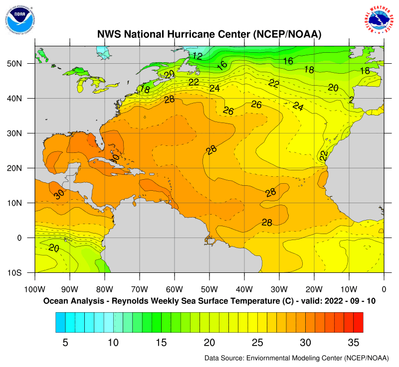
The GOM waters are starting to warm as it is expected but in a slow pace at this time.The Gulfstream waters still are cool but some signs of warming are there but not in a fast pace.The Caribbean sea is very warm in all the areas and the Tropical Atlantic is very warm from 40w to 60w south of 20n.


The MDR area in the Tropical Atlantic is warming a bit more than in the past 3 weeks.Also the COA area has anomalys going up to +3.0c.On contrast the coolest area in the Atlantic are the Gulfstream waters off the east coast and in the Gulf Of Mexico especially in the northern area of the GOM.Also in parts of the western atlantic near the Bahamas are still cool.


Image
0 likes   
Visit the Caribbean-Central America Weather Thread where you can find at first post web cams,radars
and observations from Caribbean basin members Click Here

User avatar
LSU2001
S2K Supporter
S2K Supporter
Posts: 1711
Age: 57
Joined: Sat Sep 11, 2004 11:01 pm
Location: Cut Off, Louisiana

#82 Postby LSU2001 » Wed May 04, 2005 9:50 pm

I keep trying to post images but only seem to get red x's.
anyway this link shows bouy data off the La. coast in the gulf. It follows very closely with the data on the maps previously posted.

http://www.ndbc.noaa.gov/station_page.php?station=spll1

TIm
0 likes   
Personal Forecast Disclaimer:
The posts in this forum are NOT official forecast and should not be used as such. They are NOT endorsed by any professional institution or storm2k.org. For official information, please refer to the NHC and NWS products.

User avatar
cycloneye
Admin
Admin
Posts: 146216
Age: 69
Joined: Thu Oct 10, 2002 10:54 am
Location: San Juan, Puerto Rico

#83 Postby cycloneye » Thu May 05, 2005 6:12 pm

I will keep this thread up in the first page as this theme is one of the most important factors that will create plenty of tropical activity especially in the Caribbean and East of the Lesser Antilles.
0 likes   
Visit the Caribbean-Central America Weather Thread where you can find at first post web cams,radars
and observations from Caribbean basin members Click Here

User avatar
cycloneye
Admin
Admin
Posts: 146216
Age: 69
Joined: Thu Oct 10, 2002 10:54 am
Location: San Juan, Puerto Rico

#84 Postby cycloneye » Fri May 06, 2005 2:46 pm

In my years as a tropical weather fan I haved never seen this very warm Atlantic Basin especially the Tropical Atlantic and the Caribbean Sea in early May.It may be compared with 1995 sst's data and that is scary. :eek:
0 likes   
Visit the Caribbean-Central America Weather Thread where you can find at first post web cams,radars
and observations from Caribbean basin members Click Here

Scorpion

#85 Postby Scorpion » Fri May 06, 2005 2:49 pm

I think the situation with above average SST's in the central Atlantic and below average near the coast is perfect for hurricane season. We can get nice powerful storms that fall apart right before shore so it lessens the impact.

But Scorpion eventually those waters off the east coast will warm when July,August and September arrive.However if it mantains relativily below average then yes it will help to weaken systems that may try to get to the US from the Atlantic but if they warm as normally happens then it will be another story for the East coast.
0 likes   

User avatar
cycloneye
Admin
Admin
Posts: 146216
Age: 69
Joined: Thu Oct 10, 2002 10:54 am
Location: San Juan, Puerto Rico

#86 Postby cycloneye » Fri May 06, 2005 2:57 pm

Scorpion wrote:I think the situation with above average SST's in the central Atlantic and below average near the coast is perfect for hurricane season. We can get nice powerful storms that fall apart right before shore so it lessens the impact.


But Scorpion eventually those waters off the east coast will warm when July,August and September arrive.However if it mantains relativily below average then yes it will help to weaken systems that may try to get to the US from the Atlantic but if they warm as normally happens then it will be another story for the East coast.
0 likes   
Visit the Caribbean-Central America Weather Thread where you can find at first post web cams,radars
and observations from Caribbean basin members Click Here

User avatar
cycloneye
Admin
Admin
Posts: 146216
Age: 69
Joined: Thu Oct 10, 2002 10:54 am
Location: San Juan, Puerto Rico

#87 Postby cycloneye » Mon May 09, 2005 1:59 pm

Image

In the updated grafic as of May 7th above of the anomalys in the Atlantic it shows some cooling of the waters off Western Africa which were at around +3.0c last week.But the MDR area continues very warm.In contrast look how cool the anomalys are at the GOM and especially off the East Coast of the US.

Image

In the grafic above updated as of May 7th the 26c line or the 80*F line is way more north in the Atlantic being early to mid May especially off Western Africa above 10n between 15-20w where it is more north for being this time of the year.
0 likes   

krysof

#88 Postby krysof » Mon May 09, 2005 2:05 pm

What is the difference between sst anomalys and temperatures, I never got what it meant.
0 likes   

User avatar
James
Category 5
Category 5
Posts: 1531
Joined: Tue Aug 24, 2004 10:29 am
Location: Gloucestershire, England
Contact:

#89 Postby James » Mon May 09, 2005 2:08 pm

I always thought that SST anomalies dealt with how above or below average the water temperatures are for that time of year.
0 likes   

User avatar
cycloneye
Admin
Admin
Posts: 146216
Age: 69
Joined: Thu Oct 10, 2002 10:54 am
Location: San Juan, Puerto Rico

#90 Postby cycloneye » Mon May 09, 2005 2:10 pm

krysof wrote:What is the difference between sst anomalys and temperatures, I never got what it meant.


Anomalys refer to where current temps are in comparison to their normals for the current time of year. SST's are the temperatures of the water at the surface.
0 likes   
Visit the Caribbean-Central America Weather Thread where you can find at first post web cams,radars
and observations from Caribbean basin members Click Here

cyclonaut

#91 Postby cyclonaut » Mon May 09, 2005 2:17 pm

cycloneye wrote:
Scorpion wrote:I think the situation with above average SST's in the central Atlantic and below average near the coast is perfect for hurricane season. We can get nice powerful storms that fall apart right before shore so it lessens the impact.


But Scorpion eventually those waters off the east coast will warm when July,August and September arrive.However if it mantains relativily below average then yes it will help to weaken systems that may try to get to the US from the Atlantic but if they warm as normally happens then it will be another story for the East coast.

Could'nt have said it better Cycloneye!

Those waters will warm up by the time the meat of the season gets here.

These same SSTs that are cool now will be above normal within a few month.
0 likes   

krysof

#92 Postby krysof » Mon May 09, 2005 6:58 pm

Well if that's so, then the waters of the EC is way below normal.
0 likes   

User avatar
cycloneye
Admin
Admin
Posts: 146216
Age: 69
Joined: Thu Oct 10, 2002 10:54 am
Location: San Juan, Puerto Rico

#93 Postby cycloneye » Tue May 10, 2005 3:45 pm

krysof wrote:Well if that's so, then the waters of the EC is way below normal.


Yes below normal for being almost mid-may.But those eventually will warm rapidly as they are shallow and tend to warm on a more rapid pace.But if they dont warm as normally they do especially the Gulfstream waters then those hurricanes that may try to get close to the East Coast will weaken.
0 likes   
Visit the Caribbean-Central America Weather Thread where you can find at first post web cams,radars
and observations from Caribbean basin members Click Here

User avatar
cycloneye
Admin
Admin
Posts: 146216
Age: 69
Joined: Thu Oct 10, 2002 10:54 am
Location: San Juan, Puerto Rico

#94 Postby cycloneye » Thu May 12, 2005 2:28 pm

cycloneye wrote:
cycloneye wrote:Image


Image


Image


Image


Update of the grafics about the sst's in the Atlantic Basin.It shows the GOM warming especially in the southern and central gulf including the Bay Of Campeche.The Caribbean Sea is boiling and the MDR east of the islands is as well very warm until 40w south of 10n.Also in the COA it is already over 80*F.
0 likes   

User avatar
cycloneye
Admin
Admin
Posts: 146216
Age: 69
Joined: Thu Oct 10, 2002 10:54 am
Location: San Juan, Puerto Rico

#95 Postby cycloneye » Fri May 13, 2005 1:14 pm

Is the first time that I see the 80,s go out along the 10n latitud line from 20w to 60w at the tropical atlantic in mid may.Not a good sign for later on in late july,august and september.My take about the cape verde season is that it will open it's gates more early because of this favorable sst factor but of course let's see what in reallity will occur because it is not only this factor that may be favorable but we have to see how the sal events unfold this season that may disrupt systems.
0 likes   
Visit the Caribbean-Central America Weather Thread where you can find at first post web cams,radars
and observations from Caribbean basin members Click Here

User avatar
drezee
S2K Supporter
S2K Supporter
Posts: 3664
Joined: Mon Jun 09, 2003 12:49 pm
Location: FL

#96 Postby drezee » Fri May 13, 2005 1:29 pm

I have only seen it once in my lifetime as well...1995
0 likes   

User avatar
cycloneye
Admin
Admin
Posts: 146216
Age: 69
Joined: Thu Oct 10, 2002 10:54 am
Location: San Juan, Puerto Rico

#97 Postby cycloneye » Fri May 13, 2005 1:33 pm

drezee wrote:I have only seen it once in my lifetime as well...1995


Yes I forgot to say about how the sst's are similar to what 1995 had.
0 likes   
Visit the Caribbean-Central America Weather Thread where you can find at first post web cams,radars
and observations from Caribbean basin members Click Here
cyclonaut

#98 Postby cyclonaut » Fri May 13, 2005 2:18 pm

Very warm east Caribbean & tropical Atl indeed!
0 likes   

User avatar
cycloneye
Admin
Admin
Posts: 146216
Age: 69
Joined: Thu Oct 10, 2002 10:54 am
Location: San Juan, Puerto Rico

#99 Postby cycloneye » Mon May 16, 2005 2:05 pm

Image

The latest update about the anomalys is out.

This is why Noaa in it's outlook says strongly about an active 2005 season talking about those above normal anomalys at the MDR area east of the Lesser Antilles all the way to Africa.
0 likes   
Visit the Caribbean-Central America Weather Thread where you can find at first post web cams,radars
and observations from Caribbean basin members Click Here

User avatar
Cookiely
S2K Supporter
S2K Supporter
Posts: 3211
Age: 74
Joined: Fri Aug 13, 2004 7:31 am
Location: Tampa, Florida

#100 Postby Cookiely » Mon May 16, 2005 7:26 pm

cycloneye wrote:Is the first time that I see the 80,s go out along the 10n latitud line from 20w to 60w at the tropical atlantic in mid may.Not a good sign for later on in late july,august and september.My take about the cape verde season is that it will open it's gates more early because of this favorable sst factor but of course let's see what in reallity will occur because it is not only this factor that may be favorable but we have to see how the sal events unfold this season that may disrupt systems.

Thank you for answering my question. I was going to ask if the Cape Verde season might start earlier due to the warm waters. I read an article which was talking about how unusually warm they were for this time of year.
0 likes   


Return to “Talkin' Tropics”

Who is online

Users browsing this forum: TallyTracker and 54 guests