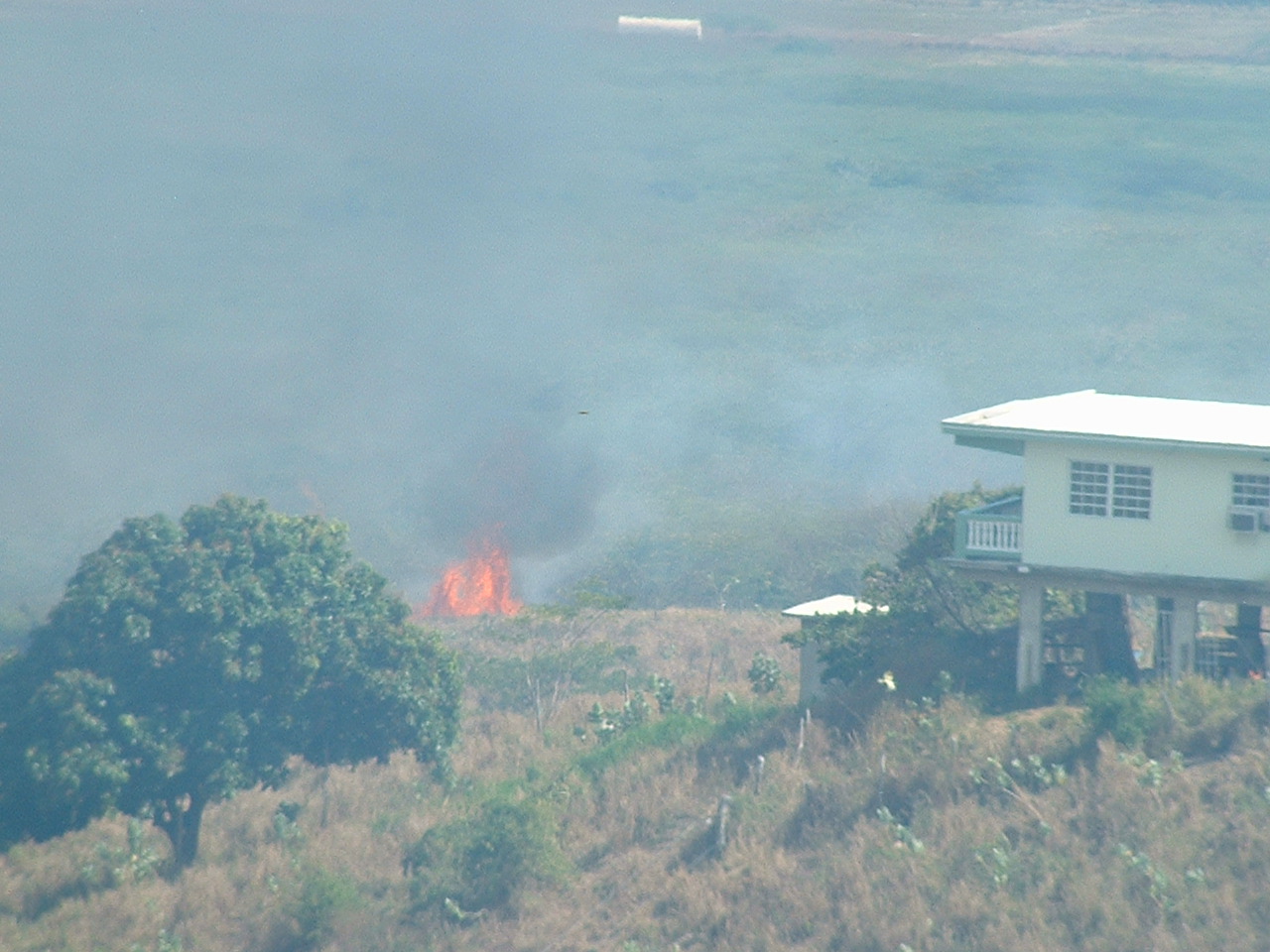
Fire weather ... overall dry and stable conditions will continue
across the local region with little precipitation in sight. as a
result ... grass and small bushes continue to dry up ... especially
across the southern half of the puerto rico. these conditions make
these sections very susceptible to fire. therefore ... all citizens
and visitors should take the necessary precautions and correctly
dispose of any flammable material or glass containers which can aid
in starting fires and damage our natural resources.
The above is from the NWS Office in San Juan.
It ias not rained at all in march at the San Juan Airport where the NWS Station is.Although it is normal to have dry days in March as it is the dryest month of the year since Febuary the deficit of rain has been evident.January was the most wettest month so far in 2005 as more than 4 inches of rain fell.There haved been many fires provoked by combustion caused by the dry and very warm temps especially in southern Puerto Rico.The 2005 total so far is 6.19 inches.In terms of looking to the future about the 2005 hurricane season there is no coalation between dry spells in the first 3 months of the year and more active Cape Verde seasons or not.I haved seen that in other areas of the caribbean such as Cuba water restrictions haved been implemented because of a dry spell there.
WEATHER ITEM OBSERVED TIME RECORD YEAR NORMAL DEPARTURE LAST
VALUE (LST) VALUE VALUE FROM YEAR
NORMAL
..................................................................
PRECIPITATION (IN)
TODAY 0.00 0.69 1960 0.06 -0.06 0.36
MONTH TO DATE T 0.90 -0.90 0.52
SINCE MAR 1 T 0.90 -0.90 0.52
SINCE JAN 1 6.19 6.22 -0.03 5.09
Drought,Fire Alert in Puerto Rico,any rest of carib reports?
Moderator: S2k Moderators
Forum rules

The posts in this forum are NOT official forecasts and should not be used as such. They are just the opinion of the poster and may or may not be backed by sound meteorological data. They are NOT endorsed by any professional institution or STORM2K. For official information, please refer to products from the National Hurricane Center and National Weather Service.
-
cycloneye

- Admin

- Posts: 148880
- Age: 69
- Joined: Thu Oct 10, 2002 10:54 am
- Location: San Juan, Puerto Rico
Drought,Fire Alert in Puerto Rico,any rest of carib reports?
Last edited by cycloneye on Thu Mar 17, 2005 5:52 pm, edited 1 time in total.
0 likes
-
cycloneye
- Admin
- Posts: 148880
- Age: 69
- Joined: Thu Oct 10, 2002 10:54 am
- Location: San Juan, Puerto Rico
FGCA72 TJSJ 151420
ESFSJU
PRC001-003-005-007-009-011-013-015-017-019-021-023-025-027-029-031-
033-035-037-039-041-043-045-047-049-051-053>055-057-059-061-063-065-
067-069-071-073-075-077-079-081-083-085-087-089-091-093-095-097-099-
101-103-105-107-109-111-113-115-117-119-121-123-125-127-129-131-133-
135-137-139-141-143-145-147-149-151-153-VIC010-020-030-172245-
HYDROLOGIC OUTLOOK
NATIONAL WEATHER SERVICE SAN JUAN PR
2:30 PM AST TUE MAR 15 2005
...PARTS OF SOUTHERN PUERTO RICO NOW IN MODERATE DROUGHT STATUS...
THE LACK OF RAINFALL IN PARTS OF SOUTHERN PUERTO RICO HAS BECOME
ACUTE IN MANY AREAS WITH THE RESULT THAT PARTS OF SOUTHEAST AND
SOUTH CENTRAL PUERTO RICO WILL BE ELEVATED TO MODERATE DROUGHT
STATUS BY THE U.S. DROUGHT MONITOR. MUCH OF THE REMAINDER OF THE
SOUTH AND WEST REMAINS IN THE THE ABNORMALLY DRY OR D0 CATEGORY.
WHILE MUCH OF PUERTO RICO HAS BEEN DRY FOR THE PAST SIX WEEKS THE
LACK OF RAINFALL IN THE SOUTH HAS PERSISTED FOR SEVERAL MONTHS IN
SOME AREAS. THE NORMALLY WET MONTH OF NOVEMBER WAS VERY DRY ALONG
THE SOUTH COAST AND SOUTHERN SLOPES OF PUERTO RICO HELPING TO SET UP
THIS AREA FOR THE DROUGHT CONDITIONS NOW OCCURRING. BOTH THESE
CLIMATE DISTRICTS HAD LESS THAN 40 PERCENT OF NORMAL RAINFALL IN
NOVEMBER. RAINFALL HAS BEEN BELOW NORMAL SINCE THAT TIME ACROSS THE
SOUTH AND WEST AND THESE AREAS ALMOST COMPLETELY MISSED THE HEAVY
RAINS THAT FELL ACROSS THE NORTH DURING THE FIRST SEVERAL WEEKS OF
JANUARY.
NUMEROUS BRUSH FIRES HAVE BEEN BREAKING OUT ACROSS THE SOUTH IN
RECENT WEEKS...A 400 PERCENT INCREASE OVER LAST YEAR IN ONE DISTRICT
NEAR PONCE. THERE HAVE BEEN REPORTS OF LACK OF GRASS FOR CATTLE IN
SOME AREAS AS WELL.
ANOTHER INDICATOR OF THE WORSENING SITUATION IS STREAMFLOW. THE
UNITED STATES GEOLOGICAL SURVEY (USGS) STREAM GAGING NETWORK SHOWS
SEVERAL STREAM GAGES IN THE SOUTHEAST PART OF PUERTO RICO AT RECORD
LOW FLOWS FOR THE DATE FOR SEVERAL WEEKS RUNNING...INCLUDING THE RIO
MAUNABO AT LIZAS...RIO VALENCIANO NEAR JUNCOS AND THE RIO GRANDE DE
PATILLAS NEAR PATILLAS. IN THE WEST...THE RIO GRANDE DE ANASCO NEAR
SAN SEBASTIAN REACHED RECORD LOW FLOWS FOR THE DATE IN RECENT DAYS.
CONVERSELY...FLOWS ON SEVERAL LARGE RIVERS IN THE NORTH CENTRAL PART
OF THE ISLAND CONTINUE TO HAVE ABOVE NORMAL FLOWS AT THIS TIME.
ACCORDING TO THE PUERTO RICO AQUEDUCT AND SEWER AUTHORITY (AAA)
RESERVOIR LEVELS ARE STILL ADEQUATE FOR WATER SUPPLY BUT WILL NEED
TO BE MONITORED CLOSELY IN COMING WEEKS. SEVERAL RESERVOIRS IN THE
SOUTH HAVE SEEN DECLINES IN POOL ELEVATIONS IN RECENT WEEKS...MOST
NOTABLY LAGO PATILLAS WHICH STEADILY DECLINED FROM ITS NORMAL POOL
ELEVATION OF 222 FEET TO 216.8 FEET TODAY. LAGO CARITE IN THE
HEADWATERS OF THE RIO DEL LA PLATA BASIN HAS FALLEN ABOUT TWO FEET
IN THE PAST MONTH...BUT REMAINS WELL ABOVE MINIMUM ELEVATIONS. LAGO
TOA VACA HAS FALLEN ABOUT 4 FEET IN THE PAST MONTH BUT IS STILL AT
AN ADEQUATE LEVEL.
IN THE SAN JUAN AREA IT HAS ALSO BEEN DRY BUT THE DROUGHT IS NOT YET
CONSIDERED TO AFFECT THE IMMEDIATE METRO AREA OR MOST OF NORTHERN
PUERTO RICO. STILL IT HAS BEEN MUCH DRIER THAN IS TYPICAL. FOR SAN
JUAN IT WAS THE 6TH DRIEST FEBRUARY SINCE 1956 WHEN CONTINUOUS
RECORDS BEGAN. THE FIRST 14 DAYS OF MARCH HAVE SEEN ONLY A TRACE OF
RAIN AT THE LUIS MUNOZ MARIN INTERNATIONAL AIRPORT.
THE NEAR TERM PRECIPITATION OUTLOOK FOR THE NORTHEAST CARIBBEAN DOES
NOT SUGGEST A TRANSITION TO A WET PATTERN ANYTIME SOON. THE PERIOD
FROM MID-MARCH TO MID-APRIL IS STILL CLIMATOLOGICALLY DRY FOR THE
REGION...BUT WITH INCREASING CHANCES FOR AFTERNOON CONVECTION. HENCE
THE SHORT-TERM DRYNESS ACROSS THE ISLAND WILL LIKELY GROW SOMEWHAT
WORSE IN COMING WEEKS. THE U.S. DROUGHT MONITOR ISSUANCE OF MARCH 8
2005 HAD SOUTHEAST...SOUTHERN AND WESTERN PUERTO RICO IN THE D0 OR
ABNORMALLY DRY CATEGORY. THE MARCH 15 DROUGHT MONITOR ISSUANCE WILL
ELEVATE PARTS OF THE SOUTH AND SOUTHEAST TO D1 OR MODERATE DROUGHT
STATUS. THIS IS BASED PRIMARILY ON REPORTED RAINFALL
DEFICITS...REDUCED STREAMFLOWS...SLOWLY FALLING RESERVOIR
LEVELS...THE INCREASING NUMBER OF BRUSHFIRE REPORTS AND LACK OF
AVAILABLE GRASS FOR GRAZING.
THE ONSET OF THE NORMAL CLIMATOLOGICAL INCREASE IN RAINFALL
BEGINNING IN APRIL AND ESPECIALLY MAY ACROSS THE REGION WILL HAVE A
MUCH MORE SIGNIFICANT IMPACT ON WHETHER DROUGHT CONDITIONS INTENSIFY
OR SPREAD ACROSS A LARGER PORTION OF THESE ISLANDS.
This new Bulletin came out this morning and rationing of water increases for us but hopefully it does not get to that as April and May arrive when normally are wet months here.
0 likes
Visit the Caribbean-Central America Weather Thread where you can find at first post web cams,radars
and observations from Caribbean basin members Click Here
and observations from Caribbean basin members Click Here

-
cycloneye
- Admin
- Posts: 148880
- Age: 69
- Joined: Thu Oct 10, 2002 10:54 am
- Location: San Juan, Puerto Rico
So far this month zip,nada,nothing to report about rainfall.Fires continue to rage in many places in the island.And no relief is in sight as the fronts dont dip southward to the tropical latituds anymore at this time of the year.We depend now on troughs that may form by april and by may and june the tropical waves that start to travel westbound from Africa.
Those who live in the caribbean can report what is going on in your area as this dry spell not only is in Puerto Rico but in most of the caribbean.I know that in Cuba water restrictions are going on due to the dry conditions there.
Those who live in the caribbean can report what is going on in your area as this dry spell not only is in Puerto Rico but in most of the caribbean.I know that in Cuba water restrictions are going on due to the dry conditions there.
0 likes
Visit the Caribbean-Central America Weather Thread where you can find at first post web cams,radars
and observations from Caribbean basin members Click Here
and observations from Caribbean basin members Click Here
-
cycloneye
- Admin
- Posts: 148880
- Age: 69
- Joined: Thu Oct 10, 2002 10:54 am
- Location: San Juan, Puerto Rico
000
fxca62 tjsj 200848
afdsju
area forecast discussion
national weather service san juan pr
445 am ast sun mar 20 2005
. synopsis ... at upper levels ... high pressure over the windward
islands moves east ... but high pressure reforms north of colombia on
friday and travels eastward through the caribbean over the coming
weekend.
at mid levels high pressure is centered east of the area with a
ridge over the entire caribbean sea. the center gradually moves over
puerto rico on thursday and is centered between jamaica and
hispaniola over the coming weekend. mid level moisture remains close
to zero.
at lower levels ... moisture continues to be weak with relative
humidity values rarely venturing over 70 percent. high pressure at
850 mb lies along 20 north just east of 60 west and builds in this
general area through tuesday. high pressure at the surface and 850
mb continues northeast of puerto rico for much of the coming 10 days
and surface flow oscillates between east and east southeast.
&&
. discussion ... considerable moisture is being picked up by the models
over the windward islands between 14 and 17 north. although some of
this moisture is moving in the east southeast flow toward the area
it is drying as it reaches the local area. although relative
humidities at 850 mb during the first part of the week sometimes
range as high as 75 percent ... they are also shadowed by relative
humidities below 50 percent to the east of the forecast area ... in
the same general area as the surface and 850 mb high pressure area.
in addition to relative humidities that are just not high enough to
support the formation of even modest convection ... the atmosphere is
well capped between 6 and 10 thousand feet. thus rain chances
continue to be very low and only exist in certain select areas.
there continues to exist a slight chance of measurable rain in the
convergence areas of western puerto rico during the mid and late
afternoons through thursday. and coastal late night rains are
remotely possible monday through thursday mornings ... but these
possibilities represent chances less than 20 percent and often down
into the single digits. overall ... until the high pressure moves and
subsidence ends allowing the atmosphere to gain some instability
this dearth of rain will continue. even out through 10 days the dry
pattern changes little in the models or our outlook.
&&
. fire weather ... unfortunately there is no good news to report here.
strong sunshine and almost no rain anywhere are allowing soils to
dry still more and plants and trees are now showing some distress
even in the wetter areas. this competition for sparse moisture will
cause soils to dry even more ... lowering stream flows further during
the week. satellite imagery shows a persistent pair of fires in the
pico duarte area of the dominican republic that have been burning
for over 24 hours ... demonstrating the increasing fire danger present
in this area of the caribbean.
The situation with the drought at the Caribbean is getting worse as no light at the end of the tunnel is seen in terms of rainfall.If it not rains in 40 days it is possible that water restrictions will be implemented in parts of Puerto Rico.
0 likes
Visit the Caribbean-Central America Weather Thread where you can find at first post web cams,radars
and observations from Caribbean basin members Click Here
and observations from Caribbean basin members Click Here


The south-east of England where I live has been very dry this winter in comprarision to what it should be.If this Spring and summer is also dry then there is little doubt that there could be a drought here,although any such event is still a long time off yet and zonality will probably return before then I suspect,or at least hope so anyway as I don't want a hosepipe ban!
0 likes
-
P.K.

- Professional-Met

- Posts: 5149
- Joined: Thu Sep 23, 2004 5:57 pm
- Location: Watford, England
- Contact:
I've read on TORRO that we have only had 55% of the expected PPN since November.
My automatic rainguage (Which does under read a bit) is only reading 51mm for the whole year so far. I would have expected 169mm so far using my 1994-2003 averages. It has be dry in Reading as well.
I remember the last hose pipe ban, but not the exact year it occured. Possibly 1995? That was a very hot and dry summer.
1994-2003 Averages
Jan 72.8
Feb 65.8
Mar 45.6
Apr 65.3
May 52.0
Jun 49.6
Jul 37.4
Aug 54.8
Sept 61.5
Oct 86.2
Nov 71.4
Dec 76.2
Total/Year 738.6
Month Average 61.6
0 likes


I believe so P.K,it was a very hot and dry summer which had the worst drought since the late 70's I think.It's all due to that dis-placed Azores high sticking close by to us in one form or another.Wether or not we get any problems in summer will now largely depend on how zonal condtions are during April and May but at the moment stil llooks like being fairly dry in the south-east and with only the frontal systems tommorow/Tuesday giving anything off notice and with temps staying quite abit above average this week.So we've gone directly from winter to late Spring,very rare for such a rapid transition although how long it last depends on the mass off water to our west!
0 likes
-
cycloneye
- Admin
- Posts: 148880
- Age: 69
- Joined: Thu Oct 10, 2002 10:54 am
- Location: San Juan, Puerto Rico
climate ... we are coming close to having model run forecasts out to
the end of the month and these indicate very little rain is expected
anywhere on the island. if conditions do remain dry ... it will result
in not only the driest march since the beginning of records in
1956 ... but also the driest month since 1956. the old march record
stands at 0. 72 inches set in 1970. the driest month ever was april
1997 with 0. 08 inches. we have had only a trace so far.
Ummm March may go with a new record if rain doesn't fall during the rest of the month.I really hope that next April doesn't be like the 1997 one.
0 likes
Visit the Caribbean-Central America Weather Thread where you can find at first post web cams,radars
and observations from Caribbean basin members Click Here
and observations from Caribbean basin members Click Here
-
cycloneye
- Admin
- Posts: 148880
- Age: 69
- Joined: Thu Oct 10, 2002 10:54 am
- Location: San Juan, Puerto Rico
climate...
global models continue to forecast this dry regime throughout the
remainder of the month and into the first week of april ... and then
indicate chances increasing for minor rainfall ... but not sufficient
to overcome our current water defects. no significant rainfall is
anticipated during the next 2 weeks. as was the case during the
1994 - 95 drought ... it may very well be that our current drought is
broken by a significant tropical wave moving across the region ... and
that may not occur until late may or june. small areas of puerto
rico will likely see some significant afternoon rainfall by that
time ... but widespread heavy rain may not effect us until wet
tropical waves become active across the region.
The Above from the NWS office in San Juan.Well I hope that tropical waves or troughs move thru soon because the drought conditions are worsening not only in Puerto Rico but in the rest of the caribbean Basin.
0 likes
Visit the Caribbean-Central America Weather Thread where you can find at first post web cams,radars
and observations from Caribbean basin members Click Here
and observations from Caribbean basin members Click Here

Drought also in Guadeloupe
After 6 months of intense rain,the drought is also arrived here !!!Since the begining of March,ther is no rain at all;here in my location,wee received only 5 mm, since the 1st of March,and this is the same in the rest of the island.
The fronts are no more in way to reach our islands,and sure if there are no thalwegs,or some upper cold air advection,the only way now to got some rain are the T/Wave's!!!!!
After all,this is the drought season,and March is climatologically the driest month of the year.
So,wee are waiting the upcoming hurricane season.So long to you cycloneye,and to all the friends of the board(there are no more earthquakes feeling since 1 month now in Guadeloupe!Fantastic.....)
0 likes

 and
and 
-
cycloneye
- Admin
- Posts: 148880
- Age: 69
- Joined: Thu Oct 10, 2002 10:54 am
- Location: San Juan, Puerto Rico
As I see the drought conditions is very extensive in many parts of the Caribbean Basin.As long as that upper ridge is stationary in the caribbean subsidence will cap convection from forming and that is not what we want to see.What we want to have is first that strong upper ridge move or weaken allowing for troughs to form helping then the moist air to pick up.Also we want to see the first tropical waves (Weak ones) move thru the caribbean from the month of May foward.Let's see if the dry spell breaks up soon.
0 likes
Visit the Caribbean-Central America Weather Thread where you can find at first post web cams,radars
and observations from Caribbean basin members Click Here
and observations from Caribbean basin members Click Here
-
cycloneye
- Admin
- Posts: 148880
- Age: 69
- Joined: Thu Oct 10, 2002 10:54 am
- Location: San Juan, Puerto Rico
. discussion...
all in all another dry forecast for the next week. once again the
stable mid to upper levels and lack of low level moisture supply
will keep the region relatively dry. the only change in this
scenario as suggested by the latest gfs guidance is beginning
wednesday into thursday. as the large and deep low now over the
southeast u. s. starts to exit the mid atlantic states on
tuesday ... the guidance indicates that it may help to lower the mid
to upper level geopotential heights over the region of the northeast
caribbean by wednesday into thursday. at that same time the guidance
develops a modest amount of low level moisture over the region and
indicates the potential for weak synoptic scale precip over the
region. the nam guidance ... however ... does not have the mid to upper
levels weakening quite as much and does not suggest any appreciable
source of low level moisture. therefore ... until it becomes more
apparent that there is a weakening of the mid to upper ridge and
some level moisture convergence ... will just keep some limited
potential for rainfall wednesday into thursday ... but more due to
local island effects in the afternoon hours.
Well at least some break of the dry spell in the next few days however it will not be sufficient to terminate the moderate drought that Southern Puerto Rico is experiencing since November.
0 likes
Visit the Caribbean-Central America Weather Thread where you can find at first post web cams,radars
and observations from Caribbean basin members Click Here
and observations from Caribbean basin members Click Here
-
cycloneye
- Admin
- Posts: 148880
- Age: 69
- Joined: Thu Oct 10, 2002 10:54 am
- Location: San Juan, Puerto Rico
area forecast discussion
national weather service san juan pr
430 pm ast wed mar 30 2005
. discussion...
modest amounts of moisture advecting into the area today combined
with a mild southeast wind flow and ample morning sunshine for
optimum diurnal forcing and the most widespread convective rain
coverage we have seen across puerto rico in a few months. a jet
streak associated with an upper trough providing 60 - 65 knot upper
winds moved across the area just before noon time to diminish the
stable subsident mid level dominance of the past two months ... and
did contribute to the convective development ... but was likely a few
hours early to produce thunderstorms. nws doppler radar showed one
scan with a 35k ft top across jayuya ... with tops then collapsing to
around 20k island wide. this convection will hang on through the
evening as it moves wnw and into the mona ... with skies then clearing
across most of the area.
a llvl perturbation moving across the lesser antilles today was
approaching st croix from the se this afternoon ... and will be
negatively affected by subsidence behind the upper trough later
tonight. still ... sufficient llvl moisture should advect into the st
croix area late this evening and overnight for scattered
showers ... and then modestly into p. r. on thursday for scattered
diurnal convection across the w and w interior again.
a transition has occurred during the past week from the extremely
stable regime with very weak showers ... to more moderate shower
activity. although rainfall remains limited ... and the middle
atmosphere still generally dry and stable ... sufficient llvl forcing
continues to produce moderate showers over both land and water.
light showers should therefore not be expected in our forecasts as
we slowly enter our wet season during the next 3 - 6 weeks. the rain
will come ... eventually ... albeit is likely to remain generally below
normal in terms of areal coverage.
At least some good news about some more moist air however the usual rains by late April and May should terminate the drought conditions here however let's see if the pattern is normal or the drought extends more in time.
0 likes
Visit the Caribbean-Central America Weather Thread where you can find at first post web cams,radars
and observations from Caribbean basin members Click Here
and observations from Caribbean basin members Click Here


Who is online
Users browsing this forum: kevin and 69 guests