what happened to the trade winds?

This is the general tropical discussion area. Anyone can take their shot at predicting a storms path.

Moderator: S2k Moderators

Forum rules

The posts in this forum are NOT official forecasts and should not be used as such. They are just the opinion of the poster and may or may not be backed by sound meteorological data. They are NOT endorsed by any professional institution or STORM2K. For official information, please refer to products from the National Hurricane Center and National Weather Service.

Help Support Storm2K
Message
Author
User avatar
msbee
S2K Supporter
S2K Supporter
Posts: 3044
Joined: Wed Jun 11, 2003 10:11 am
Location: St. Maarten

what happened to the trade winds?

#1 Postby msbee » Sun Mar 06, 2005 8:16 am

there is no wind.. none..zip..nada..
what happened?
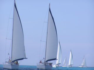
it is hot, hazy and humid with no wind and this weekend on St. Maarten the 25th annual Heineken Regatta is taking place.
Over 275 boats are taking part in 3 days of racing.
Racing? yea right! Most of them are sitting dead in the water.
It has been very difficult racing with no wind. On Friday it was the round the island race, 44 KM, I think. What usually would take maybe 3 hours took 7 +.
I think the most wind they got was on Saturday with an average of approximately 8 -10 knots.
they sure do look beautiful in the water though even though they are basically sitting still.
:roll:

Image
0 likes   

User avatar
msbee
S2K Supporter
S2K Supporter
Posts: 3044
Joined: Wed Jun 11, 2003 10:11 am
Location: St. Maarten

#2 Postby msbee » Sun Mar 06, 2005 9:19 am

not sure if you can see the pciture I posted
here it is smaller
enjoy!

Image
0 likes   

User avatar
cycloneye
Admin
Admin
Posts: 148504
Age: 69
Joined: Thu Oct 10, 2002 10:54 am
Location: San Juan, Puerto Rico

#3 Postby cycloneye » Sun Mar 06, 2005 5:06 pm

--------------------------------------------------------------------------------
Area Forecast Discussion
Latest Versions [Current][-1][-2][-3][-4][-5][-6][-7]

000
fxca62 tjsj 062039
afdsju

area forecast discussion
national weather service san juan pr
230 pm ast sun mar 6 2005

. synopsis ... at upper levels ... winds are generally zonal 35 to 55
knots at 250 mb with high pressure remaining entrenched over south
america and atlantic waters off their shores. on monday 14 march
ridging toward the north begins at 77 west in response to a trough
digging from the north along 50 west and flow over the area becomes
more northwest.

at mid levels ... high pressure extends across the caribbean and much
of the atlantic at the same latitude. by mid week a weak ridge
extends from central america across the caribbean and follows the
coast of south america in the atlantic. in the atlantic this high
shifts north over the coming weekend and a ridge extends north along
42 west. as a short wave moves through the northern atlantic ridging
occurs over cuba ... the bahamas and florida with northwest flow over
the local area by midweek next week. relative humidities in this
layer remain below 30 percent and sometimes below 10 percent the
entire period.

at lower levels ... a weak and diffuse trough is moving slowly south
southeast with some low and a little mid level moisture. models
bring the best relative humidity and theta - e values across at 03z
this evening. moisture slowly diminishes as the frontal system moves
about 80 miles south and dissipates and low level flow at 850 mb
eases to near zero. at the surface after the trough moves across the
area high pressure moves from the northern bahamas this morning to
about 27 north 60 west tuesday morning causing flow to turn
northeast at the surface in spite of weak low level pressure
gradients above the surface. high pressure to the east then remains
in control for the latter part of the week until another large high
pressure moves east off florida and north of puerto rico the
following tuesday.

&&

. discussion ... radar shows weak bandlets of showers peeling off of
the main frontal band and moving toward puerto rico ... but so far
they have all dissipated before coming within 20 miles of shore in
the northwest and 50 miles of shore in the northeast. satellite
pictures show the band containing mostly mid and some upper level
cloudiness moving toward the area very slowly and latest model
updates continue to bring the best moisture across the area about
03z with some residual moisture holding on through monday. based on
this ... have updated the morning forecast package and removed pops
from the north coastal zones for the rest of the afternoon. with
winds now firmly out of the north and moisture/cloudiness fairly
weak have also lowered pops to the south of the island tonight.
otherwise forecast package remains mostly unchanged with regards to
pops.

have reloaded dewpoint grids as model may have been too dry now and
later during the week.

once moisture winds down tomorrow afternoon ... the middle of the week
looks relatively dry ... though there may be scattered afternoon
showers due to robust convergence. models also show light winds
aloft and modest surface gradients which could help some interior
convection grow during the afternoons. but toward the end of the
week moisture may just be too limited to foster even this. some more
moisture will return by next weekend.

&&


. marine ... seas will slowly subside until early evening tomorrow.
then 10 to 11 second swell from just slightly west of north will
roll in early morning on tuesday ... but peak at 6 to 7 feet before
noon. seas will then subside to about 3 feet until thursday. several
more trains like this will push through early saturday and late
sunday.


A weak cold front will move thru increasing the winds tonight and on monday.The rest of the week will have NE to east winds but not too strong.
0 likes   
Visit the Caribbean-Central America Weather Thread where you can find at first post web cams,radars
and observations from Caribbean basin members Click Here

User avatar
depotoo
Category 5
Category 5
Posts: 3611
Joined: Mon Aug 11, 2003 9:29 pm
Location: west palm beach

#4 Postby depotoo » Sun Mar 06, 2005 6:12 pm

beautiful pictures msbee - thanks for sharing - oh what paradise!
0 likes   


Return to “Talkin' Tropics”

Who is online

Users browsing this forum: bird, DESTRUCTION5, kevin, MetroMike, pepecool20, TampaWxLurker and 628 guests