WONT41 KNHC 271818
DSAAT
SPECIAL TROPICAL DISTURBANCE STATEMENT
NWS TPC/NATIONAL HURRICANE CENTER MIAMI FL
215 PM EDT FRI AUG 27 2004
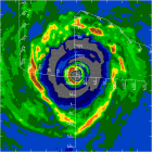
SATELLITE...RADAR...AND SURFACE OBSERVATIONS INDICATE THE
WELL-DEFINED LOW PRESSURE SYSTEM LOCATED ABOUT 140 MILES
SOUTHEAST OF CHARLESTON SOUTH CAROLINA HAS BECOME MUCH BETTER
ORGANIZED THIS AFTERNOON. THEREFORE...ADVISORIES WILL BE
INITIATED ON TROPICAL DEPRESSION SEVEN AT 5 PM EDT...2100Z.
A TROPICAL STORM WATCH WILL BE ISSUED FOR PORTIONS OF THE
GEORGIA AND SOUTH CAROLINA COASTS...AND POSSIBLY FOR A SMALL
PORTION OF THE NORTH CAROLINA COAST SINCE THE DEPRESSION IS
EXPECTED TO MOVE SLOWLY WESTWARD BY SATURDAY.
FORECASTER STEWART
TD#7 at 5PM!
Moderator: S2k Moderators
Forum rules

The posts in this forum are NOT official forecasts and should not be used as such. They are just the opinion of the poster and may or may not be backed by sound meteorological data. They are NOT endorsed by any professional institution or STORM2K. For official information, please refer to products from the National Hurricane Center and National Weather Service.
-
GaryOBX
- Tropical Depression

- Posts: 90
- Joined: Wed Sep 03, 2003 2:33 pm
- Location: Outer Banks, NC
- Contact:
TD#7 at 5PM!
0 likes
-
Stormcenter
- S2K Supporter

- Posts: 6687
- Joined: Wed Sep 03, 2003 11:27 am
- Location: Houston, TX
Re: TD#7 at 5PM!
GaryOBX wrote:WONT41 KNHC 271818
DSAAT
SPECIAL TROPICAL DISTURBANCE STATEMENT
NWS TPC/NATIONAL HURRICANE CENTER MIAMI FL
215 PM EDT FRI AUG 27 2004
SATELLITE...RADAR...AND SURFACE OBSERVATIONS INDICATE THE
WELL-DEFINED LOW PRESSURE SYSTEM LOCATED ABOUT 140 MILES
SOUTHEAST OF CHARLESTON SOUTH CAROLINA HAS BECOME MUCH BETTER
ORGANIZED THIS AFTERNOON. THEREFORE...ADVISORIES WILL BE
INITIATED ON TROPICAL DEPRESSION SEVEN AT 5 PM EDT...2100Z.
A TROPICAL STORM WATCH WILL BE ISSUED FOR PORTIONS OF THE
GEORGIA AND SOUTH CAROLINA COASTS...AND POSSIBLY FOR A SMALL
PORTION OF THE NORTH CAROLINA COAST SINCE THE DEPRESSION IS
EXPECTED TO MOVE SLOWLY WESTWARD BY SATURDAY.
FORECASTER STEWART
Wow that was quick!!! Thanks!!!!!
0 likes
-
Josephine96

-
Air Force Met
- Military Met

- Posts: 4372
- Age: 56
- Joined: Tue Jul 08, 2003 9:30 am
- Location: Roan Mountain, TN
-
Stormcenter
- S2K Supporter
- Posts: 6687
- Joined: Wed Sep 03, 2003 11:27 am
- Location: Houston, TX
Yes!!!!
Josephine96 wrote:Now the question is whether it'll become Gaston before landfall
YES!!!!!
0 likes
-
Josephine96

Plenty of time...
Josephine96 wrote:Slowly.. I guess we can now make that 7 named storms {assuming it earns it's name}
I think chances are very high TD#7 will reach T.S. status over the next 24 hours. 1) There is little to no shear, 2) the outflow is very condusive for development, 3) the center fix and forecast at 5pm will probably call for slow movement until the ridge pushes the system inland (i.e. it will have enough time and open water to intensify).
0 likes

-
charleston_hugo_veteran

- S2K Supporter
- Posts: 1590
- Joined: Thu Sep 04, 2003 12:47 pm
- Location: Charleston, S.C.
-
Hurricanehink

- S2K Supporter
- Posts: 2047
- Joined: Sun Nov 16, 2003 2:05 pm
- Location: New Jersey
Who is online
Users browsing this forum: No registered users and 131 guests