
The following linked map shows the current MJO situation:
http://www.cpc.ncep.noaa.gov/products/g ... thly_1.gif
Any comments regarding this map's implications for the Atlantic tropics for the next few days?
Current MJO
Moderator: S2k Moderators
Forum rules

The posts in this forum are NOT official forecasts and should not be used as such. They are just the opinion of the poster and may or may not be backed by sound meteorological data. They are NOT endorsed by any professional institution or STORM2K. For official information, please refer to products from the National Hurricane Center and National Weather Service.
Current MJO
0 likes
Personal Forecast Disclaimer:
The posts in this forum are NOT official forecasts and should not be used as such. They are just the opinion of the poster and may or may not be backed by sound meteorological data. They are NOT endorsed by any professional institution or storm2k.org. For official information, please refer to the NHC and NWS products.
The posts in this forum are NOT official forecasts and should not be used as such. They are just the opinion of the poster and may or may not be backed by sound meteorological data. They are NOT endorsed by any professional institution or storm2k.org. For official information, please refer to the NHC and NWS products.
-
cycloneye

- Admin

- Posts: 148791
- Age: 69
- Joined: Thu Oct 10, 2002 10:54 am
- Location: San Juan, Puerto Rico
Right now the grafic shows that the MJO factor is in a dry phase meaning not favorable for tropical development however it doesn't mean that something may form but it will be harder for a system to form under a dry MJO.By mid august the wet phase will invade the atlantic and that is when we will see really a jump on developments
Last edited by cycloneye on Sun Jul 25, 2004 1:48 pm, edited 1 time in total.
0 likes
Visit the Caribbean-Central America Weather Thread where you can find at first post web cams,radars
and observations from Caribbean basin members Click Here
and observations from Caribbean basin members Click Here
-
Stormsfury

- Category 5

- Posts: 10549
- Age: 53
- Joined: Wed Feb 05, 2003 6:27 pm
- Location: Summerville, SC


Stormsfury wrote:The next phase of the wet MJO cycle is due in right at the time when climatologically speaking, is the most favored for development across the tropical Atlantic.
That alone could be huge (talk about the "lid coming off"). However let's see what the next wet phase does for EPAC activity as the wave propagates eastward.
0 likes
Thanks everyone for your replies. I'm trying to learn more about the MJO cycle and how strong an indicator both the wet phase is for development and the dry phase is for the lack of development.
0 likes
Personal Forecast Disclaimer:
The posts in this forum are NOT official forecasts and should not be used as such. They are just the opinion of the poster and may or may not be backed by sound meteorological data. They are NOT endorsed by any professional institution or storm2k.org. For official information, please refer to the NHC and NWS products.
The posts in this forum are NOT official forecasts and should not be used as such. They are just the opinion of the poster and may or may not be backed by sound meteorological data. They are NOT endorsed by any professional institution or storm2k.org. For official information, please refer to the NHC and NWS products.
-
Stormsfury
- Category 5
- Posts: 10549
- Age: 53
- Joined: Wed Feb 05, 2003 6:27 pm
- Location: Summerville, SC
-
The Dark Knight

- Category 3

- Posts: 800
- Joined: Fri Jun 18, 2004 11:18 am
- Location: Mashpee, Cape Cod, MA
- Contact:
-
rainstorm
-
Anonymous
USAwx1 wrote:Stormsfury wrote:The next phase of the wet MJO cycle is due in right at the time when climatologically speaking, is the most favored for development across the tropical Atlantic.
That alone could be huge (talk about the "lid coming off"). However let's see what the next wet phase does for EPAC activity as the wave propagates eastward.
Yep, I agree with this statement SF. It will take awhile but in about three weeks, the Atlantic basin should become more active, possibly at a rapid rate. People can't forget that "inactive" early seasons can easily make a 180 degree turn during the main season, or "balance out" so to speak. So by late August/early September, we could, theoretically speaking, be tracking two or three active storms at once.
0 likes
-
wxman57

- Moderator-Pro Met

- Posts: 23151
- Age: 68
- Joined: Sat Jun 21, 2003 8:06 pm
- Location: Houston, TX (southwest)
Here's a better MJO link:
http://www.cpc.ncep.noaa.gov/products/p ... index.html
And here's a good link with MJO info:
http://www-das.uwyo.edu/~geerts/cwx/not ... 2/mjo.html
Here's a good link with past year's MJO cycles:
http://www.cpc.ncep.noaa.gov/products/p ... entad.html
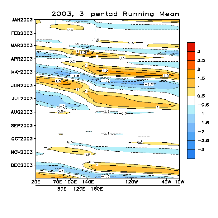
Below is 2003's MJO graphic. Note the big push east of negative OLR values into the Atlantic basin in June/July. That one led to Bill and Claudette.
http://www.cpc.ncep.noaa.gov/products/p ... r_2003.gif
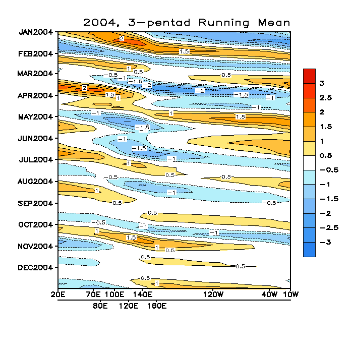
And for 2004. Note only 1 good, strong MJO back in April:
http://www.cpc.ncep.noaa.gov/products/p ... r_2004.gif
http://www.cpc.ncep.noaa.gov/products/p ... index.html
And here's a good link with MJO info:
http://www-das.uwyo.edu/~geerts/cwx/not ... 2/mjo.html
Here's a good link with past year's MJO cycles:
http://www.cpc.ncep.noaa.gov/products/p ... entad.html
Below is 2003's MJO graphic. Note the big push east of negative OLR values into the Atlantic basin in June/July. That one led to Bill and Claudette.
http://www.cpc.ncep.noaa.gov/products/p ... r_2003.gif
And for 2004. Note only 1 good, strong MJO back in April:
http://www.cpc.ncep.noaa.gov/products/p ... r_2004.gif
0 likes
Who is online
Users browsing this forum: Google Adsense [Bot], Steve and 126 guests