Interesting..Back north of the mean position..I wonder if it will stay there for the Cape season..
http://www.cpc.ncep.noaa.gov/products/f ... /itcz.html
Latest Text Summary
--------------------------------------------------------------------------------
From June 21-30 2004, the overall longitude-averaged position of the Africa ITCZ surged northward, especially in the east, and was located near 16.3 north latitude. The latest position is around 1.4 degrees north from its location during the second dekad of June, though the 2003 position during the current dekad was closer to 16.9N. This strong northward movement is not normally seen during the north-to-south progression of the ITCZ, though it resembles its retreat in September or October. Examining Figures 2 and 3, it is seen that the contribution of this northward jump was mainly from the east as opposed to western longitudes. This can also be seen in Figure 1 in the area from Niger eastward. For the record, the western (10W-10E) area of the ITCZ was located near 17.0N as opposed to the climatological mean of 16.8N. The eastern (20-35N) area's current and mean positions were 15.9 and 14.2 north, respectively. Associated with the latest movement, increased rains were seen in southern Senegal, central Mali, and southern Chad during the last period, while dryness was seen along parts of the Ivory Coast.
ITCZ Peaked Early..
Moderator: S2k Moderators
Forum rules

The posts in this forum are NOT official forecasts and should not be used as such. They are just the opinion of the poster and may or may not be backed by sound meteorological data. They are NOT endorsed by any professional institution or STORM2K. For official information, please refer to products from the National Hurricane Center and National Weather Service.
-
Aquawind

- Category 5

- Posts: 6714
- Age: 62
- Joined: Mon Jun 16, 2003 10:41 pm
- Location: Salisbury, NC
- Contact:
ITCZ Peaked Early..
Last edited by Aquawind on Sat Sep 18, 2004 6:51 am, edited 3 times in total.
0 likes
-
hurricanetrack

- HurricaneTrack.com
- Posts: 1781
- Joined: Tue Dec 02, 2003 10:46 pm
- Location: Wilmington, NC
- Contact:
I wonder what this means?
This is from the text:
"though it resembles its retreat in September or October"
What does that mean?
"though it resembles its retreat in September or October"
What does that mean?
0 likes
-
CaluWxBill

- Category 2

- Posts: 577
- Joined: Sun Dec 21, 2003 8:31 pm
- Location: Southwest PA
- Contact:
I am not sure what exactly the retreat means, although the jet stream does tend to shift northward during the cape verde season of the tropics when storms really start firing. but the far western portion of the ITCZ is still south of it mean. This basically means Waves are coming off of the African coast close to the equator. and I wouldn't expect any cyclonic activity to occur, but it is shifting north somewhat, and if the trend continues, we could see more sustainable activity.
0 likes
-
Aquawind
- Category 5
- Posts: 6714
- Age: 62
- Joined: Mon Jun 16, 2003 10:41 pm
- Location: Salisbury, NC
- Contact:
I would assume as stated the surge northward during this 10 day period is something more common with the retreat to the south. Looking at the graphics the movement is morth gradual towards the north and the retreat south is more abrupt.


The movement was most notable in the eastern portion and the western portion still is about normal.. In 1995 the Western portion of the ITCZ was well north of the mean position early and for a prolonged period..The last couple of active years the west ITCZ was north of the mean position..even though we only had minor CV activity..It will be interesting to see if a active CV season occurs this year.
In 1995 an abrupt bump north durring June also occured but on the Western portion.. from 15.9 to 17.7 in the last decal period. The ITCZ got to 18N durring early july and stayed above 18 through the first period of October! Wayyy north of mean for a longgg time..Hence busy season 1995 was..
Last edited by Aquawind on Thu Jul 22, 2004 8:22 am, edited 1 time in total.
0 likes
-
CaluWxBill
- Category 2
- Posts: 577
- Joined: Sun Dec 21, 2003 8:31 pm
- Location: Southwest PA
- Contact:
Aquawind wrote:I would assume as stated the surge northward during this 10 day period is something more common with the retreat to the south. Looking at the graphics the movement is morth gradual towards the north and the retreat south is more abrupt.
The movement was most notable in the eastern portion and the western portion still is about normal.. In 1995 the Western portion of the ITCZ was well north of the mean position early and for a prolonged period..The last couple of active years the west ITCZ was north of the mean position..even though we only had minor CV activity..It will be interesting to see if a active CV season occurs this year.
In 1995 an abrupt bump north durring June also occured but on the Western portion.. from 15.9 to 17.7 in the last decal period. The ITCZ got to 18N durring early july and stayed above 18 through the first period of October! Wayyy north of mean for a longgg time..Hence busy season 1995 was..
I misunderstood them greatly then. I was confused that they were comparing a retreat to a surge, your post clears it up greatly. Yeah it makes perfect sense.
0 likes
-
Aquawind
- Category 5
- Posts: 6714
- Age: 62
- Joined: Mon Jun 16, 2003 10:41 pm
- Location: Salisbury, NC
- Contact:
Well it has made another dramatic jump northward.. 
Latest Text Summary
--------------------------------------------------------------------------------
During the first dekad of July 2004, the African portion of the ITCZ continued to move significantly northward from its position during the final dekad of June. For the period, the longitude- and dekadal-averaged location was near 17.8N, compared to last week's position near 16.3N, last year's position of 17.9N and the 1988-2003 climatological normal of 16.5N. Contributing to the strong northward bias in the west was a stronger than normal surface low pressure area near northern Mali and Western Mauritania which brought moderate southerly winds into the region and pushed the ITCZ northward. Northerly winds on the western side of the low were checked in that they influenced the ITCZ somewhat less than normal. Examining the western region from 10W-10E as shown in Figure 2, it is seen that the average position moved more than two degrees north from the previous dekad and is located near 19.4N. In the east from 20-35E, the ITCZ moved little from last period and is located near 15.9N.
0 likes
-
Aquawind
- Category 5
- Posts: 6714
- Age: 62
- Joined: Mon Jun 16, 2003 10:41 pm
- Location: Salisbury, NC
- Contact:
The ITCZ is in position well ahead of schedule and further north then the season max in the east already..1995..
http://www.cpc.noaa.gov/products/fews/ITCZ/itcz.html
http://www.cpc.noaa.gov/products/fews/ITCZ/itcz.html
0 likes
-
Aquawind
- Category 5
- Posts: 6714
- Age: 62
- Joined: Mon Jun 16, 2003 10:41 pm
- Location: Salisbury, NC
- Contact:
And yet Agian it is way North! ..Now coming off the coast..Way down in the East...
Same links above all are current..
http://www.cpc.noaa.gov/products/fews/ITCZ/itcz.html
During the period from July 21-31, 2004, the longitude-averaged African portion of the ITCZ was located near 18.5 degrees north latitude, compared to last period's position of 18.3 and the 1988-2003 mean of 18.3N. Again nearly stationary compared to the previous dekad, the ITCZ was influenced by a strong low pressure system located over the western Sahara Desert. This brought strong southerly winds and increased moisture to areas east of Mali and somewhat stronger than normal northerly winds westward to the Atlantic coast. Much of the period saw unusually strong northerly winds blowing dry air and warmer temperatures from The Mediterranean through eastern Libya and Egypt into Chad and Sudan. Figure 1 shows current dekadal precipitation with current and mean ITCZ data. Examining Figure 2, A it is noted that the western area of the ITCZ continued moving north during the period and was located near 20.7N compared to a normal position of 19.3N.lso unusual were conditions in the east as seen in Figure 3. From the eastern analysis, it is seen that the current ITCZ position was near 15.5N, compared to normal of 16.7N. The ITCZ actually moved 1.3 degrees south from the previous period!
0 likes

-
Aquawind
- Category 5
- Posts: 6714
- Age: 62
- Joined: Mon Jun 16, 2003 10:41 pm
- Location: Salisbury, NC
- Contact:
According to previous seasons it could very well be..There have been a few dud CV seasons wether or not the ITCZ was an issue I don't know..If the western portion of the ITCCZ stays above 18N till Oct it will be busy imho..Here is a link to a spreadsheet of the data available..
http://www.cpc.noaa.gov/products/fews/data.html
http://www.cpc.noaa.gov/products/fews/data.html
0 likes
-
Aquawind
- Category 5
- Posts: 6714
- Age: 62
- Joined: Mon Jun 16, 2003 10:41 pm
- Location: Salisbury, NC
- Contact:
Well Well Well...It's below average now in a dramatic drop in the west..Yet activity has picked up as we enter prime time..It will be interesting to see how things are in a month..Might be a quiet later CV season..sure as heck isn't now..
During the period from August 1-10, 2004, the longitude-averaged African portion of the ITCZ was located near 17.6 degrees north latitude, compared to last period's position of 18.5 degrees north latitude and the 1988-2003 mean position of 18.4 degrees north latitude. Northerly winds blew across Mauritainia and northern Mali, pushing the ITCZ southward in the western Sahel. These winds resulted in a dramatic southward shift of the ITCZ of 3 to 4 degrees latitude over Mauritainia and central Mali. Further east, southerly winds helped to lift the ITCZ northward to more seasonable latitudes across Chad and Sudan. The average position of the ITCZ over central Niger was more or less unchanged and remains close to its climatological position.
During the period from August 1-10, 2004, the longitude-averaged African portion of the ITCZ was located near 17.6 degrees north latitude, compared to last period's position of 18.5 degrees north latitude and the 1988-2003 mean position of 18.4 degrees north latitude. Northerly winds blew across Mauritainia and northern Mali, pushing the ITCZ southward in the western Sahel. These winds resulted in a dramatic southward shift of the ITCZ of 3 to 4 degrees latitude over Mauritainia and central Mali. Further east, southerly winds helped to lift the ITCZ northward to more seasonable latitudes across Chad and Sudan. The average position of the ITCZ over central Niger was more or less unchanged and remains close to its climatological position.
0 likes
-
Aquawind
- Category 5
- Posts: 6714
- Age: 62
- Joined: Mon Jun 16, 2003 10:41 pm
- Location: Salisbury, NC
- Contact:
Well as you can see the West is close to mean and the east has surprisingly pushed well north of mean as the ITCZ reached it yearly northern most point..Fact is the ITCZ moved north at both ends..It will be intersting to see if this trend continues..
Graphics above are current.
CPC verbage..
During the period from August 11-20, 2004, the longitude-averaged African portion of the ITCZ was located near 19.2 degrees north latitude, compared to last period's position of 17.6 degrees north latitude and the 1988-2003 mean position of 18.5 degrees north latitude. The ITCZ reaches its climatological northern-most position during the August 11-20 period. Weak low pressure areas over central Mauritainia and central Mali helped to lift the ITCZ northward over the western Sahel, while southerly winds helped to push the ITCZ northward over Sudan and Chad
As we head into Prime Time...
0 likes
-
Aquawind
- Category 5
- Posts: 6714
- Age: 62
- Joined: Mon Jun 16, 2003 10:41 pm
- Location: Salisbury, NC
- Contact:
Grapics above are current..
Dramatic drop in the East.. and a hint it's northward movement may have peaked on schedule..Hopefully this is the case and we will have a quiet end to the season..
Sorry I posted this so late as the new update will come out soon and we will know for sure if the ITCZ has begun to shift south as expected..there have been some dramatic shifts this year another is possible..
During the period from August 21-31 2004, the African portion of the ITCZ moved dramatically to the south in the eastern half of the continent. This movement is best illustrated in figure 3 which shows the current versus mean position averaged from 20-35 degrees east longitude. During the past dekad, the eastern region of the ITCZ moved from around 19N to around 15N. This contrasts the movement in the west, as shown in figure 2. In this region, the ITCZ moved relatively little from last period and is located very close to the 1988-2003 climatological mean. Figure 1 shows the overall position of the ITCZ compared to last period and the long term normal. The longitude-averaged location during the recent period was near 17.4N compared to the normal of near 18.2N and last period of near 19.2N. The ITCZ should be and appears to be retrograding to the south, as the normal northward peak occurs during the second dekad of August.
0 likes
-
Aquawind
- Category 5
- Posts: 6714
- Age: 62
- Joined: Mon Jun 16, 2003 10:41 pm
- Location: Salisbury, NC
- Contact:
Well it looks like the migration southward had started...hopefully a quiet end to the season..
Graphics above are current..
During the period from September 1-10 2004, the African region of the Intertropical Convergence Zone was located near 16.3 degrees north latitude when averaged from 15W-35E. The overall current position, along with the 1988-2003 normal is displayed in figure 1. From this graphic it is seen that virtually the entire ITCZ is currently south of the long term mean position and the western region moved significantly southward from the previous dekad. In fact, examining figures 2 and 3, it is seen that the movement in the 10W-10E region was around 1.6 degrees south during the period, while the east from 20-35E moved very little during the past ten days. For the 2004 season, it is apparent that the maximum northward location of the ITCZ in the west occurred around two dekads early during the last dekad of July, while the west saw a temporally normal but northward biased peak during the second dekad of August.
Another Dekad will be coming out this next week..
0 likes
-
Aquawind
- Category 5
- Posts: 6714
- Age: 62
- Joined: Mon Jun 16, 2003 10:41 pm
- Location: Salisbury, NC
- Contact:
Well it looks official the ITCZ has peaked early and is currently a little ahead of schedule for the migration south..
Graphics above are current..
From September 11-20, 2004, the African region of the Intertropical Convergence Zone was located near 15.2 degrees north latitude, compared with the 1988-2003 mean of 17.0N and a previous position of near 16.3N. Examining figure 1 which shows current, previous, and normal ITCZ position with accumulated dekadal precipitation, one can see that the current ITCZ location is very close to the maximum northward extent of current rainfall. One can also see that the entire longitude of ITCZ is currently southward of its normal position, though areas to the west appear slightly more displaced than in eastern areas. Examining the west averaged from 10W-10E, the ITCZ is currently located near 16.2N, compared to last period's 17.6N and the normal of 17.8N. The east (figure 3: 20-35E) is currently located near 14.1N, while the normal location is 15.6N and last period saw the average near 14.9N. From the two graphs, it is seen that the ITCZ is now progressing to the south at a near normal rate, though the actual location is south of normal, especially near Chad and Sudan.
0 likes
-
Aquawind
- Category 5
- Posts: 6714
- Age: 62
- Joined: Mon Jun 16, 2003 10:41 pm
- Location: Salisbury, NC
- Contact:
Ok Then..This will be my last update of the ITCZ this season as the Cape Verde season is pretty much over..Yes waves will still progress along the ITCZ and could eventually develop but probably not in the Eastern Atlantic..
One thing I noticed throughout the season is the western part of the ITCZ has has not come straight off the coast most of the seaon..For some reason it has had a pretty sharp angle towards the SW and still does. Notice the Mean comes off the coast with a WNW angle even now and that has not been the case all season..Something has pushed the ITCZ southward as it exits the coast..wether it's the Azores High or not I don't know..I thought the Azores was actually weaker this year...
Obviously the early north peak to the ITCZ didn't hinder the CV season as it has been much more active than the last couple years.
Either way were not going to have any extended ITCZ season like we experienced in 1995 when it was further north than the mean well into October..
http://weather.unisys.com/hurricane/atl ... index.html
Sure wish we had data going back to 1950 at least even though this is only one peace to the big puzzle..
CPC verbage below..
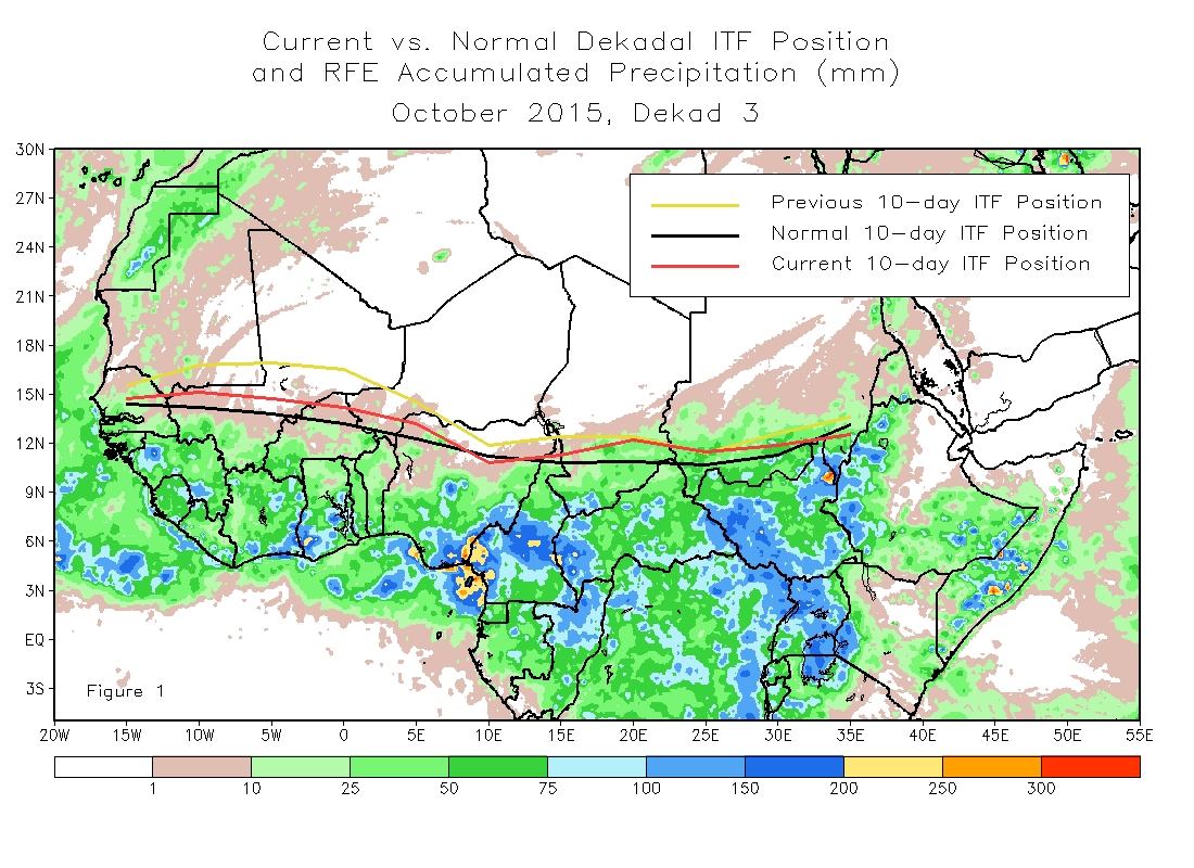
During the final dekad of September 2004, the African portion of the Intertropical Convergence Zone was located near 15.0 degrees north latitude, compared with the 1988-2003 long term mean of 16.0N and last dekad's position near 15.2N. Overall, the ITCZ moved very little from the second dekad of the month, though it did recess in southern Mauritania and eastern Senegal. Examining figure 1, rains were generally near normal during the period, though some extreme amounts were seen near the southern Nigeria / Cameroon border region. The western portion of the ITCZ, seen in figure 2, is located near 15.8N compared with the long term mean position of 16.7N. The eastern region is closer to normal and is currently located near 14.2N.
One thing I noticed throughout the season is the western part of the ITCZ has has not come straight off the coast most of the seaon..For some reason it has had a pretty sharp angle towards the SW and still does. Notice the Mean comes off the coast with a WNW angle even now and that has not been the case all season..Something has pushed the ITCZ southward as it exits the coast..wether it's the Azores High or not I don't know..I thought the Azores was actually weaker this year...
Obviously the early north peak to the ITCZ didn't hinder the CV season as it has been much more active than the last couple years.
Either way were not going to have any extended ITCZ season like we experienced in 1995 when it was further north than the mean well into October..
http://weather.unisys.com/hurricane/atl ... index.html
Sure wish we had data going back to 1950 at least even though this is only one peace to the big puzzle..
CPC verbage below..
During the final dekad of September 2004, the African portion of the Intertropical Convergence Zone was located near 15.0 degrees north latitude, compared with the 1988-2003 long term mean of 16.0N and last dekad's position near 15.2N. Overall, the ITCZ moved very little from the second dekad of the month, though it did recess in southern Mauritania and eastern Senegal. Examining figure 1, rains were generally near normal during the period, though some extreme amounts were seen near the southern Nigeria / Cameroon border region. The western portion of the ITCZ, seen in figure 2, is located near 15.8N compared with the long term mean position of 16.7N. The eastern region is closer to normal and is currently located near 14.2N.
0 likes
Who is online
Users browsing this forum: FireRat, HurricaneRyan, tolakram and 142 guests