Is there a tornado threat in D.C. tomorrow?
Moderator: S2k Moderators
Forum rules

The posts in this forum are NOT official forecast and should not be used as such. They are just the opinion of the poster and may or may not be backed by sound meteorological data. They are NOT endorsed by any professional institution or STORM2K.
-
yoda

- Category 5

- Posts: 7874
- Joined: Tue Jan 13, 2004 3:51 pm
- Location: Springfield VA (20 mins south of DC)
- Contact:
Is there a tornado threat in D.C. tomorrow?
Does anyone know? SPC and the LWX AFD seems to highlight this... any help would be appreciated! Thanks!
0 likes
-
Stormsfury

- Category 5
- Posts: 10549
- Age: 53
- Joined: Wed Feb 05, 2003 6:27 pm
- Location: Summerville, SC
-
yoda
- Category 5
- Posts: 7874
- Joined: Tue Jan 13, 2004 3:51 pm
- Location: Springfield VA (20 mins south of DC)
- Contact:
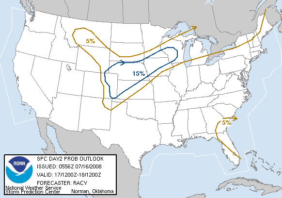
SPC 0800 OUTLOOK DAY 2
SHEAR WILL INCREASE DURING THE DAY ACROSS MID ATLANTIC STATES AHEAD
OF WIND MAX AND DEVELOPING LEE LOW. BY AFTERNOON SFC-6KM SHEAR OF
40-50 KT WILL SUPPORT ORGANIZED THUNDERSTORM DEVELOPMENT EITHER WITH
COLD FRONT OR OUTFLOW FROM EARLIER OVERNIGHT ACTIVITY. ENHANCED LOW
LEVEL SHEAR AND CONVERGENCE VICINITY OF WARM FRONT/SURFACE LOW
SUGGEST POTENTIAL FOR SUPERCELLS DELMARVA PORTION OF OUTLOOK. IN
ADDITION TO DAMAGING WIND THREAT THERE COULD BE A TORNADO THREAT AS
WELL GIVEN THE LOW LCL'S AND POTENTIAL INSTABILITY AND SHEAR
PROFILES. LATER OUTLOOKS WILL BE BETTER ABLE TO EVALUATE TORNADO
POTENTIAL GIVEN THE UNCERTAINTY YET IN THE MODEL EVOLUTION IN THIS
AREA.
0 likes
-
Stormsfury
- Category 5
- Posts: 10549
- Age: 53
- Joined: Wed Feb 05, 2003 6:27 pm
- Location: Summerville, SC
-
Stormsfury
- Category 5
- Posts: 10549
- Age: 53
- Joined: Wed Feb 05, 2003 6:27 pm
- Location: Summerville, SC
It's VERY rare that a moderate risk would go up in the Mid-Atlantic or even anywhere in the East 24 hours in advance under even more certain conditions, let alone the uncertain variables right now ... plus your threat isn't until tomorrow and not imminent. SPC will be highly concentrating on the outbreak getting ready to explode back in AR/MO/IL today ...
SF
SF
0 likes
-
Skywatch_NC

- Category 5
- Posts: 10949
- Joined: Wed Feb 05, 2003 9:31 pm
- Location: Raleigh, NC
- Contact:
Matt, it looks like your area is about right on a 25%-15% boundary for tomorrow!
http://www.spc.noaa.gov/products/outloo ... 00_any.gif
http://www.spc.noaa.gov/products/outloo ... 00_any.gif
0 likes
-
Skywatch_NC
- Category 5
- Posts: 10949
- Joined: Wed Feb 05, 2003 9:31 pm
- Location: Raleigh, NC
- Contact:
-
Skywatch_NC
- Category 5
- Posts: 10949
- Joined: Wed Feb 05, 2003 9:31 pm
- Location: Raleigh, NC
- Contact:
That's still a significant threat this far east. 15-25% probability is still significant enough for a slight risk and folks any storm that is severe is dangerous.
A severe storm is classified when the following occur
Thunderstorm wind gust 58 mph or greater
hail 3/4 inch in diameter or larger
tornadoes
All three possibilities exists tomorrow, but I'm leaning more towards damaging gusts!!
Jim
A severe storm is classified when the following occur
Thunderstorm wind gust 58 mph or greater
hail 3/4 inch in diameter or larger
tornadoes
All three possibilities exists tomorrow, but I'm leaning more towards damaging gusts!!
Jim
0 likes
-
Anonymous
-
wx247

- S2K Supporter

- Posts: 14279
- Age: 42
- Joined: Wed Feb 05, 2003 10:35 pm
- Location: Monett, Missouri
- Contact:
You mean you don't take Jebwalks in tornadoes?? 
0 likes
Personal Forecast Disclaimer:
The posts in this forum are NOT official forecast and should not be used as such. They are just the opinion of the poster and may or may not be backed by sound meteorological data. They are NOT endorsed by any professional institution or storm2k.org. For official information, please refer to the NHC and NWS products.
The posts in this forum are NOT official forecast and should not be used as such. They are just the opinion of the poster and may or may not be backed by sound meteorological data. They are NOT endorsed by any professional institution or storm2k.org. For official information, please refer to the NHC and NWS products.
-
Skywatch_NC
- Category 5
- Posts: 10949
- Joined: Wed Feb 05, 2003 9:31 pm
- Location: Raleigh, NC
- Contact:
-
Anonymous
Jeb wrote:yoda wrote:I live south of D.C., so I am in the 25% area.. I am guessing you are just outside the 25% area?
I am scared to death of tornadoes. I want lots of rain, like about 4 to 8 inches of rain, but I DO NOT want a tornado.
-Jeb (already quaking in his boots lol)
Don't BRING IT to Jeb weather gods.
0 likes
Return to “USA & Caribbean Weather”
Who is online
Users browsing this forum: Google [Bot] and 168 guests