http://www.ssd.noaa.gov/PS/TROP/DATA/RT ... -loop.html
That area came out of Mexico early this morning but nothing to open eyebrows about development.That is on the tail end of a front but it has to persist for more than 24-36 hours to then take a second look.
Bay of campeche
Moderator: S2k Moderators
Forum rules
The posts in this forum are NOT official forecasts and should not be used as such. They are just the opinion of the poster and may or may not be backed by sound meteorological data. They are NOT endorsed by any professional institution or STORM2K. For official information, please refer to products from the National Hurricane Center and National Weather Service.
- cycloneye
- Admin

- Posts: 148767
- Age: 69
- Joined: Thu Oct 10, 2002 10:54 am
- Location: San Juan, Puerto Rico
Bay of campeche
Last edited by cycloneye on Tue Apr 27, 2004 12:32 pm, edited 1 time in total.
0 likes
Visit the Caribbean-Central America Weather Thread where you can find at first post web cams,radars
and observations from Caribbean basin members Click Here
and observations from Caribbean basin members Click Here
- HurricaneGirl
- Category 5

- Posts: 5839
- Age: 61
- Joined: Thu Feb 06, 2003 9:45 am
- Location: Clare, Michigan
- Contact:
- cycloneye
- Admin

- Posts: 148767
- Age: 69
- Joined: Thu Oct 10, 2002 10:54 am
- Location: San Juan, Puerto Rico
http://www.ssd.noaa.gov/PS/TROP/DATA/RT ... -loop.html
Yes David weakening slowly the area as shear and not so warm sst's are doing their thing however there may be a very weak low embedded there NW of the Yucatan penninsula if you look closely at this visible loop but as you said by june things may change to more favorable in the GOM.
Yes David weakening slowly the area as shear and not so warm sst's are doing their thing however there may be a very weak low embedded there NW of the Yucatan penninsula if you look closely at this visible loop but as you said by june things may change to more favorable in the GOM.
0 likes
Visit the Caribbean-Central America Weather Thread where you can find at first post web cams,radars
and observations from Caribbean basin members Click Here
and observations from Caribbean basin members Click Here
- dixiebreeze
- S2K Supporter

- Posts: 5140
- Joined: Wed Sep 03, 2003 5:07 pm
- Location: crystal river, fla.
Noticed that BOC action, but figured the shear was pretty impressive right now. Still, another little preview perhaps?
http://www.ssd.noaa.gov/PS/TROP/DATA/RT/GMEX/IR4/20.jpg
http://www.ssd.noaa.gov/PS/TROP/DATA/RT/GMEX/IR4/20.jpg
0 likes
- wxman57
- Moderator-Pro Met

- Posts: 23133
- Age: 68
- Joined: Sat Jun 21, 2003 8:06 pm
- Location: Houston, TX (southwest)
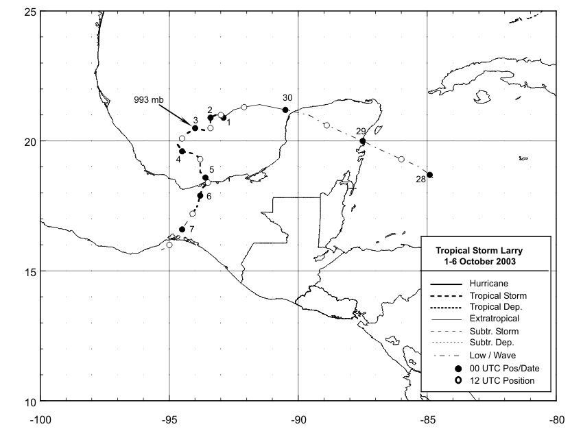
You might compare these two images:
http://myweb.cableone.net/nolasue/larry.gif
http://myweb.cableone.net/nolasue/disturb.gif
Very similar setup to Larry last September. 200mb winds are 25-40 kts from the southwest across the BOC and pressures are a few millibars higher now. Chances of tropical development are extremely remote, but not completely out of the question.
0 likes
- hurricanetrack
- HurricaneTrack.com

- Posts: 1781
- Joined: Tue Dec 02, 2003 10:46 pm
- Location: Wilmington, NC
- Contact:
That was cool
Excellent comparison there Chris. That was really cool. Hope you got some more of those where it came from for the rest of the season!
0 likes
Who is online
Users browsing this forum: Google Adsense [Bot], Ulf and 78 guests


