Things look to be heating up this weekend from the plains into the Midwest and OH/TN Valley's as alot of these areas except the northern most will see thier first taste of springtime wx with temps ranging from the 50s to the 60s bringing with those warmer temps a chance for severe wx into these areas as well as a strong low pressure ejects out of the rockies and heads thru the central plains up into the Great Lakes.
The Severe wx should start later today in western TX (Main threats' Large Hail and damaging winds)and then move out into the central/southern Plains tomorrow (Large Hail, Damaging winds, Isolated Tornadoes)and then moving ene up into the OH/TN Valley's come Monday (Large Hail, Isolated Tornadoes).
More on this later!
First springtime warmth and severe wx event this weekend????
Moderator: S2k Moderators
Forum rules
The posts in this forum are NOT official forecast and should not be used as such. They are just the opinion of the poster and may or may not be backed by sound meteorological data. They are NOT endorsed by any professional institution or STORM2K.
- wx247
- S2K Supporter

- Posts: 14279
- Age: 42
- Joined: Wed Feb 05, 2003 10:35 pm
- Location: Monett, Missouri
- Contact:
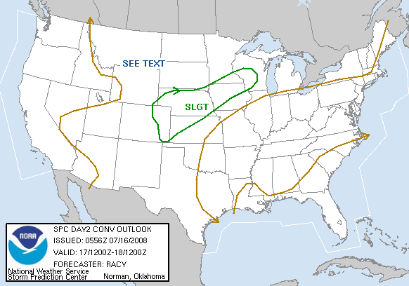
Here is tomorrow's outlook!


0 likes
Personal Forecast Disclaimer:
The posts in this forum are NOT official forecast and should not be used as such. They are just the opinion of the poster and may or may not be backed by sound meteorological data. They are NOT endorsed by any professional institution or storm2k.org. For official information, please refer to the NHC and NWS products.
The posts in this forum are NOT official forecast and should not be used as such. They are just the opinion of the poster and may or may not be backed by sound meteorological data. They are NOT endorsed by any professional institution or storm2k.org. For official information, please refer to the NHC and NWS products.
-
Guest
-
Suzi Q
- wx247
- S2K Supporter

- Posts: 14279
- Age: 42
- Joined: Wed Feb 05, 2003 10:35 pm
- Location: Monett, Missouri
- Contact:
NEWeatherguy wrote:wx247 wrote:Here is tomorrow's outlook!
I am in a GEN TSTM outlook FOR NOW... but the SLGT is not too far away!
You might have some good old fashioned thunderstorms tomorrow Brian.
0 likes
Personal Forecast Disclaimer:
The posts in this forum are NOT official forecast and should not be used as such. They are just the opinion of the poster and may or may not be backed by sound meteorological data. They are NOT endorsed by any professional institution or storm2k.org. For official information, please refer to the NHC and NWS products.
The posts in this forum are NOT official forecast and should not be used as such. They are just the opinion of the poster and may or may not be backed by sound meteorological data. They are NOT endorsed by any professional institution or storm2k.org. For official information, please refer to the NHC and NWS products.
-
Guest
wx247 wrote:NEWeatherguy wrote:wx247 wrote:Here is tomorrow's outlook!
I am in a GEN TSTM outlook FOR NOW... but the SLGT is not too far away!
You might have some good old fashioned thunderstorms tomorrow Brian.
It would be amazing if, in later outlooks, that slight is pushed just a bit further north!
0 likes
- wx247
- S2K Supporter

- Posts: 14279
- Age: 42
- Joined: Wed Feb 05, 2003 10:35 pm
- Location: Monett, Missouri
- Contact:
watch the wind fields...
lightning looks like a good bet as well.
lightning looks like a good bet as well.
0 likes
Personal Forecast Disclaimer:
The posts in this forum are NOT official forecast and should not be used as such. They are just the opinion of the poster and may or may not be backed by sound meteorological data. They are NOT endorsed by any professional institution or storm2k.org. For official information, please refer to the NHC and NWS products.
The posts in this forum are NOT official forecast and should not be used as such. They are just the opinion of the poster and may or may not be backed by sound meteorological data. They are NOT endorsed by any professional institution or storm2k.org. For official information, please refer to the NHC and NWS products.
-
Guest
- therock1811
- Category 5

- Posts: 5163
- Age: 40
- Joined: Thu May 15, 2003 2:15 pm
- Location: Kentucky
- Contact:
Return to “USA & Caribbean Weather”
Who is online
Users browsing this forum: cstrunk, SnowyOwl31, South Texas Storms and 126 guests
