WOW, What a difference a Day can make................Today we SOARED to a warm 47 degrees. I needed NO COAT at all. Now its 38 as we slowly cool off tonight.......
-Jeb
We hit a WHOPPING 47, but slowly cooling now...
Moderator: S2k Moderators
Forum rules
 The posts in this forum are NOT official forecast and should not be used as such. They are just the opinion of the poster and may or may not be backed by sound meteorological data. They are NOT endorsed by any professional institution or STORM2K.

The posts in this forum are NOT official forecast and should not be used as such. They are just the opinion of the poster and may or may not be backed by sound meteorological data. They are NOT endorsed by any professional institution or STORM2K.
-
Anonymous
-
Anonymous
WHOA THERE!!!!!!!!!!!!!!!!!!!!!!!!!!!!!
WE JUST FELL TWO DEGREES IN ONLY FOUR MINUTES!!!!
33 degrees and 10-degree dewpoints!!!!!!!!!!!!!!!!!!
EDIT!!!!!! Dewpoint just fell to 9 degrees!!!!!!
WOOOOOOO--HOOOOOOOOOO!!!!!!!!!!!!!!!!!!!
SECOND EDIT!!! WOO_HOO!!!! We just fell to 32 degrees, with 8-degree dewpoints!!! YEAH BABY, BRING IT!! BRING IT!!!
WOOOOOOO--HOOOOOOOOOO!!!!!!!!!!!!!!!!!!!!!
We might not get significant snow this winter, but I can celebrate all I want to about all this COOL, REFRESHING WEATHER!!!!!!!
WOOOOOOO--HOOOOOOOOOO!!!!!!!!!!!!!!!!!!!!!!!!
-JEB!!!!!!!!!!!!!!!!!!!!!!!! Bring that arctic weather!!!!!!!!!!!!!! YEAH!!!!!!!!!!!!!!![/b]
Last edited by Anonymous on Thu Jan 22, 2004 8:31 pm, edited 3 times in total.
0 likes
-
Anonymous
FLguy wrote:Jeb wrote:FLguy wrote:better get used to it jeb.
What do you mean? Is it about to warm up a lot?
no the below average temps.
I'm perfectly comfortable with the below-normal temps, FLguy!!!!
All I can say is BRING IT ON!!!!!!!!!!!!!!!!!!!!!!!!!!!!!!!!!!
There is NO SUCH THING AS IT BEING TOO COLD FOR JEB!!!!!!!!
C'MON, GREENLAND BLOCK?!!! WHERE IS ALL THAT COLD WEATHER AT?!!
WHERE IS ALL THAT SNOW?!! BRING IT, GREENLAND BLOCK!!!!
-JEB!!!!!!!!!!!!!!!!!!!!!!!!!! BRING THAT ICE-AGE COLD!!!!!!!!!!!!!!!! YEAH!!!!!
0 likes
-
FLguy

- Professional-Met

- Posts: 799
- Joined: Mon Dec 29, 2003 5:36 pm
- Location: Daytona Beach FL
- Contact:
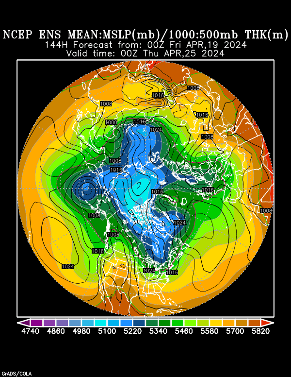
here you want some blocking jeb, check this Sh!t out:

thats INTENSE blocking centered over the davis strait at 144hrs. notice also the 50/50 low and blocking along the north shore of AK. as long as those features are in place there WILL NOT be much of a warm up for the eastern 2/3 of the nation.
we saw strong and presistent blocking along the north shore of AK last winter along with a presistently +PNA. the PNA has been more up and down so far this winter but the NAO on the other hand has been strongly negative (as discussed in the winter outlook update)
AS LONG AS THE 50/50 LOW REMAINS IN PLACE WITH STRONG BLOCKING OVER THE TOP ACROSS GREENLAND THERE WILL BE NO SOUTHEAST RIDGE.
heres the PNA ensembles:

notice some of the members now trying to take the PNA back to positive after the first of feb while the NAO just remains rediculously negative.

heres a look at the arctic oscillation verification since the 9/21/03:
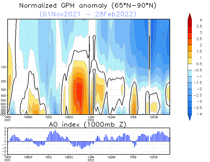
this is significant of strong blocking near the pole. which when negative (or nearly off the charts in this case) is a sign of a very cold pattern for much of north america.
now with the MJO becoming active once again means that the PAC jet is also going to get fired up toward the first week of FEB. when the PAC jet duels with a strongly -NAO like we have there is plenty of room for trouble. much like what we saw in DEC in the northeast. just this time a MUCH larger area may be impacted by a MUCH larger event.
thats INTENSE blocking centered over the davis strait at 144hrs. notice also the 50/50 low and blocking along the north shore of AK. as long as those features are in place there WILL NOT be much of a warm up for the eastern 2/3 of the nation.
we saw strong and presistent blocking along the north shore of AK last winter along with a presistently +PNA. the PNA has been more up and down so far this winter but the NAO on the other hand has been strongly negative (as discussed in the winter outlook update)
AS LONG AS THE 50/50 LOW REMAINS IN PLACE WITH STRONG BLOCKING OVER THE TOP ACROSS GREENLAND THERE WILL BE NO SOUTHEAST RIDGE.
heres the PNA ensembles:
notice some of the members now trying to take the PNA back to positive after the first of feb while the NAO just remains rediculously negative.
heres a look at the arctic oscillation verification since the 9/21/03:
this is significant of strong blocking near the pole. which when negative (or nearly off the charts in this case) is a sign of a very cold pattern for much of north america.
now with the MJO becoming active once again means that the PAC jet is also going to get fired up toward the first week of FEB. when the PAC jet duels with a strongly -NAO like we have there is plenty of room for trouble. much like what we saw in DEC in the northeast. just this time a MUCH larger area may be impacted by a MUCH larger event.
0 likes
-
Anonymous
PLUS, The OCEAN waters are MUCH colder off VA now. Hmm.......I wonder how they got that cold.....We had a COLD January!!! So the oceanic air prob is minimized and we could well have a MAJOR snow event in FEB.
I am going to be praying HARD for 36 inches of snow!!!!!!!!!!!!!!!!!!!!!!
I want my snow-filled super-cold jebwalk among the drifts so BAD!!!
AWESOME BLOCK!!!!!!!!!!!!!!!!!!!!!!!!!!!!!! AWESOME 50/50 LOW!!!!!!!!!!!!!!!
BRING IT!!! BRING IT!!! BRING IT!!!! BRING IT!!!
SHOW US NO MERCY!!! NONE!!!!! I want super-cold temps and so much snow that it shuts down the N VA metros for 3 weeks!!!!
That won't slow me down one bit; I will be out on another jebwalk!!!
BRING IT, GREENLAND BLOCK AND 50/50 LOW!!!!!!
WE DEMAND THE FULL METAL (ICE-AGE) JACKET!!!!!
NO MERCY!!!!!! SUPER-COLD WITH PARALYZING SNOWS AND HIGH WINDS AND SEVERE DRIFTING!!!
BRING IT!!!! BRING IT!!!! I AM TIRED OF THESE MICKEY-MOUSE, MILQUETOAST FRONTS!!!! LOL!!
-JEB!!!!!!!!!!!!!!!!!!!!!!!!!!!!!!!!!!!!!!!!!!!!!!!!!!!
0 likes

Who is online
Users browsing this forum: No registered users and 159 guests