THE SECOND HALF OF THE 03/04 WINTER --- WHAT DOES IT HOLD:

Winter Weather Discussion

Moderator: S2k Moderators

Forum rules

The posts in this forum are NOT official forecast and should not be used as such. They are just the opinion of the poster and may or may not be backed by sound meteorological data. They are NOT endorsed by any professional institution or STORM2K.

Help Support Storm2K
Message
Author
User avatar
FLguy
Professional-Met
Professional-Met
Posts: 799
Joined: Mon Dec 29, 2003 5:36 pm
Location: Daytona Beach FL
Contact:

THE SECOND HALF OF THE 03/04 WINTER --- WHAT DOES IT HOLD:

#1 Postby FLguy » Fri Jan 16, 2004 7:38 pm

First though….some other issues which need to be dealt with.

Admittedly ---- the southern end of my 5-10” area for the clipper a few days ago BUSTED BADLY south of the PA turnpike (I-76). North of there however I was fairly pleased with the forecast. Many locations out on long island received accumulations within the range I outlined the day before.

Not only that…it also appears that my phasing idea fore this weekend IS NOT going to verify. Why? Well for one … has anybody seen that ridiculously strong ocean low. This morning pressures were down to 948mb ---- making the system about the strength of a CATEGORY 4 HURRICANE. On another front…the system is so obscenely strong that it carried most of the coldest air away with it further east. Which is the reason why many areas in the I-95 corridor from PHL to BWI and DCA didn’t get as low as they cold have gotten IF the system were weaker. Remember folks low pressure systems are like enormous suction cups. They like to pull air inward toward them and the stronger the system is the better able it will be to do so. This is one hell of an ocean low and one of the strongest I have seen in some time. The great Appalachian storm was an example of one in which the system its self was so strong that the warm sector actually was located on the northern side of the system and all the snow fell on the southern side with cold air advection coming in from a south and southeast direction. A VERY amazing scenario. Now if only we could take that HUGE ocean low and park it off the Delmarva about 20mb weaker (in the 968-970mb range)…then we would be talking lol.

In any case the main reason or the lack of phasing is the northern branch…which thanks to the strong and displaced PV has NOT allowed for a whole lot in the way of digging. Now if the PV was located further north and weaker it would allow the jet to relax and system would then be allowed to dig more. The problem also has been the fast train of s/w energy coming through the ridge (either up and over the PNA ridge or they undercut it which takes the ridge and forces it eastward…before re-building and then the cycle repeats its self). In other words the PJ is TOO STRONG that as soon as one prospective piece of s/w energy comes through the flow its kicked along by another and then the same thing happens to that. Phasing DOES occur but offshore. So we would definitely need to see the PJ version of Amtrak get derailed before we can expect to see any kind of phasing with the STJ.

What would have been needed for phasing to occur with the STJ feature this weekend is the trough splitting in the PJ with the first piece of s/w energy weaker and the second stronger and the STJ energy its self would have had to come out AHEAD of the PJ energy in order for phasing to occur. IF the PJ energy comes out BEFORE the STJ energy the STJ s/w will be crushed or the STJ energy is left behind. In the case that the STJ s/w is kicked out ahead of the digging PJ energy phasing would occur and a major storm would ensue. The strong PV of recent of course didn’t help matters any since the jet tightens underneath it and most s/w energy which comes through the flow is 1) not allowed to dig … 2) if it is too close to the PV the jet will shear it apart.

The clipper was an example of a strong s/w which was just far enough south that it avoided the jet associated with the PV and was actually allowed to sustain its self VERY well. But of course it was much stronger than what is normal for a system.

Now don’t get me wrong we have SOME….AND THATS THE KEY WORD HERE…SOME of the right ingredients for phasing

1) The recently re-energized STJ sending plenty of energy out.

2) Tanked NAO (which is they way it has been much of the winter thus far)

3) The strong PV now becoming relocated in a more climatologically normal position (and weaker) as compared to suppressed off to the southeast over SE Canada…Newfoundland or northern new England. Which are ridiculous positions for the PV at any time of year in the first place.

When the PV is located in these positions it forces whatever s/w energy coming through the flow to be shunted out to sea quickly. Thus no amplification of the s/w can take place and the system does not close off in the mid and upper levels.

The system this weekend will have a nice swath of snow with it up into PA / NJ / SE NY / NYC and LI once again (probably 1-3” on the average) as the handoff takes place but not much more than that. Across the mid-Atlantic (south of the PA/MD border) too much warm air may be preset to allow for an all snow situation so even with higher QPFs not much snow will fall. there will be more in the way of IP / FRZRA / RA instead.

Its impossible to isolate the exact behavior of one system which would allow or phasing to take place since there are many different scenarios which would lead to such events but if we look at the overall pattern there is only one CRITICAL feature missing and that is a sustainable PNA ridge to cutoff or temporarily hold off the PJ express so that one PJ s/w coming through the flow doesn’t have that much energy on its heels ---- kicking it out too quickly. Which if there isn’t anything following in too close behind it will be allowed to dig more and POSSIBLY phase.

Now one of the driving features behind the very strong PJ and overall La Nina look to the pattern in spite of the SSTA in the equatorial PAC has been the negative (east) QBO. The QBO switched back to the east phase in DEC 02...peaked in AUG 03 and is currently at
-11.38 for the month of DEC 03. This is indicative of a QBO which is east and increasing west. This net change in the QBO index was +6.48 between NOV and DEC of 03 as compared to a net change of only +2.48 between OCT and NOV of 03. So yes the QBO is RAPIDLY increasing west. FEB should be a transitional month for the QBO (VERY weak east to start then reversal to west by the end of the month) but the point here is that the QBO will largely be neutral or near neutral in FEB. Then solidly positive (west) in MAR. What would this mean? well for one the strong dominating PJ would tend to slow down and relax (as the west phase of the QBO is correlated to a weaker PJ). 2) better potential for phasing…and 3) a better likelihood for a major east coast snow event or more than one.

Weak QBO values between +/-10.00 are usually correlated best with an INCREASED likelihood for a major east coast snow event. That said…the signal its self is weak so as we saw in December…IF other occurrences favor a major east coast snow event then it will happen … if not then the QBO signal wont mean poop. Here is a link to the QBO data from the CDC:

http://www.cdc.noaa.gov/correlation/qbo.data

Now what about our water temperature profile in the north PAC ---- well we still have the cold pool but as we notice it has begun shifting west and slight warming is now beginning to show up along the west coast of north America:

https://www.fnmoc.navy.mil/products/OTI ... nomaly.gif

This argues for low pressure near the Aleutians and a downstream PNA ridge. Now of course this is no where near along the lines of what we saw in 1993-94 and last winter but it is more heavily weighted toward a +PNA. The warm water east of Japan and arm pool near 180 in the equatorial PAC support this trend as well.

Heres the latest AGCM run from JAN 6:

200 hPa heights:

Image

SFC temps:

Image

Notice the negative anomaly sitting to the southwest of the Aleutians with the strong blocking over the top and to the east of it. This would imply a +PNA in the means…however the signal is much more variable than it was in the 1993-94 and 2002-03 winters so the +PNA will NOT dominate the pattern. However with the QBO going west theres LESS likelihood that the trough will once again get pulled back into the western US for any appreciable amount of time.

The warm water out near 180 is also supportive of a +PNA and a very cold pattern for the EUS.

Now what to do about the developing El Nino. A series of Kelvin waves moved eastward across the tropical PAC which contributed to some warming. However over the past month the warmest SSTA have been located close to and just west of 180 and on the order of +0.5 and +1.5C:

http://www.cdc.noaa.gov/map/images/sst/ ... .month.gif

The other three NINO regions (1+2...3.0...and 3.4) have been running near normal. Heres a text representation of SSTA totals and anomalies since the second week of DEC:

10 DEC 2003 22.9 .3 25.5 .4 27.0 .5 29.1 .9
17 DEC 2003 23.0 .1 25.4 .3 26.8 .4 29.0 .7
24 DEC 2003 23.0 -.2 25.6 .4 26.8 .3 28.9 .6
31 DEC 2003 23.8 .2 25.7 .4 26.7 .2 28.7 .5
07 JAN 2004 24.2 .2 25.7 .3 26.6 .1 28.7 .5

And on a monthly time scale (text format):

2003 10 20.99 .08 25.33 .43 29.22 .81 27.19 .60
2003 11 21.92 .27 25.40 .45 29.31 .95 27.05 .53
2003 12 22.99 .15 25.56 .47 29.02 .75 26.89 .42

Graphical representation:

Image

SSTA have decreased substantially since OCT in the Equatorial PAC but still as of now remain ABOVE normal. In DEC 03 the Nino 1+2 region was running +0.15C…Nino 3.0 was around +0.47 the Nino 3.4 region was about +0.42 and the 4.0 region close to +0.75. Now that said the Nino 3.4 values WOULD be supportive of a major east coast snowstorm development. And true to form ---- we saw it happen. And that was with a strong east QBO.

ftp://ftpprd.ncep.noaa.gov/pub/cpc/wd52 ... /wksst.for
ftp://ftpprd.ncep.noaa.gov/pub/cpc/wd52 ... oi.indices

The NCEP model continues to indicate the development of El Nino conditions but due to the concurrent long term PDO cold cycle…and inconsistencies in the SOI and frequent fluctuations in SSTA across the tropical PAC. Heres the latest run of the NCEP ENSO model from this past Tuesday:

Monthly SSTA forecast:

Image

Three month mean:

Image

Notice how it has backed off slightly on the warming from the past several runs. Even with that said IF a weak to moderate El Nino does develop it WILL NOT be located close to the south America coast. this type of “classic” El Nino is NOT favored in the long term PDO cold cycle. It would be centered in the central or western equatorial PAC (much in conjunction with where the warmest SSTA been for the past 6 months).
I DO think a weak El Nino will develop in the next 4-8 weeks but it will not be a classic one. Something more consistent with what was seen last winter is a better bet as far as placement of the warm pool is concerned however it should not be as strong.

Sub-surface ocean temps and anomalies have not changed much in the past few weeks. Notice in the figure below the best warming is located across the western equatorial PAC which is normal (climatologically speaking and for ENSO neutral conditions) as far as placement is concerned however temps are running above normal and the 20C isotherm depth is between 150 and 200 meters west of 180.
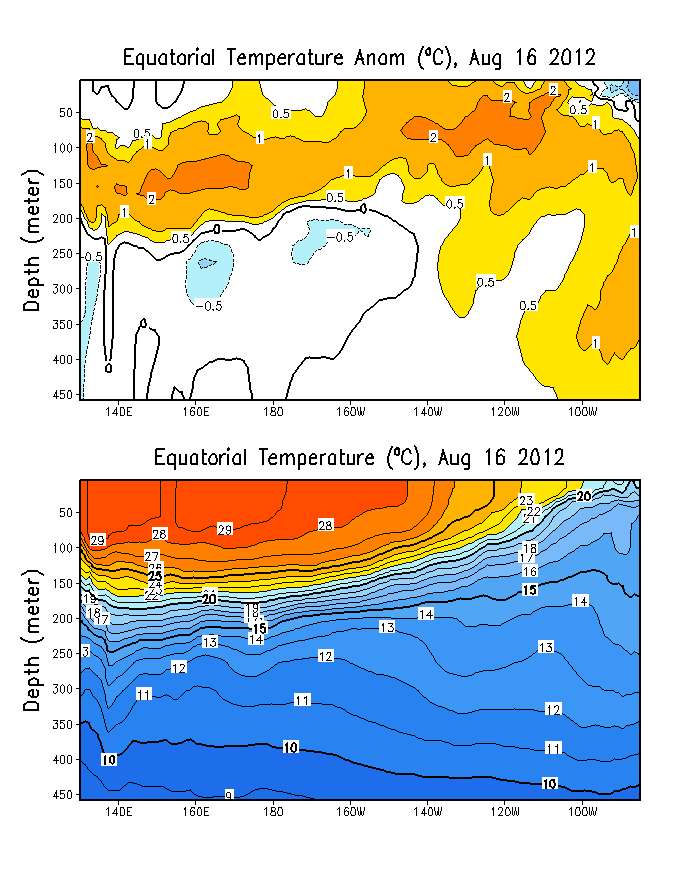
Image

Time-longitude section of the anomalous equatorial depth of the 20C since last FEB:
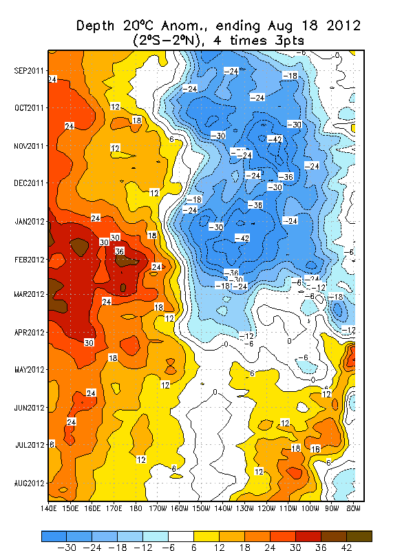
Image

With the QBO switching to west and the eventual evolution toward WEAK EL NINO conditions the second half of the winter is looking VERY FUN for the Midwest and northeast. The QBO signal…equatorial PAC SSTA in the NINO 3.4 region do favor one if not more major east coast snow events. And to answer a question in another thread…The first of which may come in the second week of FEB with another closer to the end of the month and then a final event to close out the winter in early march.

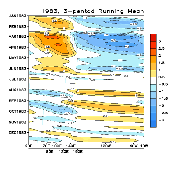
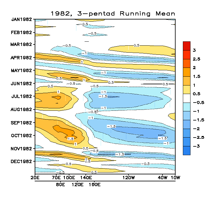
Meanwhile with the MJO related convection east of 180 I see no reason why the STJ would relax (other than the reversal of the SOI back to positive). Once things switch around and the enhanced convection sets up around 120E we should see the PAC jet firehouse get cranking again and the STJ shut off. Normally in other winds when we see an unrelenting STJ (like 1982/83) the MJO is relatively inactive (which is also normal for strong El Nino years):

1982:
Image

1983:

Image

Notice that as the strong El Nino took shape the result was the MJO becoming relatively inactive however the enhanced convection remained east of 180 which supported the unrelenting STJ.

In summary I expect that the eastern 2/3 of the nation east of the Rockies will continue to see normal to below normal tempos through much of the rest of the winter with an INCREASING probability of something BIG snow wise in the next few weeks given the state of in the factors discussed above.
0 likes   

User avatar
Chris the Weather Man
Category 2
Category 2
Posts: 746
Joined: Fri Dec 12, 2003 9:49 pm
Location: NJ

#2 Postby Chris the Weather Man » Fri Jan 16, 2004 7:56 pm

My Lord! FLguy!! Amazlingly Great Post! 1 problem I am not a met! Therefore, I will need some help understanding this........... :wink: :)
Last edited by Chris the Weather Man on Fri Jan 16, 2004 7:58 pm, edited 2 times in total.
0 likes   

User avatar
2001kx
Tropical Storm
Tropical Storm
Posts: 156
Joined: Sat Nov 22, 2003 2:00 am
Location: 50 miles north west of st.college(C-PA)

#3 Postby 2001kx » Fri Jan 16, 2004 7:57 pm

nice write-up,thanks
waiting on a big one :wink:
0 likes   

User avatar
Stormsfury
Category 5
Category 5
Posts: 10549
Age: 53
Joined: Wed Feb 05, 2003 6:27 pm
Location: Summerville, SC

#4 Postby Stormsfury » Fri Jan 16, 2004 8:21 pm

Great post and excellent discussion, FLguy ..

For example, the PJ is wreaking havoc on MR forecasts, and caused the nightmares that I'm having forecasting events from farther than 4 days out ... the fact of the matter is that the models simply cannot catch up to the speeds of the raging PJ and thusly, outputs and consistency continue to lack until the PJ relaxes.

Now, another great point from FLguy... The QBO is dropping into the single digits and CLEARLY getting read to see the Westerly Phase kick in within a month. And the Kelvin waves that have recently been observed with the MJO phase kicking in also suggest that the southern branch (SBJ) is about to kick in. All the models continue to prog the return of storminess and ALL the signs continue to point to that ...

The question remains will the cold air remain when the storminess kicks in? Initially, I believe so .. and we MAY not have to wait long ...

SF
0 likes   

User avatar
Stephanie
S2K Supporter
S2K Supporter
Posts: 23843
Age: 63
Joined: Thu Feb 06, 2003 9:53 am
Location: Glassboro, NJ

#5 Postby Stephanie » Fri Jan 16, 2004 8:34 pm

FANTASTIC ANALYSIS!

SF - to be continued huh???
0 likes   

ColdFront77

#6 Postby ColdFront77 » Fri Jan 16, 2004 8:36 pm

How can you read these long posts with not spending as much time as me online???

There are other threads in this forum and other forums to read as well as checking weather related and non-weather related websites.
Last edited by ColdFront77 on Fri Jan 16, 2004 9:51 pm, edited 2 times in total.
0 likes   

donsutherland1
S2K Analyst
S2K Analyst
Posts: 2718
Joined: Mon Sep 15, 2003 8:49 pm
Location: New York

Re: THE SECOND HALF OF THE 03/04 WINTER --- WHAT DOES IT HOL

#7 Postby donsutherland1 » Fri Jan 16, 2004 8:50 pm

Great discussion, FLguy.

With the QBO in transition toward a West phase and the possibility of a weak or borderline El Nino in the West Pacific, the ingredients are falling into place for an exciting conclusion to winter.

These factors, which you describe so well in your post, the historic patterns pertaining to snowfall with respect to December snowfall and early-season significant snowfall, all point to such cities as NYC and Boston seeing above to much above normal snowfall for the season. Already, NYC is closing in on its first back to back 30" seasons in 33 years and perhaps its first consecutive 40" seasons in 45 years. Boston should more than double its snowfall to date.
0 likes   

Anonymous

#8 Postby Anonymous » Fri Jan 16, 2004 9:49 pm

Stormsfury wrote:Great post and excellent discussion, FLguy ..

For example, the PJ is wreaking havoc on MR forecasts, and caused the nightmares that I'm having forecasting events from farther than 4 days out ... the fact of the matter is that the models simply cannot catch up to the speeds of the raging PJ and thusly, outputs and consistency continue to lack until the PJ relaxes.

Now, another great point from FLguy... The QBO is dropping into the single digits and CLEARLY getting read to see the Westerly Phase kick in within a month. And the Kelvin waves that have recently been observed with the MJO phase kicking in also suggest that the southern branch (SBJ) is about to kick in. All the models continue to prog the return of storminess and ALL the signs continue to point to that ...

The question remains will the cold air remain when the storminess kicks in? Initially, I believe so .. and we MAY not have to wait long ...

SF


That, SF, is the BIG QUESTION of the hour.......................

Will the cold air remain when the storminess kicks in?

I have another question......

When the storminess kicks in (and there is NO question in my mind, that the storminess WILL kick in), Will there still be a supply of cold air up an Canada and will the storms be able to tap it? When the storminess kicks back in here in the East, WILL 1040MB highs be able to funnel cold air south so we obtain CAD east of the Apps and thus develop the sort of set-up that will then allow us to get absolutely CLOCKED by crippling snows with absolutely no prospect of mercy, just like I want so badly? Will I finally get to dig out of a huge crippling snow here in Woodbridge? Will I FINALLY get to enjoy my long-awaited jebwalk among the drifts, having a hard time walking because of plowed piles of snow along all roads and be forced to pick my way along all during the jebwalk for which I have yearned and waited all winter long?

Is there really any chance of N VA really getting a nice big snow, and NOT getting shafted by warm 55 degree weather only 2 days after the event? All I ever wanted was a chance to enjoy my precious snowy jebwalk, to have my precious winter jebwalk and to be blasting all the hundreds of CDs that I have associated with snow since I was only a small kid, while enjoying my jebwalk among the snowdrifts, looking at all the piles of snow with my jaw resting on the snowy ground in utter amazement and blasting my CD songs and enjoying a truly epic jebwalk in the snow at long last.

That precious jebwalk in the snow is all I truly care about; jebwalks are now at the very center of my life. I have set everything else aside forever, to the dismay of my Christian friends at church. They can see all the classic signs of the jebwalk taking over in my life. Many singles in our church group are getting married; I continue to walk as I have for the past 33 years or so with no signs of ever stopping.

I love my precious jebwalk in the snow.

Oh please let 36 inches of snow descend upon Woodbridge. Then, I will have it made. The guy you see walking in the snow in the fierce, biting cold.......That will be Jeb, enjoying yet another jebwalk in the snow. :) :)


I can only hope and pray.


-JEB
0 likes   

User avatar
Chris the Weather Man
Category 2
Category 2
Posts: 746
Joined: Fri Dec 12, 2003 9:49 pm
Location: NJ

#9 Postby Chris the Weather Man » Fri Jan 16, 2004 10:24 pm

Wow, Jeb, You really want that 36 inches inches! Dang! lol.... You should have seen my house after the President Day blizzard, on my porch, about 35-38 inches of snow on it! :eek: :)
0 likes   

User avatar
WEATHER53
Category 1
Category 1
Posts: 470
Joined: Mon Sep 15, 2003 10:43 pm
Location: College Park, MD

#10 Postby WEATHER53 » Fri Jan 16, 2004 11:57 pm

I do not see a protracted, more than 2 day, mild up for DC area anytime this month so the next question is will it continue cold in Feb and right now I believe Feb will also continue a below normal trend. However, our original idea of 12-15" of snow for Dec-Feb at DCA we still believe in, no big storms, none more than 4-5", and it is possible that DCA has already seen it's biggest snow event. Big cold still in the cards, big snow not.
0 likes   

User avatar
FLguy
Professional-Met
Professional-Met
Posts: 799
Joined: Mon Dec 29, 2003 5:36 pm
Location: Daytona Beach FL
Contact:

#11 Postby FLguy » Sat Jan 17, 2004 8:03 pm

WEATHER53 wrote:I do not see a protracted, more than 2 day, mild up for DC area anytime this month so the next question is will it continue cold in Feb and right now I believe Feb will also continue a below normal trend. However, our original idea of 12-15" of snow for Dec-Feb at DCA we still believe in, no big storms, none more than 4-5", and it is possible that DCA has already seen it's biggest snow event. Big cold still in the cards, big snow not.


WEATHER53 --- on temperatures i agree...when it comes to your snowfall ideas i couldint disagree more. there is absolutely NO SUPPORT at least IMO for the idea that no storms will produce more than 4-5" of snow at DCA. if anything the overall pattern is becoming MORE favorable as we head into FEB and MAR for a major event than it was in DEC or early this month. as far as the totals for the season are concerned...IMO double that. IF your right (which is possible though not likely)...its luck.
0 likes   

User avatar
Chris the Weather Man
Category 2
Category 2
Posts: 746
Joined: Fri Dec 12, 2003 9:49 pm
Location: NJ

#12 Postby Chris the Weather Man » Sat Jan 17, 2004 8:52 pm

I have a feeling that the major storm will be comming in March, ( But Yet, I am no met. we shall see. I hope sooner!)
0 likes   

weatherfan
Tropical Depression
Tropical Depression
Posts: 89
Joined: Wed Dec 17, 2003 7:50 pm

Be carefull here Flguy.

#13 Postby weatherfan » Sat Jan 17, 2004 10:32 pm

Flguy very good post all those I will have to trend to disagree with you on one point.And the point of The reason is.Mid Febuarey-March periold is going to be on the hands on what happens with the ENSO.if we get an El nino to come on Mid Febuarey.And the QBO changes to west.Then that will mean a very cold and stromey and snowey end to winter.However if we stay nurtrul and El nino does it come on.Then its very likey that we will not see a cold and stormey Mid Febuarey and March and instread spring comes early.If you look at HM post on the other board Wright-weather he gives a good explannion on the set ups that have to happen to have a cold and stormey pattern to end the winter on.So all eyes will be on the ENSO to see if 1.We get El nino West or east to form and winter gos out with a bang.Or we stay nurtrul and spring comes early.Still many question that have to be anwered so that why Flguy I'm just trying to egred a bit of couation.But over all a very good and detail post.
0 likes   

User avatar
FLguy
Professional-Met
Professional-Met
Posts: 799
Joined: Mon Dec 29, 2003 5:36 pm
Location: Daytona Beach FL
Contact:

#14 Postby FLguy » Sat Jan 17, 2004 10:53 pm

well even with that said tonights ECM would have a NASTY overrunning event for most of the mid-atlantic and northeast in the 24-28th timeframe.

http://web.wright-weather.com/wxp-model ... t_h144.gif

notice the pos tilted trough and corresponsing STJ s/w hanging back across northwest mexico at 144 hrs...the upstream s/w moving southeast down down the west coast of north america on the western side of the ridge digs in and kics the STJ s/w out of NW mexico into the southern plains at 168hrs:

http://web.wright-weather.com/wxp-model ... t_h168.gif

Notice the position of the PV has become established MUCH FURTHER NORTH than what it had been near western Baffen island canada.

as the STJ s/w kicks out into the southern plains in response to the energy digging into the west...surface cyclogenesis takes place in the western gulf of mexico close to the TX coast.

http://web.wright-weather.com/wxp-model ... 68_500.gif

850 temps across the mid atlantic and northeast are MORE than cold enough to support wintry precipitation in an overrunning situation. though the details are sketchey at best right now.

http://web.wright-weather.com/wxp-model ... 68_850.gif

with the PV located futher north and the nothern branch slowing down its possible that this COULD become quite an event for much of the mid-atlantic and Northeast.

the EXTREMELY cold pattern in the east is coming to an end...though by no means are things going to get warm over the next 10 days. the retrogression of the pattern suggests that the ridge re-develops off the west coast in the next 7-10 days...and the trough gets back in WEST of hawaii which would suggest that the trough in the east is pulled back into the nations midsection and then the western part of the country temporarly. so we may see the SE ridge make a slight comback with time...though i DONT think it lasts long.

the wild card in this is the NAO which has been negative most of the winter and the SSTA set-up in the atlantic suggests tha the NAO continues to be mostly negative for some time to come. a -NAO would try to hold the trough in the east even in spite of the changes in the PAC pattern whioch says the trough retrogrades back to the west.

well see what happens.
0 likes   

User avatar
FLguy
Professional-Met
Professional-Met
Posts: 799
Joined: Mon Dec 29, 2003 5:36 pm
Location: Daytona Beach FL
Contact:

Re: Be carefull here Flguy.

#15 Postby FLguy » Sat Jan 17, 2004 11:04 pm

weatherfan wrote:Flguy very good post all those I will have to trend to disagree with you on one point.And the point of The reason is.Mid Febuarey-March periold is going to be on the hands on what happens with the ENSO.if we get an El nino to come on Mid Febuarey.And the QBO changes to west.Then that will mean a very cold and stromey and snowey end to winter.However if we stay nurtrul and El nino does it come on.Then its very likey that we will not see a cold and stormey Mid Febuarey and March and instread spring comes early.If you look at HM post on the other board Wright-weather he gives a good explannion on the set ups that have to happen to have a cold and stormey pattern to end the winter on.So all eyes will be on the ENSO to see if 1.We get El nino West or east to form and winter gos out with a bang.Or we stay nurtrul and spring comes early.Still many question that have to be anwered so that why Flguy I'm just trying to egred a bit of couation.But over all a very good and detail post.


theres no question the QBO will switch west and ive already explained what i believe will happen in regard to the ENSO.
0 likes   

User avatar
Chris the Weather Man
Category 2
Category 2
Posts: 746
Joined: Fri Dec 12, 2003 9:49 pm
Location: NJ

#16 Postby Chris the Weather Man » Sat Jan 17, 2004 11:45 pm

Nasty Overrunning? Major Nor'Easter? = PD Storm Part 2?
0 likes   

User avatar
FLguy
Professional-Met
Professional-Met
Posts: 799
Joined: Mon Dec 29, 2003 5:36 pm
Location: Daytona Beach FL
Contact:

#17 Postby FLguy » Sun Jan 18, 2004 12:03 am

Chris the Weather Man wrote:Nasty Overrunning? Major Nor'Easter? = PD Storm Part 2?


PDS 2 was NOT a major nor'easter. the coastal low was absolutely pathetic pressure wise. the event was characterized by large scale isentropic ascent (warm air advection) in the face of a rather strong ageostrophic component courtesy of the strong high to the north which kept the cold air in place. it was much like the blizzard of 83...one of my favoite major east coast snowstorms of all time.

not to mention that the system originated in the tropical PAC and never lost its tropical moisture feed. it was a classic example of a situation where if you can predict the behavior of the high you can predict the storm. if that high was not there PDS 2 would have never happened.
0 likes   

User avatar
Chris the Weather Man
Category 2
Category 2
Posts: 746
Joined: Fri Dec 12, 2003 9:49 pm
Location: NJ

#18 Postby Chris the Weather Man » Sun Jan 18, 2004 12:08 am

Ahh, Now I get it now, FLguy........ Would love to see another Superstorm of 1993............... 968 mb! :eek:
0 likes   

User avatar
FLguy
Professional-Met
Professional-Met
Posts: 799
Joined: Mon Dec 29, 2003 5:36 pm
Location: Daytona Beach FL
Contact:

#19 Postby FLguy » Sun Jan 18, 2004 12:31 am

Chris the Weather Man wrote:Ahh, Now I get it now, FLguy........ Would love to see another Superstorm of 1993............... 968 mb! :eek:


the superstorm of 1993 would have been 10x WORSE if the track of the surface low was as little as 50-100 miles east of what it was. that would have kept the major cities all or mostly all snow.

heres some surface data from march 12-15 1993:

surface data and SLP valid 12z 4/12/93:

http://ww2010.atmos.uiuc.edu/(Gh)/arch/cases/930312/sfc/gifs/us/93031212.gif

surface data and SLP valid 12z 4/13/93:

http://ww2010.atmos.uiuc.edu/(Gh)/arch/cases/930312/sfc/gifs/us/93031312.gif

surface data and SLP valid 06z 4/14/93:

http://ww2010.atmos.uiuc.edu/(Gh)/arch/cases/930312/sfc/gifs/us/93031406.gif

surface data and SLP valid 06z 4/15/93:

http://ww2010.atmos.uiuc.edu/(Gh)/arch/cases/930312/sfc/gifs/us/93031506.gif

heres two great reviews of the March 1993 superstorm from the NCDC (PDF file):

ftp://ftp.ncdc.noaa.gov/pub/data/techrp ... tr9301.pdf
http://www.stormsfury1.com/Weather/Wint ... storm.html

heres a few H5 maps from the event:

Image

Image

Image

Image

Image

total snowfall:

Image
0 likes   

sertorius
Category 2
Category 2
Posts: 640
Joined: Fri Dec 26, 2003 2:52 pm
Location: Lawrence, Kansas

#20 Postby sertorius » Sun Jan 18, 2004 9:30 am

I just hope things change a bit for the central plains (Kansas and Western Missouri) for the second half of winter-we will have some chilly air for the next couple of days and then its back to the 40's and 50's starting Friday. The GFS and Euro are hinting at some possibilities for next week, but it seems the cold air still wants to head farther east and not really establish itself here in "Middle America". There have been several posts about Artic air into Texas next week, but it just seems the models really want to carry Pacific Air into here with the bulk of the cold going East. Honestly, while we have in the past had some blockbuster Feb. (quite a few actually) it does get harder to get storms in here as we really warm up quickly on a south west/westerly flow. Also, our NWS is discussing the split flow for this week with the trough in the West putting us very warm for next weekend. In the end, the weather will do what the weather will do-thank goodness-if we had a say in it, we would never have snow!!! One can always hope and dream-I guess that's what the GFS is for!! Well, I'm off to enjoy the few cold days I have-we have matched our snow total from last winter-8 inches- (14 below normal!!!) so I shouldn't complain too much!! have a great day everyone-enjoy the interesting weather in the East-this is def. your winter!!!!
0 likes   


Return to “Winter Weather”

Who is online

Users browsing this forum: wxman22 and 12 guests