Conditions indicated by the ECMWF looking very promising for the Southland/Southeast with cold sprawling high pressure from Canada meeting up with a s/w from the southern stream ... more details at
http://www.stormsfury1.com/
(As usual - My forecast/Prognostic Discussions)
SF
ECMWF VERY INTERESTING for Southland/Southeast in MR...
Moderator: S2k Moderators
Forum rules
 The posts in this forum are NOT official forecast and should not be used as such. They are just the opinion of the poster and may or may not be backed by sound meteorological data. They are NOT endorsed by any professional institution or STORM2K.

The posts in this forum are NOT official forecast and should not be used as such. They are just the opinion of the poster and may or may not be backed by sound meteorological data. They are NOT endorsed by any professional institution or STORM2K.
-
Stormsfury

- Category 5

- Posts: 10549
- Age: 53
- Joined: Wed Feb 05, 2003 6:27 pm
- Location: Summerville, SC
-
Stormsfury
- Category 5
- Posts: 10549
- Age: 53
- Joined: Wed Feb 05, 2003 6:27 pm
- Location: Summerville, SC
-
FLguy

- Professional-Met

- Posts: 799
- Joined: Mon Dec 29, 2003 5:36 pm
- Location: Daytona Beach FL
- Contact:
Re: ECMWF VERY INTERESTING for Southland/Southeast in MR...
Stormsfury wrote:Conditions indicated by the ECMWF looking very promising for the Southland/Southeast with cold sprawling high pressure from Canada meeting up with a s/w from the southern stream ... more details at
http://www.stormsfury1.com/
(As usual - My forecast/Prognostic Discussions)
SF
agreed. and great discussion as always.
small side note...
the cold which now confined to the northeast will begin to spread south and west with time so while the northeast will warm relative to what it has been recently (with record setting and near HISTORIC cold) things will warm up (compared to the present...not to normal) while the midwest and southeast cool relative to what it has been in the next week to two weeks.
0 likes
-
Anonymous
-
Stormsfury
- Category 5
- Posts: 10549
- Age: 53
- Joined: Wed Feb 05, 2003 6:27 pm
- Location: Summerville, SC
Jeb wrote:Hey SF.......what could this mean for North Carolina and Virginia?
-JEB
Taken Literally, AL/GA/Carolinas look good ... with VA possibly getting into the action as well ... Best 850mb and 700mb RH's are over AL/GA (near the 850mb LOW) and a good stripe of >90% through South Carolina ... it APPEARS that this will phase offshore but hard to decipher with 3 day averages for Day 8-10 ... BUT LOOK OUT WEST, the pattern remains very similar and WHAT? Maybe another event afterwards?
The overall theme is this ... ALL the globals and the associated ensembles are progging, and portraying a return to a stormy pattern across the US ...
Notice this ... the WESTERLY burst from the KELVIN WAVE in the EPAC is now EAST of the INT DATE LINE with the MJO phase, and would also suggest (and support) the return of a stormier pattern ... notice the warmest anomalies (if you can call it warm coincide nicely to the WESTERLY wind burst).
Also, that same WEST wind course disrupts the normal trades and the decreases the cold upwelling that's been occurring across the EQ PAC ... there's a possibility that within the next month or two, we begin to see some real signs of the progged El Niño.


0 likes
-
Anonymous
-
FLguy
- Professional-Met
- Posts: 799
- Joined: Mon Dec 29, 2003 5:36 pm
- Location: Daytona Beach FL
- Contact:
Stormsfury wrote:Jeb wrote:Hey SF.......what could this mean for North Carolina and Virginia?
-JEB
Taken Literally, AL/GA/Carolinas look good ... with VA possibly getting into the action as well ... Best 850mb and 700mb RH's are over AL/GA (near the 850mb LOW) and a good stripe of >90% through South Carolina ... it APPEARS that this will phase offshore but hard to decipher with 3 day averages for Day 8-10 ... BUT LOOK OUT WEST, the pattern remains very similar and WHAT? Maybe another event afterwards?
The overall theme is this ... ALL the globals and the associated ensembles are progging, and portraying a return to a stormy pattern across the US ...
Notice this ... the WESTERLY burst from the KELVIN WAVE in the EPAC is now EAST of the INT DATE LINE with the MJO phase, and would also suggest (and support) the return of a stormier pattern ... notice the warmest anomalies (if you can call it warm coincide nicely to the WESTERLY wind burst).
Also, that same WEST wind course disrupts the normal trades and the decreases the cold upwelling that's been occurring across the EQ PAC ... there's a possibility that within the next month or two, we begin to see some real signs of the progged El Niño.
http://www.pmel.noaa.gov/tao/jsdisplay/ ... y_ps32.gif
https://www.fnmoc.navy.mil/products/OTI ... nomaly.gif
right and as long as the convection is east of 120E the STJ will not relax. meanwhile the supressed convection near 120E implies that the PNA ridge isnt going away anytime soon.
0 likes
-
Stormsfury
- Category 5
- Posts: 10549
- Age: 53
- Joined: Wed Feb 05, 2003 6:27 pm
- Location: Summerville, SC
Re: ECMWF VERY INTERESTING for Southland/Southeast in MR...
FLguy wrote:Stormsfury wrote:Conditions indicated by the ECMWF looking very promising for the Southland/Southeast with cold sprawling high pressure from Canada meeting up with a s/w from the southern stream ... more details at
http://www.stormsfury1.com/
(As usual - My forecast/Prognostic Discussions)
SF
agreed. and great discussion as always.
small side note...
the cold which now confined to the northeast will begin to spread south and west with time so while the northeast will warm relative to what it has been recently (with record setting and near HISTORIC cold) things will warm up (compared to the present...not to normal) while the midwest and southeast cool relative to what it has been in the next week to two weeks.
Especially since the center of the PV currently is severely displaced over NE ... WOW, Boston already at -1º, and
MT WASHINGTON at 9 pm - -42º, wind chill -98º!!!
Northwest Winds at 81 mph, gusting to 93 mph!!!! Weather --- ICE FOG...
SF
0 likes
-
FLguy
- Professional-Met
- Posts: 799
- Joined: Mon Dec 29, 2003 5:36 pm
- Location: Daytona Beach FL
- Contact:
Re: ECMWF VERY INTERESTING for Southland/Southeast in MR...
Stormsfury wrote:FLguy wrote:Stormsfury wrote:Conditions indicated by the ECMWF looking very promising for the Southland/Southeast with cold sprawling high pressure from Canada meeting up with a s/w from the southern stream ... more details at
http://www.stormsfury1.com/
(As usual - My forecast/Prognostic Discussions)
SF
agreed. and great discussion as always.
small side note...
the cold which now confined to the northeast will begin to spread south and west with time so while the northeast will warm relative to what it has been recently (with record setting and near HISTORIC cold) things will warm up (compared to the present...not to normal) while the midwest and southeast cool relative to what it has been in the next week to two weeks.
Especially since the center of the PV currently is severely displaced over NE ... WOW, Boston already at -1º, and
MT WASHINGTON at 9 pm - -42º, wind chill -98º!!!
Northwest Winds at 81 mph, gusting to 93 mph!!!! Weather --- ICE FOG...
SF
i think we should send Jeb there...lol
0 likes
-
Anonymous
Re: ECMWF VERY INTERESTING for Southland/Southeast in MR...
FLguy wrote:Stormsfury wrote:FLguy wrote:Stormsfury wrote:Conditions indicated by the ECMWF looking very promising for the Southland/Southeast with cold sprawling high pressure from Canada meeting up with a s/w from the southern stream ... more details at
http://www.stormsfury1.com/
(As usual - My forecast/Prognostic Discussions)
SF
agreed. and great discussion as always.
small side note...
the cold which now confined to the northeast will begin to spread south and west with time so while the northeast will warm relative to what it has been recently (with record setting and near HISTORIC cold) things will warm up (compared to the present...not to normal) while the midwest and southeast cool relative to what it has been in the next week to two weeks.
Especially since the center of the PV currently is severely displaced over NE ... WOW, Boston already at -1º, and
MT WASHINGTON at 9 pm - -42º, wind chill -98º!!!
Northwest Winds at 81 mph, gusting to 93 mph!!!! Weather --- ICE FOG...
SF
i think we should send Jeb there...lol
That sounds really great!
When do I leave? At least there they don't get Mickey-Mouse -15 temps!!!!
Minus 42 is decent winter weather, Nice and crisp, and I sure know I can still take MY trash out!!!! Mainers!!! Can't even deal with moderate winter Arctic Outbreaks!!!
Yeah when do we leave for Mt Washington?
No more mild highs of 36 like today!!!!!
-SIBERIAN CROSS POLAR SNOW BLITZ JEB!!!!!!! BRING IT!!! NO MERCY!!!
0 likes
-
Stormsfury
- Category 5
- Posts: 10549
- Age: 53
- Joined: Wed Feb 05, 2003 6:27 pm
- Location: Summerville, SC
-
FLguy
- Professional-Met
- Posts: 799
- Joined: Mon Dec 29, 2003 5:36 pm
- Location: Daytona Beach FL
- Contact:
FLguy wrote:Stormsfury wrote:Jeb wrote:Hey SF.......what could this mean for North Carolina and Virginia?
-JEB
Taken Literally, AL/GA/Carolinas look good ... with VA possibly getting into the action as well ... Best 850mb and 700mb RH's are over AL/GA (near the 850mb LOW) and a good stripe of >90% through South Carolina ... it APPEARS that this will phase offshore but hard to decipher with 3 day averages for Day 8-10 ... BUT LOOK OUT WEST, the pattern remains very similar and WHAT? Maybe another event afterwards?
The overall theme is this ... ALL the globals and the associated ensembles are progging, and portraying a return to a stormy pattern across the US ...
Notice this ... the WESTERLY burst from the KELVIN WAVE in the EPAC is now EAST of the INT DATE LINE with the MJO phase, and would also suggest (and support) the return of a stormier pattern ... notice the warmest anomalies (if you can call it warm coincide nicely to the WESTERLY wind burst).
Also, that same WEST wind course disrupts the normal trades and the decreases the cold upwelling that's been occurring across the EQ PAC ... there's a possibility that within the next month or two, we begin to see some real signs of the progged El Niño.
http://www.pmel.noaa.gov/tao/jsdisplay/ ... y_ps32.gif
https://www.fnmoc.navy.mil/products/OTI ... nomaly.gif
right and as long as the convection is east of 120E the STJ will not relax. meanwhile the supressed convection near 120E implies that the PNA ridge isnt going away anytime soon.
heres the weekly averaged OLR anomalies for the period ending 1/14/04:

notice the above normal OLR anomalies over Indonesia (right near 120E) which is consistent with supressed convection...while we notice enhanced convection further east (mainly east of 180) feeding the STJ.
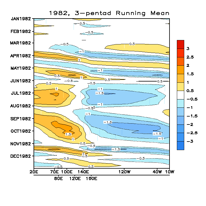
this was the same typoe of pattern what was observed in one of the more interesting El nino winters (1982/83):
1982:
1983:
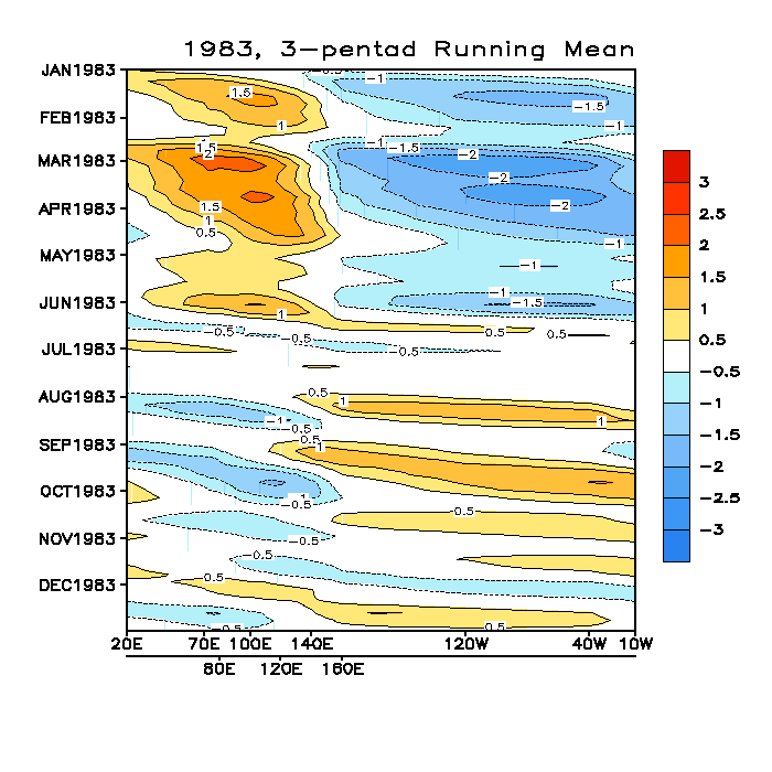
notice how the enhanced convection remained east of 120E which fed the presistently active STJ in that winter. now dont get me wrong im not trying to create analogs here. 1982/83 was a strong El Nino winter and this IS NOT. the point is that wehn the convection is further east the STJ becomes energized. much like it was that entire winter.
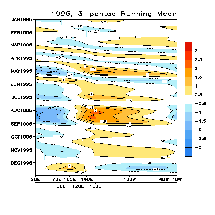
notice how the reverse is the case in the 1995/96 La Nina winter:
1995:
1996:
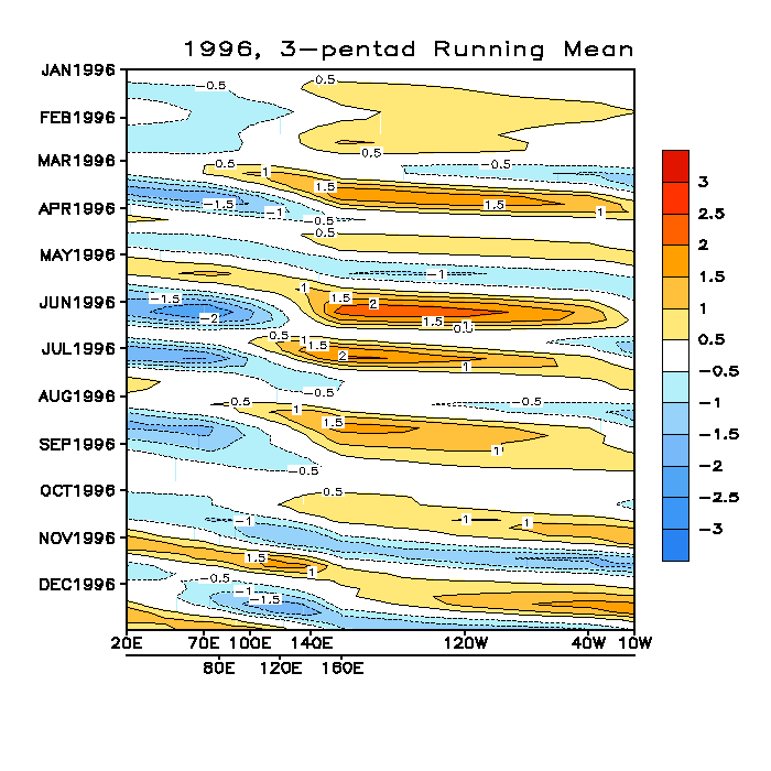
there was MUCH more variability in 1995/96...but most of all notice how enhanced convection is located near 120E with supressed convection further east. this normally correlates to a less active STJ and heavier precipitation further north along the west coast of north america.
0 likes
-
Stormsfury
- Category 5
- Posts: 10549
- Age: 53
- Joined: Wed Feb 05, 2003 6:27 pm
- Location: Summerville, SC
-
FLguy
- Professional-Met
- Posts: 799
- Joined: Mon Dec 29, 2003 5:36 pm
- Location: Daytona Beach FL
- Contact:
righyt which is in response to the cutoff of the convection near 120E.
once we see the area of current supressed convection move east and be replaced by enhanced convection near 120E the STJ will relax.
in this case i dont think the changes in the SOI will completely dictate the fluctuations in the STJ...though it may help to relax it slightly.
the current set-up across the equatorial PAC (relating to the MJO and the placement of areas of enhanced and supressed convection) which have made the cold shot possible.
if enhanced convection was located near 120E the PAC jet would still be cranking and the pattern would most likely be cold zonal.
0 likes
-
Stormsfury
- Category 5
- Posts: 10549
- Age: 53
- Joined: Wed Feb 05, 2003 6:27 pm
- Location: Summerville, SC
Just noticed that the 1024 mb high in the Mid-Atlantic (Day 7) would serve to continue to keep cold air in the Carolinas, and although, the 850mb temperatures warm across the lower South Carolina region, CAD may keep the moisture as freezing/frozen depending on the depth of the colder SFC air.
SF
SF
0 likes
-
FLguy
- Professional-Met
- Posts: 799
- Joined: Mon Dec 29, 2003 5:36 pm
- Location: Daytona Beach FL
- Contact:
Stormsfury wrote:Just noticed that the 1024 mb high in the Mid-Atlantic (Day 7) would serve to continue to keep cold air in the Carolinas, and although, the 850mb temperatures warm across the lower South Carolina region, CAD may keep the moisture as freezing/frozen depending on the depth of the colder SFC air.
SF
probably...since the models dont handle it that well...but with 850 temps above 0C and impossible to tell the depth of the cold (or below freezing) layer theres no way to tell precip type.
http://cyclone.plymouth.edu/cgi-bin/gen ... &cu=latest
but with 850 temps of only +2C across southeast SC theres a good chance that P-type would probably be FRZRA or sleet. but is really hard to say based on the low-resolution EC and the long range. were talking about 7 days out here.
0 likes
Who is online
Users browsing this forum: No registered users and 163 guests