Good evening everyone. What a frigid weekend here in the Mid Atlantic. I got my digital video cam, took video and did video reports of this arctic cold snap from central Maryland. There was this one instance yesterday on video where I noticed the effects of a boat going through thin ice. The ice was so thin on Back River in Baltimore County yesterday and the day before, only 1/2-1 inch thick. It requires 4 inches or more of ice for a person to walk in. That's the perspective I was drawing at and I mentioned temp trends also. There were and still are many water main breaks in the Baltimore area too. I wore 6 layers of clothing, 2 hoods, ear muffs, and a scarf during the heart of this cold snap while outdoors. Now Let's look at temperature trends here from Essex, MD over the past 3 days.
SATURDAY AM LOW: 7.2 degrees, -3 to -10 wind chills
SATURDAY PM HIGH: 21 degrees, -5 to 10 wind chills
SUNDAY AM LOWS: 7.2 degrees, wind calm
SUNDAY PM HIGH: 32 degrees, 14 to 21 wind chills
MONDAY AM LOW: 30 degrees
MONDAY PM HIGH: 46 degrees
Looking ahead reveals one more mild day tomorrow. By late in the afternoon Tuesday, a strong arctic cold front moves through and will produce much colder temps. Highs Tuesday near 50 here, Low Tuesday night 25, High Wednesday only 28 degrees in Baltimore. Further north into New England, Boston will likely have a high temperature of just 5 degrees on Wednesday afternoon with wind chills well below zero. This arctic snap with snow pack this time will mean business especially for New England. But the Mid Atlantic will also get nailed by this as bad if not worse than the last arctic snap given the expected snow pack we're talking about.
Speaking of snow, we still expect snow from DC north into the New York City area Wednesday night into Thursday morning as a clipper system tracks across Maryland, northern Virginia, and Delaware. Given the fast movement of this system and the expected track, accumulations will likely just be at minimal winter storm criteria, possibly on the upper end of advisory criteria. Accumulations of 3-6 inches in Philly, 3-5 inches in Baltimore, and 2-4 inches of snow in Washington DC is a possibility by Thursday morning. South of DC, snow amounts slacken quickly as the low pressure area will likely be over the DC area. It's areas along and just north of the low pressure system where the highest snow totals are expected to occur. The amounts mentioned above maybe a bit too high still as drier air and colder temps may try to win out. However any snow cover, even if it's light will enhance the extreme cold across the northeast and middle atlantic region from DC up through Boston.
More updates on this next arctic snap and the winter weather potential coming up later. At this point though, it looks like a minor winter weather/snow episode, which will likely just enhance the cold in through here. I'd be more concerned about the extreme cold than a few inches of fluffy snowfall.
Jim
winter weather, Extreme cold.
Moderator: S2k Moderators
Forum rules
 The posts in this forum are NOT official forecast and should not be used as such. They are just the opinion of the poster and may or may not be backed by sound meteorological data. They are NOT endorsed by any professional institution or STORM2K.
 The posts in this forum are NOT official forecast and should not be used as such. They are just the opinion of the poster and may or may not be backed by sound meteorological data. They are NOT endorsed by any professional institution or STORM2K.
winter weather, Extreme cold.
0 likes
- Stormsfury
- Category 5

- Posts: 10549
- Age: 53
- Joined: Wed Feb 05, 2003 6:27 pm
- Location: Summerville, SC
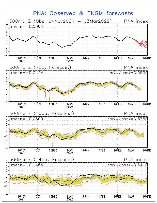
What baffles me completely is the GFS's dissipation of the extremely bitterly cold arctic air so quickly eroding after the initial burst moves in ... the 12z run then does build another very cold dome, but farther west back towards North Central Canada at the end of the period ... and looks like we're seeing a trend towards discontinuous retrogression once again. The PNA is still generally expected to remain slightly POS or Neutral ...
850mb Temperatures per GFS - loop of 240 hours

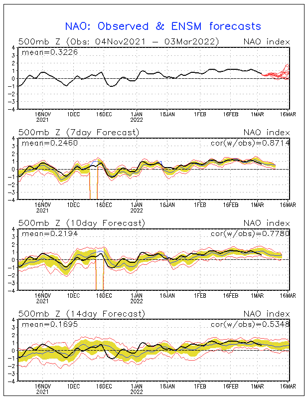
The odd thing here is that the NAO is progged to stay NEG but at the same time, the 50/50 low (phased clipper system may actually turn out SO STRONG, that when it occludes out it actually may draw warmer 850mb temperatures all the way around and loop through portions of Eastern Canada ... however, the teleconnections do support the POTENTIAL for something more than the models depict for the southern stream system ...

SF
850mb Temperatures per GFS - loop of 240 hours

The odd thing here is that the NAO is progged to stay NEG but at the same time, the 50/50 low (phased clipper system may actually turn out SO STRONG, that when it occludes out it actually may draw warmer 850mb temperatures all the way around and loop through portions of Eastern Canada ... however, the teleconnections do support the POTENTIAL for something more than the models depict for the southern stream system ...

SF
0 likes
- FLguy
- Professional-Met

- Posts: 799
- Joined: Mon Dec 29, 2003 5:36 pm
- Location: Daytona Beach FL
- Contact:
Stormsfury wrote:What baffles me completely is the GFS's dissipation of the extremely bitterly cold arctic air so quickly eroding after the initial burst moves in ... the 12z run then does build another very cold dome, but farther west back towards North Central Canada at the end of the period ... and looks like we're seeing a trend towards discontinuous retrogression once again. The PNA is still generally expected to remain slightly POS or Neutral ...
850mb Temperatures per GFS - loop of 240 hours
The odd thing here is that the NAO is progged to stay NEG but at the same time, the 50/50 low (phased clipper system may actually turn out SO STRONG, that when it occludes out it actually may draw warmer 850mb temperatures all the way around and loop through portions of Eastern Canada ... however, the teleconnections do support the POTENTIAL for something more than the models depict for the southern stream system ...
SF
its because the GFS is too fast to lift the trough out...and puts too much emphasis on a strong PJ until it becomes so stupidly obvious that the model picks up on it (usually about 3-5 days out).
0 likes
- FLguy
- Professional-Met

- Posts: 799
- Joined: Mon Dec 29, 2003 5:36 pm
- Location: Daytona Beach FL
- Contact:
and with supressed convection near 120E and enhanced convection east of the dateline (related to the MJO)...the STJ becomes energized with most of the activity shifting southward down the west coast.
http://www.cpc.ncep.noaa.gov/products/p ... index.html
http://www.cpc.ncep.noaa.gov/products/p ... index.html
0 likes
Who is online
Users browsing this forum: No registered users and 73 guests

