El Niño -- sooner or later???
Moderator: S2k Moderators
Forum rules
 The posts in this forum are NOT official forecast and should not be used as such. They are just the opinion of the poster and may or may not be backed by sound meteorological data. They are NOT endorsed by any professional institution or STORM2K.
 The posts in this forum are NOT official forecast and should not be used as such. They are just the opinion of the poster and may or may not be backed by sound meteorological data. They are NOT endorsed by any professional institution or STORM2K.
-
Derek Ortt
Currently, it is more of a la nina than el nino, though overall it is very close to neutral.
As for the models, I would only trust CLIPER. The verification stats for some of the other models are so horrific that the Iraqi intelligence services have a better track record than these particular ENSO models
As for the models, I would only trust CLIPER. The verification stats for some of the other models are so horrific that the Iraqi intelligence services have a better track record than these particular ENSO models
0 likes
- FLguy
- Professional-Met

- Posts: 799
- Joined: Mon Dec 29, 2003 5:36 pm
- Location: Daytona Beach FL
- Contact:
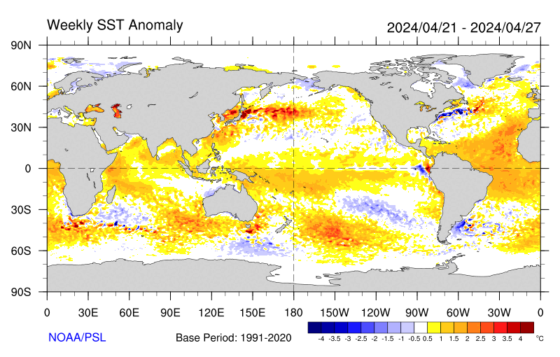
sorry...we are MUCH closer to weak El Nino conditions than ANY La Nina. Lets take a look at SSTA anomalies over the past week:

the figure above shows SSTA anomalies for the 7 day period ending december 27. Notice the that above normal SSTA continue to be in place in the NINO 4.0 region nea rthe dateline with SSTA running near to or slightly ABOVE normal across the central and eastern equatorial pacific.
the list below shows weekly SSTA means and anomalies since the beginning of OCT in textual format:
01OCT2003 20.1 -.7 25.3 .4 27.3 .6 29.1 .7
08OCT2003 20.9 .1 25.5 .6 27.4 .8 29.1 .7
15OCT2003 20.9 .0 25.2 .3 27.1 .5 29.1 .7
22OCT2003 21.5 .5 25.3 .3 27.1 .5 29.3 .9
29OCT2003 21.4 .2 25.4 .5 27.2 .6 29.3 1.0
05NOV2003 21.6 .2 25.3 .4 27.0 .5 29.4 1.0
12NOV2003 21.8 .3 25.3 .4 26.9 .4 29.3 1.0
19NOV2003 22.0 .2 25.4 .5 27.1 .5 29.3 1.0
26NOV2003 22.3 .3 25.5 .5 27.2 .7 29.2 .9
03DEC2003 22.5 .1 25.6 .6 27.1 .6 29.2 .9
10DEC2003 22.9 .3 25.5 .4 27.0 .5 29.1 .9
17DEC2003 23.0 .1 25.4 .3 26.8 .4 29.0 .7
24DEC2003 23.0 -.2 25.6 .4 26.8 .3 28.9 .6
ALL FOUR enso regions with the exception of the Nino 1+2 region the other three regions have remained solidly ABOVE normal since the beginning of OCT.
what i Will give you is the fact that SSTA in all the ENSO regions DO appear to be showing SOME signs of cooling off. If we notice the Nino 4.0 region has fallen from +1.0C above normal in NOV...to +0.6C above normal the week of the 24th.
the warmer SSTA presisting near the dateline is shown well in this weekly averaged compositew of OLR anomalies for the 7 day period ending 12/27:

Notice how well the decreased anomalous OLR corresponds well to increased convection near the dateline and WARMER SSTA in the region.
So overall the current condition in the tropical pacific can be most closely related to slightly warm ENSO neutral conditions.
Most other statistical models aside from the EMC ALSO indicate slightly warm ENSO neutral conditions continuing through the spring:
http://www.cdc.noaa.gov/seasonalfcsts/sst/lag4.html
Infact ONLY the NASA (NSIP) model supports the EMC theory in supporting the evolution toward a weak to moderate warm episode this spring.

the figure above shows SSTA anomalies for the 7 day period ending december 27. Notice the that above normal SSTA continue to be in place in the NINO 4.0 region nea rthe dateline with SSTA running near to or slightly ABOVE normal across the central and eastern equatorial pacific.
the list below shows weekly SSTA means and anomalies since the beginning of OCT in textual format:
01OCT2003 20.1 -.7 25.3 .4 27.3 .6 29.1 .7
08OCT2003 20.9 .1 25.5 .6 27.4 .8 29.1 .7
15OCT2003 20.9 .0 25.2 .3 27.1 .5 29.1 .7
22OCT2003 21.5 .5 25.3 .3 27.1 .5 29.3 .9
29OCT2003 21.4 .2 25.4 .5 27.2 .6 29.3 1.0
05NOV2003 21.6 .2 25.3 .4 27.0 .5 29.4 1.0
12NOV2003 21.8 .3 25.3 .4 26.9 .4 29.3 1.0
19NOV2003 22.0 .2 25.4 .5 27.1 .5 29.3 1.0
26NOV2003 22.3 .3 25.5 .5 27.2 .7 29.2 .9
03DEC2003 22.5 .1 25.6 .6 27.1 .6 29.2 .9
10DEC2003 22.9 .3 25.5 .4 27.0 .5 29.1 .9
17DEC2003 23.0 .1 25.4 .3 26.8 .4 29.0 .7
24DEC2003 23.0 -.2 25.6 .4 26.8 .3 28.9 .6
ALL FOUR enso regions with the exception of the Nino 1+2 region the other three regions have remained solidly ABOVE normal since the beginning of OCT.
what i Will give you is the fact that SSTA in all the ENSO regions DO appear to be showing SOME signs of cooling off. If we notice the Nino 4.0 region has fallen from +1.0C above normal in NOV...to +0.6C above normal the week of the 24th.
the warmer SSTA presisting near the dateline is shown well in this weekly averaged compositew of OLR anomalies for the 7 day period ending 12/27:

Notice how well the decreased anomalous OLR corresponds well to increased convection near the dateline and WARMER SSTA in the region.
So overall the current condition in the tropical pacific can be most closely related to slightly warm ENSO neutral conditions.
Most other statistical models aside from the EMC ALSO indicate slightly warm ENSO neutral conditions continuing through the spring:
http://www.cdc.noaa.gov/seasonalfcsts/sst/lag4.html
Infact ONLY the NASA (NSIP) model supports the EMC theory in supporting the evolution toward a weak to moderate warm episode this spring.
0 likes
- FLguy
- Professional-Met

- Posts: 799
- Joined: Mon Dec 29, 2003 5:36 pm
- Location: Daytona Beach FL
- Contact:
Derek Ortt wrote:Currently, it is more of a la nina than el nino, though overall it is very close to neutral.
As for the models, I would only trust CLIPER. The verification stats for some of the other models are so horrific that the Iraqi intelligence services have a better track record than these particular ENSO models
the pattern globally is also quite La Nina like...however much of that can be attributed to the strong east QBO over the past several months...
as the QBO continues to decline we should start seeing some major pattern changes in the next few months.
0 likes
- Stormsfury
- Category 5

- Posts: 10549
- Age: 53
- Joined: Wed Feb 05, 2003 6:27 pm
- Location: Summerville, SC
Beat me to it. I noticed this a little while ago, and might be linked to the recent very high POS burst of the SOI values, and the pattern looking La Niña-like ... in an otherwise, very much neutral to weak El Niño state.
Recent trends in the short term have seen the SOI go back negative, however, 30 day and 90 day averages are sitting at 9.54 (after peaking at 10.78), and 1.29 respectively as of Dec 31st, 2003.
SF
Recent trends in the short term have seen the SOI go back negative, however, 30 day and 90 day averages are sitting at 9.54 (after peaking at 10.78), and 1.29 respectively as of Dec 31st, 2003.
SF
0 likes
- FLguy
- Professional-Met

- Posts: 799
- Joined: Mon Dec 29, 2003 5:36 pm
- Location: Daytona Beach FL
- Contact:
Stormsfury wrote:Beat me to it. I noticed this a little while ago, and might be linked to the recent very high POS burst of the SOI values, and the pattern looking La Niña-like ... in an otherwise, very much neutral to weak El Niño state.
Recent trends in the short term have seen the SOI go back negative, however, 30 day and 90 day averages are sitting at 9.54 (after peaking at 10.78), and 1.29 respectively as of Dec 31st, 2003.
SF
the fluctuations in the SOI are probably more closely related to the SSTA set-up near the dateline than the QBO phase...but the strong PJ is most definately the product of the -QBO.
0 likes
- Stormsfury
- Category 5

- Posts: 10549
- Age: 53
- Joined: Wed Feb 05, 2003 6:27 pm
- Location: Summerville, SC
- Stormsfury
- Category 5

- Posts: 10549
- Age: 53
- Joined: Wed Feb 05, 2003 6:27 pm
- Location: Summerville, SC
Check this out ... that is a BONAFIDE KW (Kelvin Wave) and this will have INTERESTING consequences regarding the Jan 12-14th timeframe and ALSO MAY induce the development of the progged El Niño for 2004 ...

1) throw in the mix the arctic air NOW currently infiltrating the US.
2) Increasing PAC storminess
Along with the MJO which is heading east (dry phase) ...
This image also CLEARLY shows the KW ..

More information about the MJO and Kelvin Waves can be found on my website located on this [url=http://www.stormsfury1.com/Weather/Info.html]PAGE...
The Kelvin wave COULD have reprecussions on what could finally be an El Niño taking shape in a couple of months or so ...
SF

Kelvin Wave - Near a boundary in a rotating system, a Kelvin wave propagates with wave crests perpendicular to the side wall and wave height greatest at the side wall to the right of an observer looking in the direction of wave propagation. The wave height decreases exponentially from the side wall with e-folding length scale equal to the Rossby deformation radius c/f, in which f is the Coriolis parameter and c is the phase speed of the wave in the along boundary direction. In the shallow water approximation the waves are non-dispersive with frequency \omega = +/- c k, in which k is the along boundary wavenumber and the phase speed c = (gH)^(1/2) with g the acceleration of gravity and H the mean fluid depth. Related to Kelvin waves in a channel are Poincare' waves.
1) throw in the mix the arctic air NOW currently infiltrating the US.
2) Increasing PAC storminess
Along with the MJO which is heading east (dry phase) ...
This image also CLEARLY shows the KW ..

More information about the MJO and Kelvin Waves can be found on my website located on this [url=http://www.stormsfury1.com/Weather/Info.html]PAGE...
The Kelvin wave COULD have reprecussions on what could finally be an El Niño taking shape in a couple of months or so ...
SF
0 likes
Who is online
Users browsing this forum: No registered users and 128 guests


