What does that mean for mid/late JAN here in the CONUS?
Anyone care to elaborate?
-JEB
We have a positive Madden-Julian oscillation coming on...
Moderator: S2k Moderators
Forum rules
 The posts in this forum are NOT official forecast and should not be used as such. They are just the opinion of the poster and may or may not be backed by sound meteorological data. They are NOT endorsed by any professional institution or STORM2K.

The posts in this forum are NOT official forecast and should not be used as such. They are just the opinion of the poster and may or may not be backed by sound meteorological data. They are NOT endorsed by any professional institution or STORM2K.
-
FLguy

- Professional-Met

- Posts: 799
- Joined: Mon Dec 29, 2003 5:36 pm
- Location: Daytona Beach FL
- Contact:
The MJO or Madden-Julian Oscillation is described by the eastward progression of areas of enhanced and suppressed tropical rainfall evident over the equatorial regions however is best observed across the Indian and pacific oceans. The areas of enhanced and suppressed convection associated with the MJO are first seen over the Indian and pacific oceans then continue eastward across the equatorial pacific...losing to a degree their notability until re-emerging over the Atlantic and Indian oceans.
The MJO cycles last 30-60 days (on average) and can effect everything from the Pacific jet (important in winter) to Atlantic and pacific TC activity during the hurricane season and tropical weather in general. The MJO as first researched in 1971 by Roland Madden and Paul Julian (thus its name). While the two were researching zonal wind anomalies over the tropical pacific. However it was not actively studied by the meteorological community until the 1980s. Before that...some researchers even dismissed its significance.
MJO activity is especially dependent on the observed phase of the ENSO. ENSO neutral and La Nina conditions tend to favor a HIGHLY active MJO; whereas on the other hand El Nino events correlate to suppressed MJO activity. (One of the reasons why the pacific jet displays MUCH more variability in La Nina and ENSO neutral winters than El Nino winters).
the Madden-Julian oscillation (as previously eluted to) effects the entire tropical troposphere however is most clear over the western pacific and Indian Oceans (west of the dateline or 180 degrees longitude). The MJO considers changes in changes in winds...SST anomalies...cloudiness and convection over the regions above. The MJO is observed most easily observed by considering the changes in Outgoing long wave radiation (OLR) over the equatorial regions. This is b/c the anvil tops of convection over the equatorial regions give off less outgoing long-wave radiation (they are colder).
Therefore Areas of enhanced convection would be characterized by less OLR and areas of decreased or suppressed convection would be consistent with more OLR.
Equatorially trapped (or Kelvin and Rossby waves) which are used in predicting the evolution toward warm ENSO conditions are also the primary driving force behind the MJO. Theese waves are found in the troposphere between about 30N and 30S...located Primarily in the EASTERN hemisphere.
Here/s a 3-dimensional look at the MJO from Wang and Rui (1990):
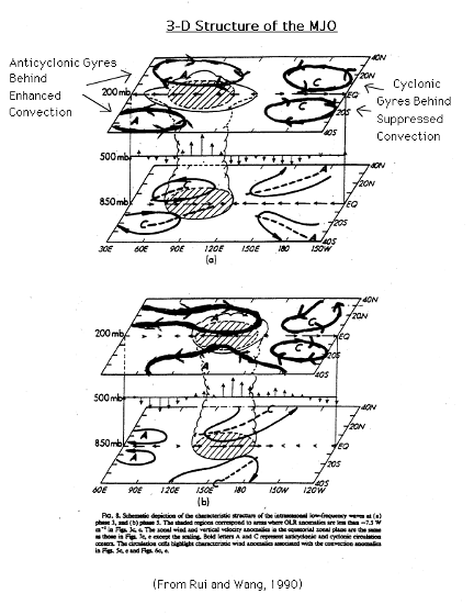
Air at the SFC flows away from the suppressed convection in both zonal directions toward the areas of enhanced convection...while in the upper layers anomalous easterly winds exit from the western side of the enhanced convection and flow toward the suppressed convection.
If suppressed convection is observed from the Indian Ocean to the central pacific...the development of cyclonic gyres are observed at 200 hPa following the suppressed convection (when strong). In a similar way... anti-cyclonic gyres follow the areas of enhanced convection as the convection strengthens. The gyres at the surface are much weaker than those in the troposphere (at 200mb).
There as many ways we can monitor the behavior of the MJO. Most analysis methods are displayed in a time-longitude format to show the movement and amplitude and location of waves as they come east. Typical time-longitude sections use OLR anomalies (derived from satellite information to show areas of tropical convection) velocity potential…which isolates the divergent component of the wind in the upper levels. And finally… low and upper level wind anomalies.
The MJO can have significant impacts on the circulations over the north pacific and portions of western North America during the cold season (winter)…in addition to blocking patterns.
On the tropical side (attention SF…tropicalweatherwatcher and others)…the MJO related descending motions (and subsidence) over the tropical Atlantic can minimize the potential for tropical development…whereas ascending motions over the North Atlantic related to the MJO can promote TC development.
There is also a VERY strong link between a very active MJO and the potential for significant precipitation events in the western part of the country.
The figure below illustrates some aspects of the connection between the pacific jet…MJO and significant precipitation events in the western part of the country:
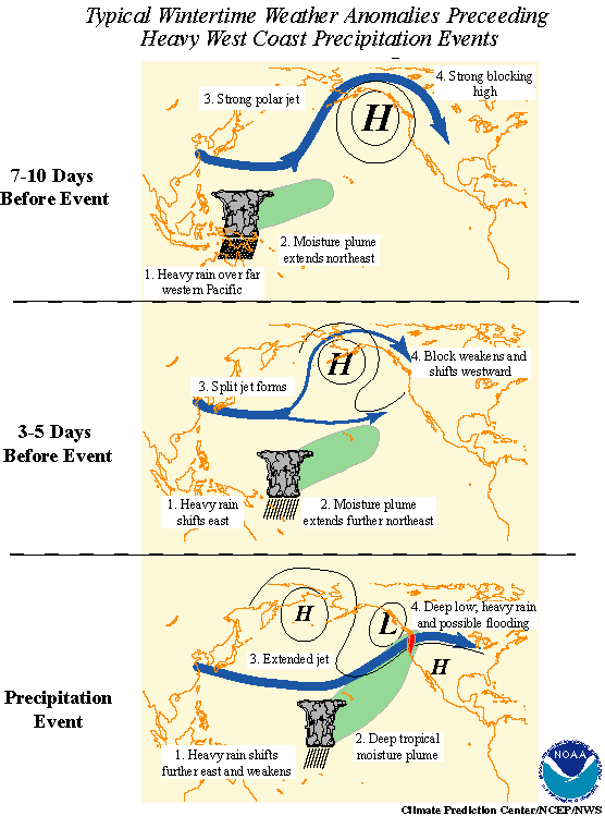
It should also be noted that NOT all aspects of the MJO/s effect on the wintertime Pacific jet are known. It will take many more years of research to fully understand these details.
The MJO cycles last 30-60 days (on average) and can effect everything from the Pacific jet (important in winter) to Atlantic and pacific TC activity during the hurricane season and tropical weather in general. The MJO as first researched in 1971 by Roland Madden and Paul Julian (thus its name). While the two were researching zonal wind anomalies over the tropical pacific. However it was not actively studied by the meteorological community until the 1980s. Before that...some researchers even dismissed its significance.
MJO activity is especially dependent on the observed phase of the ENSO. ENSO neutral and La Nina conditions tend to favor a HIGHLY active MJO; whereas on the other hand El Nino events correlate to suppressed MJO activity. (One of the reasons why the pacific jet displays MUCH more variability in La Nina and ENSO neutral winters than El Nino winters).
the Madden-Julian oscillation (as previously eluted to) effects the entire tropical troposphere however is most clear over the western pacific and Indian Oceans (west of the dateline or 180 degrees longitude). The MJO considers changes in changes in winds...SST anomalies...cloudiness and convection over the regions above. The MJO is observed most easily observed by considering the changes in Outgoing long wave radiation (OLR) over the equatorial regions. This is b/c the anvil tops of convection over the equatorial regions give off less outgoing long-wave radiation (they are colder).
Therefore Areas of enhanced convection would be characterized by less OLR and areas of decreased or suppressed convection would be consistent with more OLR.
Equatorially trapped (or Kelvin and Rossby waves) which are used in predicting the evolution toward warm ENSO conditions are also the primary driving force behind the MJO. Theese waves are found in the troposphere between about 30N and 30S...located Primarily in the EASTERN hemisphere.
Here/s a 3-dimensional look at the MJO from Wang and Rui (1990):
Air at the SFC flows away from the suppressed convection in both zonal directions toward the areas of enhanced convection...while in the upper layers anomalous easterly winds exit from the western side of the enhanced convection and flow toward the suppressed convection.
If suppressed convection is observed from the Indian Ocean to the central pacific...the development of cyclonic gyres are observed at 200 hPa following the suppressed convection (when strong). In a similar way... anti-cyclonic gyres follow the areas of enhanced convection as the convection strengthens. The gyres at the surface are much weaker than those in the troposphere (at 200mb).
There as many ways we can monitor the behavior of the MJO. Most analysis methods are displayed in a time-longitude format to show the movement and amplitude and location of waves as they come east. Typical time-longitude sections use OLR anomalies (derived from satellite information to show areas of tropical convection) velocity potential…which isolates the divergent component of the wind in the upper levels. And finally… low and upper level wind anomalies.
The MJO can have significant impacts on the circulations over the north pacific and portions of western North America during the cold season (winter)…in addition to blocking patterns.
On the tropical side (attention SF…tropicalweatherwatcher and others)…the MJO related descending motions (and subsidence) over the tropical Atlantic can minimize the potential for tropical development…whereas ascending motions over the North Atlantic related to the MJO can promote TC development.
There is also a VERY strong link between a very active MJO and the potential for significant precipitation events in the western part of the country.
The figure below illustrates some aspects of the connection between the pacific jet…MJO and significant precipitation events in the western part of the country:
It should also be noted that NOT all aspects of the MJO/s effect on the wintertime Pacific jet are known. It will take many more years of research to fully understand these details.
Last edited by FLguy on Fri Jan 02, 2004 12:55 am, edited 1 time in total.
0 likes
-
FLguy
- Professional-Met
- Posts: 799
- Joined: Mon Dec 29, 2003 5:36 pm
- Location: Daytona Beach FL
- Contact:
Jeb --- an active MJO and very strong pacific jet can make it harder for significant pattern amplification to occur thus reducing the potential for a major arctic intrusion into the EUS.
instead it can lead to more of a cold zonal pattern. in which most of the cold air is hung up across the northern part of the country waiting for amplification to bring it south.
instead it can lead to more of a cold zonal pattern. in which most of the cold air is hung up across the northern part of the country waiting for amplification to bring it south.
0 likes
-
Stormsfury

- Category 5

- Posts: 10549
- Age: 53
- Joined: Wed Feb 05, 2003 6:27 pm
- Location: Summerville, SC
And which on OUR side of the hemisphere, currently, the MJO is NEG (wet phase) but WEST of the DATELINE, a very dry phase (POS MJO) will continue to head east, and LOOK THE ---- OUT!!! (Which seems to coincide with DT's (excellent) discussion earlier tonight about the POSSIBILITY of a SECS/MECS in the 12th-14th timeframe ...
SF
SF
0 likes
-
Anonymous
FLguy wrote:Jeb --- an active MJO and very strong pacific jet can make it harder for significant pattern amplification to occur thus reducing the potential for a major arctic intrusion into the EUS.
instead it can lead to more of a cold zonal pattern. in which most of the cold air is hung up across the northern part of the country waiting for amplification to bring it south.
Hello?....
FLguy stated "an active MJO and very strong pacific jet can make it harder for significant pattern amplification to occur thus reducing the potential for a major arctic intrusion into the EUS".
We have a strong Pac Jet, DT's Pac Jet lol, that will inhibit the arctic air from coming south.
We have relatively mild air in place in the MA/MW SNE region.
We have the SE Ridge to consider. That puppy tends to hasten solid-to-liquid phase changes with respect to precip.
AND we have the Madden-Julian Oscillation thrown in for good measure.
lol......
Which seems to coincide with DT's (excellent) discussion earlier tonight about the POSSIBILITY of a SECS/MECS in the 12th-14th timeframe ...
This is 12:02am Jan 2 2004, approximately ten to twelve days out. We're talking about 240hrs PLUS off of a Model projection.
Face up to the mild winter in the EUS, excepting the northern tier which will see some arctic air bleed southward over time.
I need to get a life; all of us need to get a life.
A snowstorm is not the only thing in life. It's not going to happen anyway. You have to consider the Pac Jet, the SE Ridge, AND the MJO plus the reality of the mild air in place and a model projection 240 hours in the future and ALL the variables which have to fall into place just so.
JEB
AND we are talking about a model projection
0 likes
-
FLguy
- Professional-Met
- Posts: 799
- Joined: Mon Dec 29, 2003 5:36 pm
- Location: Daytona Beach FL
- Contact:
Stormsfury wrote:And which on OUR side of the hemisphere, currently, the MJO is NEG (wet phase) but WEST of the DATELINE, a very dry phase (POS MJO) will continue to head east, and LOOK THE ---- OUT!!! (Which seems to coincide with DT's (excellent) discussion earlier tonight about the POSSIBILITY of a SECS/MECS in the 12th-14th timeframe ...
SF
YES EXACTLY...
The wet (-MJO) phase is strongly correlated to an enhanced pacific jet...as much as the dry/positive phase is to a weaker pacific jet. Once the wave gets east of the dateline it should begin to shut off the PAC jet.
I should have also noted that the MJO displays a coupled kelvin and rossby wave structure in the eastern hemisphere however in the western hemisphere the kelvin wave structure is the most prevalent.
Also the horizontal gyres and zonal circulations are functions by which the MJO is able to shift around mass in the tropics.
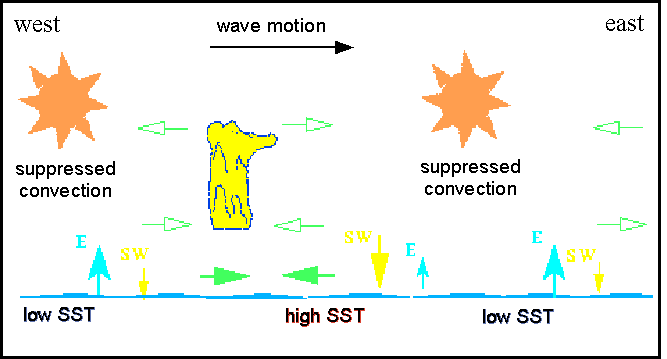
here is another representation on how the waves propogate across the Equatorial regions:
0 likes
-
Stormsfury
- Category 5
- Posts: 10549
- Age: 53
- Joined: Wed Feb 05, 2003 6:27 pm
- Location: Summerville, SC
-
Anonymous
Stormsfury wrote:Jeb, re-read the post. We are getting ready to head into an INACTIVE phase (DRY PERIOD) of the MJO ... after being in an active phase for quite a while now ...
EDIT: Just saw FLguy's post. Thanks, dude.
SF
240 hour model projections aside, IF the inactive phase of the MJO verifies and the Pac Jet weakens, it stands to reason that the arctic air might have a chance-----------I said it has a chance---------of maybe coming south into the CONUS.
However folks, we have in the past gotten WAY too overexcited about this crap.
Caution is called for here. Let's see if the MJO does go inactive------and then lets see if the Pac Jet weakens, and then we'll observe the arctic airmass in Canada.
Can the PNA go POS? Can the NAO tank?
This is NO time to get overly excited, look at all the different variables that have yet to fall into place.
JEB
0 likes
-
FLguy
- Professional-Met
- Posts: 799
- Joined: Mon Dec 29, 2003 5:36 pm
- Location: Daytona Beach FL
- Contact:
Jeb wrote:Stormsfury wrote:Jeb, re-read the post. We are getting ready to head into an INACTIVE phase (DRY PERIOD) of the MJO ... after being in an active phase for quite a while now ...
EDIT: Just saw FLguy's post. Thanks, dude.
SF
240 hour model projections aside, IF the inactive phase of the MJO verifies and the Pac Jet weakens, it stands to reason that the arctic air might have a chance-----------I said it has a chance---------of maybe coming south into the CONUS.
However folks, we have in the past gotten WAY too overexcited about this crap.
Caution is called for here. Let's see if the MJO does go inactive------and then lets see if the Pac Jet weakens, and then we'll observe the arctic airmass in Canada.
Can the PNA go POS? Can the NAO tank?
This is NO time to get overly excited, look at all the different variables that have yet to fall into place.
JEB
*** IF *** the weakening of the PAC jet (courtesy of the MJO) coincides with the development of both a -NAO and +PNA...that cold air WILL come down and deliver a MAJOR arctic outbreak to the central and eastern part of the country.
a +PNA and -NAO alone is a STRONG cold signal for the eastern US...add in a weaker PAC jet and one has the potential or a severe arctic intrusion IF sufficient cold air is around. any energy undercutting the western ridge would have to be watched.
Last edited by FLguy on Fri Jan 02, 2004 12:40 am, edited 1 time in total.
0 likes
-
Stormsfury
- Category 5
- Posts: 10549
- Age: 53
- Joined: Wed Feb 05, 2003 6:27 pm
- Location: Summerville, SC
No worries about the COLD being sufficient ... it's there in Canada and spreading ... Greenland, Canada, and Alaska ... it's all there (or soon will be enough) and CLEARLY NOT 2001-2002 all over again...
I haven't changed my discussion on my website from 2 nights ago, 'cuz I still stand by it ... maybe tomorrow night I will to reflect the MJO phase expected to go POS ..
Go back here for some indicy maps for the MJO to see what I'm talking about, Jeb.
http://www.storm2k.org/phpbb2/viewtopic.php?t=22106
0 likes
-
Anonymous
Need to keep an eye on the Quasi-Biennial Oscillation values as well, if they are low then we could indeed be looking at the potential for major EC storms.
Very interesting.
Will keep an eye on this.
BTW.......IF the cold comes down, then someone needs to start cooking Crow lol, cuz I said NO cold air in the CONUS lol. Add some Tabasco sauce lol......
-Jeb
Very interesting.
Will keep an eye on this.
BTW.......IF the cold comes down, then someone needs to start cooking Crow lol, cuz I said NO cold air in the CONUS lol. Add some Tabasco sauce lol......
-Jeb
0 likes
-
FLguy
- Professional-Met
- Posts: 799
- Joined: Mon Dec 29, 2003 5:36 pm
- Location: Daytona Beach FL
- Contact:
Jeb wrote:Need to keep an eye on the Quasi-Biennial Oscillation values as well, if they are low then we could indeed be looking at the potential for major EC storms.
Very interesting.
Will keep an eye on this.
BTW.......IF the cold comes down, then someone needs to start cooking Crow lol, cuz I said NO cold air in the CONUS lol. Add some Tabasco sauce lol......
-Jeb
yes i agree...
QBO values between +10 and -10 (near neutral values) tend to correlate well with the increased probability of a major east coast snow event.
Also one may be able to look for the weakening of PJ (which has been VERY dominant of late).
0 likes
-
FLguy
- Professional-Met
- Posts: 799
- Joined: Mon Dec 29, 2003 5:36 pm
- Location: Daytona Beach FL
- Contact:
FLguy wrote:Jeb wrote:Need to keep an eye on the Quasi-Biennial Oscillation values as well, if they are low then we could indeed be looking at the potential for major EC storms.
Very interesting.
Will keep an eye on this.
BTW.......IF the cold comes down, then someone needs to start cooking Crow lol, cuz I said NO cold air in the CONUS lol. Add some Tabasco sauce lol......
-Jeb
yes i agree...
QBO values between +10 and -10 (near neutral values) tend to correlate well with the increased probability of a major east coast snow event.
Also one may be able to look for the weakening of PJ (which has been VERY dominant of late).
and dont worry i will have a nice hot bowl of crow supreme cooked up for you in the S2k bar as soon as you bust.
0 likes
-
Anonymous
-
Anonymous
-
Anonymous
-
Anonymous
-
FLguy
- Professional-Met
- Posts: 799
- Joined: Mon Dec 29, 2003 5:36 pm
- Location: Daytona Beach FL
- Contact:
Jeb wrote:K folks I'll be back later; its 1258am here in Virginia.
I don't need to go to met school, I can just stay at this board.
I can see I got some apologies to make.........................and I can see I have a LOT to learn about weather LOL LOL LOL LOL LOL.
Jeb
becuase in 2001/02 the QBO values WERE favorable...however due to various other factors...it didin/t mean poop. as those other factors overshadowed it.
last winter QBO values were also similar and because the large scale pattern favored major east coast snowstorms...we saw such events (Xmas blizzard...Presidents day).
the tool only works when the overall pattern is consistent with the development of major east coast snowstorms. if other factors DO NOT favor a major event...there WILL NOT be one. (ie...2001/02).
IMO the correlation is there...however it is a weaker...secondary correlation. the primary driving feature behind a major east coast snow event is the large scale pattern.
0 likes
Who is online
Users browsing this forum: No registered users and 93 guests