#6 Postby Stormsfury » Tue Dec 30, 2003 6:33 pm
I beg to differ. This is from the Preliminary Report written in January 1999 by John Guiney.
Georges (pronounced Zhorzh) was the second deadliest and second strongest hurricane within the Atlantic basin during the 1998 season. Its 17 day journey resulted in seven landfalls, extending from the northeastern Caribbean to the coast of Mississippi, and 602 fatalities -- mainly in the Dominican Republic and Haiti.
a. Synoptic History
Georges originated from a tropical wave, observed by satellite and upper-air data, which crossed the west coast of Africa late on 13 September. Rawinsonde data from Dakar, Senegal showed an attendant 35 to 45 knot easterly jet between 550 and 650 millibars (mb). On the 14th, visible satellite imagery depicted a large, well-defined cloud system in association with the wave and meteorologists at the Tropical Prediction Center/National Hurricane Center (NHC) Tropical Analysis and Forecast Branch (TAFB), the Satellite Analysis Branch (SAB) of the National Environmental Satellite, Data, and Information Service, and the Air Force Weather Agency (AFGWC) began satellite-based Dvorak intensity classifications. By early on the 15th, ship reports indicated the presence of a closed surface circulation in this system and it is estimated that a tropical depression formed at 1200 UTC, centered about 300 n mi south-southwest of the Cape Verde Islands in the far eastern Atlantic, as shown in the post-storm "best-track" - see Table 1 and Figure 1 (39K GIF). During the next 24 hours the tropical depression continued to become better organized as banding features developed and deep convection formed over the center. The system became a tropical storm at 1200 UTC on 16 September while centered about 620 n mi west-southwest of the Cape Verde Islands. Georges moved on a persistent west-northwest course for the next ten days, a classic Cape Verde-type track, in response to a mid- to upper-level tropospheric ridge which strengthened with height.
Georges continued to gradually strengthen over the next several days, reaching hurricane intensity around 1800 UTC on 17 September when a banding-type eye feature became evident in satellite imagery. By the 19th, an upper-level anticyclone was well-established over Georges and satellite pictures suggested that the hurricane was beginning to strengthen rapidly, as indicated by the cooling cloud tops, increased symmetry of the deep convection, and the warming and contracting of the well-defined eye.
By early afternoon on the 19th, the first U.S. Air Force Reserve (USAFR) reconnaissance aircraft reached the hurricane and measured maximum flight-level winds of 146 knots and a minimum central pressure of 938 mb - confirming the intensification trend noted in satellite imagery. Georges' winds were increased to 125 knots at 1800 UTC on the 19th making it a category four hurricane on the Saffir-Simpson Hurricane Scale.
Several Global Positioning System (GPS) dropwinsondes were deployed within the eye-wall region of the hurricane during these reconnaissance missions. Near-surface (below 200 feet) wind estimates from these drops indicate maximum winds from 134 knots to 150 knots. On this basis, Georges is estimated to have reached a peak intensity of 135 knots at 0600 UTC on the 20th while located about 285 n mi east of Guadeloupe in the Lesser Antilles. Although GPS Dropwinsondes data is still being evaluated by scientists at the National Oceanic and Atmospheric Administration (NOAA) Hurricane Research Division, preliminary research suggests that the observed near-surface winds approximate one-minute values. For additional information on the GPS Dropwindsondes, please see Franklin (1997) and Franklin et. al. (1997).
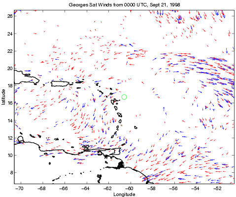
Shortly after 0600 UTC 20 September, the hurricane began a marked weakening trend with the eye becoming indiscernible in satellite pictures, or to aerial reconnaissance by that afternoon. Examination of water vapor satellite imagery and satellite-derived wind analyses from the Cooperative Institute for Meteorological Satellite Studies at the University of Wisconsin suggest that one possible factor responsible for the weakening could have been upper-level northerly vertical wind shear induced by an upper-level anticyclone located over the eastern Caribbean. By the evening of the 20th, the central pressure had risen 26 mb and Georges weakened. It then made the first two of its seven landfalls in the Lesser Antilles, first in Antigua then in St. Kitts and Nevis, early on the 21st with maximum sustained surface winds of 100 knots.
By mid-morning of the 21st an upper-level low over Cuba, denoted in water vapor imagery, was moving westward away from Georges thereby reducing the possibility of Georges moving to the northwest, away from Puerto Rico. Later in the afternoon, the shear appeared to diminish and the outflow aloft improved but Georges never fully recovered due in part to the circulation's interaction with Puerto Rico. Georges made landfall in southeast Puerto Rico with sustained surface winds of 100 knots on the evening of the 21st. The hurricane moved inland over Puerto Rico and weakened slightly and then moved into the Mona Passage early on the 22nd. Georges began to re-intensify while over the Mona Passage and made landfall later that morning in the Dominican Republic, about 75 n mi east of Santo Domingo with estimated sustained surface winds of 105 knots.
During the next 21 hours Georges weakened as it moved slowly across the mountainous terrain of the Dominican Republic and Haiti, where it produced copious rains resulting in deadly flash floods and mud slides. The system emerged into the Windward Passage on the morning of the 23rd with 65 knot maximum winds. Georges changed little before making landfall in eastern Cuba later that afternoon, about 25 n mi east of Guantanamo Bay. The system retained hurricane status while moving slowly west-northwestward across the northern coast of Cuba, exiting the northern coast by late afternoon on the 24th. Satellite imagery showed that the system retained a fairly impressive upper-level outflow pattern during its crossing of both Hispaniola and Cuba.
Once back over water, the hurricane began to re-intensify. Satellite pictures showed that a band of deep convection developed east of the center early on the 25th which expanded throughout the morning. Georges made landfall during mid-morning of the 25th in Key West, Florida with a minimum central pressure of 981 mb and maximum winds of 90 knots. After moving away from Key West, Georges turned more to the northwest, then north-northwest, and gradually slowed down on the 26th and 27th. This occurred in response to the mid-tropospheric anticyclone north of the hurricane shifting eastward into the southeastern United States. The hurricane made landfall near Biloxi, Mississippi on the morning of the 28th with estimated maximum sustained one-minute winds of 90 knots and a minimum central pressure of 964 mb. After landfall, the system meandered around southern Mississippi and was downgraded to a tropical storm on the afternoon of the 28th.
Georges became quasi-stationary for the next 6 to 12 hours moving in a cyclonic loop over southern Mississippi. The tropical storm began moving in a generally northeast to east direction early on the 29th and was downgraded to a tropical depression by mid-morning while located about 30 n mi north-northeast of Mobile, Alabama. Georges continued to move eastward at 5 to 10 knots on the 29th and 30th. By early morning of 1 October, the system dissipated near the northeast Florida/southeast Georgia coast, although a very weak remnant low did emerge over the western Atlantic during the day. However, the remnant circulation merged with a frontal zone by late on the 1st.
SF
0 likes