Another Severe Weather Outbreak coming?
Moderator: S2k Moderators
Forum rules

The posts in this forum are NOT official forecast and should not be used as such. They are just the opinion of the poster and may or may not be backed by sound meteorological data. They are NOT endorsed by any professional institution or STORM2K.
-
PTrackerLA

- Category 5

- Posts: 5281
- Age: 42
- Joined: Thu Oct 10, 2002 8:40 pm
- Location: Lafayette, LA
Another Severe Weather Outbreak coming?
I've been hearing talk on the news of a nasty severe weather event possible for tuesday. Freezing temps this weekend then severe weather...it's a constant roller coaster!
0 likes
-
weatherlover427
-
Stormsfury

- Category 5
- Posts: 10549
- Age: 53
- Joined: Wed Feb 05, 2003 6:27 pm
- Location: Summerville, SC
Joshua21Young wrote:The seasons are a-changin' that's for sure! :o Where might this potential outbreak happen? :-?
http://www.stormsfury1.com
Use the navigation toolbar on the homepage to go to "My Forecast/prognostic discussion" ... I don't go into great detail regarding the ARKLATEX region, but yes, according to the ECMWF, SE TX, LA, MS do stand a chance of seeing a severe weather outbreak next week ... I'll try to keep everyone updated nightly until go time ...
SF
0 likes
-
southerngale

- Retired Staff

- Posts: 27418
- Joined: Thu Oct 10, 2002 1:27 am
- Location: Southeast Texas (Beaumont area)

 my Cowboys
 -
ColdFront77
-
Suzi Q
SE Texas threat
Well I heard about a severe outbreak this morning for Tuesday from Channel 2. Lucky me, I have no finals on Tuesday so if it happens, my happy self will be out driving around. We might need to keep an eye on this one fellow GOMERS. 
0 likes
-
Guest
-
wx247

- S2K Supporter

- Posts: 14279
- Age: 42
- Joined: Wed Feb 05, 2003 10:35 pm
- Location: Monett, Missouri
- Contact:
With this track their definitely looks to be some storms, especially from Texarkana down towards Houston.
0 likes
Personal Forecast Disclaimer:
The posts in this forum are NOT official forecast and should not be used as such. They are just the opinion of the poster and may or may not be backed by sound meteorological data. They are NOT endorsed by any professional institution or storm2k.org. For official information, please refer to the NHC and NWS products.
The posts in this forum are NOT official forecast and should not be used as such. They are just the opinion of the poster and may or may not be backed by sound meteorological data. They are NOT endorsed by any professional institution or storm2k.org. For official information, please refer to the NHC and NWS products.
-
PTrackerLA
- Category 5
- Posts: 5281
- Age: 42
- Joined: Thu Oct 10, 2002 8:40 pm
- Location: Lafayette, LA
-
ColdFront77
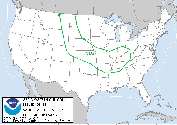
SPC AC 071107
DAY 3 CONVECTIVE OUTLOOK
NWS STORM PREDICTION CENTER NORMAN OK
0507 AM CST SUN DEC 07 2003
VALID 091200Z - 101200Z
...THERE IS A SLGT RISK OF SVR TSTMS OVER PARTS OF E TX/LA AND THE
CNTRL GULF CST....
...SYNOPSIS...
AN ACTIVE...AMPLIFIED AND PROGRESSIVE PATTERN EXPECTED ACROSS THE
LWR 48 ON TUESDAY. SHORTWAVE TROUGH NOW APPROACHING THE WA/ORE
CST...LIKELY TO BE OVER SW TX EARLY IN THE PERIOD...SHOULD CONTINUE
E TO THE LWR MS VLY BY LATE TUESDAY AND ASSUME A NEGATIVE TILT. AT
THE SAME TIME...EQUALLY POTENT UPSTREAM DISTURBANCE... NOW FORMING
WELL S OF THE ALEUTIANS...EXPECTED TO REACH NRN CA BY 12Z WEDNESDAY.
SURFACE LOW THAT WILL ACCOMPANY TX TROUGH SHOULD BE OVER CNTRL OK AT
THE START OF THE PERIOD. THE SYSTEM WILL LIKELY DEEPEN AND ARC NE
INTO WRN KY/SRN IND BY 12Z WEDNESDAY. IN THE WEST...COLD FRONT
ASSOCIATED WITH PACIFIC LOW SHOULD MOVE INTO CNTRL CA LATE IN THE
PERIOD.
LATEST ENSEMBLE DATA SUGGEST THAT MODELS ARE MORE OR LESS CONVERGING
ON THE STRONGER/SLOWER SOLUTION WITH THE TX TROUGH AS WAS ORIGINALLY
FORECAST BY THE ECMWF. IN CONTRAST...CONSIDERABLE UNCERTAINTY
REMAINS WITH SYSTEM APPROACHING THE W CST.
...E TX/WRN LA TO CNTRL GULF CST...
A FEW CLUSTERS/BANDS OF THUNDERSTORMS MAY BE PRESENT AT THE START OF
THE PERIOD IN WARM ADVECTION ZONE EXTENDING NNEWD FROM E TX INTO ERN
OK/WRN AR. MOST OF THIS ACTIVITY WILL PROBABLY BE SLIGHTLY ELEVATED.
WEAK INSTABILITY SHOULD LIMIT SEVERE THREAT... ALTHOUGH MARGINALLY
SEVERE HAIL COULD ACCOMPANY SOME OF THE STORMS.
COMBINATION OF MODEST SURFACE HEATING AND...MORE IMPORTANTLY...
INCREASING LARGE SCALE ASCENT...SHOULD RESULT IN INTENSIFICATION/
INCREASED ORGANIZATION OF THE STORMS AS UPPER IMPULSE APPROACHES
REGION BY MIDDAY. GIVEN 60+ KT MID LEVEL SW FLOW ROUNDING BASE OF
TROUGH AND 30+ KT SLY LOW LEVEL JET...AMPLE SHEAR WILL BE PRESENT TO
SUPPORT SUPERCELLS. BUT SUCH ACTIVITY SHOULD REMAIN EMBEDDED WITHIN
LINES/CLUSTERS GIVEN LINEAR NATURE OF MESOSCALE FORCING AND BACKING
FLOW ALOFT. IN ADDITION...PRECIPITATION INTO WEAKLY-RECOVERED
BOUNDARY LAYER ENVIRONMENT WILL LIKELY RETARD NWD RETURN OF TRUE
GULF AIR INTO LA. THIS SHOULD LIMIT OVERALL DEGREE/EXTENT OF SEVERE
THREAT. NEVERTHELESS...BOWING SEGMENTS WITH HIGH WIND/HAIL AND
PERHAPS A COUPLE TORNADOES COULD OCCUR WHEREVER SUSTAINED
SURFACE-BASED STORMS DO FORM.
LATER IN THE PERIOD...A LIMITED THREAT WILL EXIST FOR
REINTENSIFICATION OF EMBEDDED CONVECTIVE BAND NEWD INTO THE LWR TN
VLY AS UPPER SYSTEM BECOMES MORE NEGATIVELY-TILTED AND STRONG
FRONTOGENETIC FORCING ENCOUNTERS INCREASING MOISTURE INFLOW. WHILE
WIND FIELD WILL BE STRONG...LIMITED INSTABILITY EXPECTED TO PRECLUDE
A THREAT FOR WIDESPREAD SEVERE. ISOLATED SEVERE ACTIVITY
MAY...HOWEVER...AFFECT COASTAL SECTIONS OF MS/AL AND FL DURING THIS
TIME.
..CORFIDI.. 12/07/2003
...NOTICE...
FOR USERS DECODING THE POINTS PARAGRAPH HEREIN...LATITUDE AND
LONGITUDE POINTS FOR THE CATEGORICAL AND PROBABILISTIC OUTLOOK
GRAPHICS ALSO ARE LOCATED IN A SEPARATE PRODUCT UNDER THE WMO
HEADINGS WUUS01 PTSDY1...WUUS02 PTSDY2...AND WUUS03 PTSDY3. THE
INCLUSION OF POINTS IN THIS PRODUCT WILL EVENTUALLY BE DISCONTINUED.
NOTE: THE NEXT DAY 3 OUTLOOK IS SCHEDULED FOR 1200Z
CURRENT UTC TIME: 2330Z, RELOAD THIS PAGE TO UPDATE THE TIME.
This may prove more interesting with the initial possibility of some severe weather at the very least.
0 likes
-
PTrackerLA
- Category 5
- Posts: 5281
- Age: 42
- Joined: Thu Oct 10, 2002 8:40 pm
- Location: Lafayette, LA
-
ColdFront77
-
PTrackerLA
- Category 5
- Posts: 5281
- Age: 42
- Joined: Thu Oct 10, 2002 8:40 pm
- Location: Lafayette, LA
Looks like just a line of T-storms now with no big severe weather threat. After that it's back to near freezing temps with highs in the 50's and then another storm for the weekend. I've also been reading indications of an arctic outbreak before Christmas, hopefully moisture and arctic air can combine to give us some wintry precip.
0 likes
Return to “USA & Caribbean Weather”
Who is online
Users browsing this forum: No registered users and 54 guests