That was one of the craziest storms I've ever seen approaching DFW last night. Fortunately it weakened before the major population centers but yikes
I also tried numerous times to login last night and it never worked either
Tornado watch again today here but it's looking like we get a pretty solid cold front next week. Way below normal temps showing up
Texas Spring 2026
Moderator: S2k Moderators
Forum rules

The posts in this forum are NOT official forecast and should not be used as such. They are just the opinion of the poster and may or may not be backed by sound meteorological data. They are NOT endorsed by any professional institution or STORM2K.
-
Brent
- S2K Supporter

- Posts: 38787
- Age: 37
- Joined: Sun May 16, 2004 10:30 pm
- Location: Tulsa Oklahoma
- Contact:
Re: Texas Spring 2026
Last edited by Brent on Sun Apr 26, 2026 5:26 pm, edited 2 times in total.
0 likes
#neversummer
-
wxman22

- Category 5

- Posts: 2053
- Joined: Mon Jan 30, 2006 12:39 am
- Location: Wichita Falls, TX
- Contact:
Re: Texas Spring 2026
Here we go again.
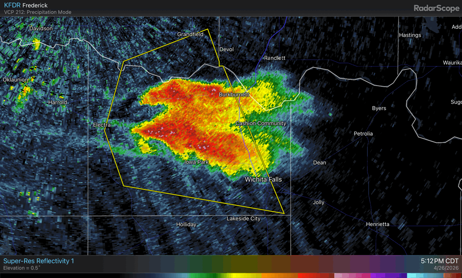
BULLETIN - IMMEDIATE BROADCAST REQUESTED
Severe Thunderstorm Warning
National Weather Service Norman OK
524 PM CDT Sun Apr 26 2026
The National Weather Service in Norman has issued a
* Severe Thunderstorm Warning for...
South central Comanche County in southwestern Oklahoma...
Cotton County in southwestern Oklahoma...
Southeastern Tillman County in southwestern Oklahoma...
Northeastern Wichita County in northern Texas...
* Until 615 PM CDT.
* At 524 PM CDT, a severe thunderstorm was located near Devol, moving
northeast at 30 mph.
HAZARD...Ping pong ball size hail and 60 mph wind gusts.
SOURCE...Radar indicated.
IMPACT...People and animals outdoors will be injured. Expect hail
damage to roofs, siding, windows, and vehicles. Expect
wind damage to roofs, siding, and trees.
* Locations impacted include...
Burkburnett, Walters, Geronimo, Grandfield, Randlett, Devol, Faxon,
and Cookietown.
0 likes
-
wxman22
- Category 5
- Posts: 2053
- Joined: Mon Jan 30, 2006 12:39 am
- Location: Wichita Falls, TX
- Contact:
Re: Texas Spring 2026
Tornado warning issued. Tornado sirens on right now in WF.
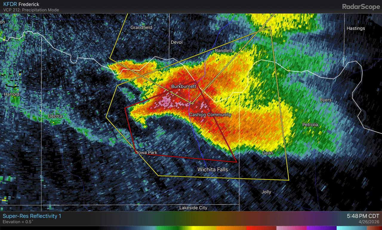

BULLETIN - EAS ACTIVATION REQUESTED
Tornado Warning
National Weather Service Norman OK
547 PM CDT Sun Apr 26 2026
The National Weather Service in Norman has issued a
* Tornado Warning for...
East central Wichita County in northern Texas...
* Until 630 PM CDT.
* At 547 PM CDT, a severe thunderstorm capable of producing a tornado
was located near Iowa Park, moving east at 15 mph.
HAZARD...Tornado and golf ball size hail.
SOURCE...Radar indicated rotation.
IMPACT...Flying debris will be dangerous to those caught without
shelter. Mobile homes will be damaged or destroyed.
Damage to roofs, windows, and vehicles will occur. Tree
damage is likely.
* Locations impacted include...
Northern Wichita Falls, Burkburnett, Iowa Park, Sheppard AFB,
Pleasant Valley, and Cashion.
0 likes
-
txtwister78

- Category 5
- Posts: 2257
- Joined: Wed Jan 30, 2019 12:56 pm
- Location: San Antonio
Re: Texas Spring 2026
Going to miss WF thankfully. North of town. Look out southern Oklahoma.
Classic flying V/flying eagle shaped supercell. Intense updraft. Could be another strong Tornado somewhere along the river into Oklahoma.
Classic flying V/flying eagle shaped supercell. Intense updraft. Could be another strong Tornado somewhere along the river into Oklahoma.
0 likes
-
cheezyWXguy

- Category 5
- Posts: 6284
- Joined: Mon Feb 13, 2006 12:29 am
- Location: Dallas, TX


Re: Texas Spring 2026
No severe weather for me. Just the way I like it. Was a little worried there for a bit last night.
0 likes
-
wxman22
- Category 5
- Posts: 2053
- Joined: Mon Jan 30, 2006 12:39 am
- Location: Wichita Falls, TX
- Contact:
Re: Texas Spring 2026
Multiple reports and pics of baseball size hail in northern Wichita county from that supercell. The storm produced a nice wall cloud also. But thankfully no tornado has been confirmed so far.One of the local chief mets has been following the storm live on air in the storm tracker vehicle for over an hour now.The open fields, lower amount of trees, and prairies here really allow for some very photogenic pics of storms.

0 likes
-
Stratton23
- Category 5
- Posts: 3589
- Joined: Fri Jul 21, 2023 10:59 pm
- Location: Katy, Tx
Re: Texas Spring 2026
Looks like the Cap will win out this time, that supercell has weakened considerably
0 likes
-
txtwister78
- Category 5
- Posts: 2257
- Joined: Wed Jan 30, 2019 12:56 pm
- Location: San Antonio
Re: Texas Spring 2026
Stratton23 wrote:Looks like the Cap will win out this time, that supercell has weakened considerably
Yeah it will and once again highlighting my overall point from earlier (widespread severe weather across northern Oklahoma and into Kansas/Missouri) BUT that will change for folks further south into TX this week as we get some big lift/trigger help courtesy of another strong frontal boundary.
Euro really setting the stage for an active week ahead potentially across Central/SC TX points east. More beneficial rainfall on the way with the possibility of some severe weather mixed in.
0 likes
-
wxman22
- Category 5
- Posts: 2053
- Joined: Mon Jan 30, 2006 12:39 am
- Location: Wichita Falls, TX
- Contact:
Re: Texas Spring 2026
txtwister78 wrote:wxman22 wrote:txtwister78 wrote:
The cap breaking further north isn't unusual given that region has had better lift to work with either from ejecting disturbances from the SW/frontal boundaries or leftover boundaries interacting with the dryline from previous day storms.
Across N TX outside of last evening the cap has held however but overall it's been the Oklahoma points N/NE regions when it comes to severe weather but as I mentioned given the setup not that surprising.
Next wk could be more active again further south into Texas as a front charges in.
Nah, not just yesterday.Theirs been several conditional days this month that the cap has broken along the dryline in NW Texas specifically. I'm not just referring to the current severe weather sequence. I would know I've been keeping count and i live up here. April reports below. Not all of those reports in Texas come from conditional days but many do.
https://www.spc.noaa.gov/climo/summary/2026/ruf/NAT/NAT_APR_ALL.png
Actually yeah and trust me brother I know you keep track as documented by your multiple play by play post up there. I get where you live etc (you highlighted it above just in case we missed it) so no worries but that doesn't change the discussion or facts that I outlined respectfully either in my response.
Just an FYI you can have caps in place daily in the spring/summer (not unusual for the south) but the ability for storms to fire and thus breach that cap is highly dependent on factors like lifting mechanisms as I described above so again I stand by my statement in that further north that really hasn't been much of a surprise or high hurdle to meet thus far this season in that there has been more lift available up there to work with. So again I don't think that's been up for much debate as you indicated.
When I said "N TX" I was talking DFW generally speaking. It wasn't meant as a slight to Wichita or "NW TX" which I didn't mention. I don't view severe weather as a contest of who gets more or less trust me my friend in that regar but your graphic proves my point.
I'm confused what the debate or disagreement is here. I only mentioned that the cap has broken several times on conditional days here this month as it did also again today. And that some mets were saying before the start of the season that the drought across the Southwest could cause capping issues this season in the Plains.I was just saying that it appears the drought has not been a big factor when it comes to the cap this season as some thought it could be.I didn't say that was my opinion on the situation. Don't shoot the messenger. I never said anything about it being unusual or surprising at all either.
And the only reason why those sections were highlighted was because there were other state reports mixed in so i was just highlighting the Texas reports. And also usually when big severe weather is happening I post reports,watches and radar across the state regardless of the location.I don't just focus on my area. You can see that clearly in my post history.Everything doesn't need to be a debate.
If severe weather is occurring im gonna talk about it i don't care how you feel. As you seem to have a problem with it. You can ignore my post if you don't like them.We can agree to disagree.
0 likes
-
Iceresistance

- Category 5
- Posts: 9610
- Age: 22
- Joined: Sat Oct 10, 2020 9:45 am
- Location: Tecumseh, OK/Norman, OK
Re: Texas Spring 2026
I just can't with this weather, the storms always find a way to miss me
I'm going to be in a nasty drought if this doesn't stop, why is this happening? Is Central Oklahoma really that cursed for storms?
I'm going to be in a nasty drought if this doesn't stop, why is this happening? Is Central Oklahoma really that cursed for storms?
0 likes
Bill 2015 & Beta 2020
Winter 2020-2021
All observations are in Tecumseh, OK unless otherwise noted.
Winter posts are focused mainly for Oklahoma & Texas.
Take any of my forecasts with a grain of salt, refer to the NWS, SPC, and NHC for official information
Never say Never with weather! Because ANYTHING is possible!
Winter 2020-2021
All observations are in Tecumseh, OK unless otherwise noted.
Winter posts are focused mainly for Oklahoma & Texas.
Take any of my forecasts with a grain of salt, refer to the NWS, SPC, and NHC for official information
Never say Never with weather! Because ANYTHING is possible!
-
txtwister78
- Category 5
- Posts: 2257
- Joined: Wed Jan 30, 2019 12:56 pm
- Location: San Antonio
Re: Texas Spring 2026
wxman22 wrote:txtwister78 wrote:wxman22 wrote:
Nah, not just yesterday.Theirs been several conditional days this month that the cap has broken along the dryline in NW Texas specifically. I'm not just referring to the current severe weather sequence. I would know I've been keeping count and i live up here. April reports below. Not all of those reports in Texas come from conditional days but many do.
https://www.spc.noaa.gov/climo/summary/2026/ruf/NAT/NAT_APR_ALL.png
Actually yeah and trust me brother I know you keep track as documented by your multiple play by play post up there. I get where you live etc (you highlighted it above just in case we missed it) so no worries but that doesn't change the discussion or facts that I outlined respectfully either in my response.
Just an FYI you can have caps in place daily in the spring/summer (not unusual for the south) but the ability for storms to fire and thus breach that cap is highly dependent on factors like lifting mechanisms as I described above so again I stand by my statement in that further north that really hasn't been much of a surprise or high hurdle to meet thus far this season in that there has been more lift available up there to work with. So again I don't think that's been up for much debate as you indicated.
When I said "N TX" I was talking DFW generally speaking. It wasn't meant as a slight to Wichita or "NW TX" which I didn't mention. I don't view severe weather as a contest of who gets more or less trust me my friend in that regar but your graphic proves my point.
I'm confused what the debate or disagreement is here. I only mentioned that the cap has broken several times on conditional days here this month as it did also again today. And that some mets were saying before the start of the season that the drought across the Southwest could cause capping issues this season in the Plains.I was just saying that it appears the drought has not been a big factor when it comes to the cap this season as some thought it could be.I didn't say that was my opinion on the situation. Don't shoot the messenger. I never said anything about it being unusual or surprising at all either.
And the only reason why those sections were highlighted was because there were other state reports mixed in so i was just highlighting the Texas reports. And also usually when big severe weather is happening I post reports,watches and radar across the state regardless of the location.I don't just focus on my area. You can see that clearly in my post history.Everything doesn't need to be a debate.
If severe weather is occurring im gonna talk about it i don't care how you feel. As you seem to have a problem with it. You can ignore my post if you don't like them.We can agree to disagree.
Simply an observation in response to a post you made about the "cap debate further north" being a factor I thought was of interest in light of all the severe weather. Nothing more?
FYI...Capping inversions in general have nothing to do with droughts directly as they routinely occur pretty frequently during the spring/summer season whether it be under drought conditions or not. With a clear signal/transition to El Nino having been seen by all mets coming since February, the likelihood of a more active Spring (even in a neutral state) somewhere across the southern plains was a pretty good bet as was being discussed on here in early March by me and others so if a debate were to have occured it wouldn't have been about whether we would have had days where the cap would "win out" across Texas (happens all the time lol) but how much of the drought overall we could actually erase.
Finally and respectfully, and again to be clear you're the one that brings "your location" into it my friend and twist my comments into something of a personal slight toward your region when I mentioned N TX as having largely escaped for the most part as a result of a stronger cap influence/lack of lifting mechanism other than last night's storms (in the context of all the severe weather throughout this season thus far just north of that area) which again you decided to make that about "your area"? Ok great. Only problem is I wasn't talking about or narrowly focused on Wichita Falls when I made that comment? Lol
For the record I don't care what you post on here (let those frame by frame radar returns and daily storm reports rip... have at it) but I'll remind you this is the second time you've mischaractrrized my post and made that into something of a personal attack about "your area" as if it's some WF contest (obviously not) or personal slight when it hasn't been that at all??? You apologized the first time which I appreciated but here we are again? Don't assume would be my advice to you. Always happy to clarify my post/comments anytime if you can't figure those out initially. Moving on. Apologies to forum.
0 likes
-
Brent
- S2K Supporter
- Posts: 38787
- Age: 37
- Joined: Sun May 16, 2004 10:30 pm
- Location: Tulsa Oklahoma
- Contact:
Re: Texas Spring 2026
Iceresistance wrote:I just can't with this weather, the storms always find a way to miss me
I'm going to be in a nasty drought if this doesn't stop, why is this happening? Is Central Oklahoma really that cursed for storms?
Yeah I dunno it's so weird to me I mean we've had more severe weather since March than I remember here and yet all these people on Facebook in my heavily based OKC pages are like nothing has happened an hour down the interstate basically. We had 2 inches the other night from what was left of Enid. But I'm ready to just clear out or something and get a different pattern. Tired of the hype tired of all the annoying people online who can't read a map or live in a constant state of panic for some reason(no idea how they've lived here their whole life)... Just tired. Everyone couldn't wait for spring all what little winter we had and now I'm like well here y'all go hope y'all are happy

Not gonna lie I'm kind of excited about the possibility of 60 degrees and cloudy a couple days this coming week... Need to enjoy it while it lasts
0 likes
#neversummer
Return to “USA & Caribbean Weather”
Who is online
Users browsing this forum: No registered users and 10 guests