WPAC: SINLAKU - Typhoon
Moderators: S2k Moderators, WesternPacificWeatherMods
Forum rules

The posts in this forum are NOT official forecast and should not be used as such. They are just the opinion of the poster and may or may not be backed by sound meteorological data. They are NOT endorsed by any professional institution or STORM2K.

Re: WPAC: SINLAKU - Typhoon
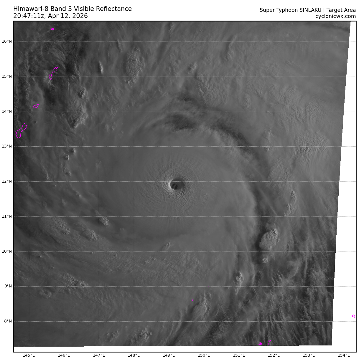
JMA 18z went with a DT 8.0 but they chose PT as CI which is 7.5
1 likes
ヤンデレ女が寝取られるているのを見たい!!!
ECMWF ensemble NWPAC plots: https://ecmwfensnwpac.imgbb.com/
Multimodel NWPAC plots: https://multimodelnwpac.imgbb.com/
GFS Ensemble NWPAC plots (16 & 35 day forecast): https://gefsnwpac.imgbb.com/
Plots updated automatically
ECMWF ensemble NWPAC plots: https://ecmwfensnwpac.imgbb.com/
Multimodel NWPAC plots: https://multimodelnwpac.imgbb.com/
GFS Ensemble NWPAC plots (16 & 35 day forecast): https://gefsnwpac.imgbb.com/
Plots updated automatically

Re: WPAC: SINLAKU - Typhoon
Models are all showing a close pass or landfall within the next 48 hours.
0 likes
-
Hurricane2022

- Category 5

- Posts: 2083
- Joined: Tue Aug 23, 2022 11:38 pm
- Location: Araçatuba, Brazil
Re: WPAC: SINLAKU - Typhoon
TPPN10 PGTW 121758
A. SUPER TYPHOON 04W (SINLAKU)
B. 12/1730Z
C. 11.49N
D. 149.52E
E. ONE/GK2A
F. T7.5/7.5/D2.5/24HRS STT: S0.0/03HRS
G. IR/EIR
H. REMARKS: 01A/PBO EYE/ANMTN. WMG EYE SURROUNDED BY CMG YIELDS AN
E# OF 6.5. ADDED 1.0 EYE ADJUSTMENT FOR CMG, TO YIELD A DT OF 7.5.
MET YIELDS 6.5. PT YIELDS 7.0. DBO DT.
I. ADDITIONAL POSITIONS: NONE
LINDGREN
0 likes
Sorry for the bad English sometimes...!
For reliable and detailed information for any meteorological phenomenon, please consult the National Hurricane Center, Joint Typhoon Warning Center , or your local Meteo Center.
--------
ECCE OMNIA NOVA FACIAM (Ap 21,5).
For reliable and detailed information for any meteorological phenomenon, please consult the National Hurricane Center, Joint Typhoon Warning Center , or your local Meteo Center.
--------
ECCE OMNIA NOVA FACIAM (Ap 21,5).
Re: WPAC: SINLAKU - Typhoon
04W SINLAKU 260412 1800 11.7N 149.5E WPAC 155 896
3 likes
ヤンデレ女が寝取られるているのを見たい!!!
ECMWF ensemble NWPAC plots: https://ecmwfensnwpac.imgbb.com/
Multimodel NWPAC plots: https://multimodelnwpac.imgbb.com/
GFS Ensemble NWPAC plots (16 & 35 day forecast): https://gefsnwpac.imgbb.com/
Plots updated automatically
ECMWF ensemble NWPAC plots: https://ecmwfensnwpac.imgbb.com/
Multimodel NWPAC plots: https://multimodelnwpac.imgbb.com/
GFS Ensemble NWPAC plots (16 & 35 day forecast): https://gefsnwpac.imgbb.com/
Plots updated automatically
-
Hurricane2022
- Category 5
- Posts: 2083
- Joined: Tue Aug 23, 2022 11:38 pm
- Location: Araçatuba, Brazil
Re: WPAC: SINLAKU - Typhoon
0 likes
Sorry for the bad English sometimes...!
For reliable and detailed information for any meteorological phenomenon, please consult the National Hurricane Center, Joint Typhoon Warning Center , or your local Meteo Center.
--------
ECCE OMNIA NOVA FACIAM (Ap 21,5).
For reliable and detailed information for any meteorological phenomenon, please consult the National Hurricane Center, Joint Typhoon Warning Center , or your local Meteo Center.
--------
ECCE OMNIA NOVA FACIAM (Ap 21,5).
Re: WPAC: SINLAKU - Typhoon
The strongest since Ragasa
WTPQ50 RJTD 121800
RSMC TROPICAL CYCLONE ADVISORY
NAME TY 2604 SINLAKU (2604)
ANALYSIS
PSTN 121800UTC 11.6N 149.5E GOOD
MOVE NW 09KT
PRES 905HPA
MXWD 115KT
GUST 165KT
50KT 90NM
30KT 325NM NORTHEAST 270NM SOUTHWEST
FORECAST
24HF 131800UTC 13.9N 146.5E 35NM 70%
MOVE NW 09KT
PRES 905HPA
MXWD 115KT
GUST 165KT
48HF 141800UTC 15.6N 144.9E 55NM 70%
MOVE NW 06KT
PRES 915HPA
MXWD 105KT
GUST 150KT
72HF 151800UTC 17.6N 143.8E 80NM 70%
MOVE NNW 06KT
PRES 925HPA
MXWD 095KT
GUST 135KT
96HF 161800UTC 20.3N 143.9E 100NM 70%
MOVE N 07KT
PRES 945HPA
MXWD 085KT
GUST 120KT
120HF 171800UTC 22.9N 145.2E 150NM 70%
MOVE NNE 07KT
PRES 965HPA
MXWD 070KT
GUST 100KT =
0 likes
ヤンデレ女が寝取られるているのを見たい!!!
ECMWF ensemble NWPAC plots: https://ecmwfensnwpac.imgbb.com/
Multimodel NWPAC plots: https://multimodelnwpac.imgbb.com/
GFS Ensemble NWPAC plots (16 & 35 day forecast): https://gefsnwpac.imgbb.com/
Plots updated automatically
ECMWF ensemble NWPAC plots: https://ecmwfensnwpac.imgbb.com/
Multimodel NWPAC plots: https://multimodelnwpac.imgbb.com/
GFS Ensemble NWPAC plots (16 & 35 day forecast): https://gefsnwpac.imgbb.com/
Plots updated automatically
Re: WPAC: SINLAKU - 18z Best Track is below 900 mbs

0 likes
ヤンデレ女が寝取られるているのを見たい!!!
ECMWF ensemble NWPAC plots: https://ecmwfensnwpac.imgbb.com/
Multimodel NWPAC plots: https://multimodelnwpac.imgbb.com/
GFS Ensemble NWPAC plots (16 & 35 day forecast): https://gefsnwpac.imgbb.com/
Plots updated automatically
ECMWF ensemble NWPAC plots: https://ecmwfensnwpac.imgbb.com/
Multimodel NWPAC plots: https://multimodelnwpac.imgbb.com/
GFS Ensemble NWPAC plots (16 & 35 day forecast): https://gefsnwpac.imgbb.com/
Plots updated automatically
-
MarioProtVI
- Category 5
- Posts: 1038
- Age: 24
- Joined: Sun Sep 29, 2019 7:33 pm
- Location: New Jersey
Re: WPAC: SINLAKU - Typhoon
MarioProtVI wrote:This is basically Mawar and Bolaven from three years ago wrapped into one. Would not rule out it actually getting that strong officially - can see a 155-160 kt peak here if all goes well, which it has been doing so far.
Nailed it
3 likes


Re: WPAC: SINLAKU - Typhoon
I maintain that Sinlaku's peak started around 6 hours ago, and was around 165 kt and at or below 886 hPa. My rationale for the wind speed estimate is that that's where subjective and objective DT/ADT estimates were at the time (and indeed, still are, despite the fact that weakening appears to have started). ADT and subjective DT were 8.0, notwithstanding the apparent prohibition on assigning subjective T-values over 7.5 at the JTWC. SATCON and D-PRINT were also closer to 160 kt than 155 kt between 09z and 15z; AIDT and D-MINT were also at 152 kt and 155 kt, respectively, by 12z - and these represented the floor of the data envelope. ADT CI had exceeded 7.5 by 11z; ADT Adj. got there 3 hours earlier, around the same time that EIR satellite imagery began to support subjective DT 8.0.
As for my MSLP estimate, even using the most conservative available values for 34kt wind radii by quadrant (<180 nm avg.) and forward motion (10+ kt), the CKZ wind-pressure relationship gives a ΔP of -122.3 for a 165 kt storm between 10.5~11°N. Assuming MSLP at the outermost closed isobar was 1008 hPa, that comes out to 885.7 hPa for Sinlaku's central pressure. It's worth noting that the JTWC's official gale radii are larger than the values I used here; if we were to use the JTWC's own gale radii and P(Env) values, CKZ would yield 882.2 hPa.
As for my MSLP estimate, even using the most conservative available values for 34kt wind radii by quadrant (<180 nm avg.) and forward motion (10+ kt), the CKZ wind-pressure relationship gives a ΔP of -122.3 for a 165 kt storm between 10.5~11°N. Assuming MSLP at the outermost closed isobar was 1008 hPa, that comes out to 885.7 hPa for Sinlaku's central pressure. It's worth noting that the JTWC's official gale radii are larger than the values I used here; if we were to use the JTWC's own gale radii and P(Env) values, CKZ would yield 882.2 hPa.
The posts in this forum are NOT official forecasts and should not be used as such. They are just the opinion of the poster and may or may not be backed by sound meteorological data. They are NOT endorsed by any professional institution or STORM2K. For official information, please refer to products from the NHC and NWS.
3 likes
-
Category5Kaiju

- Category 5
- Posts: 4345
- Joined: Thu Dec 24, 2020 12:45 pm
- Location: Seattle during the summer, Phoenix during the winter
Re: WPAC: SINLAKU - Typhoon
Looks like Saipan and Tinian are in for a beating 
I'm getting Mawar and Yutu vibes from this beast.
I'm getting Mawar and Yutu vibes from this beast.
4 likes
Unless explicitly stated, all information in my posts is based on my own opinions and observations. Tropical storms and hurricanes can be extremely dangerous. Refer to an accredited weather research agency or meteorologist if you need to make serious decisions regarding an approaching storm.
-
Yellow Evan

- Professional-Met

- Posts: 16255
- Age: 27
- Joined: Fri Jul 15, 2011 12:48 pm
- Location: Henderson, Nevada/Honolulu, HI
- Contact:
Re: WPAC: SINLAKU - Typhoon
sasha_B wrote:I maintain that Sinlaku's peak started around 6 hours ago, and was around 165 kt and at or below 886 hPa. My rationale for the wind speed estimate is that that's where subjective and objective DT/ADT estimates were at the time (and indeed, still are, despite the fact that weakening appears to have started). ADT and subjective DT were 8.0, notwithstanding the apparent prohibition on assigning subjective T-values over 7.5 at the JTWC. SATCON and D-PRINT were also closer to 160 kt than 155 kt between 09z and 15z; AIDT and D-MINT were also at 152 kt and 155 kt, respectively, by 12z - and these represented the floor of the data envelope. ADT CI had exceeded 7.5 by 11z; ADT Adj. got there 3 hours earlier, around the same time that EIR satellite imagery began to support subjective DT 8.0.
As for my MSLP estimate, even using the most conservative available values for 34kt wind radii by quadrant (<180 nm avg.) and forward motion (10+ kt), the CKZ wind-pressure relationship gives a ΔP of -122.3 for a 165 kt storm between 10.5~11°N. Assuming MSLP at the outermost closed isobar was 1008 hPa, that comes out to 885.7 hPa for Sinlaku's central pressure. It's worth noting that the JTWC's official gale radii are larger than the values I used here; if we were to use the JTWC's own gale radii and P(Env) values, CKZ would yield 882.2 hPa.The posts in this forum are NOT official forecasts and should not be used as such. They are just the opinion of the poster and may or may not be backed by sound meteorological data. They are NOT endorsed by any professional institution or STORM2K. For official information, please refer to products from the NHC and NWS.
886 mbar is tough here based on evolution. Most storms that either have recon or other obs of that got below ~890 either was a pinhole or had an initial peak followed by a smooth ERC (Tip, Meranti). Sinlaku did neither. 160/892 may be slightly better and still within margin of error for Dvorak and objective aids.
1 likes
-
mrbagyo

- Category 5
- Posts: 3982
- Age: 33
- Joined: Thu Apr 12, 2012 9:18 am
- Location: 14.13N 120.98E
- Contact:
Re: WPAC: SINLAKU - Typhoon


1 likes
The posts in this forum are NOT official forecast and should not be used as such. They are just the opinion of the poster and may or may not be backed by sound meteorological data. They are NOT endorsed by any professional institution or storm2k.org. For official information, please refer to RSMC, NHC and NWS products.
Return to “Active Storms - WestPAC/Asia”
Who is online
Users browsing this forum: Google [Bot] and 57 guests