https://x.com/TrevorTropicsWX/status/2042059217410900349
SPAC: MAILA - Post-Tropical
Moderators: hurricanetrack, S2k Moderators
Forum rules

The posts in this forum are NOT official forecast and should not be used as such. They are just the opinion of the poster and may or may not be backed by sound meteorological data. They are NOT endorsed by any professional institution or STORM2K.
-
cycloneye

- Admin

- Posts: 149666
- Age: 69
- Joined: Thu Oct 10, 2002 10:54 am
- Location: San Juan, Puerto Rico
Re: SPAC: MAILA - Severe Tropical Cyclone
0 likes
Visit the Caribbean-Central America Weather Thread where you can find at first post web cams,radars
and observations from Caribbean basin members Click Here
and observations from Caribbean basin members Click Here


Re: SPAC: MAILA - Severe Tropical Cyclone
0 likes
TC naming lists: retirements and intensity
Most aggressive Advisory #1's in North Atlantic (cr. kevin for starting the list)
Most aggressive Advisory #1's in North Atlantic (cr. kevin for starting the list)
-
cycloneye
- Admin
- Posts: 149666
- Age: 69
- Joined: Thu Oct 10, 2002 10:54 am
- Location: San Juan, Puerto Rico
Re: SPAC: MAILA - Severe Tropical Cyclone

0 likes
Visit the Caribbean-Central America Weather Thread where you can find at first post web cams,radars
and observations from Caribbean basin members Click Here
and observations from Caribbean basin members Click Here


Re: SPAC: MAILA - Severe Tropical Cyclone
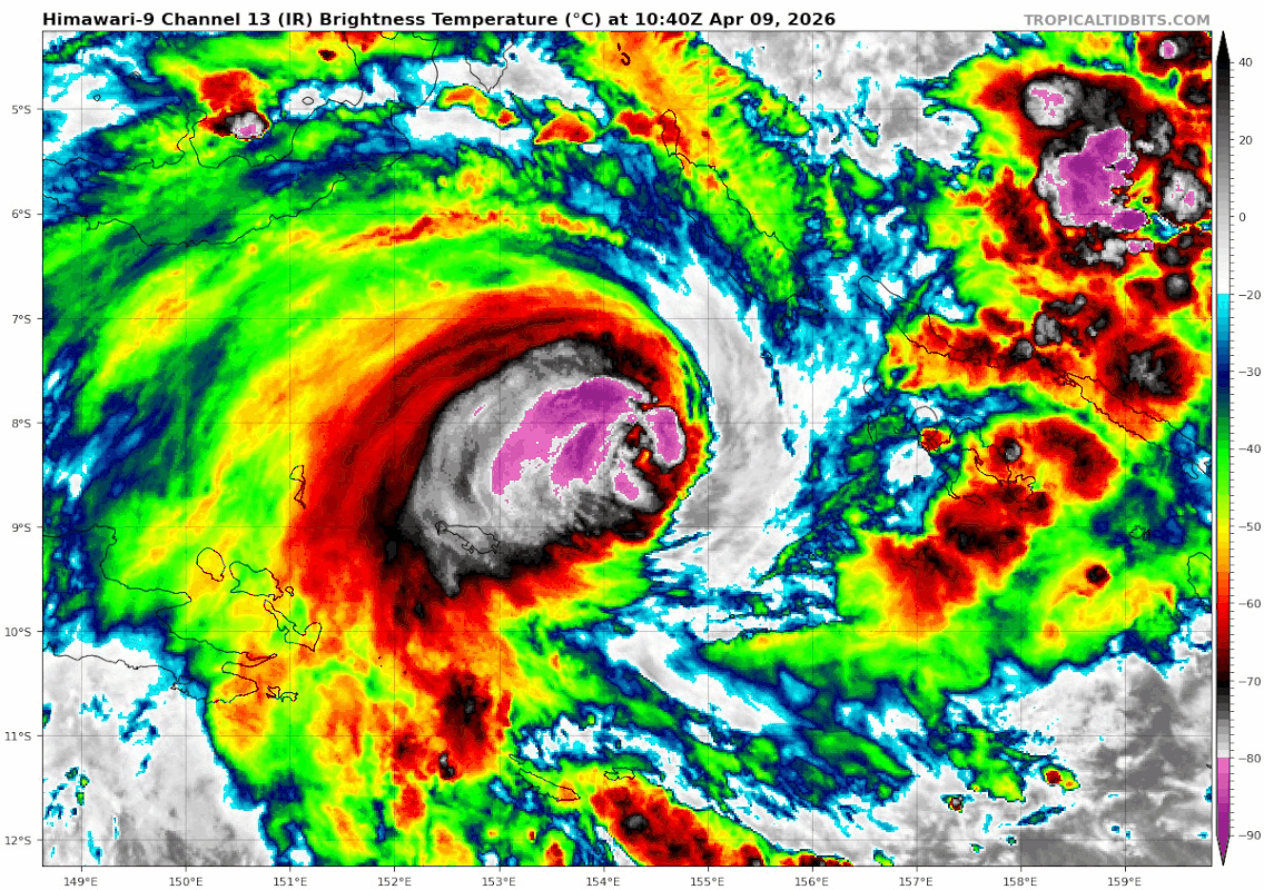
I think Cyclone Maila peaked around 130 kt (1-minute sustained) and 924 hPa, circa 1200 UTC yesterday, based on a consistent subjective presentation of T6.5 and ADT CI resting a little higher at T6.6 (with raw fixes of T6.3~7.0) at that time. That is to say, I think Aus. BoM was spot-on with 130 kt (based on 115ⅹ1.14) and 924 hPa, and the JTWC was a little low with 125 kt and 930 hPa. This would put Maila at an intensity comparable to Dudzai's, but still weaker than Horacio and Narelle in my record-keeping.
However, based on WMO standards, it is officially the most intense storm of the year so far, having matched both of those storms for wind speed at a lower central pressure per the responsible RSMCs' operational tracks.
However, based on WMO standards, it is officially the most intense storm of the year so far, having matched both of those storms for wind speed at a lower central pressure per the responsible RSMCs' operational tracks.
2 likes
-
cycloneye
- Admin
- Posts: 149666
- Age: 69
- Joined: Thu Oct 10, 2002 10:54 am
- Location: San Juan, Puerto Rico
Re: SPAC: MAILA - Post-Tropical
Last warning:
LOCATED APPROXIMATELY 534
NM SOUTH OF KAPINGAMARANGI, HAS TRACKED NORTHEASTWARD AT 06 KNOTS
OVER THE PAST SIX HOURS. ANIMATED MULTISPECTRAL IMAGERY (MSI)
REVEALS THAT TC 30P HAS NEARLY COMPLETELY UNRAVELED OVER THE PAST
12 HOURS, BECOMING A SHALLOW VORTEX VOID OF ANY DEEP CONVECTION.
A PARTIAL 10223Z METOP-B ASCAT IMAGE REVEALS 30P IS 35 KTS, WITH
MAXIMUM WINDS CONFINED TO THE NORTHWESTERN QUADRANT. THE ENVIRONMENT
IS ASSESSED AS UNFAVORABLE, CHARACTERIZED BY THE SIGNIFICANT COLD
WATER UPWELLING (SUB 20C) CAUSED BY THE STORM'S QUASISTATIONARY
TRACK IN THE SOLOMON SEA. DETERMINISTIC MODEL TRACK AND INTENSITY
GUIDANCE IS IN GOOD AGREEMENT THAT 30P WILL REMAIN IN THE SOLOMON
SEA WHILE IT CONTINUES TO DETERIORATE. THIS IS THE FINAL WARNING ON
THIS SYSTEM BY THE JOINT TYPHOON WRNCEN PEARL HARBOR HI. THE SYSTEM
WILL BE CLOSELY MONITORED FOR SIGNS OF REGENERATION. MINIMUM CENTRAL
PRESSURE AT 110000Z IS 998 MB.
0 likes
Visit the Caribbean-Central America Weather Thread where you can find at first post web cams,radars
and observations from Caribbean basin members Click Here
and observations from Caribbean basin members Click Here


Re: SPAC: MAILA - Post-Tropical
Maila dying much earlier than previously forecasted pretty much ends any chance of SPAC hitting average for ACE this season which seems to be a trend for the past few years.
3 likes
Return to “Active Storms - SE Indian Ocean, Arabian Sea/Bay of Bengal, SouthPAC”
Who is online
Users browsing this forum: No registered users and 81 guests