
99S INVEST 260329 1200 8.9S 71.4E SHEM 15 0
SIO: INDUSA - Post-Tropical (ET)
Moderator: S2k Moderators
SIO: INDUSA - Post-Tropical (ET)
Last edited by Subtrop on Thu Apr 02, 2026 1:46 am, edited 2 times in total.
0 likes
-
cycloneye

- Admin

- Posts: 149666
- Age: 69
- Joined: Thu Oct 10, 2002 10:54 am
- Location: San Juan, Puerto Rico
Re: SIO: INVEST 99S
THE AREA OF CONVECTION (INVEST 99S) PREVIOUSLY LOCATED NEAR
9.6S 76.1E IS NOW LOCATED NEAR 8.6S 75.9E, APPROXIMATELY 213 NM EAST-
SOUTHEAST OF DIEGO GARCIA. ANIMATED ENHANCED INFRARED IMAGERY DEPICTS A
DEVELOPING LOW LEVEL CIRCULATION CENTER (LLCC) PARTIALLY OBSCURED BY
FLARING CONVECTION. A 311629Z METOP-B ASCAT PASS REVEALED 15-20 KNOT
WINDS WITHIN THE EASTERN SEMICIRCLE OF THE SYSTEM. ENVIRONMENTAL
ANALYSIS REVEALS FAVORABLE CONDITIONS FOR DEVELOPMENT WITH LOW VERTICAL
WIND SHEAR (10-15 KTS), WARM SEA SURFACE TEMPERATURES (29 TO 30 C), AND
MODERATE POLEWARD OUTFLOW. DETERMINISTIC AND ENSEMBLE MODELS ARE IN GOOD
AGREEMENT OF 99S FURTHER DEVELOPING AND TAKING A SOUTH-SOUTHWESTWARD
TRACK OVER THE NEXT 48 HOURS. MAXIMUM SUSTAINED SURFACE WINDS ARE
ESTIMATED AT 18 TO 23 KNOTS. MINIMUM SEA LEVEL PRESSURE IS ESTIMATED TO
BE NEAR 1005 MB. THE POTENTIAL FOR THE DEVELOPMENT OF A SIGNIFICANT
TROPICAL CYCLONE WITHIN THE NEXT 24 HOURS IS UPGRADED TO MEDIUM.
0 likes
Visit the Caribbean-Central America Weather Thread where you can find at first post web cams,radars
and observations from Caribbean basin members Click Here
and observations from Caribbean basin members Click Here
-
cycloneye
- Admin
- Posts: 149666
- Age: 69
- Joined: Thu Oct 10, 2002 10:54 am
- Location: San Juan, Puerto Rico
Re: SIO: INVEST 99S
A low-pressure system is currently present over the central part of the basin, far from the main islands. The risk of this system developing into a tropical storm becomes significant (60-90%) starting Thursday, April 2nd. However, this system is expected to remain far from any inhabited land for the next 5 days.
0 likes
Visit the Caribbean-Central America Weather Thread where you can find at first post web cams,radars
and observations from Caribbean basin members Click Here
and observations from Caribbean basin members Click Here
-
cycloneye
- Admin
- Posts: 149666
- Age: 69
- Joined: Thu Oct 10, 2002 10:54 am
- Location: San Juan, Puerto Rico
Re: SIO: INVEST 99S
THE AREA OF CONVECTION (INVEST 99S) PREVIOUSLY LOCATED NEAR
10.8S 75.0E IS NOW LOCATED NEAR 11.6S 11.6E, APPROXIMATELY 290 NM
SOUTH-SOUTHEAST OF DIEGO GARCIA. ENHANCED INFRARED (EIR) SATELLITE
IMAGERY DEPICTS 99S AS A CONSOLIDATING LOW LEVEL CIRCULATION CENTER
(LLCC) WITH STRONGER CONVECTION BUILDING NEAR THE CENTER. WITHIN THE
LAST 24 HOURS, THE STRONGEST TURNING IS NEAR THE SOUTHEASTWARD SIDE OF
THE LLCC BASED ON EARLIER SCATTEROMETER DATA. ENVIRONMENTAL ANALYSIS
REVEALS FAVORABLE CONDITIONS FOR DEVELOPMENT WITH LOW VERTICAL WIND
SHEAR (15 KNOTS OR LESS), GOOD POLEWARD UPPER-LEVEL OUTFLOW ALOFT, AND
WARM SEA SURFACE TEMPERATURES (29-30 C). GLOBAL AND ENSEMBLE MODELS
ARE ON AGREEMENT WITH SWIFT DEVELOPMENT AND A STEADY SOUTHWESTWARD
TRACK WITHIN THE NEXT 24 HOURS. MAXIMUM SUSTAINED SURFACE WINDS ARE
ESTIMATED AT 23 TO 28 KNOTS. MINIMUM SEA LEVEL PRESSURE IS ESTIMATED
TO BE NEAR 1001 MB. THE POTENTIAL FOR THE DEVELOPMENT OF A SIGNIFICANT
TROPICAL CYCLONE WITHIN THE NEXT 24 HOURS IS UPGRADED TO HIGH

0 likes
Visit the Caribbean-Central America Weather Thread where you can find at first post web cams,radars
and observations from Caribbean basin members Click Here
and observations from Caribbean basin members Click Here
-
wxman57

- Moderator-Pro Met

- Posts: 23175
- Age: 68
- Joined: Sat Jun 21, 2003 8:06 pm
- Location: Houston, TX (southwest)
Re: SIO: 99S - Tropical Depression
Meteo France just classified 99S as a depression. They're the official RSMC of the basin.
1 likes
-
cycloneye
- Admin
- Posts: 149666
- Age: 69
- Joined: Thu Oct 10, 2002 10:54 am
- Location: San Juan, Puerto Rico
Re: SIO: 13 - Tropical Depression
Tropical Depression 13-2025-2026
Estimated maximum wind speeds (averaged over 10 minutes) at sea: 55 km/h.
Estimated maximum gusts at sea: 75 km/h.
Estimated pressure at the center: 1000 hPa.
Position on April 1 at 10 PM local time: 11.3 South / 73.8 East.
Distance from the coast of Réunion: 2205 km to the East-Northeast sector
Distance from Mayotte: 3110 km to the sector: EAST
Movement: SOUTHWEST, at 7 km/h.
System information:
Tropical Depression System 13-20252026 is located 450 km south-southeast
of the coast of Diego Garcia (Chagos Archipelago) and is currently a tropical
depression. It will remain far from inhabited land for the next 5 days.
0 likes
Visit the Caribbean-Central America Weather Thread where you can find at first post web cams,radars
and observations from Caribbean basin members Click Here
and observations from Caribbean basin members Click Here
-
cycloneye
- Admin
- Posts: 149666
- Age: 69
- Joined: Thu Oct 10, 2002 10:54 am
- Location: San Juan, Puerto Rico
Re: SIO: 13 - Tropical Depression

0 likes
Visit the Caribbean-Central America Weather Thread where you can find at first post web cams,radars
and observations from Caribbean basin members Click Here
and observations from Caribbean basin members Click Here
Re: SIO: INDUSA - Moderate Tropical Storm
FKIO20 FMEE 020615
TC ADVISORY
DTG: 20260402/0615Z
TCAC: REUNION
TC: INDUSA
ADVISORY NR: 2026/01
OBS PSN: 02/0600Z S1204 E07327
CB: WI 150NM OF TC CENTRE TOP FL540
MOV: S 05KT
INTST CHANGE: INTSF
C: 996HPA
MAX WIND: 40KT
FCST PSN +6 HR: 02/1200Z S1227 E07303
FCST MAX WIND +6 HR: 45KT
FCST PSN +12 HR: 02/1800Z S1301 E07244
FCST MAX WIND +12 HR: 45KT
FCST PSN +18 HR: 03/0000Z S1353 E07223
FCST MAX WIND +18 HR: 50KT
FCST PSN +24 HR: 03/0600Z S1504 E07154
FCST MAX WIND +24 HR: 55KT
RMK: NIL
NXT MSG: 20260402/1200Z=
0 likes
-
cycloneye
- Admin
- Posts: 149666
- Age: 69
- Joined: Thu Oct 10, 2002 10:54 am
- Location: San Juan, Puerto Rico
Re: SIO: INDUSA - Moderate Tropical Storm
MODERATE TROPICAL STORM INDUSA
Estimated maximum wind speeds (averaged over 10 minutes) at sea: 75 km/h.
Estimated maximum gusts at sea: 100 km/h.
Estimated pressure at the center: 996 hPa.
Position on April 2nd at 10:00 local time: 12.1 South / 73.5 East.
Distance from the coast of Réunion: 2130 km to the East-Northeast sector
Distance from Mayotte: 3070 km to the East sector
Movement: SOUTH, at 9 km/h.
System information:
Tropical storm system 13-20252026 reached moderate tropical storm status
last night and was named INDUSA. It is located more than 500 km south of
the coast of Diego Garcia (Chagos Archipelago).
INDUSA is expected to continue moving southwestward through Saturday
while intensifying. Afterward, it should weaken, moving southward and
then southeastward.
However, it will remain far from inhabited lands for the next 5 days.
0 likes
Visit the Caribbean-Central America Weather Thread where you can find at first post web cams,radars
and observations from Caribbean basin members Click Here
and observations from Caribbean basin members Click Here
-
cycloneye
- Admin
- Posts: 149666
- Age: 69
- Joined: Thu Oct 10, 2002 10:54 am
- Location: San Juan, Puerto Rico
Re: SIO: INDUSA - Strong Tropical Storm
STRONG TROPICAL STORM INDUSA
Estimated maximum wind speeds (averaged over 10 minutes) at sea: 95 km/h.
Estimated maximum gusts at sea: 130 km/h.
Estimated pressure at the center: 992 hPa.
Position on April 3 at 04:00 local time: 14.0 South / 73.2 East.
Distance from the coast of Réunion: 2010 km to the East-Northeast sector
Distance from Mayotte: 3040 km to the East sector
Movement: SOUTH, at 19 km/h.
0 likes
Visit the Caribbean-Central America Weather Thread where you can find at first post web cams,radars
and observations from Caribbean basin members Click Here
and observations from Caribbean basin members Click Here
-
cycloneye
- Admin
- Posts: 149666
- Age: 69
- Joined: Thu Oct 10, 2002 10:54 am
- Location: San Juan, Puerto Rico
Re: SIO: INDUSA - Strong Tropical Storm
STRONG TROPICAL STORM INDUSA
Estimated maximum wind speeds (averaged over 10 minutes) at sea: 100 km/h.
Estimated maximum gusts at sea: 150 km/h.
Estimated pressure at the center: 990 hPa.
Position on April 3 at 10:00 local time: 15.2 South / 72.7 East.
Distance from the coast of Réunion: 1895 km to the East-Northeast sector
Distance from Mayotte: 2980 km to the East sector
Movement: SOUTHWEST, at 24 km/h.
0 likes
Visit the Caribbean-Central America Weather Thread where you can find at first post web cams,radars
and observations from Caribbean basin members Click Here
and observations from Caribbean basin members Click Here
-
cycloneye
- Admin
- Posts: 149666
- Age: 69
- Joined: Thu Oct 10, 2002 10:54 am
- Location: San Juan, Puerto Rico
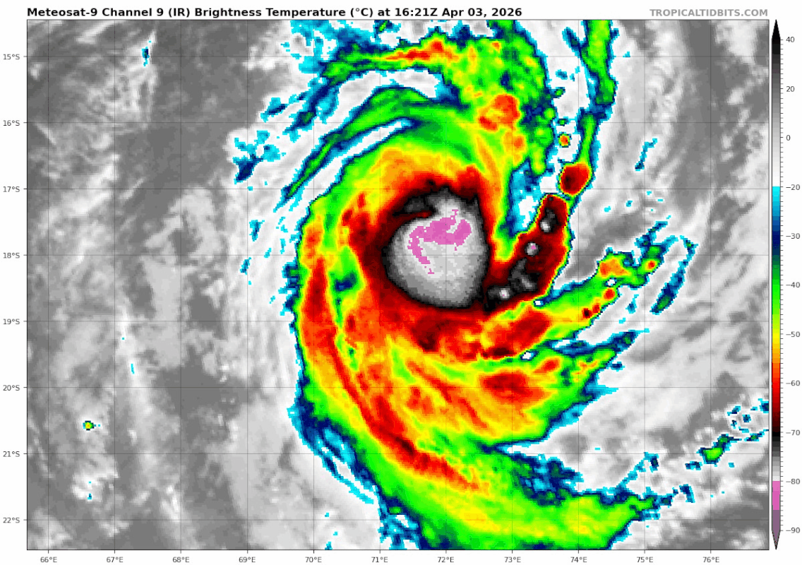
Re: SIO: INDUSA - Strong Tropical Storm
STRONG TROPICAL STORM INDUSA
Estimated maximum wind speeds (averaged over 10 minutes) at sea: 110 km/h.
Estimated maximum gusts at sea: 155 km/h.
Estimated pressure at the center: 987 hPa.
Position on April 3 at 4 p.m. local time: 16.5 South / 72.0 East.
Distance from the coast of Réunion: 1775 km to the East-Northeast sector
Distance from Mayotte: 2910 km to the East-Southeast sector
Movement: SOUTH-SOUTHWEST, at 30 km/h.
System information:
Tropical Storm INDUSA is located this Friday afternoon a little less than 1000 km
east-northeast of Rodrigues.
INDUSA is expected to continue moving south-southwest through tomorrow,
Saturday, while intensifying into a tropical cyclone. Afterward, the system is
expected to weaken, moving south and then southeast, gradually losing its
tropical characteristics early next week.
0 likes
Visit the Caribbean-Central America Weather Thread where you can find at first post web cams,radars
and observations from Caribbean basin members Click Here
and observations from Caribbean basin members Click Here

Re: SIO: INDUSA - Strong Tropical Storm
1 likes
TC naming lists: retirements and intensity
Most aggressive Advisory #1's in North Atlantic (cr. kevin for starting the list)
Most aggressive Advisory #1's in North Atlantic (cr. kevin for starting the list)
-
Hurricane2022

- Category 5

- Posts: 2083
- Joined: Tue Aug 23, 2022 11:38 pm
- Location: Araçatuba, Brazil
Re: SIO: INDUSA - Strong Tropical Storm
Likely peaking right now as a Category 1 Tropical Cyclome with a very small eye appearing occasionally. It will likely start to weaken later today as it reaches cooler waters while the wind shear intensifies.
0 likes
Sorry for the bad English sometimes...!
For reliable and detailed information for any meteorological phenomenon, please consult the National Hurricane Center, Joint Typhoon Warning Center , or your local Meteo Center.
--------
ECCE OMNIA NOVA FACIAM (Ap 21,5).
For reliable and detailed information for any meteorological phenomenon, please consult the National Hurricane Center, Joint Typhoon Warning Center , or your local Meteo Center.
--------
ECCE OMNIA NOVA FACIAM (Ap 21,5).
-
cycloneye
- Admin
- Posts: 149666
- Age: 69
- Joined: Thu Oct 10, 2002 10:54 am
- Location: San Juan, Puerto Rico
Re: SIO: INDUSA - Tropical Cyclone
INDUSA TROPICAL CYCLONE
Estimated maximum wind speeds (averaged over 10 minutes) at sea: 120 km/h.
Estimated maximum gusts at sea: 165 km/h.
Estimated pressure at the center: 978 hPa.
Position on April 4 at 04: 19.2 South / 70.7 East.
Distance from the coast of Réunion: 1560 km to the East sector
Distance from Mayotte: 2810 km to the East-Southeast sector
Movement: SOUTH-SOUTHWEST, at 30 km/h.
System information:
INDUSA intensified overnight and reached tropical cyclone status. The system
is currently located just under 800 km east of Rodrigues.
INDUSA is expected to continue moving south-southwest through Saturday
afternoon and reach its peak intensity by midday. Afterward, the system is
expected to weaken as it moves south and then southeast, gradually losing
its tropical characteristics early next week.
0 likes
Visit the Caribbean-Central America Weather Thread where you can find at first post web cams,radars
and observations from Caribbean basin members Click Here
and observations from Caribbean basin members Click Here
-
cycloneye
- Admin
- Posts: 149666
- Age: 69
- Joined: Thu Oct 10, 2002 10:54 am
- Location: San Juan, Puerto Rico
Re: SIO: INDUSA - Tropical Cyclone

1 likes
Visit the Caribbean-Central America Weather Thread where you can find at first post web cams,radars
and observations from Caribbean basin members Click Here
and observations from Caribbean basin members Click Here


Re: SIO: INDUSA - Tropical Cyclone
Made it to Cat-2 equivalent with a pinhole eye that was very barely visible. Too bad the early dry air entrainment killed its chance of reaching major status.
2 likes
Who is online
Users browsing this forum: No registered users and 69 guests