Texas Spring 2026
Moderator: S2k Moderators
Forum rules

The posts in this forum are NOT official forecast and should not be used as such. They are just the opinion of the poster and may or may not be backed by sound meteorological data. They are NOT endorsed by any professional institution or STORM2K.


Re: Texas Spring 2026
57 so far for a high today, well below normal for once. It has been a beautiful day, bring on the rain!
5 likes
The above post and any post by Ntxw is NOT an official forecast and should not be used as such. It is just the opinion of the poster and may or may not be backed by sound meteorological data. It is NOT endorsed by any professional institution including Storm2k. For official information, please refer to NWS products.
Help support Storm2K!
-
Brent
- S2K Supporter

- Posts: 38753
- Age: 37
- Joined: Sun May 16, 2004 10:30 pm
- Location: Tulsa Oklahoma
- Contact:
Re: Texas Spring 2026
Easter looking kind of chilly right now  you can't even make this stuff up
0 likes
#neversummer
-
Stratton23
- Category 5

- Posts: 3563
- Joined: Fri Jul 21, 2023 10:59 pm
- Location: Katy, Tx
Re: Texas Spring 2026
Meh, newest WPC rainfall outlook is pathetic, im not convinced we are going to see much in the way of rain, global models continue to be rather unimpressed
0 likes
-
wxman22

- Category 5
- Posts: 1941
- Joined: Mon Jan 30, 2006 12:39 am
- Location: Wichita Falls, TX
- Contact:
Re: Texas Spring 2026
Stratton23 wrote:Meh, newest WPC rainfall outlook is pathetic, im not convinced we are going to see much in the way of rain, global models continue to be rather unimpressed
I'm assuming youre referring to SE Texas. As models still look good up here for a few rounds of rain this week.
0 likes
-
Stratton23
- Category 5
- Posts: 3563
- Joined: Fri Jul 21, 2023 10:59 pm
- Location: Katy, Tx
Re: Texas Spring 2026
wxman22 really for central and se texas, less than 1.5 inches in most spot, that wouldnt be enough to even put a scratch in drought conditions
0 likes
-
txtwister78

- Category 5
- Posts: 2200
- Joined: Wed Jan 30, 2019 12:56 pm
- Location: San Antonio
Re: Texas Spring 2026
Stratton23 wrote:wxman22 really for central and se texas, less than 1.5 inches in most spot, that wouldnt be enough to even put a scratch in drought conditions
You're not going to get it all in one week anyway as it relates to the drought but global models have also been nothing but inconsistent with totals and part of that is a result of issues with the split flow pattern along with where the frontal boundary eventually stalls late next week.
But again rain is liquid gold right now for many and picking up an inch or two is still better than the alternative which is nothing??? April continues to look active so more opportunities likely on the way despite the two ahead during the upcoming week which will likely exceed models in a few regions.
2 likes
-
wxman22
- Category 5
- Posts: 1941
- Joined: Mon Jan 30, 2006 12:39 am
- Location: Wichita Falls, TX
- Contact:
Re: Texas Spring 2026
Stratton23 wrote:wxman22 really for central and se texas, less than 1.5 inches in most spot, that wouldnt be enough to even put a scratch in drought conditions
That's not bad, as long as the rainy pattern lasts it will chip away at the drought. We gotta start somewhere. A flood or drought buster this week was never on the menu to begin with.
We wont get rain everyday. But as long as this pattern lasts a while where we have a storm system every few days or so and as soil moisture starts to increase we *may eventually see a flooding threat down the road though.
1 likes
-
wxman22
- Category 5
- Posts: 1941
- Joined: Mon Jan 30, 2006 12:39 am
- Location: Wichita Falls, TX
- Contact:
Re: Texas Spring 2026
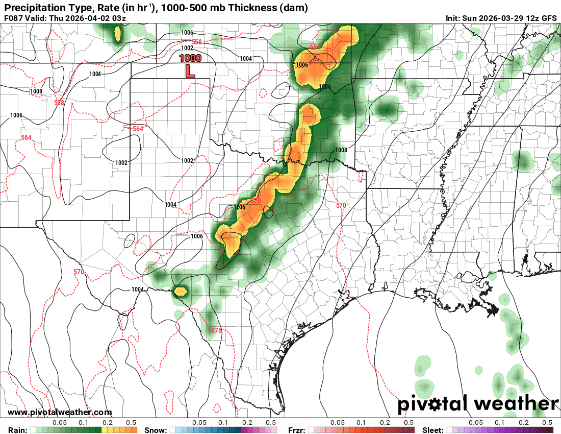
The global models have been showing a Squall Line or MCS developing along the front Wednesday night. With the next system after that coming around Friday/Saturday.
0 likes
-
txtwister78
- Category 5
- Posts: 2200
- Joined: Wed Jan 30, 2019 12:56 pm
- Location: San Antonio
Re: Texas Spring 2026
AFD from NWS Austin/San Antonio. Sounds pretty encouraging to me.
LONG TERM...
(Tuesday through next Sunday)
Issued at 1205 PM CDT Sun Mar 29 2026
The forecast for South Central Texas FINALLY starts to get interesting as we turn the calendar to April. Medium range guidance has started to increase coverage of showers and storms Wednesday evening through Thursday morning as a cold front works south into our area late Wednesday.
An upper trough will migrate east Wednesday, sending the aforementioned cold front into our region Wednesday night. Pooling of surface moisture and PWATs in the 1.25-1.50" range (some 1-2 SDs above the mean for early April) will result in thunderstorms developing along this frontal boundary. Some locally heavy rainfall is possible with these storms, but it's still a bit too early to tell whether or not a severe threat will materialize.
A second cold front, this one stronger, will arrive on Saturday night, bringing with it an even better chance for rain and storms. A majority of medium range guidance, including the AIGFS, AI ECMWF, GFS/ECMWF, GEM, and ensemble members have latched onto this front and widespread showers and storms for the weekend, particularly Saturday night into the day Sunday. At this distance, there is still quite a bit of time to narrow in on the best window of opportunity when it comes to storms next weekend. Cooler temperatures are also expected behind this front, along with gusty northeasterly winds.
0 likes
-
txtwister78
- Category 5
- Posts: 2200
- Joined: Wed Jan 30, 2019 12:56 pm
- Location: San Antonio
Re: Texas Spring 2026
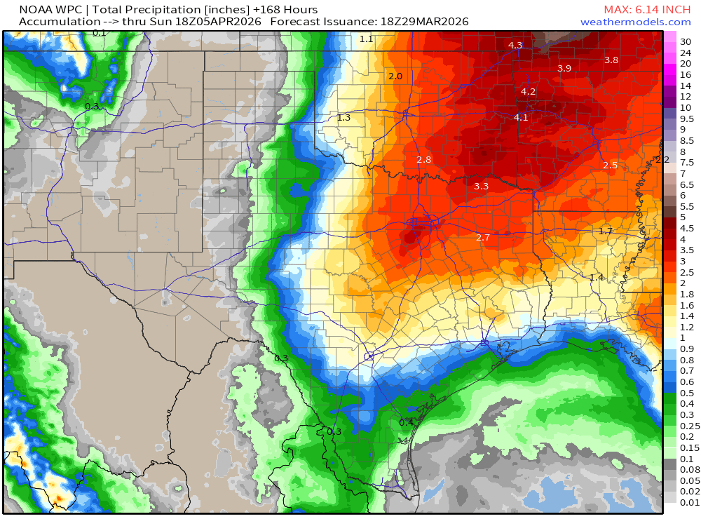
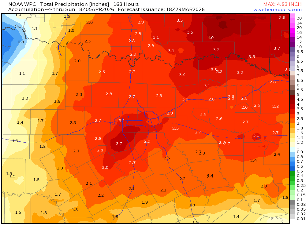
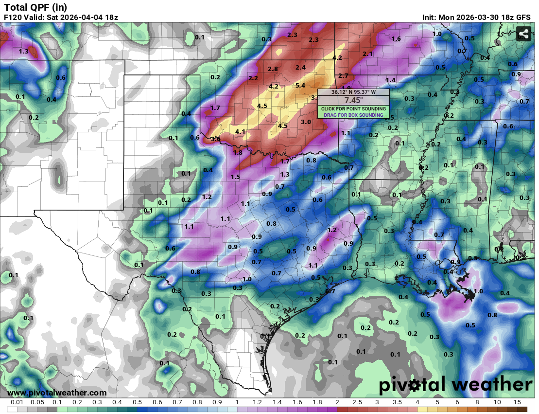
Exhibit A on the latest GFS of why you trust the pattern and don't model chase. 7 day total rainfall on the latest GFS continues to trend in a positive direction for central and portions of SC TX (it gets even better beyond 7 days) but if one had just gone off this model a few days ago you would of thought "what rain".
Yes things will still change a bit but we're getting to a point where models should begin to lock in in on a solution for the upcoming week and with that things are definitely on the right track for a good many across the state. Bring it!
Yes things will still change a bit but we're getting to a point where models should begin to lock in in on a solution for the upcoming week and with that things are definitely on the right track for a good many across the state. Bring it!
4 likes
Re: Texas Spring 2026
With the month exiting, it has a been a hot and mostly dry one. Will visit the numbers after tomorrow.
Moisture is increasing across the southern plains as we enter the next couple of weeks that will feature a more spring-like wetter pattern. Not everyone will see copious amounts of rain, but most should see 1-3" by mid-April. A corridor in the northeastern part of the state seems to be favored for 3+ which is where climo usually has it. By the end of the month a more consistent El Nino-like pattern should start setting up shop, cooler (or less hot however you want to view it) and wetter south. It's a slow grind to get there but will start with many more cloudy days, will be first sign.
Things will change. There is a pretty clear signal significant El Nino building is underway and the rising/sinking motion in the tropics is currently on path to reshuffle the global pattern. It's the wait that is painful given how many of us are tired of the old stagnant hot and dry/feast/famine ordeal for so long. I wouldn't be surprised if April or May saw a 10-15+ total in the one of the major sites (DFW/SAT/AUS/HOU) etc like in 1957, 1982, 1997, and 2015. 2015 got started early as there was already El Nino features in Feb that extended to June. 1957, 1982 and 1997 started in April and May and extended through summer, I think we are following the timeline closer to these three years.
2 likes
The above post and any post by Ntxw is NOT an official forecast and should not be used as such. It is just the opinion of the poster and may or may not be backed by sound meteorological data. It is NOT endorsed by any professional institution including Storm2k. For official information, please refer to NWS products.
Help support Storm2K!
Help support Storm2K!
Re: Texas Spring 2026
Also of note, all of the years I posted above had significant tornado events. 2015 was by numbers (and December) and the most by count in North Texas. 1957 had the infamous Dallas tornado in April. 1982 has the F4 Paris tornado, 1997 we all know about Jarrell.
All this to say with lots of rain in the spring months, more storms = more potential by sheer volume. Just something to ponder. They may not have the flashy outbreaks like in a La Nina but locally oncoming big El Nino years do have threats for our state.
All this to say with lots of rain in the spring months, more storms = more potential by sheer volume. Just something to ponder. They may not have the flashy outbreaks like in a La Nina but locally oncoming big El Nino years do have threats for our state.
1 likes
The above post and any post by Ntxw is NOT an official forecast and should not be used as such. It is just the opinion of the poster and may or may not be backed by sound meteorological data. It is NOT endorsed by any professional institution including Storm2k. For official information, please refer to NWS products.
Help support Storm2K!
Help support Storm2K!
-
HockeyTx82
- S2K Supporter
- Posts: 2795
- Joined: Tue Oct 27, 2009 11:17 am
- Location: Ponder, TX
Re: Texas Spring 2026
Ntxw wrote:Also of note, all of the years I posted above had significant tornado events. 2015 was by numbers (and December) and the most by count in North Texas. 1957 had the infamous Dallas tornado in April. 1982 has the F4 Paris tornado, 1997 we all know about Jarrell.
All this to say with lots of rain in the spring months, more storms = more potential by sheer volume. Just something to ponder. They may not have the flashy outbreaks like in a La Nina but locally oncoming big El Nino years do have threats for our state.
Ponder, that's where I live. Why are you sending something to Ponder?
1 likes
Don't hold me accountable for anything I post on this forum. Leave the real forecasting up to the professionals.
Location: Ponder, TX (all observation posts are this location unless otherwise noted)
Location: Ponder, TX (all observation posts are this location unless otherwise noted)
-
wxman22
- Category 5
- Posts: 1941
- Joined: Mon Jan 30, 2006 12:39 am
- Location: Wichita Falls, TX
- Contact:
Re: Texas Spring 2026
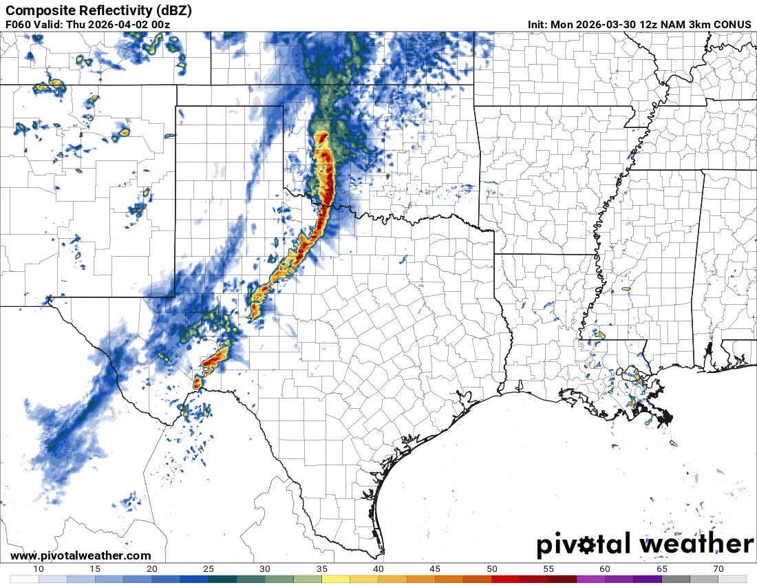
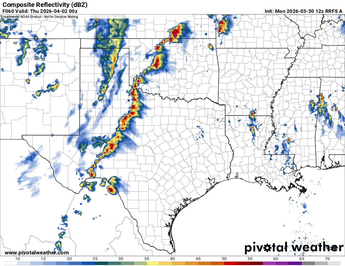
We’re in range of the CAMS. Both the NAM and RRFS show the squall line the globals have been showing Wednesday evening.
0 likes
-
txtwister78
- Category 5
- Posts: 2200
- Joined: Wed Jan 30, 2019 12:56 pm
- Location: San Antonio
Re: Texas Spring 2026
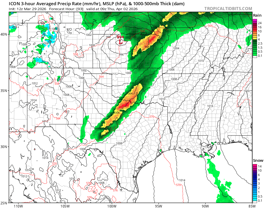
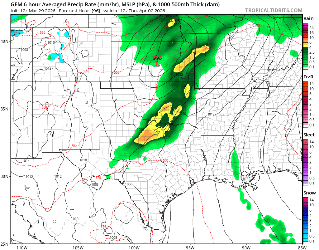
wxman22 wrote:We’re in range of the CAMS. Both the NAM and RRFS show the squall line the globals have been showing Wednesday evening.
https://i.postimg.cc/SQ3Cq1dq/IMG_0712.png
https://i.postimg.cc/15F6z074/IMG_0713.png
Fortunately severe weather mid week looks more isolated/conditional based as parameters (for now) don't look as impressive. That could still change as models sometimes underestimate instability until day of.
The other factor is timing and so for the prospect of more rainfall/storms we need to watch to see if we can speed this first short wave up a little bit more so we can maximize whatever instability is available. 2nd system later in the week could be different.
Regardless models now showing 2 inches generally across SC TX and HC with some isolated higher totals possible through Sunday. I'll take it.
1 likes
-
wxman22
- Category 5
- Posts: 1941
- Joined: Mon Jan 30, 2006 12:39 am
- Location: Wichita Falls, TX
- Contact:
Re: Texas Spring 2026
SPC upgraded NW Texas and parts of OK to a slight risk for Wednesday for the MCS.
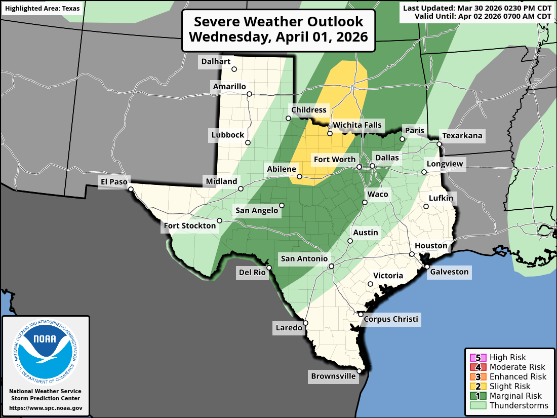
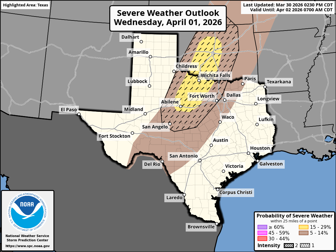
Day 3 Convective Outlook
NWS Storm Prediction Center Norman OK
0230 PM CDT Mon Mar 30 2026
Valid 011200Z - 021200Z
...THERE IS A SLIGHT RISK OF SEVERE THUNDERSTORMS ACROSS PARTS OF
THE SOUTHERN PLAINS...
...SUMMARY...
Severe thunderstorms are likely across the southern and central
Plains on Wednesday afternoon and evening. Severe wind gusts and
large hail are the primary concerns. Isolated strong/severe storms
are also possible over parts of the upper Ohio Valley into the
Mid-Atlantic.
...Southern and Central Plains...
A large-scale trough accompanied by 40-50-kt midlevel southwesterly
flow will move eastward from the Southwest/Great Basin across the
southern/central Plains through the period. At the same time, a lee
cyclone will deepen and track eastward across the central Plains,
while a southward-extending dryline makes little eastward
progression over the southern Plains. Ample diurnal heating and
parallel low-level flow to the dryline will support scattered
thunderstorm development by late afternoon as inhibition at the base
of the EML erodes. As the enhanced midlevel flow accompanying the
trough overspreads the dryline, effective shear should increase to
around 40 kt. The elongated hodographs and moderate surface-based
buoyancy should initially support semi-discrete supercells with a
risk of large hail and locally severe gusts. Soon after,
strengthening forcing for ascent preceding the trough should promote
upscale growth into clusters/lines and could develop into a severe
MCS. This would favor an increasing risk of severe gusts (some 75+
mph possible). Confidence in this scenario is currently highest over
parts of west/central OK into north TX, where a SLGT Risk was added.
0 likes
-
Iceresistance

- Category 5
- Posts: 9590
- Age: 22
- Joined: Sat Oct 10, 2020 9:45 am
- Location: Tecumseh, OK/Norman, OK
Re: Texas Spring 2026
0 likes
Bill 2015 & Beta 2020
Winter 2020-2021
All observations are in Tecumseh, OK unless otherwise noted.
Winter posts are focused mainly for Oklahoma & Texas.
Take any of my forecasts with a grain of salt, refer to the NWS, SPC, and NHC for official information
Never say Never with weather! Because ANYTHING is possible!
Winter 2020-2021
All observations are in Tecumseh, OK unless otherwise noted.
Winter posts are focused mainly for Oklahoma & Texas.
Take any of my forecasts with a grain of salt, refer to the NWS, SPC, and NHC for official information
Never say Never with weather! Because ANYTHING is possible!
-
wxman22
- Category 5
- Posts: 1941
- Joined: Mon Jan 30, 2006 12:39 am
- Location: Wichita Falls, TX
- Contact:
Re: Texas Spring 2026
I wouldn't rule out the possibility of an Enhanced Risk for winds on Wednesday.
0 likes
-
Edwards Limestone

- S2K Supporter
- Posts: 512
- Age: 36
- Joined: Tue Dec 28, 2021 11:05 am
- Location: Smithson Valley, TX
Re: Texas Spring 2026
I’m not sold on long term forecast. Not that it matters what I think, but the last few years have been brutal down here. It’s like the tap turned off in 2020 and save for some boom/bust cycles and extreme flooding locally, it’s been consistently dry. El Niños don’t always lead to increased rainfall for SCTX as we all saw a couple of years ago.
To me, it seems like the STJ has kind of shifted north the past few years bringing more storm tracks and rainfall to Oklahoma and north/northeast TX. I don’t know. The drought feedback down here is another hurdle to overcome. Years of below average rainfall eventually just becomes average.
That being said, I’ll take every drop we can get.
0 likes
The above post is NOT an official forecast and should not be used as such. It is just the opinion of the poster and may or may not be backed by sound meteorological data. It is NOT endorsed by any professional institution including Storm2k. For official information, please refer to NWS products.
Return to “USA & Caribbean Weather”
Who is online
Users browsing this forum: Brent, Stratton23 and 125 guests