

The mid to upper warmth in the atmosphere has been relentless, all layers really, reflecting at the surface de facto when it isn't raining. Essentially a cold season heat wave up there for months on end.


Moderator: S2k Moderators


rwfromkansas wrote:Hopefully we see some good storms tomorrow to wrap things up. Want another good rain since it looks dry the rest of the month.
Hoping some cap action can break before the main line.

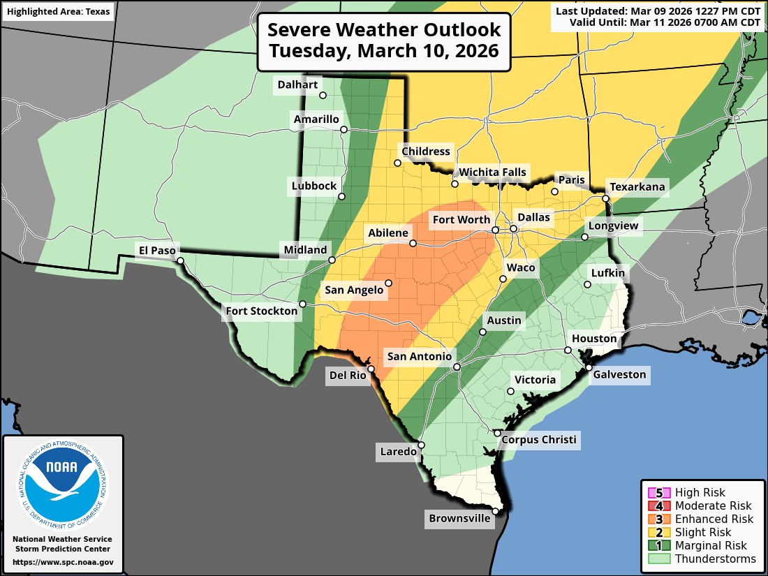
Day 2 Convective Outlook
NWS Storm Prediction Center Norman OK
1227 PM CDT Mon Mar 09 2026
Valid 101200Z - 111200Z
...THERE IS AN ENHANCED RISK OF SEVERE THUNDERSTORMS ACROSS CENTRAL
ILLINOIS INTO NORTHWEST INDIANA AND ACROSS THE EDWARDS PLATEAU INTO
CENTRAL TEXAS...
...SUMMARY...
Scattered severe thunderstorms are forecast on Tuesday from the
southern Plains into the southern Great Lakes vicinity. All severe
hazards are possible.
...Synopsis...
A bi-modal severe weather event is expected Tuesday afternoon and
evening across the Mid-West and portions of central Texas.
Mid-morning surface observations/analyses reveal a surface low
migrating eastward across the upper Great Lakes with a trailing cold
front draped southwestward into the central Plains. Weakening winds
behind the front suggest that this boundary will begin to stall
later today across the Midwest/central Plains. Meanwhile, returning
moisture is forecast to spread north over the next 24 hours as
surface pressure falls and southerly winds increase across the
Plains with the approach of the upper trough currently meandering
over Baja California and a slight amplification of the upper wave
over the north-central CONUS. This will help establish an expansive
warm sector from southern Texas northward into the central Plains
and Great Lakes region, bounded to the north by the stalled frontal
boundary and to the west by a weak dryline/Pacific front. Strong to
severe thunderstorms are expected within this warm sector as ascent
along the Midwest frontal zone and across the southern Plains
increases with the ejection of the upper trough late Tuesday
afternoon into Tuesday night. Southern Plains...
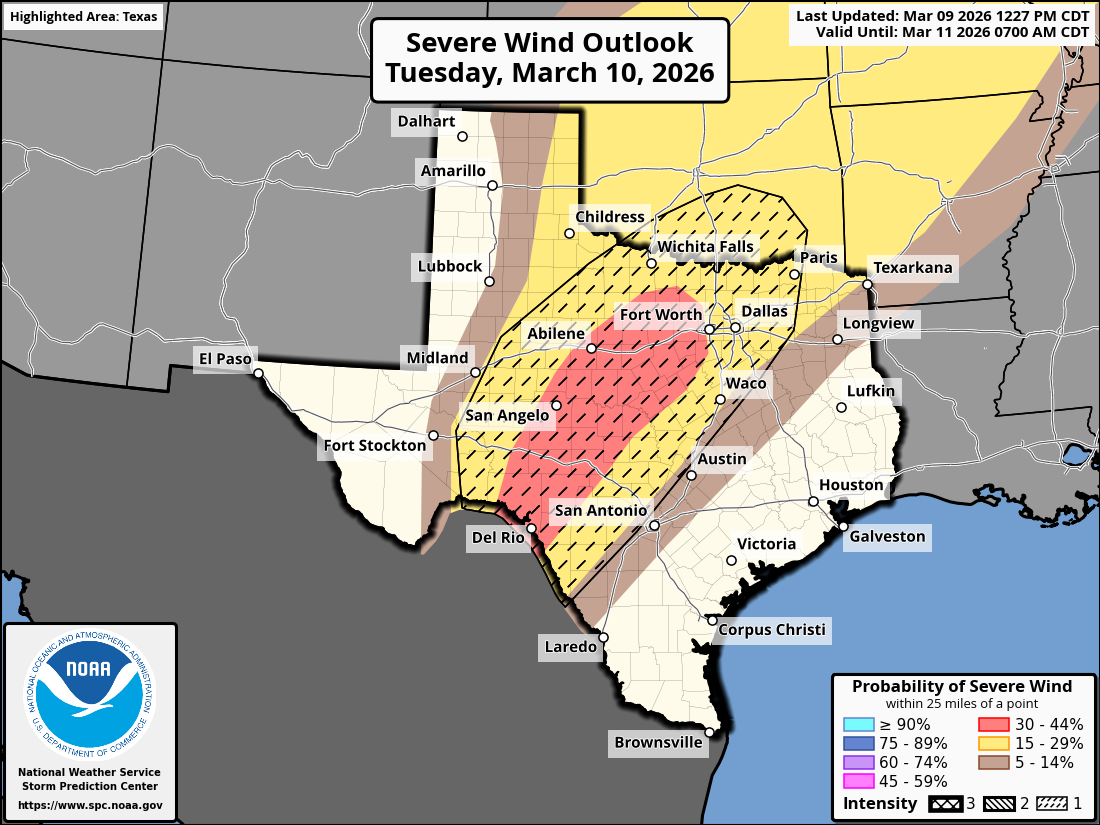
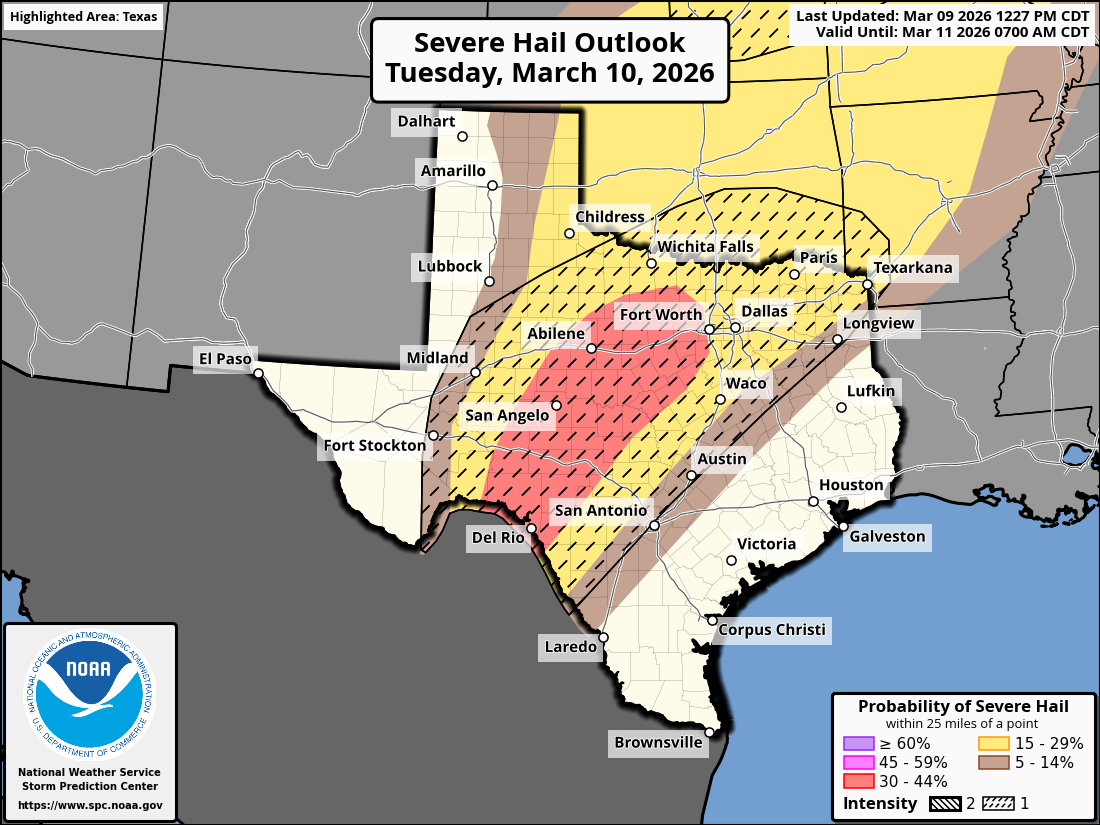
12 UTC soundings across the southern Plains sampled steep mid-level
lapse rates already in place across the region. The onset of deep
moisture return is noted along the TX Coastal Plain, which should
spread north across central TX into OK by Tuesday morning.
Isentropic ascent within the warm sector may support isolated
thunderstorm development by late morning across north TX into the
Texarkana region where capping should be weaker. By late
afternoon/early evening, more widespread thunderstorm development is
expected across central TX as strong height falls associated with
the ejecting upper wave overspread the region. Initially discrete
supercells will be capable of all hazards, through very large (2+
inch) hail appears to be the most probable threat. Strong forcing
for ascent will promote upscale growth through the evening with one
or more bowing segments possible. Enlarging low-level hodographs
associated with an increasing nocturnal jet may support embedded
circulations within the developing squall line. 30% hail/wind
probabilities were introduced to highlight the corridor of higher
hail/wind threat from the Edwards Plateau into central TX.
Return to “USA & Caribbean Weather”
Users browsing this forum: SnowyOwl31, Stratton23, wxman22 and 375 guests
