Texas Spring 2026

U.S. & Caribbean Weather Discussions and Severe Weather Events

Moderator: S2k Moderators

Forum rules

The posts in this forum are NOT official forecast and should not be used as such. They are just the opinion of the poster and may or may not be backed by sound meteorological data. They are NOT endorsed by any professional institution or STORM2K.

Help Support Storm2K
Message
Author
Golfisnoteasy75
Tropical Storm
Tropical Storm
Posts: 132
Joined: Mon Nov 17, 2025 5:31 pm

Re: Texas Spring 2026

#101 Postby Golfisnoteasy75 » Fri Mar 06, 2026 7:29 pm

Brent wrote:Lot of sirens here but it's been tracking northwest of me the whole time

At least it will apparently rain maybe. There were models with no rain this morning


Be careful!! Big tornado around you brent!!
0 likes   

User avatar
ElectricStorm
Category 5
Category 5
Posts: 5139
Age: 25
Joined: Tue Aug 13, 2019 11:23 pm
Location: Norman, OK

Re: Texas Spring 2026

#102 Postby ElectricStorm » Fri Mar 06, 2026 7:33 pm

Wow that debris ball just blew up significantly on the newest scan approaching Hwy 75 in north Tulsa
0 likes   
B.S Meteorology, University of Oklahoma '25

Please refer to the NHC, NWS, or SPC for official information.

Golfisnoteasy75
Tropical Storm
Tropical Storm
Posts: 132
Joined: Mon Nov 17, 2025 5:31 pm

Re: Texas Spring 2026

#103 Postby Golfisnoteasy75 » Fri Mar 06, 2026 7:34 pm

ElectricStorm wrote:Wow that debris ball just blew up significantly on the newest scan approaching Hwy 75 in north Tulsa


Brent lives close i believe
0 likes   

User avatar
Quixotic
Category 4
Category 4
Posts: 944
Joined: Tue Feb 14, 2017 12:27 am
Location: Frisco

Re: Texas Spring 2026

#104 Postby Quixotic » Fri Mar 06, 2026 7:47 pm

lol. tor watch canceled for DFW
0 likes   

Brent
S2K Supporter
S2K Supporter
Posts: 38729
Age: 37
Joined: Sun May 16, 2004 10:30 pm
Location: Tulsa Oklahoma
Contact:

Re: Texas Spring 2026

#105 Postby Brent » Fri Mar 06, 2026 8:09 pm

Golfisnoteasy75 wrote:
ElectricStorm wrote:Wow that debris ball just blew up significantly on the newest scan approaching Hwy 75 in north Tulsa


Brent lives close i believe


Other side of the metro pretty much

I've barely even seen any lightning south of 44. Stuff is moving really quickly
0 likes   
#neversummer

Brent
S2K Supporter
S2K Supporter
Posts: 38729
Age: 37
Joined: Sun May 16, 2004 10:30 pm
Location: Tulsa Oklahoma
Contact:

Re: Texas Spring 2026

#106 Postby Brent » Fri Mar 06, 2026 11:09 pm

Looks like Beggs south of the city is the worst hit area with the reported deaths. Massive first responder response

No injuries in Tulsa per the mayor whatever happened

Damage looks fairly light otherwise I'm guessing
0 likes   
#neversummer

gpsnowman
S2K Supporter
S2K Supporter
Posts: 3368
Joined: Fri Jan 07, 2011 10:35 am
Location: Grand Prairie Tx

Re: Texas Spring 2026

#107 Postby gpsnowman » Sat Mar 07, 2026 8:43 am

Man the temp dropped 20 degrees in about an hour with strong winds and heavy rain. Beautiful.
1 likes   

User avatar
Ntxw
Storm2k Moderator
Storm2k Moderator
Posts: 23469
Joined: Wed Oct 21, 2009 6:34 pm
Location: DFW, Texas

Re: Texas Spring 2026

#108 Postby Ntxw » Sat Mar 07, 2026 9:14 am

gpsnowman wrote:Man the temp dropped 20 degrees in about an hour with strong winds and heavy rain. Beautiful.


All my windows are open. After one hot and muggy start to March it felt really nice!
1 likes   
The above post and any post by Ntxw is NOT an official forecast and should not be used as such. It is just the opinion of the poster and may or may not be backed by sound meteorological data. It is NOT endorsed by any professional institution including Storm2k. For official information, please refer to NWS products.

  Help support Storm2K!
Help Support Storm2K

Brent
S2K Supporter
S2K Supporter
Posts: 38729
Age: 37
Joined: Sun May 16, 2004 10:30 pm
Location: Tulsa Oklahoma
Contact:

Re: Texas Spring 2026

#109 Postby Brent » Sat Mar 07, 2026 9:35 am

After tornado sirens on and off for 2 hours last night and other sirens going off for no reason(funny how they malfunction during a storm) the wind chill is now 34 :lol: feels amazing
0 likes   
#neversummer

User avatar
Edwards Limestone
S2K Supporter
S2K Supporter
Posts: 508
Age: 36
Joined: Tue Dec 28, 2021 11:05 am
Location: Smithson Valley, TX

Re: Texas Spring 2026

#110 Postby Edwards Limestone » Sat Mar 07, 2026 11:12 am

Forecasted totals decreasing across my area. Why am I not surprised.
1 likes   
The above post is NOT an official forecast and should not be used as such. It is just the opinion of the poster and may or may not be backed by sound meteorological data. It is NOT endorsed by any professional institution including Storm2k. For official information, please refer to NWS products.

Gotwood
Category 2
Category 2
Posts: 789
Joined: Wed Dec 14, 2022 7:18 pm
Location: Brock Tx

Re: Texas Spring 2026

#111 Postby Gotwood » Sat Mar 07, 2026 11:20 am

Less than a tenth of an inch at my house so far hopefully get some more in this next wave
0 likes   

TomballEd
Category 5
Category 5
Posts: 1263
Age: 62
Joined: Wed Aug 16, 2023 4:52 pm
Location: Spring/Klein area, not Tomball

Re: Texas Spring 2026

#112 Postby TomballEd » Sat Mar 07, 2026 11:21 am

My house is just inside the 15% and CIG 1 line for hail. The SPC site I Googled up ( https://www.spc.noaa.gov/exper/conditional-intensity-information/ ) describes CIG for tornadoes, not hail. So I don't really know what that means. 3 weeks without rain and my wife's SUV can go into the garage and my car is over 11 years old, I would accept anything an inch or under for the rain.


2md HRRR run in a row where my house is right on the screw zone boundary for today/tonight's thunderstorm event. High res 12Z NAM doesn't show any meaningful rain in metro Houston.
Image


Mid week looks interesting per SPC outlooks in North Texas/Oklahoma.
Image
0 likes   

rwfromkansas
Category 5
Category 5
Posts: 3021
Joined: Sat Aug 27, 2005 12:47 am
Location: North Fort Worth

Re: Texas Spring 2026

#113 Postby rwfromkansas » Sat Mar 07, 2026 11:26 am

Up to .90 for the week, so I will take it. Better than nothing and close to an inch.
0 likes   

gpsnowman
S2K Supporter
S2K Supporter
Posts: 3368
Joined: Fri Jan 07, 2011 10:35 am
Location: Grand Prairie Tx

Re: Texas Spring 2026

#114 Postby gpsnowman » Sat Mar 07, 2026 1:26 pm

Ntxw wrote:
gpsnowman wrote:Man the temp dropped 20 degrees in about an hour with strong winds and heavy rain. Beautiful.


All my windows are open. After one hot and muggy start to March it felt really nice!

Round 2 commencing. Big thunder at work in Coppell
0 likes   

User avatar
Iceresistance
Category 5
Category 5
Posts: 9579
Age: 22
Joined: Sat Oct 10, 2020 9:45 am
Location: Tecumseh, OK/Norman, OK

Re: Texas Spring 2026

#115 Postby Iceresistance » Sat Mar 07, 2026 1:28 pm

I had 1.7 inches of rain, mostly from the unexpectedly heavy storms from the front
0 likes   
Bill 2015 & Beta 2020

Winter 2020-2021 :cold:

All observations are in Tecumseh, OK unless otherwise noted.

Winter posts are focused mainly for Oklahoma & Texas.

Take any of my forecasts with a grain of salt, refer to the NWS, SPC, and NHC for official information

Never say Never with weather! Because ANYTHING is possible!

User avatar
Iceresistance
Category 5
Category 5
Posts: 9579
Age: 22
Joined: Sat Oct 10, 2020 9:45 am
Location: Tecumseh, OK/Norman, OK

Re: Texas Spring 2026

#116 Postby Iceresistance » Sat Mar 07, 2026 1:29 pm

TomballEd wrote:My house is just inside the 15% and CIG 1 line for hail. The SPC site I Googled up ( https://www.spc.noaa.gov/exper/conditional-intensity-information/ ) describes CIG for tornadoes, not hail. So I don't really know what that means. 3 weeks without rain and my wife's SUV can go into the garage and my car is over 11 years old, I would accept anything an inch or under for the rain.


2md HRRR run in a row where my house is right on the screw zone boundary for today/tonight's thunderstorm event. High res 12Z NAM doesn't show any meaningful rain in metro Houston.
https://i.imgur.com/EptiVIv.png


Mid week looks interesting per SPC outlooks in North Texas/Oklahoma.
https://i.imgur.com/uGgJFCt.png

I had people tell me that the hail cigs are 2 inch or greater on the Sig 1 line, and 3.5 inches and larger for the Sig 2 line for hail.
Again, not confirmed on how that works, but I won't be surprised if that's the case
1 likes   
Bill 2015 & Beta 2020

Winter 2020-2021 :cold:

All observations are in Tecumseh, OK unless otherwise noted.

Winter posts are focused mainly for Oklahoma & Texas.

Take any of my forecasts with a grain of salt, refer to the NWS, SPC, and NHC for official information

Never say Never with weather! Because ANYTHING is possible!

User avatar
wxman22
Category 5
Category 5
Posts: 1891
Joined: Mon Jan 30, 2006 12:39 am
Location: Wichita Falls, TX
Contact:

Re: Texas Spring 2026

#117 Postby wxman22 » Sat Mar 07, 2026 1:46 pm

Image

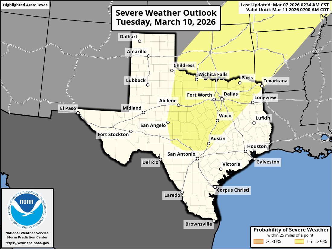
Day 4-8 Convective Outlook
NWS Storm Prediction Center Norman OK
0234 AM CST Sat Mar 07 2026

Valid 101200Z - 151200Z

...DISCUSSION...
...Days 4-5/Tue-Wed...

An active pattern with severe thunderstorm potential is expected
Tuesday and Wednesday from the southern Plains to the Mid/Lower MS
and OH Valleys. Medium range guidance is in fairly good agreement
during this time. Starting on Tuesday, an upper low over northern
Mexico will shift east/northeast, becoming an open wave as it begins
to merge with a northern stream upper trough developing southeast
across the northern/central Plains through early Wednesday. A belt
of strong southwesterly deep-layer flow will overspread a large warm
sector on Tuesday. Lee cyclogenesis is forecast across the
central/southern High Plains, along with a second surface low
developing over IA as the northern stream upper trough approaches.
This setup will allow for a sharpening dryline/Pacific front across
the southern Plains, while a cold front develops southeast into the
MO/Mid-MS Valley overnight. Strong ascent should focus thunderstorm
development across the warm sector ahead of these surface boundaries
within a strongly sheared environment, and potentially widespread
severe thunderstorm activity is possible.
0 likes   

User avatar
txtwister78
Category 5
Category 5
Posts: 2167
Joined: Wed Jan 30, 2019 12:56 pm
Location: San Antonio

Re: Texas Spring 2026

#118 Postby txtwister78 » Sat Mar 07, 2026 3:25 pm

Edwards Limestone wrote:Forecasted totals decreasing across my area. Why am I not surprised.


Cloud cover and a faster progression of the frontal boundary for you unfortunately but front is beginning to activate storm development across NW Bexar County points west. Good news down here.
0 likes   

TomballEd
Category 5
Category 5
Posts: 1263
Age: 62
Joined: Wed Aug 16, 2023 4:52 pm
Location: Spring/Klein area, not Tomball

Re: Texas Spring 2026

#119 Postby TomballEd » Sat Mar 07, 2026 4:19 pm

txtwister78 wrote:
Edwards Limestone wrote:Forecasted totals decreasing across my area. Why am I not surprised.


Cloud cover and a faster progression of the frontal boundary for you unfortunately but front is beginning to activate storm development across NW Bexar County points west. Good news down here.


SPC says 40% chance of a watch for SCTX. RAP analyzes almost 2500 J/Kg of mixed layer CAPE

Image
0 likes   

User avatar
txtwister78
Category 5
Category 5
Posts: 2167
Joined: Wed Jan 30, 2019 12:56 pm
Location: San Antonio

Re: Texas Spring 2026

#120 Postby txtwister78 » Sat Mar 07, 2026 4:40 pm

WPC says localized flooding risk now across SA metro as well.
0 likes   


Return to “USA & Caribbean Weather”

Who is online

Users browsing this forum: SnowyOwl31, Tireman4, wxman22 and 317 guests