SIO: GEZANI - Tropical Cyclone


Moderators: hurricanetrack, S2k Moderators

Forum rules

The posts in this forum are NOT official forecast and should not be used as such. They are just the opinion of the poster and may or may not be backed by sound meteorological data. They are NOT endorsed by any professional institution or STORM2K.

Help Support Storm2K
Message
Author
User avatar
cycloneye
Admin
Admin
Posts: 148995
Age: 69
Joined: Thu Oct 10, 2002 10:54 am
Location: San Juan, Puerto Rico

Re: SIO: GEZANI - Moderate Tropical Storm

#21 Postby cycloneye » Mon Feb 09, 2026 4:53 am

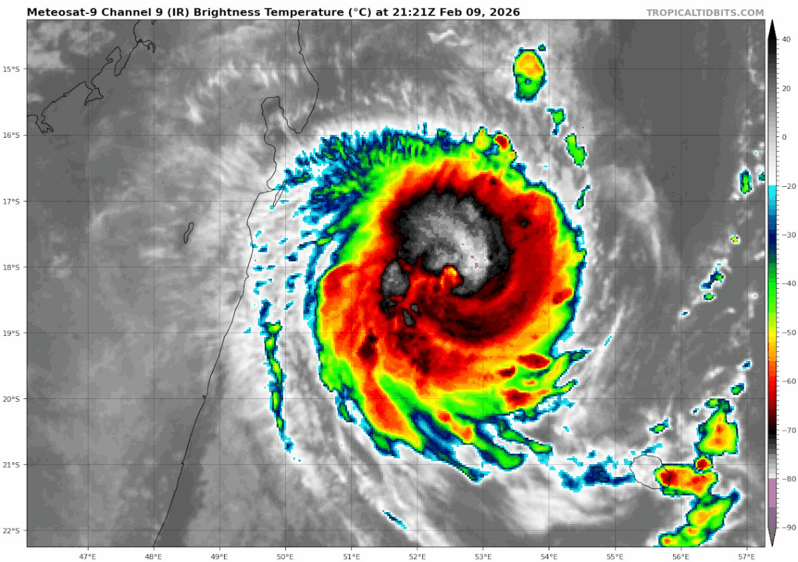
MODERATE TROPICAL STORM GEZANI


Estimated maximum wind speeds (averaged over 10 minutes) at sea: 75 km/h.

Estimated maximum gusts at sea: 100 km/h.

Estimated pressure at the center: 999 hPa.

Position on February 9 at 10 a.m. local time: 17.8 South / 54.8 East.

Distance from the coast of Réunion: 345 km to the NORTH-NORTHWEST sector

Distance from Mayotte: 1170 km to the East-Southeast sector

Movement: WEST, at 15 km/h.
0 likes   
Visit the Caribbean-Central America Weather Thread where you can find at first post web cams,radars
and observations from Caribbean basin members Click Here

User avatar
cycloneye
Admin
Admin
Posts: 148995
Age: 69
Joined: Thu Oct 10, 2002 10:54 am
Location: San Juan, Puerto Rico

Re: SIO: GEZANI - Moderate Tropical Storm

#22 Postby cycloneye » Mon Feb 09, 2026 5:44 am

0 likes   
Visit the Caribbean-Central America Weather Thread where you can find at first post web cams,radars
and observations from Caribbean basin members Click Here

User avatar
cycloneye
Admin
Admin
Posts: 148995
Age: 69
Joined: Thu Oct 10, 2002 10:54 am
Location: San Juan, Puerto Rico

Re: SIO: GEZANI - Severe Tropical Storm

#23 Postby cycloneye » Mon Feb 09, 2026 10:01 am

SEVERE TROPICAL STORM GEZANI


Estimated maximum wind speeds (averaged over 10 minutes) at sea: 95 km/h.

Estimated maximum gusts at sea: 130 km/h.

Estimated pressure at the center: 992 hPa.

Position on February 9 at 4 p.m. local time: 18.0 South / 53.9 East.

Distance from the coast of Réunion: 355 km to the NORTH-NORTHWEST sector

Distance from Mayotte: 1100 km to the East-Southeast sector

Movement: WEST, at 15 km/h.

System information:

- Gezani is currently at the stage of a strong tropical storm and continues to intensify as it moves away from the Mascarene Islands on a westward trajectory.

- On its westward trajectory, Gezani is expected to intensify steadily before reaching the east coast of Madagascar. It is forecast to make landfall near Toamasina as an intense tropical cyclone on Tuesday evening or the following night. It is possible to re-enter the channel starting Wednesday, followed by further intensification.

- In the longer term, a landing on the Mozambican coast remains very uncertain.
0 likes   
Visit the Caribbean-Central America Weather Thread where you can find at first post web cams,radars
and observations from Caribbean basin members Click Here

User avatar
DorkyMcDorkface
Category 4
Category 4
Posts: 972
Age: 28
Joined: Mon Sep 30, 2019 1:32 pm
Location: Mid-Atlantic

Re: SIO: GEZANI - Severe Tropical Storm

#24 Postby DorkyMcDorkface » Mon Feb 09, 2026 10:16 am

1 likes   
Please note the thougths expressed by this account are solely those of the user and are from a hobbyist perspective. For more comprehensive analysis, consult an actual professional meteorologist or meteorology agency.


Floyd 1999 | Isabel 2003 | Hanna 2008 | Irene 2011 | Sandy 2012 | Isaias 2020

User avatar
sasha_B
Category 1
Category 1
Posts: 309
Age: 25
Joined: Sun Jun 30, 2024 4:32 pm
Location: Charleston, SC

Re: SIO: GEZANI - Severe Tropical Storm

#25 Postby sasha_B » Mon Feb 09, 2026 12:03 pm

T4.0 from JTWC & it looks like the eye could close off soon - looks like RI is proceeding as forecast.
0 likes   

User avatar
cycloneye
Admin
Admin
Posts: 148995
Age: 69
Joined: Thu Oct 10, 2002 10:54 am
Location: San Juan, Puerto Rico

Re: SIO: GEZANI - Severe Tropical Storm

#26 Postby cycloneye » Mon Feb 09, 2026 12:30 pm

Boom!!

Image
2 likes   
Visit the Caribbean-Central America Weather Thread where you can find at first post web cams,radars
and observations from Caribbean basin members Click Here

User avatar
cycloneye
Admin
Admin
Posts: 148995
Age: 69
Joined: Thu Oct 10, 2002 10:54 am
Location: San Juan, Puerto Rico

Re: SIO: GEZANI - Severe Tropical Storm

#27 Postby cycloneye » Mon Feb 09, 2026 3:17 pm

SEVERE TROPICAL STORM GEZANI


Estimated maximum wind speeds (averaged over 10 minutes) at sea: 110 km/h.

Estimated maximum gusts at sea: 155 km/h.

Estimated pressure at the center: 985 hPa.

Position on February 9 at 10 p.m. local time: 18.0 South / 52.9 East.

Distance from the coast of Réunion: 405 km to the NORTH-WEST sector

Distance from Mayotte: 1010 km to the SOUTH-EAST sector

Movement: WEST, at 19 km/h.

System information:

- Gezani is currently at the stage of a strong tropical storm and continues to intensify as it moves away from the Mascarene Islands on a westward trajectory.

- On its westward trajectory, Gezani is expected to intensify steadily before reaching the east coast of Madagascar. It is forecast to make landfall near Toamasina as an intense tropical cyclone on Tuesday evening or the following night. It is possible to re-enter the channel starting Wednesday, followed by further intensification.
0 likes   
Visit the Caribbean-Central America Weather Thread where you can find at first post web cams,radars
and observations from Caribbean basin members Click Here

User avatar
sasha_B
Category 1
Category 1
Posts: 309
Age: 25
Joined: Sun Jun 30, 2024 4:32 pm
Location: Charleston, SC

Re: SIO: GEZANI - Severe Tropical Storm

#28 Postby sasha_B » Mon Feb 09, 2026 5:53 pm

Gezani's eye is beginning to clear out on SWIR imagery & is warming on WV and LWIR as well, though it is still a little ragged. Based on the last MW pass suggesting a tight RMW, and a DT 4.5 (E5.0 minus 0.5 eye adjustment), I'd estimate its current intensity at around 80 kt and 976 hPa as of 2230z. The eye is very small and the estimates from ADT are no longer representative at the moment, IMO.
1 likes   

User avatar
cycloneye
Admin
Admin
Posts: 148995
Age: 69
Joined: Thu Oct 10, 2002 10:54 am
Location: San Juan, Puerto Rico

Re: SIO: GEZANI - Severe Tropical Storm

#29 Postby cycloneye » Mon Feb 09, 2026 6:57 pm

0 likes   
Visit the Caribbean-Central America Weather Thread where you can find at first post web cams,radars
and observations from Caribbean basin members Click Here

User avatar
cycloneye
Admin
Admin
Posts: 148995
Age: 69
Joined: Thu Oct 10, 2002 10:54 am
Location: San Juan, Puerto Rico

Re: SIO: GEZANI - Tropical Cyclone

#30 Postby cycloneye » Mon Feb 09, 2026 7:34 pm

Tropical Cyclone Gezani


Estimated maximum wind speeds (averaged over 10 minutes) at sea: 150 km/h.

Estimated maximum gusts at sea: 215 km/h.

Estimated pressure at the center: 975 hPa.

Position on February 10 at 04:00 local time: 18.2 South / 52.0 East.

Distance from the coast of Réunion: 460 km to the NORTH-WEST sector

Distance from Mayotte: 940 km to the SOUTH-EAST sector

Movement: WEST, at 17 km/h.

System information:

- Gezani has intensified to the stage of a tropical cyclone and is maintaining its westward trajectory as it moves away from the Mascarene Islands.

- On its westward trajectory, Gezani is expected to continue intensifying before reaching the east coast of Madagascar. It is forecast to make landfall near Toamasina as an intense tropical cyclone on Tuesday evening or the following night. It is possible to re-enter the channel starting Wednesday, followed by further intensification.
0 likes   
Visit the Caribbean-Central America Weather Thread where you can find at first post web cams,radars
and observations from Caribbean basin members Click Here

User avatar
cycloneye
Admin
Admin
Posts: 148995
Age: 69
Joined: Thu Oct 10, 2002 10:54 am
Location: San Juan, Puerto Rico

Re: SIO: GEZANI - Tropical Cyclone

#31 Postby cycloneye » Mon Feb 09, 2026 8:12 pm

21S GEZANI 260210 0000 18.2S 52.1E SHEM 90 973


Image
3 likes   
Visit the Caribbean-Central America Weather Thread where you can find at first post web cams,radars
and observations from Caribbean basin members Click Here

User avatar
sasha_B
Category 1
Category 1
Posts: 309
Age: 25
Joined: Sun Jun 30, 2024 4:32 pm
Location: Charleston, SC

Re: SIO: GEZANI - Tropical Cyclone

#32 Postby sasha_B » Mon Feb 09, 2026 8:56 pm

Wow. The new microwave frames from 0040z confirm a very tight, very strong core. The upgrade from JTWC was entirely warranted, and puts Gezani 15 kt ahead of its forecast intensity of 75 kt for this point in time....does not bode well for intensity at landfall. We are certainly approaching MH-equivalent status now - the CI 5.0 is based on constraints, and raw DT would justify T5.5 (DG eye surrounded by LG w/ B ring), and surface pressure continues to drop at Toamasina Ambalamanasy Airport (FMMT).

Gezani is just the most recent of several Southern Hemisphere RI cases we've seen over the past 6 weeks - and while Dudzai didn't quite match Errol 2025's performance, it's starting to look like we're in the middle of another serious SH cyclone season.
2 likes   

User avatar
Teban54
Category 5
Category 5
Posts: 3795
Joined: Sat May 19, 2018 1:19 pm

Re: SIO: GEZANI - Tropical Cyclone

#33 Postby Teban54 » Tue Feb 10, 2026 12:00 am

Image
0 likes   


Return to “Active Storms - SE Indian Ocean, Arabian Sea/Bay of Bengal, SouthPAC”

Who is online

Users browsing this forum: No registered users and 10 guests