Winter Weather Discussion
Moderator: S2k Moderators
Forum rules
 The posts in this forum are NOT official forecast and should not be used as such.
 They are just the opinion of the poster and may or may not be backed by sound meteorological data. They are NOT endorsed by any professional institution or
STORM2K.
-
Stonewood Ranch
- Tropical Wave

- Posts: 7
- Joined: Thu Jun 15, 2023 4:35 pm
#4081 Postby Stonewood Ranch » Thu Jan 22, 2026 10:33 pm
Ntxw wrote:I get it warm nose is a warm nose but man, I just don't recall seeing 10-18F and a warm nose preventing snow. That's just insane.
Question for you experts…Is there any sign of the warm nose getting weaker & weaker after each recent model run? Could it be just a sleet and snow event for DFW with no freezing rain?
1 likes
-
TomballEd
- Category 5

- Posts: 1188
- Age: 62
- Joined: Wed Aug 16, 2023 4:52 pm
- Location: Spring/Klein area, not Tomball
#4082 Postby TomballEd » Thu Jan 22, 2026 10:37 pm
Stonewood Ranch wrote:Ntxw wrote:I get it warm nose is a warm nose but man, I just don't recall seeing 10-18F and a warm nose preventing snow. That's just insane.
Question for you experts…Is there any sign of the warm nose getting weaker & weaker after each recent model run? Could it be just a sleet and snow event for DFW with no freezing rain?
15*F and freezing drizzle in Houston in the 2021 winter storm. Looked a little like snow in the street lights, but it was just micro pieces of ice light enough to float a bit. I've seen snow flurries in NY, I know the difference.
2 likes
-
Quixotic
- Category 3

- Posts: 877
- Joined: Tue Feb 14, 2017 12:27 am
- Location: Frisco
#4083 Postby Quixotic » Thu Jan 22, 2026 10:40 pm
Ntxw wrote:I get it warm nose is a warm nose but man, I just don't recall seeing 10-18F and a warm nose preventing snow. That's just insane.
It’s possible. Not likely but possible. Like you said before conditions for snow have to be nearly perfect to get the confluence of moisture and cold at all levels. We are barely above sea level. We need southerly or sw flow for moisture and cold from top to bottom. Mid levels is hard to get moisture and not have some above freezing temps. The answer to me has always been a phase or semi phase where the northern jet interacts with the subtropical one.
3 likes
-
Quixotic
- Category 3
- Posts: 877
- Joined: Tue Feb 14, 2017 12:27 am
- Location: Frisco
#4084 Postby Quixotic » Thu Jan 22, 2026 10:42 pm
TomballEd wrote:Stonewood Ranch wrote:Ntxw wrote:I get it warm nose is a warm nose but man, I just don't recall seeing 10-18F and a warm nose preventing snow. That's just insane.
Question for you experts…Is there any sign of the warm nose getting weaker & weaker after each recent model run? Could it be just a sleet and snow event for DFW with no freezing rain?
15*F and freezing drizzle in Houston in the 2021 winter storm. Looked a little like snow in the street lights, but it was just micro pieces of ice light enough to float a bit. I've seen snow flurries in NY, I know the difference.
Doesn’t count. Freezing drizzle is surface based and cold wringing out moisture.
3 likes
-
TropicalTundra
- S2K Supporter

- Posts: 725
- Joined: Wed Oct 16, 2019 12:56 pm
- Location: Temple, Texas
#4085 Postby TropicalTundra » Thu Jan 22, 2026 10:44 pm
TomballEd wrote:Stonewood Ranch wrote:Ntxw wrote:I get it warm nose is a warm nose but man, I just don't recall seeing 10-18F and a warm nose preventing snow. That's just insane.
Question for you experts…Is there any sign of the warm nose getting weaker & weaker after each recent model run? Could it be just a sleet and snow event for DFW with no freezing rain?
15*F and freezing drizzle in Houston in the 2021 winter storm. Looked a little like snow in the street lights, but it was just micro pieces of ice light enough to float a bit. I've seen snow flurries in NY, I know the difference.
There was a mix here of freezing rain and sleet at 9 degrees that same storm. Wind chill was brutal and all the sleet that fell practically created an ice layer on top of the 3 day old snow, found that out the hard way lol.
Last edited by
TropicalTundra on Thu Jan 22, 2026 10:45 pm, edited 1 time in total.
1 likes
Snow in Texas? What’s that?
Don't use my posts as forecast; I'm not a certified meteorologist! I just endorse cold weather, alright?
All observations I note are for Temple, Texas unless otherwise stated.
-
Ntxw
- Storm2k Moderator

- Posts: 23344
- Joined: Wed Oct 21, 2009 6:34 pm
- Location: DFW, Texas
#4086 Postby Ntxw » Thu Jan 22, 2026 10:45 pm
Quixotic wrote:Ntxw wrote:I get it warm nose is a warm nose but man, I just don't recall seeing 10-18F and a warm nose preventing snow. That's just insane.
It’s possible. Not likely but possible. Like you said before conditions for snow have to be nearly perfect to get the confluence of moisture and cold at all levels. We are barely above sea level. We need southerly or sw flow for moisture and cold from top to bottom. Mid levels is hard to get moisture and not have some above freezing temps. The answer to me has always been a phase or semi phase where the northern jet interacts with the subtropical one.
Yeah but to get that low typically means you are deeper in the cold air mass there is some correlation. Maybe it will be a learning curve experience.
8 likes
The above post and any post by Ntxw is NOT an official forecast and should not be used as such. It is just the opinion of the poster and may or may not be backed by sound meteorological data. It is NOT endorsed by any professional institution including Storm2k. For official information, please refer to NWS products.
Help support Storm2K!

-
Quixotic
- Category 3
- Posts: 877
- Joined: Tue Feb 14, 2017 12:27 am
- Location: Frisco
#4087 Postby Quixotic » Thu Jan 22, 2026 10:51 pm
Stonewood Ranch wrote:Ntxw wrote:I get it warm nose is a warm nose but man, I just don't recall seeing 10-18F and a warm nose preventing snow. That's just insane.
Question for you experts…Is there any sign of the warm nose getting weaker & weaker after each recent model run? Could it be just a sleet and snow event for DFW with no freezing rain?
I’m not good at interpreting skew-ts so I can’t help you there. As I said previously we need help with a deeper cold mass without drying things out (unlikely) or help from some type of phase/quasi-phase with the northern stream (more likely).
Take my advice and listen to people who not only get paid for it but their entire professional reputation is at stake when they forecast: NWS. People can say “yeah they busted” but did they really? With every event you can pick a point and say “bust” but I bet you for the watch area as a whole, they did not.
3 likes
-
downsouthman1
- Category 2

- Posts: 677
- Age: 46
- Joined: Fri Jan 07, 2011 8:14 pm
- Location: Rowlett, TX
#4088 Postby downsouthman1 » Thu Jan 22, 2026 10:52 pm
Ntxw wrote:Quixotic wrote:Ntxw wrote:I get it warm nose is a warm nose but man, I just don't recall seeing 10-18F and a warm nose preventing snow. That's just insane.
It’s possible. Not likely but possible. Like you said before conditions for snow have to be nearly perfect to get the confluence of moisture and cold at all levels. We are barely above sea level. We need southerly or sw flow for moisture and cold from top to bottom. Mid levels is hard to get moisture and not have some above freezing temps. The answer to me has always been a phase or semi phase where the northern jet interacts with the subtropical one.
Yeah but to get that low typically means you are deeper in the cold air mass there is some correlation. Maybe it will be a learning curve experience.
I have not seen an event play out with this level of QPF with the Temps forecast and not wind up with snow. Not with a ULL passing by. So if that happens, wow but a bad wow.
2 likes
Not a professional MET! My posts are merely speculation.
-
orangeblood
- S2K Supporter
- Posts: 3843
- Joined: Tue Dec 15, 2009 6:14 pm
- Location: Fort Worth, TX
#4089 Postby orangeblood » Thu Jan 22, 2026 10:55 pm
GFS deeper cold/further south with ejection. Clear trend developing today and this evening
4 likes
-
wxman22
- Category 5
- Posts: 1800
- Joined: Mon Jan 30, 2006 12:39 am
- Location: Wichita Falls, TX
-
Contact:
#4090 Postby wxman22 » Thu Jan 22, 2026 10:56 pm
ICON

3 likes
-
Quixotic
- Category 3
- Posts: 877
- Joined: Tue Feb 14, 2017 12:27 am
- Location: Frisco
#4092 Postby Quixotic » Thu Jan 22, 2026 10:59 pm
Ntxw wrote:Quixotic wrote:Ntxw wrote:I get it warm nose is a warm nose but man, I just don't recall seeing 10-18F and a warm nose preventing snow. That's just insane.
It’s possible. Not likely but possible. Like you said before conditions for snow have to be nearly perfect to get the confluence of moisture and cold at all levels. We are barely above sea level. We need southerly or sw flow for moisture and cold from top to bottom. Mid levels is hard to get moisture and not have some above freezing temps. The answer to me has always been a phase or semi phase where the northern jet interacts with the subtropical one.
Yeah but to get that low typically means you are deeper in the cold air mass there is some correlation. Maybe it will be a learning curve experience.
Yeah. You’re absolutely right. Another dumb anecdote from me but I remember my car breaking down and it was 16. Thinking this was 1996. I remember the temp because I was on a payphone near a bank and it would flash the temp and time. Getting clobbered with sleet. To me a nose is something like 10 degrees warmer which gives us about 26 in the mid levels. Then again, in February 86, it was 50 degrees and snowing. (¯\_(ツ)_/)
0 likes
-
wxman22
- Category 5
- Posts: 1800
- Joined: Mon Jan 30, 2006 12:39 am
- Location: Wichita Falls, TX
-
Contact:
#4093 Postby wxman22 » Thu Jan 22, 2026 10:59 pm
0z GFS


4 likes
-
Iceresistance
- Category 5
- Posts: 9536
- Age: 22
- Joined: Sat Oct 10, 2020 9:45 am
- Location: Tecumseh, OK/Norman, OK
#4094 Postby Iceresistance » Thu Jan 22, 2026 11:00 pm
Fort Smith, AR gets like, 2 feet from this

2 likes
Bill 2015 & Beta 2020
Winter 2020-2021 
All observations are in Tecumseh, OK unless otherwise noted.
Winter posts are focused mainly for Oklahoma & Texas.
Take any of my forecasts with a grain of salt, refer to the NWS, SPC, and NHC for official information
Never say
Never with weather! Because
ANYTHING is possible!
-
Quixotic
- Category 3
- Posts: 877
- Joined: Tue Feb 14, 2017 12:27 am
- Location: Frisco
#4095 Postby Quixotic » Thu Jan 22, 2026 11:02 pm
I want all of Tulsa’s 16 inches.
6 likes
-
DukeMu
- Tropical Storm

- Posts: 102
- Joined: Thu Jun 01, 2023 2:48 pm
- Location: College Station, TX
#4096 Postby DukeMu » Thu Jan 22, 2026 11:04 pm
That backside is a beast!
3 likes
-
jasons2k
- Storm2k Executive

- Posts: 8274
- Age: 52
- Joined: Wed Jul 06, 2005 12:32 pm
- Location: The Woodlands, TX
#4097 Postby jasons2k » Thu Jan 22, 2026 11:05 pm
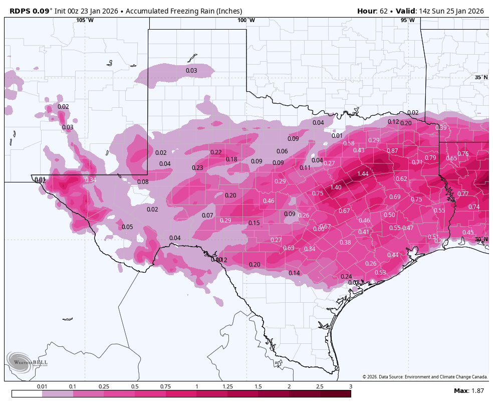
Down to 29 in Dalhart. You can see where the frontal-genesis is taking place as the lobe of thin, cold air slices down the caprock like a knife. It’s 29 in Spearman with a stiff NNE wind, but still 37 in Pampa with winds from the SE.
4 likes
-
Quixotic
- Category 3
- Posts: 877
- Joined: Tue Feb 14, 2017 12:27 am
- Location: Frisco
#4098 Postby Quixotic » Thu Jan 22, 2026 11:06 pm
CaptinCrunch wrote:jasons2k wrote:The freezing line is now in the NW Texas panhandle.
I have to disagree as to were the surface front is actually located. The front is just south or a line from Topeka KS to Lincoln KS. The dew points will drop to single digits in the cold dry air, plus the winds are pretty gusty with the front as it moves through.
Lincoln KS 30FHumidity 40%
Wind Speed NE 23 G 28 mph
Barometer 30.27 in
Dewpoint 9°F (-13°C)Visibility 10.00 mi
Wind Chill 17°F (-8°C)
Last update 22 Jan 8:35 pm CST
Topeka KS 30FHumidity 41%
Wind Speed N 14 mph
Barometer 30.31 in (1027.6 mb)
Dewpoint 9°F (-13°C)Visibility 10.00 mi
Wind Chill 19°F (-7°C)
Last update 22 Jan 7:53 pm CST
Tulsa OK 47FHumidity 36%
Wind Speed SE 3 mph
Barometer 30.16 in (1021.5 mb)
Dewpoint 21°F (-6°C)Visibility 10.00 mi
Last update 22 Jan 7:53 pm CST
Gage OK 39FHumidity 82%
Wind Speed S 7 mph
Barometer 30.08 in (1019.7 mb)
Dewpoint 34°F (1°C)Visibility 10.00 mi
Wind Chill 34°F (1°C)
Last update 22 Jan 7:53 pm CST
Dalhart TX 37F Topography
Humidity 46%
Wind Speed NE 12 mph
Barometer 30.06 in (1018.3 mb)
Dewpoint 18°F (-8°C)Visibility 10.00 mi
Wind Chill 29°F (-2°C)
Last update 22 Jan 7:53 pm CST
Thank you for reminding us how crucial dewpoints are in winter weather. Seriously.
3 likes
-
DukeMu
- Tropical Storm
- Posts: 102
- Joined: Thu Jun 01, 2023 2:48 pm
- Location: College Station, TX
#4099 Postby DukeMu » Thu Jan 22, 2026 11:08 pm
0 likes
-
Iceresistance
- Category 5
- Posts: 9536
- Age: 22
- Joined: Sat Oct 10, 2020 9:45 am
- Location: Tecumseh, OK/Norman, OK
#4100 Postby Iceresistance » Thu Jan 22, 2026 11:11 pm
Okay wow, that escalated very quickly
 https://s12.gifyu.com/images/bk3LW.gif
0 likes
Bill 2015 & Beta 2020
Winter 2020-2021 All observations are in Tecumseh, OK unless otherwise noted.
Winter posts are focused mainly for Oklahoma & Texas.
Take any of my forecasts with a grain of salt, refer to the NWS, SPC, and NHC for official information
Never say
Never with weather! Because
ANYTHING is possible!
Return to “Winter Weather”
Who is online
Users browsing this forum: 869MB, AnnularCane, Brent, CaptinCrunch, Captmorg70, cheezyWXguy, Cpv17, CSpringer, cstrunk, downsouthman1, GeauxTigers, Google Adsense [Bot], Gotwood, Harp.1, iorange55, kassi, Longhornmaniac8, Lynx, Marion Morrison, Ntxw, Quixotic, Ralph's Weather, ravyrn, rendihess, rwfromkansas, snownado, Texas Snowman, TropicalTundra, txtwister78, UTSARoadrunner4, WeatherP1, wwizard and 280 guests


