Haris wrote:Yall have to root for the slow deep 18z gfs
It's also very far south almost to Cabo with the base of the ULL. This is what I was hoping the trend would be eventually.
Moderator: S2k Moderators
 The posts in this forum are NOT official forecast and should not be used as such. They are just the opinion of the poster and may or may not be backed by sound meteorological data. They are NOT endorsed by any professional institution or STORM2K.
Haris wrote:Yall have to root for the slow deep 18z gfs


Ntxw wrote:Iceresistance wrote:I forgot to ask/mention this, but don't the models tend to overestimate the warm nose in winter weather events?
You need a warm nose in some form of fashion for moisture transport. That's what overruning precipitation is, warm moist air going over cooler air below. Higher the QPF involved the warmer the moisture transport from a tropics and subtropics that's just physics. There's a Goldilocks zone somewhere around maybe a quarter inch to 3/4 in of QPF where it's just enough to not overwhelm but not too little where is dry. Just a basic layman's, there's a lot more nuances involved at the upper levels. Can they overestimate yes that means the model is too wet and the colder surface wins vice versa.

Ntxw wrote:Think we will like the 18z GFS a little more.


Ntxw wrote:Haris wrote:Yall have to root for the slow deep 18z gfs
It's also very far south almost to Cabo with the base of the ULL. This is what I was hoping the trend would be eventually.
HockeyTx82 wrote:Ntxw wrote:Haris wrote:Yall have to root for the slow deep 18z gfs
It's also very far south almost to Cabo with the base of the ULL. This is what I was hoping the trend would be eventually.
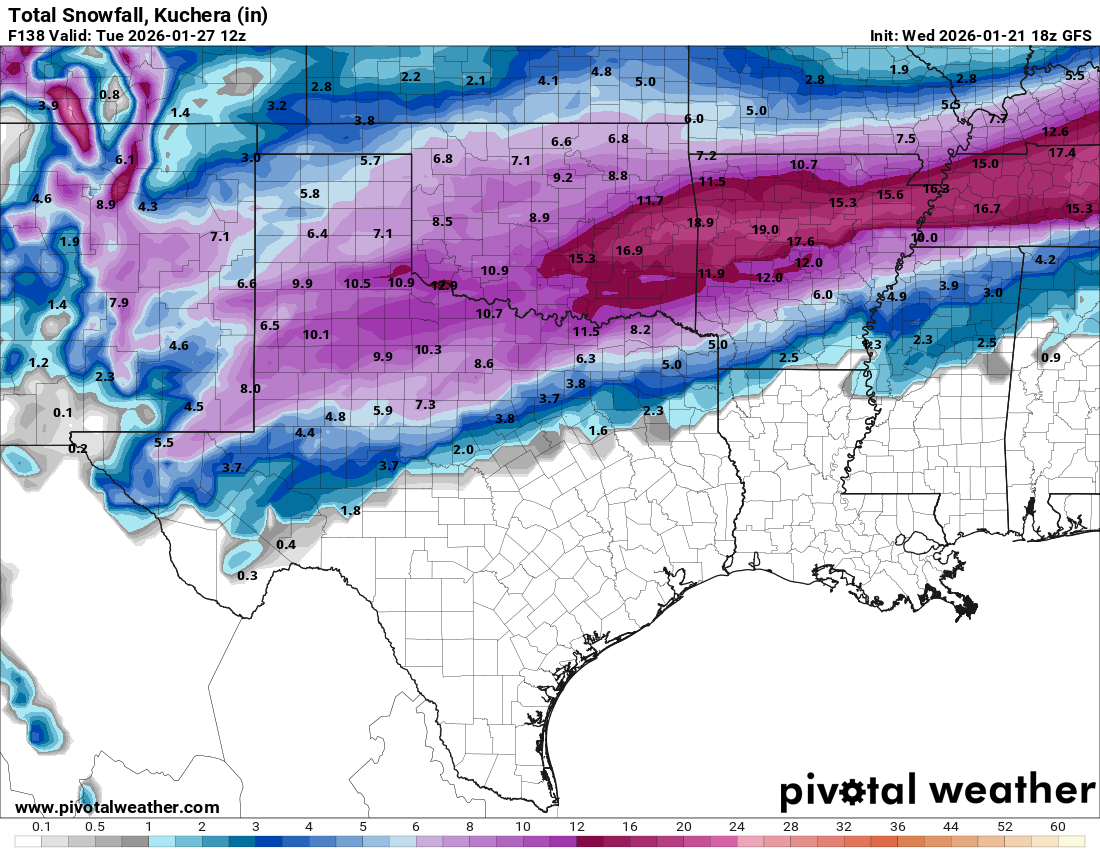
So trends are looking like what for DFW?

Quixotic wrote:Ridiculous to think this but what if we get a pounding with sleet and then top it off with WSW level snow? I don’t think I’ve ever seen that.

HockeyTx82 wrote:Ntxw wrote:Haris wrote:Yall have to root for the slow deep 18z gfs
It's also very far south almost to Cabo with the base of the ULL. This is what I was hoping the trend would be eventually.
So trends are looking like what for DFW?

Quixotic wrote:Ridiculous to think this but what if we get a pounding with sleet and then top it off with WSW level snow? I don’t think I’ve ever seen that.
cheezyWXguy wrote:Quixotic wrote:Ridiculous to think this but what if we get a pounding with sleet and then top it off with WSW level snow? I don’t think I’ve ever seen that.
This seems to be plausible given the runs today. If the nam is right on the faster front, then we should see the bulk of the qpf falls as sleet, with a few inches of snow on top at the end. I wonder what ratios could be in play by Sunday given the temps, would be cool to see a 50/50 split between sleet and snow accumulations, but I’m getting ahead of myself here.

Ntxw wrote:To stray a little bit from the storm, The 500 millibar pattern is looking even better and better on the weeklies for the middle of February. Very low heights across the eastern US starting out in the plains extending to the Atlantic Ocean. This 500 millibar configuration is snowy historically for the month of February possibly one of the most highest correlated of our analogs. You're talking stuff like February 2010 and 1978 in terms of storms and quality of cold air. Just something to keep in mind as this period continues to trend this way.
https://i.imgur.com/dTSJmSy.jpeg
Quixotic wrote:Ntxw wrote:When we talk about 77-78 what’s amazing to me was the consistency of the cold and the entire column was cold. No sleet. No freezing rain. Just straight to snow. I was a kid in the inner city of Dallas and it seemed like it snowed almost every day. My parents said it was like being back in Worcester.

Quixotic wrote:BTW, FWD shifted that mostly snow line ever so slightly south as it bisects Denton and Collin.
Ntxw wrote:Quixotic wrote:Ntxw wrote:When we talk about 77-78 what’s amazing to me was the consistency of the cold and the entire column was cold. No sleet. No freezing rain. Just straight to snow. I was a kid in the inner city of Dallas and it seemed like it snowed almost every day. My parents said it was like being back in Worcester.
Lower average heights means the atmosphere is generally colder than normal. You start cold, it will likely be cold when systems cross, just a better playing field. Surface can go through ebb and flow but mid February likely has deeper cold to work with above.
https://i.imgur.com/zlC8Fae.gif
Users browsing this forum: Google Adsense [Bot], Ralph's Weather and 136 guests