Winter Weather Discussion
Moderator: S2k Moderators
Forum rules
 The posts in this forum are NOT official forecast and should not be used as such.
 They are just the opinion of the poster and may or may not be backed by sound meteorological data. They are NOT endorsed by any professional institution or
STORM2K.
-
Ntxw
- Storm2k Moderator

- Posts: 23385
- Joined: Wed Oct 21, 2009 6:34 pm
- Location: DFW, Texas
#3201 Postby Ntxw » Tue Jan 20, 2026 10:19 pm
orangeblood wrote:NAM 3km is the one to follow from this point forward on surface temps IMO, it’s faster with the frz line and stronger with the Arctic HP currently. Precip can get wacky though but it’s good for temps at this range
Starting to get into view of FV3. I didn't mind this model during synoptic rain set ups during the past year.
3 likes
The above post and any post by Ntxw is NOT an official forecast and should not be used as such. It is just the opinion of the poster and may or may not be backed by sound meteorological data. It is NOT endorsed by any professional institution including Storm2k. For official information, please refer to NWS products.
Help support Storm2K!

-
Gotwood
- Category 2

- Posts: 762
- Joined: Wed Dec 14, 2022 7:18 pm
- Location: Brock Tx
#3202 Postby Gotwood » Tue Jan 20, 2026 10:19 pm
snownado wrote:Gotwood wrote:At the same time the conus NAM has OKC 4 degrees colder.
For sure, there's going to be a tight temperature gradient somewhere on the NW side of this thing regardless of where the storm tracks and where much of frozen precip sets up.
It's just a question of:
1. Are we starting to see this evolve into more of a SW to NE-oriented event.
2. Is the baroclinic zone going to settle further NW than what's currently projected.
But hoepfully, the NAM and EURO are out of touch and not starting to sniff out a trend (on the other hand, if going that direction gets us out of a crippling ice storm, then it might as well go all the way)
Good news is we still have a couple of days for this to iron its self out.
2 likes
-
Quixotic
- Category 3

- Posts: 889
- Joined: Tue Feb 14, 2017 12:27 am
- Location: Frisco
#3203 Postby Quixotic » Tue Jan 20, 2026 10:20 pm
gpsnowman wrote:Winter Storm Fern. Ha!
They tried “Begonia” but nobody could pronounce it.
5 likes
-
wxman22
- Category 5

- Posts: 1816
- Joined: Mon Jan 30, 2006 12:39 am
- Location: Wichita Falls, TX
-
Contact:
#3204 Postby wxman22 » Tue Jan 20, 2026 10:24 pm
Last frame of the 0z RGEM

3 likes
-
Quixotic
- Category 3
- Posts: 889
- Joined: Tue Feb 14, 2017 12:27 am
- Location: Frisco
#3205 Postby Quixotic » Tue Jan 20, 2026 10:26 pm
Gotwood wrote:5 inches of sleet? I’m not sure my mind can comprehend that lol.
Yeah. Had it in DFW 2003. It took a week to melt because fog would form and wouldn’t burn off until sunset. Rinse and repeat.
1 likes
-
gpsnowman
- S2K Supporter

- Posts: 3330
- Joined: Fri Jan 07, 2011 10:35 am
- Location: Grand Prairie Tx
#3206 Postby gpsnowman » Tue Jan 20, 2026 10:36 pm
Quixotic wrote:gpsnowman wrote:Winter Storm Fern. Ha!
They tried “Begonia” but nobody could pronounce it.
That will be our next storm.
1 likes
-
DukeMu
- Tropical Storm

- Posts: 107
- Joined: Thu Jun 01, 2023 2:48 pm
- Location: College Station, TX
#3207 Postby DukeMu » Tue Jan 20, 2026 10:43 pm
That looks familiar (back in the Carolinas - like every year). Some big live oaks are bough-ing (bowing) down. Pine trees also fair poorly.
0 likes
-
cycloneye
- Admin

- Posts: 148840
- Age: 69
- Joined: Thu Oct 10, 2002 10:54 am
- Location: San Juan, Puerto Rico
#3208 Postby cycloneye » Tue Jan 20, 2026 10:45 pm
Recon feeding the models with data.

5 likes
Visit the Caribbean-Central America Weather Thread where you can find at first post web cams,radars
and observations from Caribbean basin members
Click Here
-
snownado
- Category 5
- Posts: 1052
- Joined: Sat Dec 09, 2023 7:00 pm
- Location: Plano, TX
#3209 Postby snownado » Tue Jan 20, 2026 10:59 pm
Gotwood wrote:snownado wrote:Gotwood wrote:At the same time the conus NAM has OKC 4 degrees colder.
For sure, there's going to be a tight temperature gradient somewhere on the NW side of this thing regardless of where the storm tracks and where much of frozen precip sets up.
It's just a question of:
1. Are we starting to see this evolve into more of a SW to NE-oriented event.
2. Is the baroclinic zone going to settle further NW than what's currently projected.
But hoepfully, the NAM and EURO are out of touch and not starting to sniff out a trend (on the other hand, if going that direction gets us out of a crippling ice storm, then it might as well go all the way)
Good news is we still have a couple of days for this to iron its self out.
True.
And hopefully, the EE rule (IYKYK) doesn't come back to haunt us here.
1 likes
-
Stratton23
- Category 5
- Posts: 3397
- Joined: Fri Jul 21, 2023 10:59 pm
- Location: Katy, Tx
#3210 Postby Stratton23 » Tue Jan 20, 2026 11:03 pm
00z GFS looks more sleet/ snow, still some freezing rain, but trends are definitely better for sleet than ice
4 likes
-
funster
- Category 3
- Posts: 823
- Joined: Sat Dec 29, 2007 4:27 pm
- Location: North Dallas
#3211 Postby funster » Tue Jan 20, 2026 11:03 pm
If it intensifies then will it pull more moisture toward the center as well?
1 likes
-
wxman22
- Category 5
- Posts: 1816
- Joined: Mon Jan 30, 2006 12:39 am
- Location: Wichita Falls, TX
-
Contact:
#3212 Postby wxman22 » Tue Jan 20, 2026 11:07 pm
7 likes
-
gpsnowman
- S2K Supporter
- Posts: 3330
- Joined: Fri Jan 07, 2011 10:35 am
- Location: Grand Prairie Tx
#3213 Postby gpsnowman » Tue Jan 20, 2026 11:11 pm
Is thundersleet or thundersnow possible with this system?
2 likes
-
wxman22
- Category 5
- Posts: 1816
- Joined: Mon Jan 30, 2006 12:39 am
- Location: Wichita Falls, TX
-
Contact:
#3214 Postby wxman22 » Tue Jan 20, 2026 11:16 pm
gpsnowman wrote:Is thundersleet or thundersnow possible with this system?
Yes
3 likes
-
gpsnowman
- S2K Supporter
- Posts: 3330
- Joined: Fri Jan 07, 2011 10:35 am
- Location: Grand Prairie Tx
#3215 Postby gpsnowman » Tue Jan 20, 2026 11:17 pm
wxman22 wrote:gpsnowman wrote:Is thundersleet or thundersnow possible with this system?
Yes
Thank you kind sir. Looking forward to it
1 likes
-
Ptarmigan
- Category 5
- Posts: 5355
- Joined: Wed Aug 16, 2006 9:06 pm
#3216 Postby Ptarmigan » Tue Jan 20, 2026 11:17 pm
wxman22 wrote:gpsnowman wrote:Is thundersleet or thundersnow possible with this system?
Yes
Thundersnow or thundersleet is not a common thing.
0 likes
-
Quixotic
- Category 3
- Posts: 889
- Joined: Tue Feb 14, 2017 12:27 am
- Location: Frisco
#3217 Postby Quixotic » Tue Jan 20, 2026 11:18 pm
gpsnowman wrote:Is thundersleet or thundersnow possible with this system?
I saw some run earlier on Sunday that showed convection. I haven’t seen it since but once the high resolution models get in range look for the circles.
2 likes
-
wxman22
- Category 5
- Posts: 1816
- Joined: Mon Jan 30, 2006 12:39 am
- Location: Wichita Falls, TX
-
Contact:
#3218 Postby wxman22 » Tue Jan 20, 2026 11:19 pm
CMC

3 likes
-
Quixotic
- Category 3
- Posts: 889
- Joined: Tue Feb 14, 2017 12:27 am
- Location: Frisco
#3219 Postby Quixotic » Tue Jan 20, 2026 11:21 pm
That cmc run crushes me with 6” of sleet and then 7” of snow. I hope it kills my trees.
0 likes
-
Ntxw
- Storm2k Moderator
- Posts: 23385
- Joined: Wed Oct 21, 2009 6:34 pm
- Location: DFW, Texas
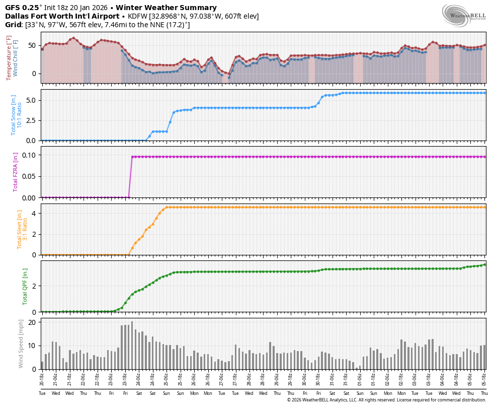
#3220 Postby Ntxw » Tue Jan 20, 2026 11:23 pm
GFS has the cmc beat with lows

.
3 likes
The above post and any post by Ntxw is NOT an official forecast and should not be used as such. It is just the opinion of the poster and may or may not be backed by sound meteorological data. It is NOT endorsed by any professional institution including Storm2k. For official information, please refer to NWS products.
Help support Storm2K!
Return to “Winter Weather”
Who is online
Users browsing this forum: bubba hotep, cajungal, CaptinCrunch, Coldandsnow, Cpv17, downsouthman1, FamousOrangeCat, Harp.1, HockeyTx82, jaguars_22, JayDT, Longhornmaniac8, rmic, South Texas Storms, Stratton23, TomballEd, Will_TX and 182 guests


