
95B INVEST 251120 1800 6.3N 99.2E IO 15 1008
WPAC: SENYAR - Post-Tropical
Moderator: S2k Moderators
WPAC: SENYAR - Post-Tropical
Last edited by Subtrop on Wed Nov 26, 2025 1:10 am, edited 1 time in total.
0 likes

Re: BoB: INVEST 95B
JMA also started doing EDA on this despite technically it's not on the Nwpac anymore, their coordinates are 4.08N,99.80E at 0600z.
1 likes
ヤンデレ女が寝取られるているのを見たい!!!
ECMWF ensemble NWPAC plots: https://ecmwfensnwpac.imgbb.com/
Multimodel NWPAC plots: https://multimodelnwpac.imgbb.com/
GFS Ensemble NWPAC plots (16 & 35 day forecast): https://gefsnwpac.imgbb.com/
Plots updated automatically
ECMWF ensemble NWPAC plots: https://ecmwfensnwpac.imgbb.com/
Multimodel NWPAC plots: https://multimodelnwpac.imgbb.com/
GFS Ensemble NWPAC plots (16 & 35 day forecast): https://gefsnwpac.imgbb.com/
Plots updated automatically
-
doomhaMwx

- Category 5

- Posts: 2496
- Age: 27
- Joined: Tue Apr 18, 2017 4:01 am
- Location: Baguio/Benguet, Philippines
- Contact:
Re: BoB: INVEST 95B
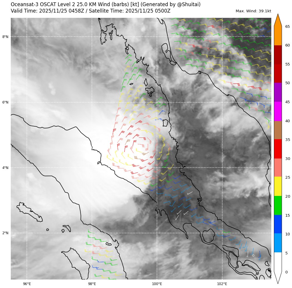
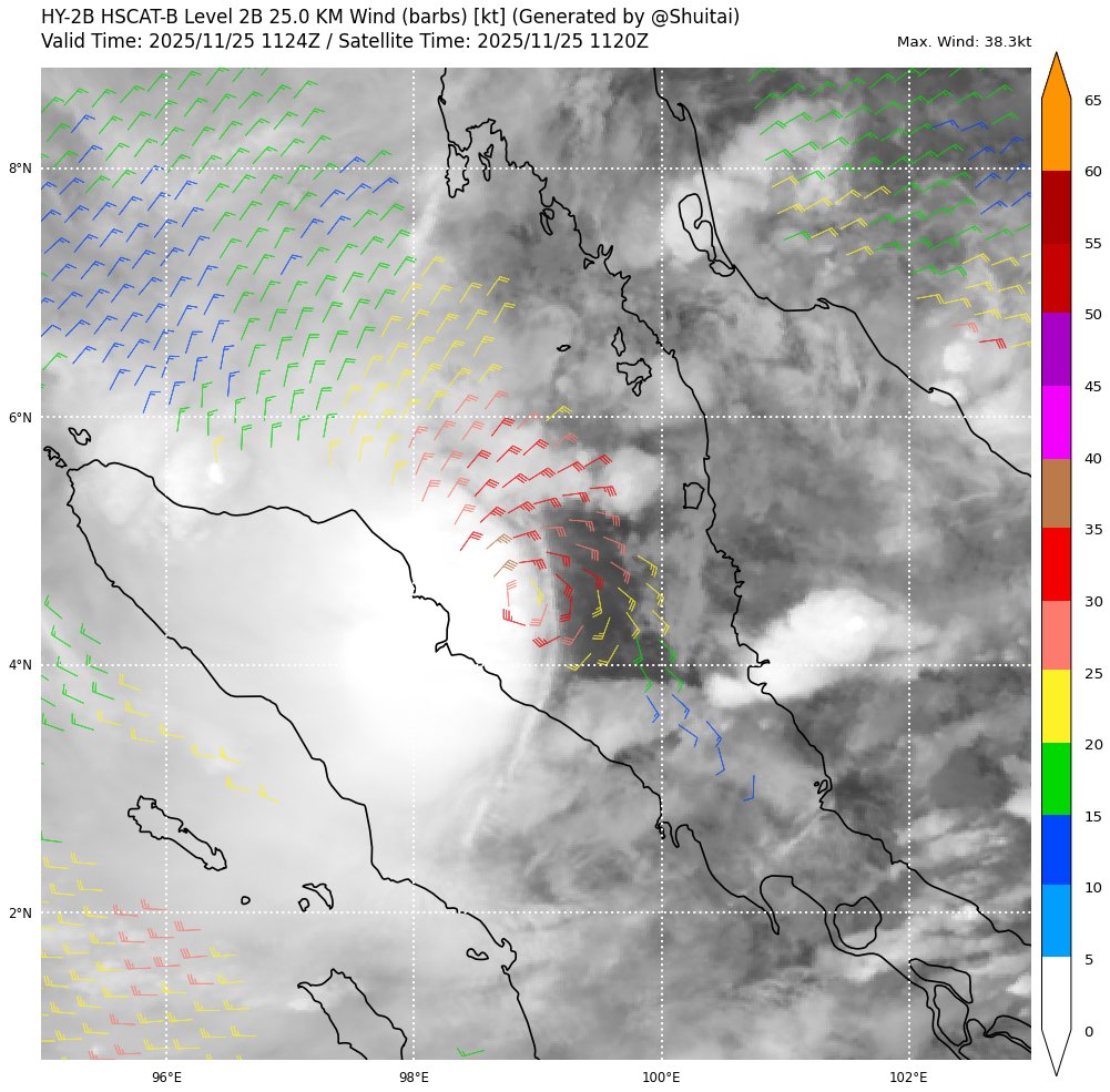
Pretty sure Invest 95B has been a tropical storm for a while now, albeit a sheared one, and at an extremely rare location — just below 5°N between Malaysia and Sumatra (Indonesia)! Fortunate to have successive scatterometer passes over the system today.


3 likes
-
AJC3

- Admin

- Posts: 4156
- Age: 62
- Joined: Tue Aug 31, 2004 7:04 pm
- Location: Ballston Spa, New York
- Contact:
Re: BoB: INVEST 95B
Some SIGNIFICANT best track reanalysis is warranted here. This is a pretty egregious whiff, albeit not surprising given it's in a rare TCG location, and at the border between RMSCs Tokyo and New Delhi.
2 likes
-
AJC3
- Admin
- Posts: 4156
- Age: 62
- Joined: Tue Aug 31, 2004 7:04 pm
- Location: Ballston Spa, New York
- Contact:
Re: BoB: TROPICAL CYCLONE 04B
Some pretty serious and sometimes horrific videos coming out from Thailand and Indonesia...
https://x.com/Top_Disaster/status/1992985835411816630
https://x.com/Top_Disaster/status/1993006925186056669
https://x.com/Top_Disaster/status/1993275111085162983
https://x.com/bbcindonesia/status/1993265908895432932
https://x.com/Top_Disaster/status/1993292620559532237
https://x.com/Top_Disaster/status/1992985835411816630
https://x.com/Top_Disaster/status/1993006925186056669
https://x.com/Top_Disaster/status/1993275111085162983
https://x.com/bbcindonesia/status/1993265908895432932
https://x.com/Top_Disaster/status/1993292620559532237
0 likes
-
wxman57

- Moderator-Pro Met

- Posts: 23176
- Age: 68
- Joined: Sat Jun 21, 2003 8:06 pm
- Location: Houston, TX (southwest)
Re: BoB: TROPICAL CYCLONE 04B
Note that the official classification from IMD is "Depression". They're the RSMC for the region. However, IMD is not the most reliable RSMC. Scatterometer data clearly has 35kt winds.
3 likes

Re: BoB: 04B - Deep Depression
Now a Deep Depression per IMD, TS per JTWC.
As per INSAT 3DS at 1800 UTC, intensity of the system is T2.0. Associated scattered to broken
low and medium clouds with embedded intense to very intense convection lay over south
Andaman Sea, north Sumatra, Strait of Malacca adjoining Malaysia & neighbourhood (minimum
CTT minus 70-90 degree Celsius). Scattered to broken low and medium clouds with embedded
intense to very intense convection lay over south Bay of Bengal and south Andaman Sea.
Scattered low and medium clouds with embedded moderate to intense convection lay over west
central Bay of Bengal and north Andaman Sea.
The estimated central pressure is about 1002 hPa. The associated maximum sustained wind
speed is about 25-30 knots gusting to 35 knots.
0 likes
-
StormWeather

- Category 1

- Posts: 477
- Joined: Wed Jun 05, 2024 2:34 pm
Re: BoB: TROPICAL CYCLONE 04B
Goes to show how unusual this cyclone is
THE TRACK AFTER TAU 12 BECOMES
HIGHLY UNCERTAIN DUE TO UNCERTAINTIES IN HOW THE LLCC WILL INTERACT
WITH THE RUGGED AND HIGH TERRAIN FEATURES OF NORTHERN SUMATRA AND
THE FACT THAT THIS REGION HAS NEVER HAD A DIRECT TC IMPACT BEFORE,
SO THERE IS NO DATA TO SUPPORT HOW THE VORTEX WILL MOVE AS IT
CROSSES THE TERRAIN FEATURES.
HIGHLY UNCERTAIN DUE TO UNCERTAINTIES IN HOW THE LLCC WILL INTERACT
WITH THE RUGGED AND HIGH TERRAIN FEATURES OF NORTHERN SUMATRA AND
THE FACT THAT THIS REGION HAS NEVER HAD A DIRECT TC IMPACT BEFORE,
SO THERE IS NO DATA TO SUPPORT HOW THE VORTEX WILL MOVE AS IT
CROSSES THE TERRAIN FEATURES.
3 likes
Just an average cyclone tracker
The posts in this forum are NOT official forecasts and should not be used as such. They are just the opinion of the poster and may or may not be backed by sound meteorological data. They are NOT endorsed by any professional institution or storm2k.org. For official information, please refer to the NHC and NWS products
The posts in this forum are NOT official forecasts and should not be used as such. They are just the opinion of the poster and may or may not be backed by sound meteorological data. They are NOT endorsed by any professional institution or storm2k.org. For official information, please refer to the NHC and NWS products

Re: BoB: INVEST 95B
doomhaMwx wrote:Pretty sure Invest 95B has been a tropical storm for a while now, albeit a sheared one, and at an extremely rare location — just below 5°N between Malaysia and Sumatra (Indonesia)! Fortunate to have successive scatterometer passes over the system today.
https://i.imgur.com/gIw6Lep.gif
https://pbs.twimg.com/media/G6mi1sbbwAoHQBT?format=jpg&name=medium
https://pbs.twimg.com/media/G6mi1tLaQAEQBq2?format=jpg&name=medium
https://pbs.twimg.com/media/G6mi1wnbwAIzHEw?format=jpg&name=medium
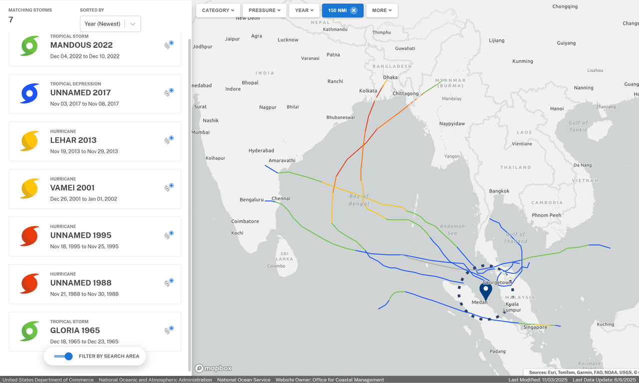
Using the approximate ASCAT location, here are all systems that passed within 150 nm of 04B's location. All went north of here except the similarly anomalous Vamei 2001 (whose formation was the closest to the equator on record).
2 likes
TC naming lists: retirements and intensity
Most aggressive Advisory #1's in North Atlantic (cr. kevin for starting the list)
Most aggressive Advisory #1's in North Atlantic (cr. kevin for starting the list)
-
AJC3
- Admin
- Posts: 4156
- Age: 62
- Joined: Tue Aug 31, 2004 7:04 pm
- Location: Ballston Spa, New York
- Contact:
Re: BoB: TROPICAL CYCLONE 04B
wxman57 wrote:Note that the official classification from IMD is "Depression". They're the RSMC for the region. However, IMD is not the most reliable RSMC. Scatterometer data clearly has 35kt winds.
Yep, again not surprising. And the fact that they assigned a 20kt intensity at 25/12Z given not one but THREE scatterometer passes from 10-12hr prior had some 40kt wind barbs...well that's just plain incompetent at best, and negligent at worst.
1 likes
Re: BoB: SENYAR - Cyclonic Storm
FKIN20 VIDP 260355
TC ADVISORY
TCAC: NEW DELHI
DTG: 20251126/0000Z
TC: SENYAR
NR: 02
PSN: N0500 E09800
MOV: W07KT
INTST CHANGE: INTSF
C: 999HPA
MAX WIND: 40KT
FCST PSN+06HR: 26/0600Z N0500 E09718
FCST MAX WIND +06HRS: 40 KT
FCST PSN+12HR: 26/1200Z N0454 E09648
FCST MAX WIND +12HRS: 40 KT
FCST PSN+18HR: 26/1800Z N0448 E09624
FCST MAX WIND +18HRS: 35 KT
FCST PSN+24HR: 27/0000Z N0436 E09636
FCST MAX WIND +24HRS: 35 KT
RMK: NIL
NEXT MSG: 20251126/0900Z
TOO: 260903HRS IST
1 likes
Re: BoB: SENYAR - Cyclonic Storm
Euro wants this to track over the SCS
0 likes
ヤンデレ女が寝取られるているのを見たい!!!
ECMWF ensemble NWPAC plots: https://ecmwfensnwpac.imgbb.com/
Multimodel NWPAC plots: https://multimodelnwpac.imgbb.com/
GFS Ensemble NWPAC plots (16 & 35 day forecast): https://gefsnwpac.imgbb.com/
Plots updated automatically
ECMWF ensemble NWPAC plots: https://ecmwfensnwpac.imgbb.com/
Multimodel NWPAC plots: https://multimodelnwpac.imgbb.com/
GFS Ensemble NWPAC plots (16 & 35 day forecast): https://gefsnwpac.imgbb.com/
Plots updated automatically
Re: WPAC: SENYAR - Tropical Depression
JMA 12Z
WWJP27 RJTD 271200
WARNING AND SUMMARY 271200.
WARNING VALID 281200.
WARNING IS UPDATED EVERY 6 HOURS.
TROPICAL DEPRESSION 1008 HPA AT 03N 101E EAST SLOWLY.
WARNING AND SUMMARY 271200.
WARNING VALID 281200.
WARNING IS UPDATED EVERY 6 HOURS.
TROPICAL DEPRESSION 1008 HPA AT 03N 101E EAST SLOWLY.
1 likes
ヤンデレ女が寝取られるているのを見たい!!!
ECMWF ensemble NWPAC plots: https://ecmwfensnwpac.imgbb.com/
Multimodel NWPAC plots: https://multimodelnwpac.imgbb.com/
GFS Ensemble NWPAC plots (16 & 35 day forecast): https://gefsnwpac.imgbb.com/
Plots updated automatically
ECMWF ensemble NWPAC plots: https://ecmwfensnwpac.imgbb.com/
Multimodel NWPAC plots: https://multimodelnwpac.imgbb.com/
GFS Ensemble NWPAC plots (16 & 35 day forecast): https://gefsnwpac.imgbb.com/
Plots updated automatically
-
MarioProtVI
- Category 5
- Posts: 1039
- Age: 24
- Joined: Sun Sep 29, 2019 7:33 pm
- Location: New Jersey
Re: WPAC: SENYAR - Tropical Depression
Hayabusa wrote:JMA 12ZWWJP27 RJTD 271200
WARNING AND SUMMARY 271200.
WARNING VALID 281200.
WARNING IS UPDATED EVERY 6 HOURS.
TROPICAL DEPRESSION 1008 HPA AT 03N 101E EAST SLOWLY.
Probably the most bizarre TC I’ve tracked this year. Has there ever been a NIO->WP crossover? I know there’s been plenty of the opposite, but this is unprecedented.
1 likes
-
cycloneye

- Admin
- Posts: 149814
- Age: 69
- Joined: Thu Oct 10, 2002 10:54 am
- Location: San Juan, Puerto Rico
Re: WPAC: SENYAR - Tropical Depression
1 likes
Visit the Caribbean-Central America Weather Thread where you can find at first post web cams,radars
and observations from Caribbean basin members Click Here
and observations from Caribbean basin members Click Here
Re: WPAC: SENYAR - Tropical Depression
JMA TC warning

TD b
Issued at 2025/11/28 01:30 UTC
Analysis at 11/28 00 UTC
Grade TD
Scale -
Intensity -
Center position N3°25′ (3.4°)
E104°00′ (104.0°)
Direction and speed of movement E Slow
Central pressure 1008 hPa
Maximum sustained wind speed near center 15 m/s (30 kt)
Maximum wind gust speed 23 m/s (45 kt)
Forecast for 11/29 00 UTC
Grade TS
Intensity -
Center position of probability circle N4°40′ (4.7°)
E105°40′ (105.7°)
Direction and speed of movement NE Slow
Central pressure 1002 hPa
Maximum sustained wind speed near center 18 m/s (35 kt)
Maximum wind gust speed 25 m/s (50 kt)
Radius of probability circle 130 km (70 NM)
Forecast for 11/30 00 UTC
Grade TS
Intensity -
Center position of probability circle N7°05′ (7.1°)
E108°25′ (108.4°)
Direction and speed of movement NE 15 km/h (9 kt)
Central pressure 1002 hPa
Maximum sustained wind speed near center 18 m/s (35 kt)
Maximum wind gust speed 25 m/s (50 kt)
Radius of probability circle 200 km (110 NM)
Forecast for 12/01 00 UTC
Grade TD
Intensity -
Center position of probability circle N9°40′ (9.7°)
E110°05′ (110.1°)
Direction and speed of movement NNE 15 km/h (8 kt)
Central pressure 1008 hPa
Radius of probability circle 260 km (140 NM)
0 likes
ヤンデレ女が寝取られるているのを見たい!!!
ECMWF ensemble NWPAC plots: https://ecmwfensnwpac.imgbb.com/
Multimodel NWPAC plots: https://multimodelnwpac.imgbb.com/
GFS Ensemble NWPAC plots (16 & 35 day forecast): https://gefsnwpac.imgbb.com/
Plots updated automatically
ECMWF ensemble NWPAC plots: https://ecmwfensnwpac.imgbb.com/
Multimodel NWPAC plots: https://multimodelnwpac.imgbb.com/
GFS Ensemble NWPAC plots (16 & 35 day forecast): https://gefsnwpac.imgbb.com/
Plots updated automatically
-
doomhaMwx
- Category 5
- Posts: 2496
- Age: 27
- Joined: Tue Apr 18, 2017 4:01 am
- Location: Baguio/Benguet, Philippines
- Contact:
Re: WPAC: SENYAR - Tropical Depression
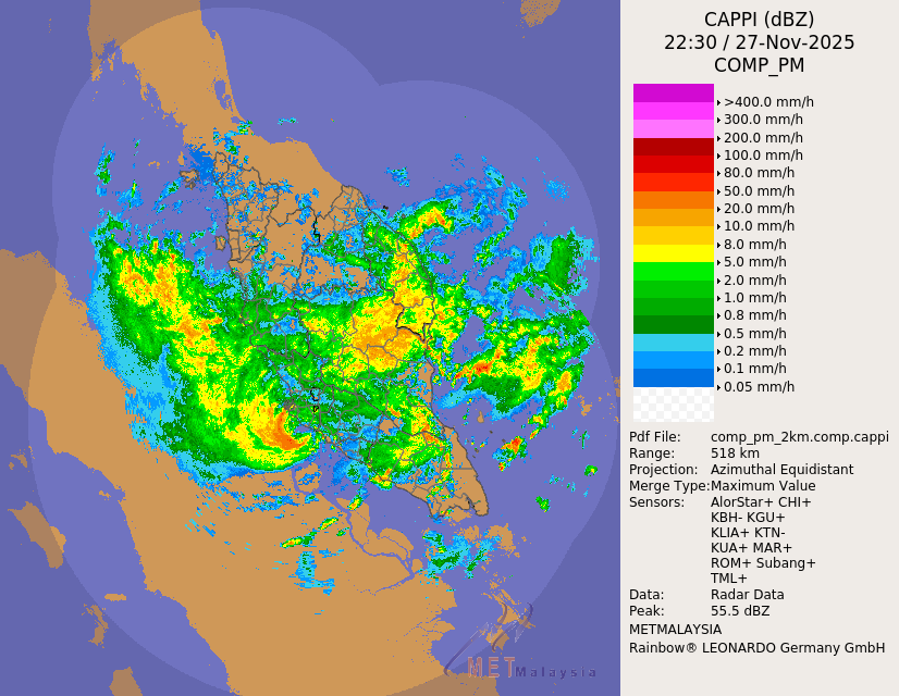
Fascinating to see on radar how the circulation is still intact after crossing Malaysia from the Malacca Strait, making a rare/unprecedented NIO→WPAC crossover!

3 likes
-
AJC3
- Admin
- Posts: 4156
- Age: 62
- Joined: Tue Aug 31, 2004 7:04 pm
- Location: Ballston Spa, New York
- Contact:
Re: WPAC: SENYAR -Tropical Depression
doomhaMwx wrote:Fascinating to see on radar how the circulation is still intact after crossing Malaysia from the Malacca Strait, making a rare/unprecedented NIO→WPAC crossover!
https://i.imgur.com/IdYWYQa.gif
Was/is there archived radar data from the previous 24-48 hours from this radar site? The last dataset on Brian McNoldy's radar page is from Melissa.
0 likes
-
doomhaMwx
- Category 5
- Posts: 2496
- Age: 27
- Joined: Tue Apr 18, 2017 4:01 am
- Location: Baguio/Benguet, Philippines
- Contact:
Re: WPAC: SENYAR -Tropical Depression
AJC3 wrote:doomhaMwx wrote:Fascinating to see on radar how the circulation is still intact after crossing Malaysia from the Malacca Strait, making a rare/unprecedented NIO→WPAC crossover!
https://i.imgur.com/IdYWYQa.gif
Was/is there archived radar data from the previous 24-48 hours from this radar site? The last dataset on Brian McNoldy's radar page is from Melissa.
No complete archive, unfortunately. Some radar scans last night just before it made landfall:


2 likes
-
Hurricane2022

- Category 5
- Posts: 2096
- Joined: Tue Aug 23, 2022 11:38 pm
- Location: Araçatuba, Brazil
Re: WPAC: SENYAR - Tropical Depression
WTPN32 PGTW 282100
MSGID/GENADMIN/JOINT TYPHOON WRNCEN PEARL HARBOR HI//
SUBJ/TROPICAL DEPRESSION 34W (THIRTYFOUR) WARNING NR 008//
RMKS/
1. TROPICAL DEPRESSION 34W (THIRTYFOUR) WARNING NR 008
02 ACTIVE TROPICAL CYCLONES IN NORTHWESTPAC
MAX SUSTAINED WINDS BASED ON ONE-MINUTE AVERAGE
WIND RADII VALID OVER OPEN WATER ONLY
---
WARNING POSITION:
281800Z --- NEAR 4.5N 105.1E
MOVEMENT PAST SIX HOURS - 070 DEGREES AT 06 KTS
POSITION ACCURATE TO WITHIN 030 NM
POSITION BASED ON CENTER LOCATED BY A COMBINATION OF
SATELLITE AND RADAR
PRESENT WIND DISTRIBUTION:
MAX SUSTAINED WINDS - 030 KT, GUSTS 040 KT
WIND RADII VALID OVER OPEN WATER ONLY
REPEAT POSIT: 4.5N 105.1E
---
FORECASTS:
12 HRS, VALID AT:
290600Z --- 5.5N 106.8E
MAX SUSTAINED WINDS - 035 KT, GUSTS 045 KT
WIND RADII VALID OVER OPEN WATER ONLY
RADIUS OF 034 KT WINDS - 000 NM NORTHEAST QUADRANT
040 NM SOUTHEAST QUADRANT
045 NM SOUTHWEST QUADRANT
050 NM NORTHWEST QUADRANT
VECTOR TO 24 HR POSIT: 050 DEG/ 11 KTS
---
24 HRS, VALID AT:
291800Z --- 6.9N 108.6E
MAX SUSTAINED WINDS - 035 KT, GUSTS 045 KT
WIND RADII VALID OVER OPEN WATER ONLY
RADIUS OF 034 KT WINDS - 000 NM NORTHEAST QUADRANT
060 NM SOUTHEAST QUADRANT
060 NM SOUTHWEST QUADRANT
000 NM NORTHWEST QUADRANT
VECTOR TO 36 HR POSIT: 050 DEG/ 11 KTS
---
36 HRS, VALID AT:
300600Z --- 8.3N 110.2E
MAX SUSTAINED WINDS - 025 KT, GUSTS 035 KT
WIND RADII VALID OVER OPEN WATER ONLY
DISSIPATING AS A SIGNIFICANT TROPICAL CYCLONE OVER WATER
VECTOR TO 48 HR POSIT: 055 DEG/ 12 KTS
---
EXTENDED OUTLOOK:
48 HRS, VALID AT:
301800Z --- 9.7N 112.1E
MAX SUSTAINED WINDS - 020 KT, GUSTS 030 KT
WIND RADII VALID OVER OPEN WATER ONLY
DISSIPATED AS A SIGNIFICANT TROPICAL CYCLONE OVER WATER
---
REMARKS:
282100Z POSITION NEAR 4.8N 105.5E.
28NOV25. TROPICAL DEPRESSION 34W (THIRTYFOUR), LOCATED
APPROXIMATELY 390 NM SOUTH-SOUTHWEST OF HO CHI MINH CITY, VIETNAM,
HAS TRACKED EAST-NORTHEASTWARD AT 06 KNOTS OVER THE PAST SIX HOURS.
AVAILABLE METEOROLOGICAL DATA SUPPORTS THE REGENERATION OF
TC 04B, WARNED AS TD 34W, THEREFORE JTWC IS RESUMING WARNINGS.
MINIMUM CENTRAL PRESSURE AT 281800Z IS 1003 MB. MAXIMUM SIGNIFICANT
WAVE HEIGHT AT 281800Z IS 10 FEET. NEXT WARNINGS AT 290300Z, 290900Z,
291500Z AND 292100Z. REFER TO TROPICAL STORM 33W (KOTO) WARNINGS
(WTPN31 PGTW) FOR SIX-HOURLY UPDATES.//
0 likes
Sorry for the bad English sometimes...!
For reliable and detailed information for any meteorological phenomenon, please consult the National Hurricane Center, Joint Typhoon Warning Center , or your local Meteo Center.
--------
ECCE OMNIA NOVA FACIAM (Ap 21,5).
For reliable and detailed information for any meteorological phenomenon, please consult the National Hurricane Center, Joint Typhoon Warning Center , or your local Meteo Center.
--------
ECCE OMNIA NOVA FACIAM (Ap 21,5).
Who is online
Users browsing this forum: No registered users and 48 guests