2026 ENSO Updates

This is the general tropical discussion area. Anyone can take their shot at predicting a storms path.

Moderator: S2k Moderators

Forum rules

The posts in this forum are NOT official forecasts and should not be used as such. They are just the opinion of the poster and may or may not be backed by sound meteorological data. They are NOT endorsed by any professional institution or STORM2K. For official information, please refer to products from the National Hurricane Center and National Weather Service.

Help Support Storm2K
Message
Author
User avatar
cycloneye
Admin
Admin
Posts: 148478
Age: 69
Joined: Thu Oct 10, 2002 10:54 am
Location: San Juan, Puerto Rico

2026 ENSO Updates

#1 Postby cycloneye » Mon Nov 10, 2025 8:20 am

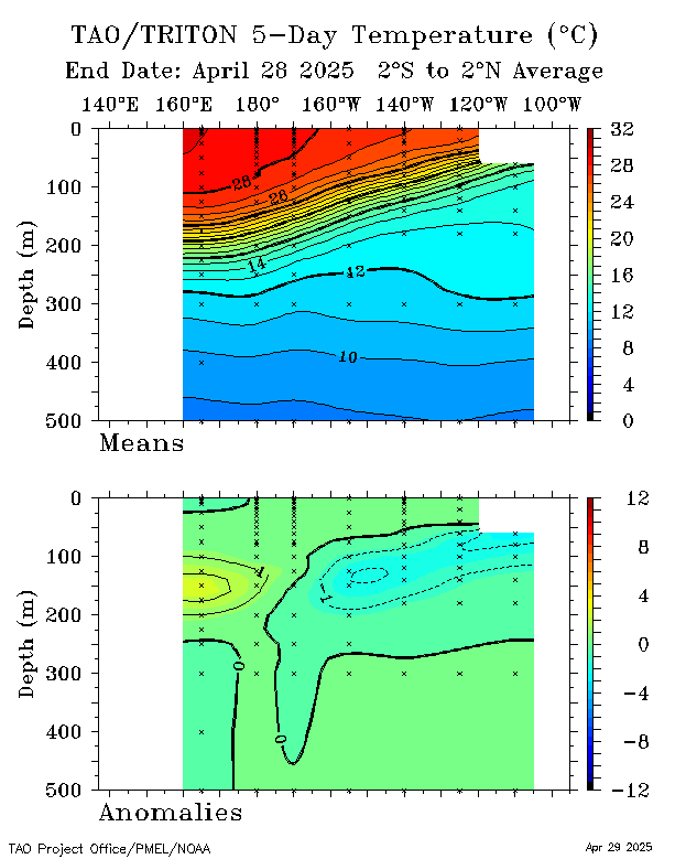
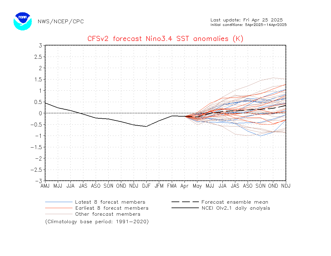
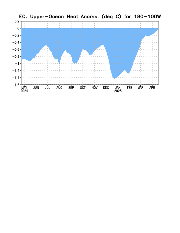
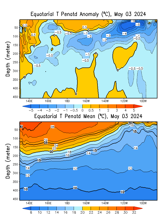
Ok folks, is early but decided to make the 2026 ENSO Updates thread as members will be interested to know if the forecast for El Niño will come and how strong it may be if it forms.

PDO data

2025 and past years ENSO Updates

ONI data

Image

Image

Image

Image

Image

Image

Image

Image

Image

Image

Image

Image

Image

Image

Image


 https://x.com/webberweather/status/1987866201880715454

1 likes   
Visit the Caribbean-Central America Weather Thread where you can find at first post web cams,radars
and observations from Caribbean basin members Click Here

User avatar
cycloneye
Admin
Admin
Posts: 148478
Age: 69
Joined: Thu Oct 10, 2002 10:54 am
Location: San Juan, Puerto Rico

Re: 2026 ENSO Updates

#2 Postby cycloneye » Mon Nov 10, 2025 9:21 am

CPC 11/10/25 weekly update has NIño 3.4 at -0.7C.

https://www.cpc.ncep.noaa.gov/products/ ... ts-web.pdf
0 likes   
Visit the Caribbean-Central America Weather Thread where you can find at first post web cams,radars
and observations from Caribbean basin members Click Here

User avatar
cycloneye
Admin
Admin
Posts: 148478
Age: 69
Joined: Thu Oct 10, 2002 10:54 am
Location: San Juan, Puerto Rico

Re: 2026 ENSO Updates

#3 Postby cycloneye » Mon Nov 10, 2025 10:13 am

From Kingarabian at the 2025 thread.

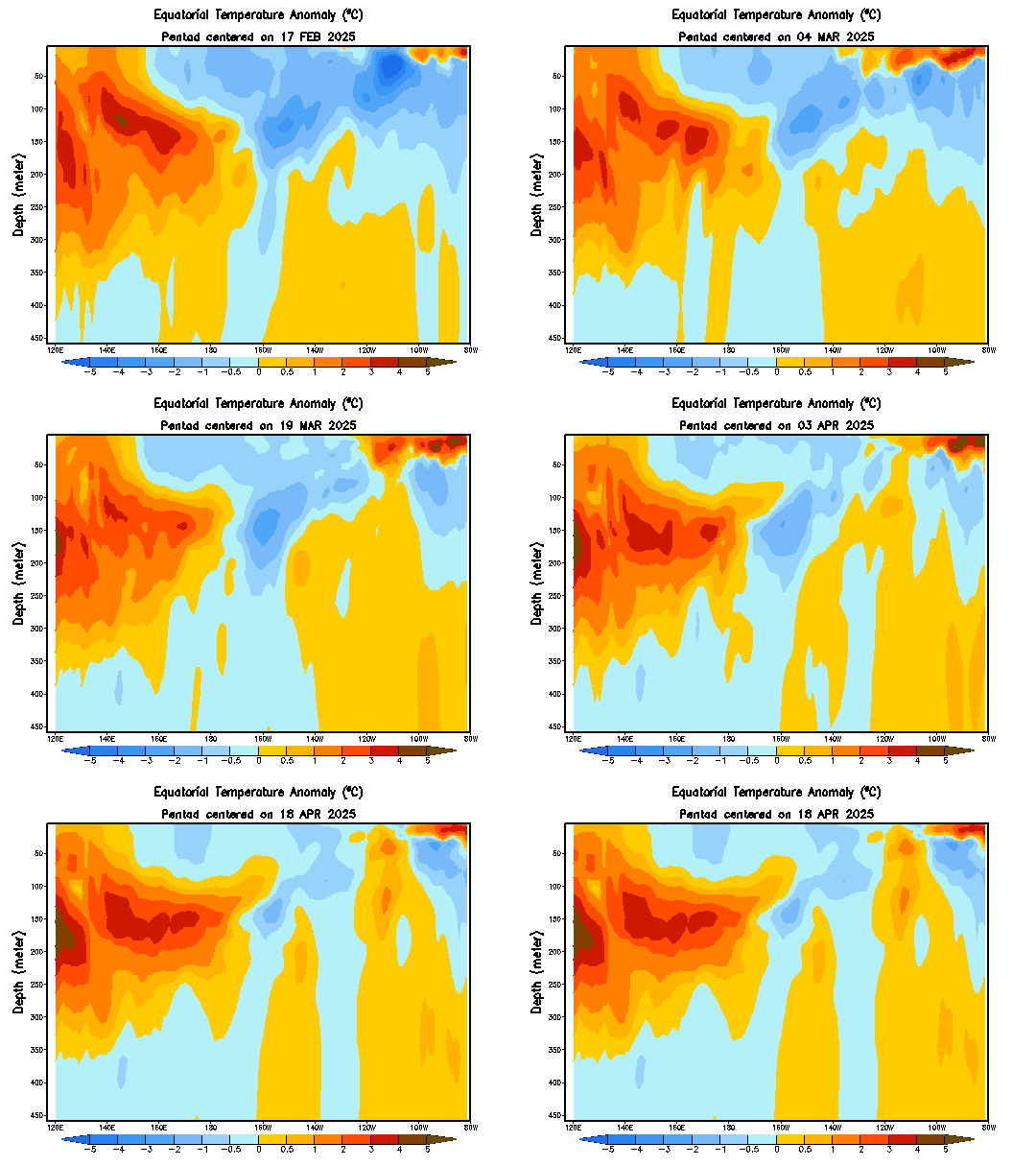
Looks like a strong WWB is setting up over the MC over the next 2 weeks. Should reinforce the WPAC warm pull and we should see a strong downwelling KW setup. Still a long way to go though and nothing is certain.
0 likes   
Visit the Caribbean-Central America Weather Thread where you can find at first post web cams,radars
and observations from Caribbean basin members Click Here

User avatar
Category5Kaiju
Category 5
Category 5
Posts: 4285
Joined: Thu Dec 24, 2020 12:45 pm
Location: Seattle and Phoenix

Re: 2026 ENSO Updates

#4 Postby Category5Kaiju » Mon Nov 10, 2025 10:14 am

Interesting discussions on there.

Was there ever a time in recorded history when a strong or, at least, significant El Niño came merely 3 years after another strong event? My assumption would be that a warm neutral or weak El Niño may be more likely, but I could easily be wrong.
1 likes   
Unless explicitly stated, all info in my posts is based on my own opinions and observations. Tropical storms and hurricanes can be extremely dangerous. Refer to an accredited weather research agency or meteorologist if you need to make serious decisions regarding an approaching storm.

User avatar
Teban54
Category 5
Category 5
Posts: 3761
Joined: Sat May 19, 2018 1:19 pm

Re: 2026 ENSO Updates

#5 Postby Teban54 » Mon Nov 10, 2025 11:00 am

Category5Kaiju wrote:Interesting discussions on there.

Was there ever a time in recorded history when a strong or, at least, significant El Niño came merely 3 years after another strong event? My assumption would be that a warm neutral or weak El Niño may be more likely, but I could easily be wrong.

Looking at historical ONI values alone, and mostly looking at ONI above 1.0:

  • 1963-1965 (2 years): ONI peaked at 1.4 in OND 1963, then 2.0 in SON and OND 1965.
  • 1969-1972 (3 years): Both 1968-69 and 1969-70 were El Ninos with ONI peaking at 1.1 and 0.9 respectively. 3 years later, 1972 was a super Nino at 2.1 in OND and NDJ.
  • 1991-1994 (3 years): ONI peaked at 1.7 in DJF 1992, then 1.1 in NDJ 1994.
  • 1994-1997 (3 years): ONI peaked at 1.1 in NDJ 1994, then 2.4 in OND and NDJ 1997.
0 likes   

User avatar
cycloneye
Admin
Admin
Posts: 148478
Age: 69
Joined: Thu Oct 10, 2002 10:54 am
Location: San Juan, Puerto Rico

Re: 2026 ENSO Updates

#6 Postby cycloneye » Mon Nov 10, 2025 12:21 pm

Image

Image
0 likes   
Visit the Caribbean-Central America Weather Thread where you can find at first post web cams,radars
and observations from Caribbean basin members Click Here

jconsor
Professional-Met
Professional-Met
Posts: 569
Joined: Mon Jun 30, 2008 9:31 pm
Location: Jerusalem, Israel
Contact:

Re: 2026 ENSO Updates

#7 Postby jconsor » Tue Nov 11, 2025 4:57 am

Nice charts, cycloneye. Could you please post links for them? Thanks.

0 likes   

User avatar
cycloneye
Admin
Admin
Posts: 148478
Age: 69
Joined: Thu Oct 10, 2002 10:54 am
Location: San Juan, Puerto Rico

Re: 2026 ENSO Updates

#8 Postby cycloneye » Tue Nov 11, 2025 5:55 am

jconsor wrote:Nice charts, cycloneye. Could you please post links for them? Thanks.


Dont have the links as they were posted at the X chat by Eric Webb without them.
1 likes   
Visit the Caribbean-Central America Weather Thread where you can find at first post web cams,radars
and observations from Caribbean basin members Click Here

WeatherBoy2000
Category 1
Category 1
Posts: 448
Joined: Mon Apr 10, 2023 9:29 am

Re: 2026 ENSO Updates

#9 Postby WeatherBoy2000 » Tue Nov 11, 2025 6:14 pm

 https://x.com/webberweather/status/1988367081512022310


TC Activity in 1982 was about as you'd expect in the Northern Hemisphere during a super el nino, very active epac/wpac, and very inactive Atlantic. It's still way too far out to anticipate a strong/super El Niño, but things seem to be setting up well for a push towards +enso in 2026.
1 likes   

User avatar
cycloneye
Admin
Admin
Posts: 148478
Age: 69
Joined: Thu Oct 10, 2002 10:54 am
Location: San Juan, Puerto Rico

Re: 2026 ENSO Updates: CPC Nov update 11/13/25= Weak La Niña thru Dec; Transition to Neutral Jan - Mar (61%)

#10 Postby cycloneye » Thu Nov 13, 2025 9:21 am

CPC on the november update has La Niña not lasting too long as Neutral conditions are favored to be present between January and March 2026. El niño is up to 40% by JAS.

 https://x.com/NWSCPC/status/1988970114096443779


https://www.cpc.ncep.noaa.gov/products/ ... disc.shtml
0 likes   
Visit the Caribbean-Central America Weather Thread where you can find at first post web cams,radars
and observations from Caribbean basin members Click Here

User avatar
Kingarabian
S2K Supporter
S2K Supporter
Posts: 16275
Joined: Sat Aug 08, 2009 3:06 am
Location: Honolulu, Hawaii

Re: 2026 ENSO Updates: CPC Nov update 11/13/25= Weak La Niña thru Dec; Transition to Neutral Jan - Mar (61%)

#11 Postby Kingarabian » Thu Nov 13, 2025 11:29 am

30 day SOI finally resembles La Nina in the atmosphere.
2 likes   
RIP Kobe Bryant

dexterlabio
Category 5
Category 5
Posts: 3499
Joined: Sat Oct 24, 2009 11:50 pm

Re: 2026 ENSO Updates

#12 Postby dexterlabio » Fri Nov 14, 2025 7:59 pm

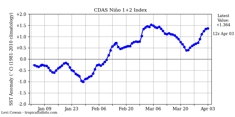
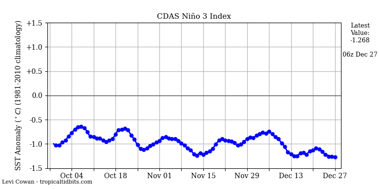
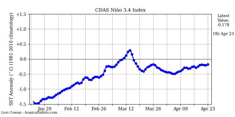
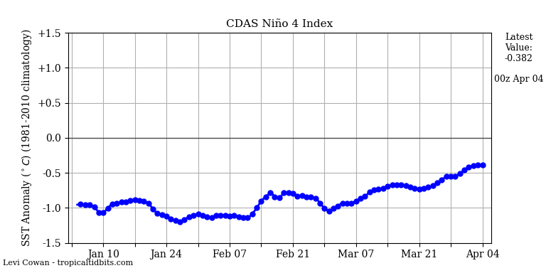
Based on those CDAS Niño indices, no wonder WPAC has been dead (Niño 4 and Niño 3 being very negative)
1 likes   
Personal Forecast Disclaimer:
The posts in this forum are NOT official forecast and should not be used as such. They are just the opinion of the poster and may or may not be backed by sound meteorological data. They are NOT endorsed by any professional institution or storm2k.org. For official information, please refer to the NHC and NWS products.

User avatar
cycloneye
Admin
Admin
Posts: 148478
Age: 69
Joined: Thu Oct 10, 2002 10:54 am
Location: San Juan, Puerto Rico

Re: 2026 ENSO Updates

#13 Postby cycloneye » Fri Nov 14, 2025 8:33 pm

0 likes   
Visit the Caribbean-Central America Weather Thread where you can find at first post web cams,radars
and observations from Caribbean basin members Click Here

User avatar
Kingarabian
S2K Supporter
S2K Supporter
Posts: 16275
Joined: Sat Aug 08, 2009 3:06 am
Location: Honolulu, Hawaii

Re: 2026 ENSO Updates

#14 Postby Kingarabian » Fri Nov 14, 2025 10:18 pm

Waters east of Japan are now just slightly above average. NW of Hawaii those waters remain well above average. Need those to cool by January and maybe then we can finally see a +PDO.
0 likes   
RIP Kobe Bryant


Return to “Talkin' Tropics”

Who is online

Users browsing this forum: ncforecaster89 and 70 guests